
Abstract:
This essay uses topographic map evidence to interpret landform origins in the South Fork Republican River-North Fork Smoky Hill River drainage divide area in Kit Carson County, Colorado. The South Fork Republican River flows in a northeast direction across western and north central Kit Carson County and then flows in a northeast direction to southern Nebraska where it joins the east oriented Republican River with water eventually reaching the Kansas River. East-northeast, northeast, and north-northeast oriented South Fork Republican River tributaries drain large regions of Kit Carson County. The North Fork Smoky Hill River flows in an east-northeast direction across the south half of the southeast quadrant of Kit Carson County and once in Kansas turns to flow in a southeast direction to join the east oriented Smoky Hill River with water eventually reaching the Kansas River. Drainage divides between north-northeast and northeast oriented South Fork Republican River tributaries and the North Fork Smoky Hill River, the north-northeast and northeast oriented South Fork Republican River tributaries, and the South Fork Republican River and its northeast and north-northeast oriented tributaries are crossed by shallow through valleys linking north-northwest tributaries to the northeast and north-northeast oriented trunk streams with southeast and south-southeast oriented and barbed tributaries to the northeast and north-northeast oriented trunk streams. The through valleys, trunk stream tributary orientations, and barbed tributaries were eroded by south-southeast and/or southeast flood flow that crossed Kit Carson County as deeper northeast and north-northeast oriented Republican River tributary valleys eroded headward into the region and captured the massive flood flow. Floodwaters were derived from the western margin of a thick North American ice sheet and flowed from western Canada to and across Kit Carson County as deep Smoky Hill River and Republican River tributary valleys eroded headward into the region. Headward erosion of the deep north-northeast and northeast oriented trunk stream valleys beheaded the south-southeast and/or southeast oriented flood flow routes in sequence from the southeast to the northwest with headward erosion of each trunk stream valley beheading flood flow routes to the newly eroded trunk stream valley immediately to the southeast. Floodwaters on northwest or north-northwest ends of beheaded flood flow routes reversed flow direction to create northwest and/or north-northwest oriented tributary drainage routes.
Preface
The following interpretation of detailed topographic map evidence is one of a series of essays describing similar evidence for all major drainage divides contained within the Missouri River drainage basin and for all major drainage divides with adjacent drainage basins. The research project is interpreting evidence in the context of a previously unexplored deep glacial erosion paradigm, which is fundamentally different from most commonly accepted North American glacial history interpretations. Project essays are listed on the sidebar category list under their appropriate Missouri River tributary drainage basin, Missouri River segment drainage basin (by state), and/or state in which the Missouri River drainage basin is located.
Introduction
The purpose of this essay is to use topographic map interpretation methods to explore the South Fork Republican River-North Fork Smoky Hill River drainage divide area landform origins in Kit Carson County, Colorado. Map interpretation methods can be used to unravel many geomorphic events leading up to formation of present-day drainage routes and development of other landform features. While each detailed topographic map feature provides detailed evidence to be explained, the solution must be consistent with explanations for adjacent area map evidence as well as solutions to big picture map evidence puzzles. I invite readers to improve upon my solutions and/or to propose alternate solutions that better explain evidence and are also consistent with adjacent map area and big-picture evidence. Readers may do so either by making comments here or by writing and publishing their own essays and then by leaving a link to those essays in a comment here.
This essay is also exploring a new geomorphology paradigm in which erosional landforms are interpreted as evidence left by immense glacial melt water floods. Implied in that interpretation is the immense floods were derived from a thick North American ice sheet that created a deep “hole” in the North American continent and also melted fast. The previously unexplored paradigm being tested in this and other Missouri River drainage basin landform origins research project essays is a thick North American ice sheet, comparable in thickness to the Antarctic ice sheet, occupied the North American region usually recognized to have been glaciated, and through its weight and erosive actions created a deep North American “hole”. The southwestern rim of that deep “hole” is today preserved in the high Rocky Mountains. The ice sheet through its weight and deep erosion (and perhaps deposition along major south-oriented melt water flow routes) caused significant crustal warping and tectonic change, through its action of melting fast produced immense floods that flowed across the continent, and through its action of melting fast systematically opened up space in the ice sheet created “hole” so headward erosion of newly developed north-oriented drainage systems captured immense south-oriented melt water floods and diverted immense melt water floods north into space the ice sheet had once occupied.
If this previously unexplored paradigm is correct the geographic region explored by this essay should contain evidence of immense floods that were captured by headward erosion of new valley systems so as to cause the floods to flow in a different direction. Ability of this previously unexplored paradigm to explain South Fork Republican River-North Fork Smoky Hill River drainage divide area landform evidence in Kit Carson County, Colorado will be regarded as evidence supporting the “thick ice sheet that melted fast” paradigm.
South Fork Republican River-North Fork Smoky Hill River drainage divide area location map

Figure 1: South Fork Republican River-North Fork Smoky Hill River drainage divide area location map (select and click on maps to enlarge). National Geographic Society map digitally presented using National Geographic Society TOPO software.
Figure 1 provides a location map for the South Fork Republican River-North Fork Smoky Hill River drainage divide area in Kit Carson County, Colorado and illustrates a region in eastern Colorado with northwest Kansas and southwest Nebraska to the east. The South Platte River flows in a northeast direction across the northwest corner of figure 1 and north of figure 1 flows into western Nebraska with water flowing to the Platte River, which then flows to the Missouri River, which in turn eventually flows to the Mississippi River. Big Sandy Creek flows in a southeast direction across the southwest corner of figure 1 and south of figure 1 Big Sandy Creek turns to flow in a south direction to flow to the east oriented Arkansas River, which eventually flows directly to the Mississippi River. The South Fork Republican River originates a short distance east of Big Sandy Creek (near Hugo, Colorado) and flows in a northeast direction to join the Republican River near Benkleman, Nebraska. The Republican River flows in roughly an east direction from Benkleman until east of figure 1 its turns in a southeast direction to join the Smoky Hill River and to form the Kansas River, which then flows to the Missouri River. Multiple northeast and east-northeast oriented tributaries join the South Fork Republican River in eastern Colorado. Northeast oriented streams flowing across the northwest corner of Kansas are Republican River tributaries. The North Fork Smoky Hill River is located south of the South Fork Republican River and originates in eastern Colorado near the south edge of figure 1 and then flows in an east-northeast and southeast direction to join the Smoky Hill River near Russell Springs, Kansas. The Smoky Hill River then flows in an east direction across Kansas to join the Republican River and to form the Kansas River, which flows to the Missouri River. The South Fork Republican River-North Fork Smoky Hill River drainage divide in Kit Carson County, Colorado area investigated in this essay is located south and east of the South Fork Republican River, north of the North Fork Smoky Hill River, and west of the Colorado-Kansas state line.
Drainage routes in Colorado, Nebraska, and Kansas developed during immense melt water floods from a thick North American ice sheet. Floodwaters from western Canada crossed the region seen in figure 1 at a time when deep east oriented valleys were eroding headward into western Kansas, western Nebraska, and eastern Colorado from what was an evolving Mississippi-Missouri River drainage system. The deep valleys eroded headward into the region in sequence from the south and east to the north and west to capture the massive south oriented flood flow and divert floodwaters to the developing Mississippi-Missouri River drainage system. Headward erosion of deep valleys sometimes changed flood flow directions from south to southeast, which caused many east oriented valleys to erode headward in southwest directions across the southeast oriented flood flow. Headward erosion of the east oriented Smoky Hill River valley (south of figure 1) captured the south and southeast oriented flood flow, which had previously been flowing to what at that time was the newly eroded Arkansas River valley (south of figure 1). The North Fork Smoky Hill River valley then eroded headward along a southeast flood flow channel prior to eroding headward in a west-southwest direction across south-southeast oriented flood flow into eastern Colorado. Headward erosion of northeast oriented Republican River tributary valleys (Beaver Creek and Little Beaver Creek) next captured southeast oriented flood flow in western Kansas, but did not erode far into eastern Colorado. Headward erosion of the northeast oriented South Fork Republican River valley next beheaded southeast oriented flood flow routes to the newly eroded Little Beaver Creek valley in western Kansas and the east-northeast oriented North Fork Smoky Hill River valley in Kit Carson County, Colorado, with headward erosion of each South Fork Republican River tributary valley beheading southeast or south-southeast oriented flood flow routes to the newly eroded tributary valley immediately to the southeast. Headward erosion of the northeast oriented Arikaree River valley then beheaded flood flow routes to the newly eroded South Fork Republican River valley and headward erosion of the northeast oriented South Platte River valley beheaded southeast oriented flood flow routes to the newly eroded Arikaree River valley. Evidence for these flood flow captures is visible on detailed topographic maps, a few of which are illustrated and discussed in this essay.
Detailed location map for South Fork Republican River-North Fork Smoky Hill River drainage divide area
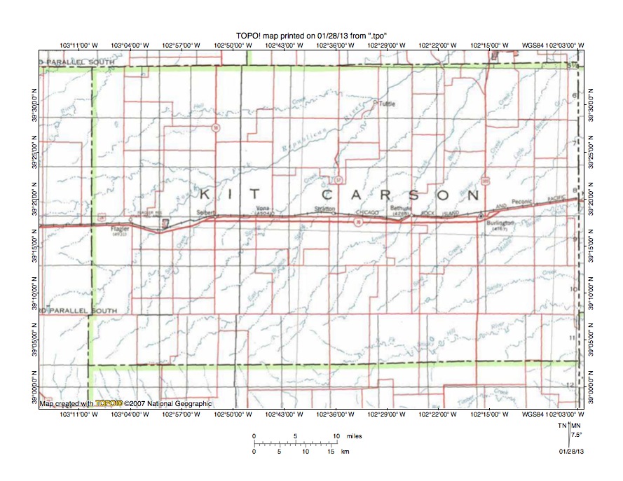
Figure 2: Detailed location map South Fork Republican River-North Fork Smoky Hill River drainage divide area. United States Geological Survey map digitally presented using National Geographic Society TOPO software.
Figure 2 provides a detailed location map for the South Fork Republican River-North Fork Smoky Hill River drainage divide area in Kit Carson County, Colorado. County lines are shown and Kit Carson County is labeled. The north-to-south oriented Colorado-Kansas state line is located along the east edge of figure 2. The North Fork Smoky Hill River originates just south of Kit Carson County near the south center edge of figure 2 and then flows in an east-northeast direction across the southeast corner of figure 2. East of figure 2 the North Fork Smoky Hill River flows in a southeast direction to join the east oriented Smoky Hill River with water eventually reaching the Kansas and Missouri Rivers. The North Fork Smoky Hill River has very few tributaries shown in figure 2. Labeled streams flowing to the east edge of figure 2 north of the North Fork Smoky River (from south to north) are Beaver Creek tributaries and include Sandy Creek, Middle Beaver Creek, and Little Beaver Creek, with Beaver Creek flowing to the north edge of figure 2 (near the northeast corner). North and east of figure 2 Beaver Creek flows in a northeast direction to join the east and southeast oriented Republican River with water eventually reaching the Kansas and Missouri Rivers. The labeled north-northeast oriented stream located immediately west and north of Beaver Creek and which flows from Bethune to the north edge of figure 2 (east half) is Landsman Creek, which north of figure 2 joins the northeast oriented South Fork Republican River. The South Fork Republican River flows in a northeast direction from the west edge of figure 2 (south half) to the Flagler Reservoir State Recreation Area and then to near Tuttle before reaching the north edge of figure 2 (east half). North of figure 2 the South Fork Republican River flows in a northeast direction to join the east and southeast oriented Republican River, which eventually joins the Smoky Hill River to form the Kansas River. Sand Creek is a north-northeast oriented South Fork Republican River tributary flowing just west of Seibert. Spring Creek is a northeast oriented South Fork Republican River tributary east of Sand Creek and flows near Vona before joining the South Fork Republican River near Tuttle. The East Branch Spring Creek is located east of Spring Creek and flows in a north-northeast direction just west of Stratton. Topographic maps discussed in this essay illustrate the Landsman Creek-North Fork Smoky Hill River drainage divide area, the Spring Creek-Landsman Creek drainage divide area, the Sand Creek-Spring Creek drainage divide area, and the South Fork Republican River-Sand Creek drainage divide area.
Landsman Creek-North Fork Smoky Hill River drainage divide area
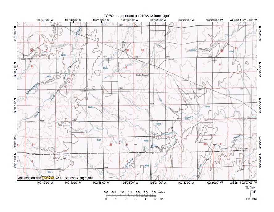
Figure 3: Landsman Creek-North Fork Smoky Hill River drainage divide area. United States Geological Survey map digitally presented using National Geographic Society TOPO software.
Figure 3 provides a topographic map of Landsman Creek-North Fork Smoky Hill River drainage divide area. The map contour interval for figure 3 is 10 meters. The North Fork Smoky Hill River flows in a northeast and east direction from the south center edge of figure 3 to the east edge of figure 3 (south of center). East of figure 3 the North Fork Smoky Hill River flows in an east-northeast and southeast direction to eventually join the east oriented Smoky Hill River, which eventually joins the east and southeast oriented Republican River to form the east oriented Kansas River. Tributaries to the North Fork Smoky Hill River shown in figure 3 are predominantly from the north and west and are oriented in southeast directions, which suggests the North Fork Smoky Hill River valley eroded headward across multiple southeast oriented flood flow channels. The northeast oriented stream originating near the northeast corner of figure 3 is Beaver Creek, which north and east of figure 3 flows in a northeast direction to join the east and southeast oriented Republican River. Landsman Creek flows in a northeast and north direction from the west center edge of figure 3 to the north edge of figure 3 (west half). North of figure 3 Landsman Creek flows in a north-northeast direction to join the northeast oriented South Fork Republican River, which then flows to the east and southeast oriented Republican River. The South Fork Landsman Creek is a north-northeast oriented Landsman Creek tributary seen in figure 3. Northeast oriented streams flowing to the north center edge of figure 3 are Landsman Creek tributaries. Additional evidence supporting the southeast flood flow hypothesis would be through valleys crossing the Landsman Creek-North Fork Smoky Hill River drainage divide. There are some hints of such through valleys in figure 3, but the evidence is not convincing. Figure 4 provides a detailed topographic map of a Landsman Creek-North Fork Smoky Hill River drainage divide area to determine whether the lack of convincing evidence for through valleys is due to the 10-meter contour interval or is because there is no convincing evidence.
Detailed map of Landsman Creek-North Fork Smoky Hill River drainage divide area
Figure 4: Detailed map of Landsman Creek-North Fork Smoky Hill River drainage divide area. United States Geological Survey map digitally presented using National Geographic Society TOPO software.
Figure 4 provides a detailed topographic map of the Landsman Creek-North Fork Smoky Hill River drainage divide area seen in less detail in figure 3. The map contour interval for figure 4 is 10 feet. Landsman Creek flows in an east-northeast direction across the northwest corner of figure 4. The South Fork Landsman Creek flows in a north-northeast direction from the west center edge of figure 4 to join Landsman Creek near the north edge of figure 4. A southeast oriented stream originates in the southeast corner of section 10 and flows to the southeast corner of figure 4. South and east of figure 4 that unnamed stream flows to the northeast oriented North Fork Smoky Hill River as a barbed tributary. A south-southeast oriented stream originates in section 15 and flows to the south center edge of figure 4 and south of figure 4 flows to the northeast oriented North Fork Smoky Hill River as a barbed tributary. A shallow northwest-to-southeast oriented through valley in the southwest quadrant of section 10 links the southeast oriented North Fork Smoky Hill River tributary valley with a north-northwest oriented Landsman Creek tributary valley. The through valley is defined by two 10-foot contour lines on the northeast side and by three contour lines on the southwest side. A second through valley of similar depth is located along the border between sections 15 and 16 and links the south-southeast oriented North Fork Smoky Hill River tributary valley with a north-northwest oriented South Fork Landsman Creek tributary valley. A third and slightly shallower through valley in the southwest corner of section 16 links a south-southeast oriented North Fork Smoky Hill tributary valley (seen in section 21) with a north oriented South Fork Landsman Creek tributary valley. These through valleys along with the north and northwest oriented South Fork and Landsman Creek tributaries confirms that multiple southeast oriented flood flow channels crossed the Landsman Creek-North Fork Smoky Hill River drainage divide area prior to headward erosion of the deeper Landsman Creek and South Fork Landsman Creek valleys. Headward erosion of the Landsman Creek-South Fork Landsman Creek valleys beheaded the southeast oriented flood flow channels and floodwaters on northwest ends of the beheaded flood flow channels reversed flow direction to create the northwest and north oriented Landsman Creek and South Fork Landsman Creek tributary drainage routes.
Spring Creek-Landsman Creek drainage divide area
Figure 5: Spring Creek-Landsman Creek drainage divide area. United States Geological Survey map digitally presented using National Geographic Society TOPO software.
Figure 5 illustrates a topographic map of the Spring Creek-Landsman Creek drainage divide area north and west of figure 3 and includes an overlap area with figure 3. The map contour interval for figure 5 is 10 meters. Landsman Creek flows in a north-northeast direction from the south edge of figure 5 (slightly east of center) to the east edge of figure 5 (north half). East and north of figure 5 Landsman Creek flows in a north-northeast direction to the northeast oriented South Fork Republican River, which then flows to the east oriented Republican River. The East Branch Spring Creek flows in a north-northeast direction from the south edge of figure 5 (near southwest corner) to the north edge of figure 5 (slightly east of center). North of figure 5 East Branch Spring Creek joins north-northeast oriented Spring Creek. Spring Creek flows in a north-northeast direction across the northwest corner of figure 5 and north of figure 5 joins the northeast oriented South Fork Republican River. Assuming the flood flow hypothesis is correct headward erosion of the north-northeast oriented East Branch Spring Creek valley should have beheaded southeast oriented flood flow channels leading to the newly eroded Landsman Creek valley and headward erosion of the north-northeast oriented Spring Creek valley should have beheaded southeast oriented flood flow channels leading to the newly eroded East Branch Spring Creek valley. Like with figure 3 the map in figure 5 does not show convincing evidence that the north-northeast oriented valleys eroded headward across southeast oriented flood flow channels and figure 6 provides a detailed map of an East Branch Spring Creek-Landsman Creek drainage divide area to further test the flood flow hypothesis.
Detailed map of East Branch Spring Creek-Landsman Creek drainage divide area

Figure 6: Detailed map of East Branch Spring Creek-Landsman Creek drainage divide area. United States Geological Survey map digitally presented using National Geographic Society TOPO software.
Figure 6 provides a detailed topographic map of the East Branch Spring Creek-Landsman Creek drainage divide area seen in less detail in figure 5. The map contour interval for figure 6 is 10 feet. The East Branch Spring Creek flows in a north-northeast direction across the northwest corner of figure 6. The north-northeast oriented stream flowing from the southwest corner of figure 6 to the north center edge of figure 6 joins East Branch Spring Creek north of figure 6. The east-northeast oriented stream originating in section 24 and flowing to the east center edge of figure 6 joins north-northeast oriented Landsman Creek just east of figure 6. In the north half of section 24 two shallow through valleys link north-northwest oriented tributaries to the north-northeast oriented East Branch Spring Creek valley with the east-northeast oriented Landsman Creek tributary valley. The east wall of the through valleys is defined by three 10-foot contour lines and the west wall is defined by six contour lines. Further to the north in the northwest quadrant of section 18 another through valley links a southeast oriented tributary valley to the east-northeast Landsman Creek tributary with a north-northwest tributary valley to the north-northeast oriented East Branch Spring Creek tributary and is defined by at least two contour lines on each side. Near the west center edge of figure 6 in section 14 a through valley links a north-northwest oriented East Branch Spring Creek tributary valley with the north-northeast East Branch Spring Creek tributary valley. This section 14 through valley is also defined by at least two contour lines on each side. These through valleys, the southeast oriented tributaries to the east-northeast oriented Landsman Creek tributary, and the short north-northwest oriented tributaries to north-northeast oriented East Branch Spring Creek and the north-northeast oriented East Branch Spring tributary provide convincing evidence the East Branch Spring Creek-Landsman Creek drainage divide was crossed by south-southeast oriented flood flow prior to headward erosion of the deeper East Branch Spring Creek tributary valley, which was prior to headward erosion of the deeper East Branch Spring Creek valley. The north-northwest oriented tributary drainage routes were created by reversals of flood flow on north-northwest ends of beheaded flood flow routes.
Sand Creek-Spring Creek drainage divide area
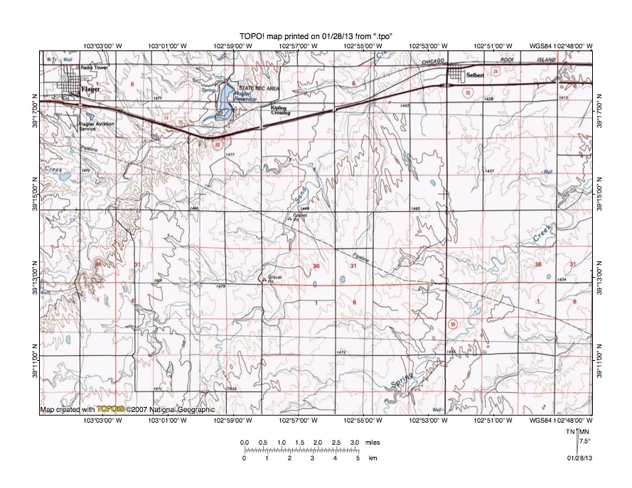
Figure 7: Sand Creek-Spring Creek drainage divide area. United States Geological Survey map digitally presented using National Geographic Society TOPO software.
Figure 7 illustrates a topographic map of the Sand Creek-Spring Creek drainage divide area west and slightly north of figure 5 and there is an overlap area with figure 5. The map contour interval for figure 7 is 10 meters. The South Fork Republican River flows in a northeast direction from the west edge of figure 7 (south of center) to the north edge of figure 7 (west of center) and north of figure 7 flows in a northeast direction to join the east oriented Republican River. Sand Creek flows in a northeast, southeast, and north-northeast direction from the south edge of figure 7 (near southwest corner) to the north edge of figure 7 (slightly east of center). North of figure 7 Sand Creek joins the northeast oriented South Fork Republican River. Spring Creek flows in a northeast or north-northeast direction from the south edge of figure 7 (east of center) to the east edge of figure 7 (north half). East and north of figure 7 Spring Creek joins the northeast oriented South Fork Republican River. Spring Creek, Sand Creek, and the South Fork Republican River all have southeast oriented tributaries visible in figure 7 and Sand Creek has north and north-northwest oriented tributaries. The southeast oriented tributaries flow to the northeast oriented trunk streams as barbed tributaries. While the 10-meter contour interval does not show enough detail to identify through valleys crossing the drainage divides the orientations of the tributary valleys and the barbed tributaries suggest headward erosion of the Spring Creek valley captured southeast and/or south-southeast oriented flood flow channels, which were then beheaded and reversed by headward erosion of the Sand Creek valley and then beheaded and reversed again by headward erosion of the South Fork Republican River valley. To further test this hypothesis figure 8 provides a detailed topographic map of a Sand Creek-Spring Creek drainage divide area to determine whether through valleys cross the drainage divide and whether a more detailed look at tributary orientations supports the flood flow hypothesis.
Detailed map of Sand Creek-Spring Creek drainage divide area
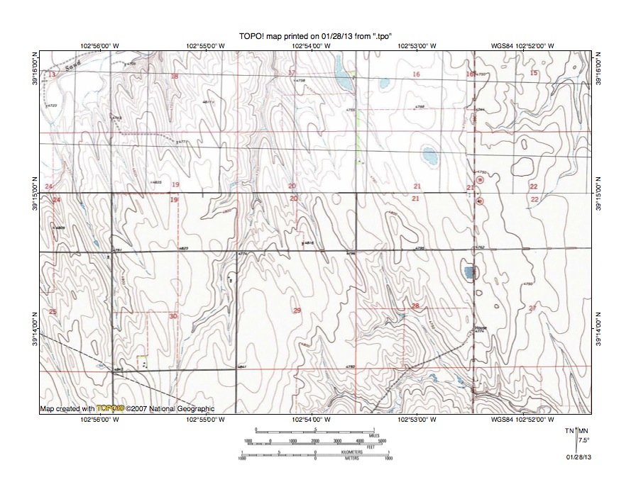
Figure 8: Detailed map of Sand Creek-Spring Creek drainage divide area. United States Geological Survey map digitally presented using National Geographic Society TOPO software.
Figure 8 provides a detailed topographic map of the Sand Creek-Spring Creek drainage divide area seen in less detail figure 7. The map contour interval for figure 8 is 10 feet. Sand Creek flows in an east-northeast direction across the northwest corner of figure 8 and is joined by several north-northwest and north oriented tributaries seen in figure 8. East, southeast, and south-southeast oriented streams seen in the southeast quadrant of figure 8 join along the south edge of figure 8 to flow to northeast oriented Spring Creek. The landscape in figure 8 has been streamlined in a north-northwest to south-southeast direction and identifiable through valleys cross drainage divides. Perhaps the most obvious through valley is located in the southwest quadrant of section 21 and links headwaters of a north-northwest oriented tributary to a north oriented Sand Creek tributary with headwaters of a south-southeast tributary to an east-southeast oriented Spring Creek tributary. The through valley is defined by at least three 10-foot contour lines on a side and is between 20 and 40 feet deep. Other shallower through valleys cross the Sand Creek-Spring Creek drainage divide in section 29 and are defined by a single contour line on the east side. Shallow through valleys also cross drainage divides between Sand Creek and the north-northeast and north oriented Sand Creek tributary flowing from the south edge of figure 8 (west half) to the north edge of figure 8 (west of center). For example in the southeast quadrant of section 18 there is a through valley defined by two contour lines on each side and in section 30 shallow through valleys defined by one contour line on the east side link north-northwest oriented Sand Creek tributary valleys with the north-northeast and north oriented Sand Creek tributary valley. These through valleys provide evidence headward erosion of the north-northeast and north oriented Sand Creek tributary valley captured south-southeast oriented flood flow moving to what was at time the newly eroded Spring Creek valley and then headward erosion of the Sand Creek valley beheaded and reversed flood flow channels to the newly eroded north-northeast and north oriented Sand Creek tributary valley. Headward erosion of these valleys probably occurred in rapid succession as floodwaters deeply eroded the region.
South Fork Republican River-Sand Creek drainage divide area
Figure 9: South Fork Republican River-Sand Creek drainage divide area. United States Geological Survey map digitally presented using National Geographic Society TOPO software.
Figure 9 illustrates a topographic map of the South Fork Republican River-Sand Creek drainage divide area south and west of figure 7 and there is an overlap area with figure 7. The map contour interval for figure 9 is 10 meters. The South Fork Republican River originates near the west center edge of figure 9 and flows in an east-northeast and northeast direction to the north edge of figure 9 (near northeast corner). North and east of figure 9 the South Fork Republican River flows in a northeast direction to join the east and southeast oriented Republican River with water eventually reaching the Kansas, Missouri, and Mississippi Rivers. Short South Fork Republican River tributaries seen in figure 9 are predominantly oriented in southeast directions. Sand Creek originates just south of the southwest quadrant of figure 9 and flows in a northeast, north, east-northeast, north-northeast, east, and north-northeast direction from the south edge of figure 9 (slightly west of center) to the east edge of figure 9 (near northeast corner). East and north of figure 9 Sand Creek joins the northeast oriented South Fork Republican River. The south oriented stream near the southwest corner of figure 9 is a tributary to southeast and south oriented Big Sandy Creek, which flows to the east oriented Arkansas River, which eventually flows directly to the Mississippi River. The South Fork Republican River originates on the floor of an east-northeast and northeast oriented valley eroded into the northwest wall of the deeper southeast oriented Big Sandy Creek valley while Sand Creek headwaters originate near the rim the deep Big Sandy Creek valley wall. This evidence suggests headward erosion of the northeast oriented Republican River tributary valleys occurred at approximately the same time as headward erosion of the southeast and south oriented Big Sandy Creek valley and that for a time headward erosion of the South Fork Republican River valley captured southeast oriented flood flow that was later captured by headward erosion of the deeper southeast and south oriented Big Sandy Creek valley. The southeast oriented tributaries to the northeast oriented valley suggest headward erosion of the deep east-northeast and northeast oriented South Fork Republican River valley captured multiple southeast oriented flood flow channels. However, there is no convincing evidence shown in figure 9 that shows the southeast oriented flood flow crossed the South Fork Republican River-Sand Creek drainage divide. Figure 10 provides a more detailed topographic map of the South Fork Republican River-Sand Creek drainage divide area near the northeast corner of figure 9 to further test the flood flow hypothesis.
Detailed map of South Fork Republican River-Sand Creek drainage divide area
Figure 10: Detailed map of South Fork Republican River-Sand Creek drainage divide area. United States Geological Survey map digitally presented using National Geographic Society TOPO software.
Figure 10 provides a detailed topographic map of a South Fork Republican River-Sand Creek drainage divide area seen in less detail in figure 9. The map contour interval for figure 10 is 10 feet. The South Fork Republican River meanders in an east-northeast direction across the northwest corner of figure 10. Sand Creek meanders in a northeast and east direction from the south center edge of figure 10 to near the east center edge of figure 10 before turning in a north direction to flow along and across the east edge of figure 10. East and north of figure 10 Sand Creek flows in a northeast and north-northeast direction to join the northeast oriented South Fork Republican River. An east oriented Sand Creek tributary originates just west of the west edge of figure 10 (near southwest corner) and flows across sections 15 and 14 to join Sand Creek in section 13. A through valley near the corner of sections 9, 10, 15, and 16 crosses the South Fork Republican River-Sand Creek tributary drainage divide and links a west oriented (and barbed) South Fork Republican River tributary valley with the east oriented Sand Creek tributary valley. The through valley is defined by at least two 10-foot contour lines on each side and is at least 10 feet deep. Several south-southeast and south oriented tributaries join the east oriented Sand Creek tributary in section 14. North of the headwaters of these tributaries are shallow through valleys linking north and north-northwest oriented South Fork Republican River tributary valleys with the south-southeast and south oriented tributaries to the east oriented Sand Creek tributary. The deepest of the through valleys is defined by two contour lines on each side while other through valleys are defined by a single contour line one side. Intermittent lakes located in sections 1, 11, and 12 are located on floors of additional through valleys crossing the South Fork Republican River-Sand Creek drainage divide. Most of these through valleys are defined by only one contour line, although the intermittent lakes and streamlined landscape features emphasize the through valley locations. The through valleys, the west, north, and north-northwest oriented South Fork Republican River tributaries, and north-northwest oriented Sand Creek tributaries (south of section 13) all suggest headward erosion of the Sand Creek valley beheaded and reversed south-southeast oriented flood flow channels, which were subsequently beheaded and reversed by headward erosion of the deeper northeast oriented South Fork Republican River valley. While the flood flow evidence seen in figure 10 and in other figures illustrated in this essay is subtle the evidence exists and demonstrates the region was crossed by southeast and/or south-southeast oriented flood flow as the deeper northeast oriented Republican River tributary valleys eroded headward in sequence (from the east to the west) to capture the massive southeast and/or south-southeast oriented flood flow.
Additional information and sources of maps studied
This essay has provided only a sample of the detailed topographic map evidence supporting the flood erosion interpretation. Many additional illustrations could be provided. Readers are encouraged to look at mosaics of detailed topographic maps to see the abundance of available data. Maps used in this study were created and published by the United States Geologic Survey and can be obtained directly from the United States Geological Survey and/or from dealers offering United States Geological Survey maps. Hard copy maps can also be observed at United States Geological Survey map depositories, which are located throughout the United States and elsewhere. Illustrations used here were created using National Geographic Society TOPO software and digital map data. TOPO software and map data can be obtained from the National Geographic Society and/or dealers offering National Geographic Society digital map data.

Leave a comment