
Abstract:
This essay uses topographic map evidence to interpret landform origins in the Cherry Creek-Plum Creek drainage divide area in Douglas County, Colorado. Cherry Creek is a north and northwest oriented stream joining the north-northeast oriented South Platte River at Denver. Plum Creek is formed at confluence of northeast, north, and northwest oriented East Plum Creek and of north oriented West Plum Creek and flows in a north-northwest direction to join the north-northeast oriented South Platte River south of Denver. The north oriented West and East Plum Creek and Cherry Creek drainage routes are located on the western margin of the Colorado Piedmont, which is located east of the Rampart Range. North and northwest oriented tributaries to the north-northeast oriented South Platte River drain the west side of the Rampart Range while northeast oriented East and West Plum Creek headwaters and tributaries drain the Rampart Range east side. South of the north oriented East Plum Creek and Cherry Creek headwaters are through valleys linking the north oriented valleys with valleys of south oriented tributaries to the east oriented Arkansas River. Shallow through valleys cross West Plum Creek-East Plum Creek drainage divide and the East Plum Creek-Cherry Creek drainage divide and also at much higher elevations the crest of the Rampart Range. Barbed tributaries also flow to north oriented East Plum Creek and to north and northwest-oriented South Platte River tributaries west of the Rampart Range. Buttes provide evidence of deep erosion in the West and East Plum Creek drainage basins east of the Rampart Range. Erosional landforms in the Cherry Creek-Plum Creek drainage divide area are interpreted to have been eroded by immense south oriented floods from the western margin of a thick North American ice sheet, which flowed to and across Colorado at a time when the Rampart Range was beginning to emerge. Headward erosion of the north-northeast oriented South Platte River valley beheaded south oriented flood flow channels along the western margin of the Colorado Piedmont in sequence from east to west. Floodwaters on north ends of beheaded flood flow routes reversed flow direction to create north oriented South Platte River drainage route. Because flood flow routes were beheaded one at a time and in sequence and because flood flow routes diverged and converged reversed flood flow on the Cherry Creek alignment captured south oriented flood flow still moving on the East Plum Creek alignment, which subsequently was beheaded and reversed and which then captured south oriented flood flow still moving west of the emerging Rampart Range. Captured flood flow from west of the Rampart Range helped erode the present day north oriented West and East Plum Creek valleys and to a lesser extent the north oriented Cherry Creek valley.
Preface
The following interpretation of detailed topographic map evidence is one of a series of essays describing similar evidence for all major drainage divides contained within the Missouri River drainage basin and for all major drainage divides with adjacent drainage basins. The research project is interpreting evidence in the context of a previously unexplored deep glacial erosion paradigm, which is fundamentally different from most commonly accepted North American glacial history interpretations. Project essays are listed on the sidebar category list under their appropriate Missouri River tributary drainage basin, Missouri River segment drainage basin (by state), and/or state in which the Missouri River drainage basin is located.
Introduction
The purpose of this essay is to use topographic map interpretation methods to explore the Cherry Creek-Plum Creek drainage divide area landform origins in Douglas County, Colorado. Map interpretation methods can be used to unravel many geomorphic events leading up to formation of present-day drainage routes and development of other landform features. While each detailed topographic map feature provides detailed evidence to be explained, the solution must be consistent with explanations for adjacent area map evidence as well as solutions to big picture map evidence puzzles. I invite readers to improve upon my solutions and/or to propose alternate solutions that better explain evidence and are also consistent with adjacent map area and big-picture evidence. Readers may do so either by making comments here or by writing and publishing their own essays and then by leaving a link to those essays in a comment here.
This essay is also exploring a new geomorphology paradigm in which erosional landforms are interpreted as evidence left by immense glacial melt water floods. Implied in that interpretation is the immense floods were derived from a thick North American ice sheet that created a deep “hole” in the North American continent and also melted fast. The previously unexplored paradigm being tested in this and other Missouri River drainage basin landform origins research project essays is a thick North American ice sheet, comparable in thickness to the Antarctic ice sheet, occupied the North American region usually recognized to have been glaciated, and through its weight and erosive actions created a deep North American “hole”. The southwestern rim of that deep “hole” is today preserved in the high Rocky Mountains. The ice sheet through its weight and deep erosion (and perhaps deposition along major south-oriented melt water flow routes) caused significant crustal warping and tectonic change, through its action of melting fast produced immense floods that flowed across the continent, and through its action of melting fast systematically opened up space in the ice sheet created “hole” so headward erosion of newly developed north-oriented drainage systems captured immense south-oriented melt water floods and diverted immense melt water floods north into space the ice sheet had once occupied.
If this previously unexplored paradigm is correct the geographic region explored by this essay should contain evidence of immense floods that were captured by headward erosion of new valley systems so as to cause the floods to flow in a different direction. Ability of this previously unexplored paradigm to explain Cherry Creek-Plum Creek drainage divide area landform evidence in Douglas County, Colorado will be regarded as evidence supporting the “thick ice sheet that melted fast” paradigm.
Cherry Creek-Plum Creek drainage divide area location map

Figure 1: Cherry Creek-Plum Creek drainage divide area location map (select and click on maps to enlarge). National Geographic Society map digitally presented using National Geographic Society TOPO software.
Figure 1 provides a location map for the Cherry Creek-Plum Creek drainage divide area in Douglas County, Colorado and illustrates an area in Colorado. Elevenmile Canyon Reservoir is located near the south edge of the southwest quadrant of figure 1. The Colorado Front Range is located west of Denver and the Colorado Piedmont is located east of the Front Range. The South Platte River flows in a southeast direction from Hartsel to Elevenmile Canyon Reservoir and then abruptly turns to flow in a north-northeast direction to Denver and almost to Greeley before turning in a southeast, east, and northeast direction to flow to the north edge of figure 1 (near northeast corner). North and east of figure 1 the South Platte River flows into western Nebraska with water eventually reaching the Platte, Missouri, and Mississippi Rivers. In addition to its southeast oriented headwaters several southeast oriented tributaries can be seen flowing to the north-northeast oriented South Platte River. Kiowa Creek, Bijou Creek, and Beaver Creek are among several north oriented tributaries to the east and northeast oriented South Platte River segment near Fort Morgan. Cherry Creek is an unlabeled north and northwest oriented tributary originating east of Palmer Lake (in south center area of figure 1) and flows through Parker to join the South Platte River at Denver. Plum Creek originates north and west of Palmer Lake and flows in a northeast and north direction to Castle Rock and then in a northwest direction through Sedalia and Louviers to join the South Platte River south of Littleton. The Rampart Range is the name for the mountains east of the north-northeast South Platte River in the south half of figure 1 and is a southern extension of the Colorado Front Range. The south oriented stream flowing from near Palmer Lake to the south center edge of figure 1 is a tributary to the east oriented Arkansas River (south of figure 1), which eventually flows directly to the Mississippi River. The Colorado River originates in Rocky Mountain National Park and flows in a south direction to near the southwest corner of Rocky Mountain National Park and then turns in a west-southwest direction to flow through Sulphur Springs and Kremmling to the west edge of figure 1. West of figure 1 the Colorado River eventually reaches the Pacific Ocean. North and northwest oriented Colorado River tributaries originate near the headwaters of the southeast oriented South Platte River tributaries. Today deep mountain passes link valleys of the north and northwest oriented Colorado River tributaries with the valleys of the south and southeast oriented South Platte River headwaters and tributaries. The Cherry Creek-Plum Creek drainage area investigated in this essay is located west of Cherry Creek and east of Plum Creek and includes Plum Creek headwaters in the Rampart Range.
While it may be difficult to visualize based on modern-day topography Colorado drainage routes developed during immense melt water floods from the western margin of a thick North American ice sheet. Floodwaters flowed from western Canada to and across Colorado at a time when ice sheet related crustal warping was raising Colorado and Colorado mountain ranges and when deep valleys were eroding headward into Colorado to capture the immense south oriented melt water floods. Headward erosion of the east oriented Arkansas River valley (south of figure 1) first captured the south oriented flood flow in Colorado and south oriented tributary valleys eroded headward from the newly eroded Arkansas River along south and southeast oriented flood flow channels. Headward erosion of the southeast, east, and northeast oriented South Platte River valley into northeast Colorado from western Nebraska subsequently captured the south oriented flood flow east of what at that time was the emerging Colorado Front Range and beheaded south oriented flood flow channels on the present day Colorado Piedmont. Floodwaters on north ends of the beheaded flood flow channels reversed flow direction to flow to the much deeper southeast, east, and northeast oriented South Platte River valley and to create north oriented South Platte River tributary drainage routes (e.g. Beaver, Bijou, and Kiowa Creeks) and the north-northeast oriented South Platte River drainage route between Elevenmile Canyon Reservoir and Greeley. The south oriented flood flow channels were beheaded in sequence from east to west and because flood flow channels were anastomosing (diverging and converging) floodwaters on a newly beheaded and reversed flood flow channel could capture south oriented flood flow still moving on yet to be beheaded flood flow channels further to the west. Such captures of flood flow enabled the newly beheaded and reversed flood flow channels to create significant north oriented drainage routes and played an important role in the Cherry Creek-Plum Creek drainage divide history and a much more significant role in the development of the north-northeast oriented South Platte River drainage route, which captured south and southeast oriented floodwaters flowing across the present day east-west continental divide. Headward erosion of the southwest oriented Colorado River valley beheaded and reversed the south and southeast oriented flood flow channels supplying floodwaters to the newly reversed South Platte River drainage route and created the present day east-west continental divide and the north and northwest oriented Colorado River tributaries seen in figure 1.
Detailed location map for Cherry Creek-Plum Creek drainage divide area
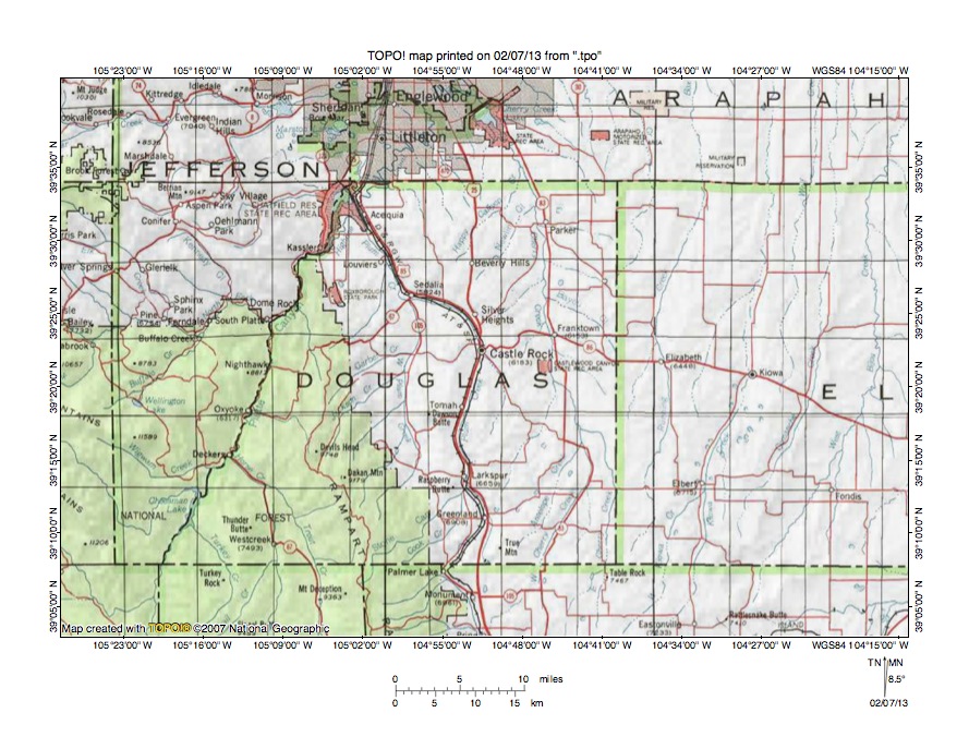
Figure 2: Detailed location map Cherry Creek-Plum Creek drainage divide area. United States Geological Survey map digitally presented using National Geographic Society TOPO software.
Figure 2 provides a detailed location map for the Cherry Creek-Plum Creek drainage divide area in Douglas County, Colorado. County lines are shown and Douglas County is labeled. The south half of the Denver metropolitan area can be seen straddling the north edge of figure 2. Green colored areas are National Forest lands, which in Colorado are generally located in mountain regions. Castle Rock is a town located near the center of figure 2 and Larkspur is located south of Castle Rock. The Rampart Range is the mountain range west of Larkspur and is a southern extension of the Colorado Front Range, which continues in a north direction on the west side of the Denver metropolitan area. The South Platte River flows in a north-northeast direction from the south edge of figure 2 (near southwest corner) on the west side of the Rampart Range to the towns of Deckers and South Platte and then to the Chatfield Reservoir State Recreation Area before flowing into the Denver metropolitan area and to the north edge of figure 2. East Cherry Creek originates just south of the southeast corner of Douglas County and flows in a north and north-northwest direction to join north oriented West Cherry Creek and to form north oriented Cherry Creek, which flows to Castlewood Canyon State Recreation Area and then to Franktown and Parker before turning in a north-northwest direction to flow into the Denver metropolitan area and to join the South Platte River north of figure 2. East Plum Creek headwaters originate in the Rampart Range and flow in northeast and north directions to Larkspur. East Plum Creek flows in a north direction from Larkspur to Castle Rock and then in a northwest direction to join West Plum Creek at Sedalia and to form north-northwest oriented Plum Creek, which joins the South Platte River at Chatfield Reservoir State Recreation Area. West Plum Creek headwaters and tributaries also originate in the Rampart Range and flow in northeast directions to form and/or join north oriented West Plum Creek, which flows just east of the Rampart Range to join East Plum Creek at Sedalia and to form north-northwest oriented Plum Creek. West of the northeast oriented East Plum Creek headwaters is north and northwest oriented Trout Creek, which joins the South Platte River at Deckers. Today the Rampart Range forms a massive barrier between the north-oriented Trout Creek-South Platte River drainage route to the west and the Plum Creek drainage route to the east, although that barrier was probably just emerging as drainage routes in the region were developing.
Cherry Creek-Plum Creek drainage divide area

Figure 3: Cherry Creek-Plum Creek drainage divide area. United States Geological Survey map digitally presented using National Geographic Society TOPO software.
Figure 3 provides a topographic map of Cherry Creek-Plum Creek drainage divide area. The map contour interval for figure 3 is 10 meters in the north and 50 meters in the south. Cherry Creek flows in a north direction near the east edge of figure 3. North of figure 3 Cherry Creek flows in a north and north-northwest direction to join the north-northeast oriented South Platte River at Denver. Northeast oriented Cherry Creek tributaries include Happy Canyon Creek, Newlin Gulch, Lemon Gulch, and Scott Gulch. East Plum Creek flows in a northwest direction from the south center edge of figure 3 to Sedalia where it joins north-northwest oriented West Plum Creek (not labeled in figure 3) to form north-northwest oriented Plum Creek, which flows to Chatfield Reservoir (seen straddling the west edge of figure 3) and the north-northeast oriented South Platte River (west of figure 3). Shallow through valleys cross the drainage divide between the northeast-oriented Cherry Creek valley and the northwest oriented East Plum Creek valley. For example a through valley defined by one 50-meter contour line on each side links the north-northeast oriented Happy Canyon Creek headwaters valley with the valley of a south oriented tributary to northwest oriented East Plum Creek. To the southeast a similar through valley links the northeast oriented Newlin Gulch headwaters valley with the valley of a southwest oriented East Plum Creek tributary. Continuing in a south direction additional through valleys link the northeast oriented Lemon Gulch and Scott Gulch valleys with the East Plum Creek valley. These through valleys provide evidence of what were probably southwest oriented flood flow channels moving floodwaters to a south oriented flood flow channel on the present day north oriented East Plum Creek alignment (south of figure 3). Reversals of flood flow caused by headward erosion of the much deeper north-northeast oriented South Platte River valley and perhaps by crustal warping that was raising regions to the south of figure 3 reversed the south oriented flood flow and created the present day north oriented drainage routes.
Detailed map of Happy Canyon-East Plum Creek drainage divide area

Figure 4: Detailed map of Happy Canyon-East Plum Creek drainage divide area. United States Geological Survey map digitally presented using National Geographic Society TOPO software.
Figure 4 provides a detailed topographic map of the Happy Canyon-East Plum Creek drainage divide area seen in less detail in figure 3. The map contour interval for figure 4 is 20 feet. Newlin Gulch originates in the northeast corner of section 16 (near south center edge of figure 4) and drains in an east-northeast and northeast direction to the east edge of figure 4 (near northeast corner). East and north of figure 4 Neewlin Gulch drains to north oriented Cherry Creek, which is located east of figure 4. Happy Canyon Creek originates in the west half of section 9 and drains in a north and northeast direction to the north center edge of figure 4. North of figure 4 Happy Canyon Creek flows to north oriented Cherry Creek. The south oriented stream originating near Riley Hill in section 5 and flowing through sections 8 and 17 to reach the south edge of figure 4 is a tributary to northwest oriented East Plum Creek, which is located south of figure 4. A hill in the Golf Course in section 9 reaches an elevation of 6674 feet. Wildcat Point on Riley Hill (in section 5) rises to more than 6600 feet. Between Wildcat Point and the Golf Course elevations along the Happy Canyon Creek-East Plum Creek drainage divide drop with the lowest elevations in the southwest quadrant of section 4 being between 6440 and 6460 feet. This drop in elevations suggests a former valley crossed the present day drainage divide with the valley at its deepest point being at least 140 feet deep. An even deeper through valley near the highway intersection straddling the border between sections 10 and 15 links the Newlin Gulch valley with the valley of a southwest oriented tributary to East Plum Creek. While not seen in figure 4 elevations along the drainage divide just south of figure 4 exceed 6700 feet suggesting the Newlin Gulch-East Plum Creek through valley is more than 230 feet deep. These through valleys are water-eroded valleys, although based on evidence seen in figure 4 it is difficult to tell which way the water was flowing and a case could be made for south oriented flow as well as for north oriented flow. Based on evidence from surrounding drainage divide areas the through valleys were probably eroded by south oriented flood flow moving from the present day north oriented Cherry Creek alignment to the present day north oriented East Plum Creek alignment. Flood flow on the Cherry Creek and East Plum Creek alignments was subsequently reversed to create north oriented drainage routes and it is possible reversed flood flow moved in north directions on the East Plum Creek to the northeast oriented Cherry Creek tributary valleys. In the latter situation reversed flood flow on the East Plum Creek alignment captured large volumes of from south and southeast oriented flood flow still moving across the what was at that time must have been an emerging Rampart Range (west of figure 4).
McMardo Gulch-East Plum Creek drainage divide area

Figure 5: McMardo Gulch-East Plum Creek drainage divide area. United States Geological Survey map digitally presented using National Geographic Society TOPO software.
Figure 5 illustrates a topographic map of the McMardo Gulch-East Plum Creek drainage divide area south and east of figure 3 and includes an overlap area with figure 3. The map contour interval for figure 5 is 50 meters. Castle Rock is located near the center of figure 5. East Plum Creek flows in a north-northeast direction from the south edge of figure 5 (slightly west of center) to Castle Rock and then in a northwest direction to Sedalia near the northwest corner of figure 5. West Plum Creek flows in a north direction from the south edge of figure 5 (near southwest corner) to join East Plum Creek near Sedalia and to form north-northwest oriented Plum Creek, which flows to the northwest corner of figure 5. Sellers Gulch is a north and north-northwest oriented tributary draining from the south center edge of figure 5 to join East Plum Creek at Castle Rock. Tributaries to West Plum Creek from the east are oriented in north-northwest and northwest directions. Cherry Creek flows in a north-northwest direction from the south edge of figure 5 (near southeast corner) to the Castlewood Canyon State Recreation Area and then flows in a north direction to the north edge of figure 5 (east half). Northeast oriented Cherry Creek tributaries seen include Lemon Gulch, Scott Gulch, McMardo Gulch, Mitchell Gulch, and Willow Creek. McMardo Gulch and Mitchell Gulch have north oriented headwaters. Through valleys defined by one 5-meter contour line link northwest oriented West Plum Creek tributary valleys with the north-northeast oriented East Plum Creek valley. Likewise through valleys defined by one 50-meter contour line on a side link the Scott Gulch and McMardo Gulch valleys with the north oriented East Plum Creek valley. These through valleys are water-eroded valleys and were probably eroded by south oriented flood flow diverging from flood flow channels on the present day north oriented West Plum Creek and Cherry Creek alignment to flow to a south oriented flood flow channel on the present day north oriented East Plum Creek alignment. Flood flow directions were subsequently reversed when headward erosion of the deep north-northeast oriented South Platte River valley (north and west of figure 5) beheaded and reversed the south oriented flood flow channels crossing the region in figure 5. It is possible reversed flood flow crossing figure 5 captured significant volumes of southeast oriented flood flow moving west and south of the actively eroding north-northeast South Platte River valley head (which was eroding headward on what had been a south-southwest oriented flood flow channel). If such captures of flood flow occurred then north oriented floodwaters may have continued to erode the region seen in figure 5.
Detailed map of Willow Creek-Lake Gulch drainage divide area

Figure 6: Detailed map of Willow Creek-Lake Gulch drainage divide area. United States Geological Survey map digitally presented using National Geographic Society TOPO software.
Figure 6 provides a reduced size detailed topographic map of the Willow Creek-Lake Gulch drainage divide area seen in less detail in figure 5. The map contour interval for figure 6 is 20 feet. West Plum Creek flows in a north and north-northeast direction near the west edge of figure 6. East Plum Creek flows in a north-northeast direction from the south center edge of figure 6 to Castle Rock at the north edge of figure 6. Sellers Gulch is the north-northeast and north-northwest oriented drainage route extending from the south edge of figure 6 (east half) to join East Plum Creek at Castle Rock. Willow Creek is the north-northeast oriented stream flowing across the southeast corner of figure 6 and west of figure 6 Willow Creek flows to north oriented Cherry Creek. Dawson Butte is the high butte located near the south edge of the southwest quadrant of figure 6 and appears to be composed of some type of erosion resistant rock. The highest point on Dawson Butte has an elevation of 7481 feet. An unnamed butte near the north center edge of figure 6 also appears to be composed of erosion resistant rock and reaches an elevation of 6810 feet. South of Castle Rock there is another similar butte, which has quarries on its top and which reaches an elevation of more than 6700 feet. East of Sellers Gulch the region appears to be underlain by the erosion resistant rock with the surface elevation decreasing from approximately 6800 feet near the southeast corner of figure 6 to approximately 6600 feet near the northeast corner of figure 6. Whatever the erosion resistant rock is it has been removed from the region between West and East Plum Creeks with the exception of Dawson Butte and the unnamed butte to the north. Today a broad through valley links north-northwest and northwest oriented West Plum Creek tributary valleys originating between the two buttes with the north-northeast oriented East Plum Creek valley. Lowest points along the drainage divide today are between 6640 and 6660 feet and are located in the northeast quadrant of section 32 (near Dawson Butte). The buttes provide evidence much of the region seen in figure 6 has been stripped of several hundred feet or more of bedrock material that once covered the region. Today the region is crossed by north oriented drainage routes, although those north oriented drainage routes were probably formed by reversals of diverging and converging south oriented flood flow channels. The stripping of the figure 6 region was probably done primarily by the south oriented floodwaters, although some stripping may have continued to take place after the flood flow channels had been systematically reversed to flow in north directions, especially if the newly formed north oriented drainage routes captured floodwaters from west of the emerging Rampart Range.
Lake Gulch-East Plum Creek drainage divide area
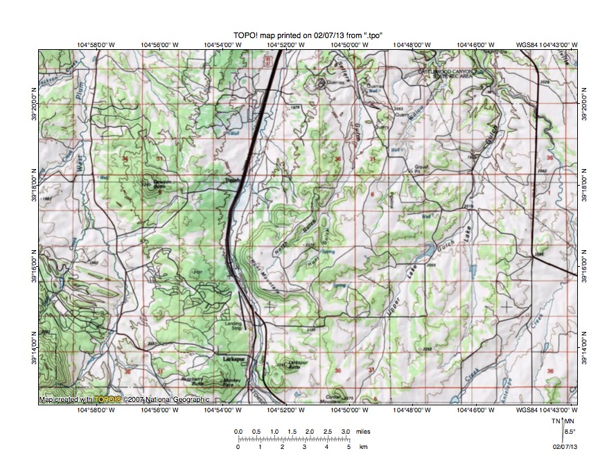
Figure 7: Lake Gulch-East Plum Creek drainage divide area. United States Geological Survey map digitally presented using National Geographic Society TOPO software.
Figure 7 illustrates a topographic map of the Lake Gulch-East Plum Creek drainage divide area south of figure 5 and there is an overlap area with figure 5. The map contour interval for figure 7 is 50 meters. West Plum Creek is formed at the confluence of a north-northeast oriented tributary (bear Creek) and an east, north-northeast, and north-northwest oriented tributary (Stark Creek) near the west center edge of figure 7 and then flows in a north direction to the north edge of figure 7 (near northwest corner). East and northeast oriented West Plum Creek tributaries are flowing from the Rampart Range, which is located west of figure 7. Corner Mountain is a butte located near the south center edge of figure 7. Larkspur is the town located west of Corner Mountain. East Plum Creek flows in a northeast direction from the Rampart Range (south and west of figure 7) to Larkspur and then flows in a north and north-northeast direction to the north edge of figure 7 (slightly west of center). West Cherry Creek flows in a north direction from the east edge of figure 7 (south of center) to join north-northwest oriented Cherry Creek, which then flows through the Castlewood Canyon State Recreation Area to the north edge of figure 7 (east half). Antelope Creek is the north-northeast oriented Cherry Creek tributary flowing across the southeast corner of figure 7 and Haskel Creek is the northeast oriented Antelope Creek tributary near the south edge of figure 7. Lake Gulch is a north and north-northeast tributary joining Cherry Creek at the Castlewood Canyon State Recreation Area and Upper Lake Gulch is a north-northeast oriented Lake Gulch tributary. Dawson Butte is located north of the west center area of figure 7 and reaches an elevation of 2280 meters. Buttes near Larkspur include Raspberry Butte and Larkspur Butte. Raspberry Butte exceeds 2350 meters in height and Larkspur Butte reaches 2297 meters. These buttes appear to be composed of erosion resistant rock. Hunt Mountain (north of Larkspur Butte) also appears to be composed of erosion resistant rock and reaches an elevation of between 2200 and 2250 meters. These buttes and other high areas suggest intervening areas have been deeply eroded. While today all drainage routes seen in figure 7 are oriented in north directions erosion of the region was probably initiated by south oriented flood flow. South oriented flood flow channels were subsequently beheaded and reversed to create the north oriented drainage routes seen today and the newly formed north oriented drainage routes probably captured significant flood flow still moving in south directions west of the Rampart Range, which is located west of figure 7. The flood flow reversal in the region seen in figure 7 may have been aided by crustal warping, which may have been raising regions south of figure 7.
Detailed map of Upper Lake Gulch-East Plum Creek drainage divide area
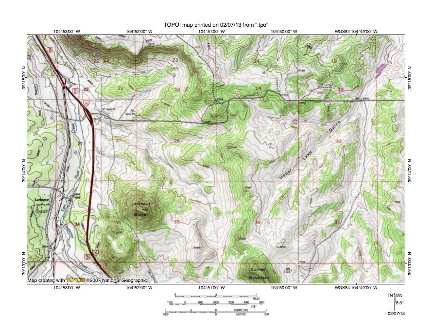
Figure 8: Detailed map of Upper Lake Gulch-East Plum Creek drainage divide area. United States Geological Survey map digitally presented using National Geographic Society TOPO software.
Figure 8 provides a detailed topographic map of the Upper Lake Gulch-East Plum Creek drainage divide area seen in less detail figure 7. The map contour interval for figure 8 is 20 feet. East Plum Creek flows in a north direction from the south edge of figure 8 (near southwest corner) to the northwest corner of figure 8. South and west of figure 8 East Plum Creek flow in a northeast direction through a deep canyon crossing the Rampart Range (see figure 10). Carpenter Creek is the northwest oriented tributary joining East Plum Creek south of the town of Larkspur and is seen again in figures 9 and 10. Upper Lake Gulch originates in section 36 and drains in a north-northeast and northeast direction to the northeast corner of figure 8. Larkspur Butte is located the west half of section 35 and reaches an elevation of 7535 feet, which is almost 900 feet higher than the East Plum Creek valley floor in section 34 just to the west. Corner Mountain is located just east of the south center edge of figure 8 and reaches an elevation of 7455 feet. The south edge of Hunt Mountain can be seen in sections 22 and 23 near the north edge of the northwest quadrant of figure 8. Elevations on Hunt Mountain exceed 7260 feet and are approximately 700 feet higher than the East Plum Creek valley floor elevation near the northwest corner of figure 8. A west-to-east oriented through valley in the north half of section 25 (the unlabeled section near the center of figure 8) links a west oriented East Plum Creek tributary valley with an east oriented Upper Lake Gulch tributary valley. The through valley floor elevation at the drainage divide is between 7080 and 7100 feet suggesting the through valley is at least 160 feet deep. The through valley was probably eroded by south oriented flood flow moving from the present day north oriented East Plum Creek alignment to reversed flood flow on the present day north-northeast oriented Upper Lake Gulch and Lake Gulch and north oriented Cherry Creek alignments. The flood flow was making a U-turn in the region seen in figure 8. Subsequently flood flow on the East Plum Creek alignment was beheaded and reversed and the reversed flood flow on the East Plum Creek alignment probably captured flood flow still moving in south directions west of the Rampart Range and that captured flood flow helped erode the East Plum Creek valley, which is today approximately 500 feet lower in elevation than the west-to-east oriented through valley in section 25.
Carpenter Creek-West Cherry Creek drainage divide area
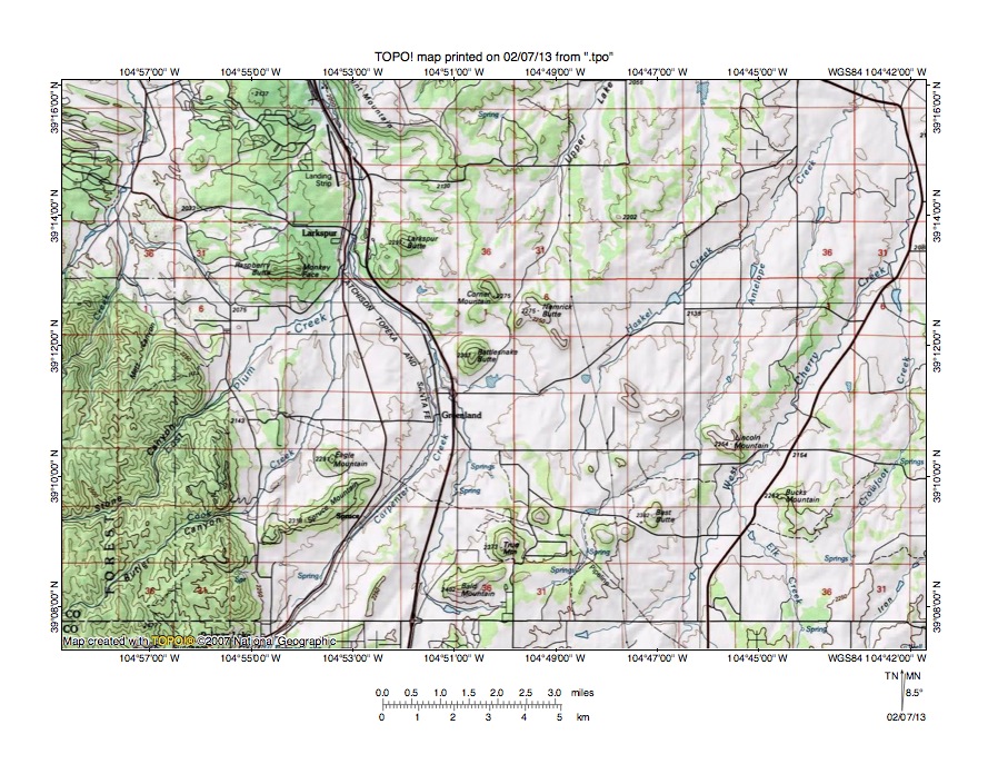
Figure 9: Carpenter Creek-West Cherry Creek drainage divide area. United States Geological Survey map digitally presented using National Geographic Society TOPO software.
Figure 9 illustrates topographic map of the Carpenter Creek-West Cherry Creek drainage divide area south and east of figure 7 and there is an overlap area with figure 7. The map contour interval for figure 9 is 50 meters. The east margin of the Rampart Range is located along the west margin of the southwest quadrant of figure 9. Stark Creek flows in a north-northeast and north direction across the northwest corner of figure 9 and north of figure 9 joins north oriented West Plum Creek. West of figure 9 Stark Creek flows in an east, north, and northeast direction from the crest of the Rampart Range (see figure 10). East Plum Creek flows in a northeast direction from the west edge of figure 9 (south half) through Stone Canyon and then to Larkspur where it turns to flow in a north direction to the north edge of figure 9 (west half). Cook Creek flows in a northeast direction from near the southwest corner of figure 9 through Butler Canyon and then turns to flow in a north direction to join East Plum Creek south of Larkspur. Carpenter Creek flows in a northeast direction from the south edge of figure 9 (west half-near east edge of Rampart Range) to Greenland and then turns to flow in a north-northwest direction to join East Plum Creek near Larkspur. West Cherry Creek flows in a north-northeast and north direction from the south edge of figure 9 (east half) to the north edge of figure 9 (near northeast corner). Haskel Creek originates in the south center area of figure 9 and flows in a north-northeast and northeast direction to join West Cherry Creek near the northeast corner of figure 9. Assuming the buttes east of the Rampart Range are erosional residuals and not constructional landforms the buttes provide evidence of deep regional erosion and of through valleys linking the various drainage routes. Elevations of the buttes above the surrounding landscape range from two to six 50-meter contour intervals suggesting that between 100 and 300 meters of bedrock material has been removed from the intervening areas. While erosion of the region probably originated as south oriented floodwaters flowed across the area the flood flow direction was systematically reversed from east to west as headward erosion of the deep South Platte River valley beheaded and reversed the south oriented flood flow channels. Flood flow channels east of the Rampart Range were reversed while floodwaters still moved in south directions further to the west. Reversed flood flow channels east of the Rampart Range captured flood flow from further to the west and that captured flood flow helped erode the deep north oriented Plum Creek and Cherry Creek valleys illustrated in this essay. Figure 10 illustrates the region west of figure 9 to show where the captured floodwaters came from.
Trout Creek-Carpenter Creek drainage divide area

Figure 10: Trout Creek-Carpenter Creek drainage divide area. United States Geological Survey map digitally presented using National Geographic Society TOPO software.
Figure 10 provides a topographic map of the Trout Creek-Carpenter Creek drainage divide area west and slightly south of figure 9 and there is an overlap area with figure 9. The map contour interval for figure 10 is 50 meters. The crest of the Rampart Range extends in a north-to-south direction across figure 10 (just west of center). Larkspur is located near the northeast corner of figure 10. Palmer Lake is located near the southeast corner of figure 10. Monument Creek flows in a northeast direction from the south edge of figure 10 (east half) to Palmer Lake and then makes an abrupt turn to flow in a southeast direction to the south edge of figure 10 (near southeast corner). South and east of figure 10 Monument Creek flows in a south direction to join south oriented Fountain Creek, which flows to east oriented Arkansas River, which eventually flows directly to the Mississippi River. Carpenter Creek originates just north of Palmer Lake and flows in a northeast direction to the east center edge of figure 10. East of figure 10 Carpenter Creek turns to flow in a northwest direction to join East Plum Creek near Larkspur. East Plum Creek originates along the Rampart Range crest just north of the south center edge of figure 10 and flows in a north direction through Saylor Park before turning in a northeast direction to flow through Stone Canyon and then to Larkspur where it turns to flow in a north direction to the north edge of figure 10. North of figure 10 East Plum Creek flows in a north and northwest direction to join West Plum Creek and to form north-northwest oriented Plum Creek, which flows to the north-northeast oriented South Platte River. Stark Creek originates on the Rampart Range crest just north of the center of figure 10 and flows in an east, north, and northeast direction to the north edge of figure 10 (east half). North of figure 10 Stark Creek flows to north oriented West Plum Creek, which joins East Plum Creek to form north-northwest oriented Plum Creek, which flows to the north-northeast oriented South Platte River. Trout Creek flows in a north and north-northwest direction from the south edge of figure 10 (west half) to the west edge of figure 10 (north half). West of figure 10 Trout Creek joins other streams to form northwest oriented Horse Creek, which flows to the north-northeast oriented South Platte River. Trout Creek tributaries are interesting because they include south and southwest oriented barbed tributaries in the northwest quadrant of figure 10 and tributary valleys linked by shallow through valleys across the Rampart Range crest with the Stark Creek and East Plum Creek headwaters valleys. The barbed tributaries provide evidence the Trout Creek valley was once used by south oriented flood flow with the direction of flood flow being subsequently reversed to create the north oriented Trout Creek drainage route seen today. The through valleys provide evidence floodwaters at one time flowed from a south oriented flood flow channel on the TRout Creek alignment (although at much higher elevation the Trout Creek today) in east directions to reversed flood flow channels on the present day north oriented West Plum Creek and East Plum Creek drainage routes. The Rampart Range probably was emerging when floodwaters flowed across it. Otherwise the east oriented flood flow channels mean the Trout Creek valley has been lowered by almost 400 meters since that time and deep erosion of the region east of the Rampart Range is also implied. While today east oriented flood flow across the Rampart Range appears impossible, ice sheet related crustal warping was taking place as floodwaters flowed across the region and emergence of the Rampart Range probably occurred at that time.
Additional information and sources of maps studied
This essay has provided only a sample of the detailed topographic map evidence supporting the flood erosion interpretation. Many additional illustrations could be provided. Readers are encouraged to look at mosaics of detailed topographic maps to see the abundance of available data. Maps used in this study were created and published by the United States Geologic Survey and can be obtained directly from the United States Geological Survey and/or from dealers offering United States Geological Survey maps. Hard copy maps can also be observed at United States Geological Survey map depositories, which are located throughout the United States and elsewhere. Illustrations used here were created using National Geographic Society TOPO software and digital map data. TOPO software and map data can be obtained from the National Geographic Society and/or dealers offering National Geographic Society digital map data.

Leave a comment