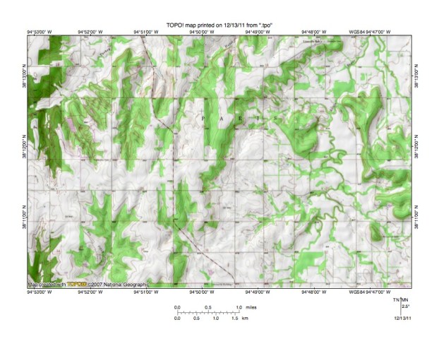
Hazel Branch valley in Linn County, Kansas
Introduction:
- This page is written to respond to Brad’s question about the Hazel Branch valley in Linn County, Kansas. The question is asked as a comment on the Marais des Cygnes River-Little Osage River drainage divide area landform origins in Miami, Linn, and Bourbon Counties, Kansas, USA essay on my Missouri River drainage basin landform origins research project web site and relates to figure 6 in that essay. Figure A below is a more detailed topographic map of the region Brad asks about.
Figure A: Detailed topographic map Big Sugar Creek-Little Sugar Creek drainage divide area in Hazel Branch region. United States Geological Survey map digitally presented using National Geographic Society TOPO software.
Figure A description:
- Hazel Branch originates as north-oriented gullies in the section 26 northeast quadrant and then drains in a north-northeast direction across the section 23 southeast corner and the section 24 northwest corner to enter section 13 where the word “Hazel” can be seen. Turkey Creek flows in a northeast direction across section 15 in the figure 1 northwest quadrant (west of Hazel Branch). North of the figure 1 map area both Turkey Creek and Hazel Branch flow to east-oriented Big Sugar Creek. South of the figure 1 map area is east-oriented Little Sugar Creek and southeast and south oriented drainage in the figure 1 southwest quadrant and south center area flows to Little Sugar Creek. As seen in the essay’s figure 6 east of the figure A map area Little Sugar Creek turns to flow in a north direction to join Big Sugar Creek, which then joins the southeast oriented Marais des Cygnes River. Brad’s question also refers to the unnamed north oriented Turkey Creek tributary is sections 23 and 14 (located between Hazel Branch and Turkey Creek). Note how west of that unnamed Turkey CReek tributary there are several other shorter unnamed northwest, north-northwest, and north oriented Turkey Creek tributaries.
Answer to Brad’s question:
- To answer Brad’s question first look at the drainage divide between the north-oriented Big Sugar Creek tributaries (including the north-oriented Turkey Creek and Hazel Branch tributaries) and the south-oriented Little Sugar Creek tributaries. The figure A contour interval is 10 feet and by following the drainage divide it is possible to see shallow north-south oriented through valleys linking the north oriented valleys with the south oriented valleys. Most of these shallow through valleys are defined by a single 10-foot contour line on each side. The through valleys were eroded by south-oriented flood flow channels moving flood waters to what was at one time the actively eroding east oriented Little Sugar Creek valley south of the figure A map area. At that time the deep east oriented Big Sugar Creek valley north of figure A did not exist, nor did the Marais des Cygnes valley further to the north exist. Headward erosion of what was then a much deeper east oriented Big Sugar Creek valley and its northeast oriented tributary valleys (much deeper than the south oriented flood flow channels) north of the figure A map area beheaded the south oriented flood flow channels in sequence from east to west. Flood waters on the north ends of the beheaded flood flow channels then reversed flow direction to erode north-oriented valleys. Because the flood flow channels were beheaded and reversed one at a time, from east to west, each newly reversed flood flow channel could capture flood waters from flood flow channels further to the west. The volume of captured flood waters moving to a newly reversed flood flow channel determined how deep the north oriented valley was eroded. Factors influencing the volume of captured flood flow included the rate at which the flood flow channels were being beheaded and probably also included bedrock characteristics not determinable from topographic map evidence.


Leave a comment