
Abstract:
This essay uses topographic map evidence to interpret landform origins in the South Platte River-Plum Creek drainage divide area in the Rampart Range, Colorado. The South Platte River flows west of the Rampart Range in a north-northeast direction to the north end of the Rampart Range and then flows in a northeast direction on the Colorado Piedmont east of the Colorado Front Range before turning in a southeast, east, and northeast direction to flow into western Nebraska to join the Platte River with water eventually flowing to the Missouri and Mississippi Rivers. Plum Creek is formed at the confluence of north oriented West Plum Creek and north and northwest oriented East Plum Creek, which flow east of the Rampart Range on the west margin of the Colorado Piedmont. Plum Creek flows in a north-northwest direction to join the north-northeast oriented South Platte River at the north end of the Rampart Range. West and East Plum Creek headwaters and tributaries originate in the Rampart Range and flow in northeast directions to join north oriented West and East Plum Creeks. Trout Creek is a north and northwest oriented stream west of the Rampart Range and west of the East and East Plum Creek headwaters and flows to northwest oriented Horse Creek, which flows to the north-northeast oriented South Platte River. Southeast, southwest, and south oriented streams flow to some of the north oriented trunk streams as barbed tributaries and through valleys have been eroded across drainage divides, including the crest of the Rampart Range. The present day north oriented drainage routes were initiated as south oriented flood flow channels at a time when the Rampart Range was just beginning to emerge and the Rampart Range emerged as floodwaters flowed across it and around it. Floodwaters were derived from the western margin of a thick North American ice sheet and flowed from western Canada to and across Colorado. Headward erosion of the east oriented Arkansas River valley south of the study area captured the south oriented flood flow and south oriented valleys eroded headward from the newly eroded valley along the anastomosing south oriented flood flow routes. Headward erosion of the deep South Platte River valley across the Colorado Piedmont subsequently beheaded the south oriented flood flow channels in sequence from east to west with floodwaters on north ends of beheaded flood flow channels reversing flow direction to create north oriented South Platte River tributary drainage routes. Because flood flow channels were beheaded and reversed one at a time and because flood flow channels were anastomosing newly reversed flood flow channels captured south oriented flood flow still moving in flood flow channels further to the west. Such captures resulted in floodwaters making U-turns as the flood flow moved from south oriented flood flow channels to north oriented flood flow channels. Evidence for such U-turns can be seen in the crossing the Rampart Range as well as evidence for south oriented flood flow routes along and adjacent to the Rampart Range crest.
Preface
The following interpretation of detailed topographic map evidence is one of a series of essays describing similar evidence for all major drainage divides contained within the Missouri River drainage basin and for all major drainage divides with adjacent drainage basins. The research project is interpreting evidence in the context of a previously unexplored deep glacial erosion paradigm, which is fundamentally different from most commonly accepted North American glacial history interpretations. Project essays are listed on the sidebar category list under their appropriate Missouri River tributary drainage basin, Missouri River segment drainage basin (by state), and/or state in which the Missouri River drainage basin is located.
Introduction
The purpose of this essay is to use topographic map interpretation methods to explore the South Platte River-Plum Creek drainage divide area landform origins in the Rampart Range, Colorado. Map interpretation methods can be used to unravel many geomorphic events leading up to formation of present-day drainage routes and development of other landform features. While each detailed topographic map feature provides detailed evidence to be explained, the solution must be consistent with explanations for adjacent area map evidence as well as solutions to big picture map evidence puzzles. I invite readers to improve upon my solutions and/or to propose alternate solutions that better explain evidence and are also consistent with adjacent map area and big-picture evidence. Readers may do so either by making comments here or by writing and publishing their own essays and then by leaving a link to those essays in a comment here.
This essay is also exploring a new geomorphology paradigm in which erosional landforms are interpreted as evidence left by immense glacial melt water floods. Implied in that interpretation is the immense floods were derived from a thick North American ice sheet that created a deep “hole” in the North American continent and also melted fast. The previously unexplored paradigm being tested in this and other Missouri River drainage basin landform origins research project essays is a thick North American ice sheet, comparable in thickness to the Antarctic ice sheet, occupied the North American region usually recognized to have been glaciated, and through its weight and erosive actions created a deep North American “hole”. The southwestern rim of that deep “hole” is today preserved in the high Rocky Mountains. The ice sheet through its weight and deep erosion (and perhaps deposition along major south-oriented melt water flow routes) caused significant crustal warping and tectonic change, through its action of melting fast produced immense floods that flowed across the continent, and through its action of melting fast systematically opened up space in the ice sheet created “hole” so headward erosion of newly developed north-oriented drainage systems captured immense south-oriented melt water floods and diverted immense melt water floods north into space the ice sheet had once occupied.
If this previously unexplored paradigm is correct the geographic region explored by this essay should contain evidence of immense floods that were captured by headward erosion of new valley systems so as to cause the floods to flow in a different direction. Ability of this previously unexplored paradigm to explain South Platte River-Plum Creek drainage divide area landform evidence in the Rampart Range, Colorado will be regarded as evidence supporting the “thick ice sheet that melted fast” paradigm.
South Platte River-Plum Creek drainage divide area location map

Figure 1: South Platte River-Plum Creek drainage divide area location map (select and click on maps to enlarge). National Geographic Society map digitally presented using National Geographic Society TOPO software.
Figure 1 provides a location map for the South Platte River-Plum Creek drainage divide area in the Rampart Range, Colorado and illustrates a region in central Colorado. Elevenmile Canyon Reservoir is located in the southwest quadrant of figure 1. The South Platte River flows in a southeast direction from Hartsel to Elevenmile Canyon Reservoir and then turns to flow in a north-northeast direction to Denver and the north edge of figure 1 (slightly east of center). North of figure 1 the South Platte River turns to flow in a southeast, east, and northeast direction to flow into western Nebraska with water eventually reaching the Platte, Missouri, and Mississippi Rivers. The Colorado Front Range is located west of Denver and east of Denver is the Colorado Piedmont. South of Denver the southern extension of the Front Range, which is known as the Rampart Range, is located between the north-northeast oriented South Platte River valley and the highway between Denver and Colorado Springs, which is located along the west margin of the Colorado Piedmont. The north oriented stream flowing to and adjacent to that highway between Larkspur and Castle Rock is East Plum Creek. South of Larkspur East Plum Creek flows in a northeast direction from the Rampart Range. North of Castle Rock East Plum Creek turns to flow in a northwest direction to Sedalia where it is joined by north oriented West Plum Creek (not shown in figure 1) to form north-northwest oriented Plum Creek, which joins the north-northeast oriented South Platte River south of Denver. Palmer Lake is located south of Larkspur and the south oriented stream flowing from near Palmer Lake to the Colorado Springs and the south edge of figure 1 flows to the east oriented Arkansas River, which eventually flows directly to the Mississippi River. The unnamed north and northwest oriented South Platte River tributary west of Palmer Lake is actually two streams, with north oriented Trout Creek flowing to northwest oriented Horse Creek, which flows to the north-northeast oriented South Platte River. The South Platte River-Plum Creek drainage divide area investigated in this essay is located north of the East Plum Creek headwaters, west of West Plum Creek, and east of Trout and Horse Creeks and the South Platte River.
While difficult to visualize based on present day topography drainage routes in Colorado developed during immense south oriented melt water floods from the western margin of a thick North American ice sheet. Floodwaters flowed from western Canada to and across Colorado at a time when ice sheet related crustal warping was raising Colorado and Colorado mountain ranges and when deep valleys were eroding headward into Colorado to capture the gigantic south oriented melt water floods. Headward erosion of the east oriented Arkansas River first captured the south oriented flood flow in Colorado (south of figure 1) and south oriented tributary valleys eroded headward from the newly eroded Arkansas River valley. At that time Colorado mountain ranges were just beginning to emerge and the south oriented floodwaters flowed across what are today massive mountain barriers and eroded deep valleys into the emerging mountain masses. Headward erosion of the deep southeast, east, and northeast oriented South Platte River valley (north of the northeast quadrant of figure 1) into northeast Colorado from western Nebraska subsequently beheaded south oriented flood flow channels on the Colorado Piedmont. Floodwaters on the north ends of the beheaded flood flow channels reversed flow direction to flow to the much deeper southeast, east, and northeast oriented South Platte River valley and to create what are today north oriented South Platte River tributary drainage routes (e.g. Kiowa and Bijou Creeks) and the north-northeast oriented South Platte River drainage route. Headward erosion of the deep South Platte River valley knick point along the newly reversed north-northeast oriented South Platte River drainage route beheaded and reversed what had been southeast and south oriented flood flow channels and created the north and northwest oriented Plum Creek and Trout Creek-Horse Creek drainage routes. Reversed flood flow on the north-northeast oriented South Platte River drainage route also captured significant south and southeast oriented flood flow channels from further to west (see southeast oriented South Platte River headwaters and tributaries in the southwest quadrant of figure 1). Headward erosion of the southwest oriented Colorado River valley (north of the northwest corner of figure 1) beheaded and reversed those south and southeast oriented flood flow channels to create the present day east-west continental and north and northwest oriented Colorado River tributary drainage routes (e.g. Blue River seen in northwest corner of figure 1).
Detailed location map for South Platte River-Plum Creek drainage divide area

Figure 2: Detailed location map for South Platte River-Plum Creek drainage divide area. United States Geological Survey map digitally presented using National Geographic Society TOPO software.
Figure 2 provides a detailed location map for the South Platte River-Plum Creek drainage divide area in the Rampart Range, Colorado. Green colored areas are National Forest lands, which in Colorado are usually located in mountain regions. The Rampart Range is labeled and is located near the eastern margin of the green colored region. Elevenmile Canyon Reservoir is located in the southwest quadrant of figure 2. The South Platte River flows in a southeast direction from the west edge of figure 2 (south half) to Elevenmile Canyon Reservoir and then makes an abrupt turn to flow in a north-northeast direction to the towns of Lake George, Deckers, Oxyoke, Nighthawk, South Platte, and then to the north center edge of figure 2. Most tributaries from the west flow in southeast directions to join the north-northeast oriented South Platte River as barbed tributaries. Tributaries to the north-northeast oriented South Platte River from the east appear to be fewer and flow in north and northwest directions and include Horse Creek and its Trout Creek tributary, which joins the South Platte River at Deckers. East Plum Creek originates in the Rampart Range just south of the Douglas County south border and flows in a northeast direction through Stone Canyon to Larkspur. From Larkspur East Plum Creek flows in a north direction to Castle Rock and then in a northwest direction to Sedalia where it is joined by north oriented West Plum Creek to form north-northwest oriented Plum Creek, which flows to the north edge of figure 2 at Louviers. North of figure 2 Plum Creek joins the north-northeast oriented South Platte River. West Plum Creek headwaters and tributaries originate in the Rampart Range (north of the East Plum Creek headwaters) and flow in northeast directions onto the Colorado Piedmont to join north oriented West Plum Creek, which then joins northwest oriented East Plum Creek at Sedalia to form north-northwest oriented Plum Creek. The north and northwest oriented South Platte River tributaries originated as southeast and south oriented flood flow channels diverging from a south-southwest oriented flood flow channel on the present day north-northeast oriented South Platte River drainage route. The south oriented flood flow channels were captured south of figure 2 by headward erosion of the deep east oriented Arkansas River valley. Subsequently headward erosion of the deep southeast, east, and northeast oriented South Platte River valley into northeast Colorado (north and east of figure 2) beheaded and reversed the south-southwest oriented flood flow channel on the present day north-northeast oriented South Platte River alignment. The reversal of flood flow on the South Platte River alignment also resulted in reversals of flood flow on the diverging southeast and south oriented flood flow channels to create the present day north-northeast oriented South Platte River drainage route and its north and northwest oriented tributary drainage routes. .
Bear Creek-Indian Creek drainage divide area
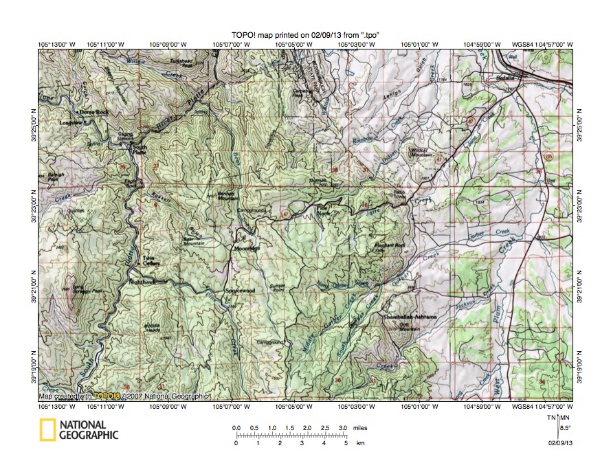
Figure 3: Bear Creek-Indian Creek drainage divide area. United States Geological Survey map digitally presented using National Geographic Society TOPO software.
Figure 3 provides a topographic map of Bear Creek-Indian Creek drainage divide area. The map contour interval for figure 3 is 50 meters. The South Platte River flows in a north-northeast and north direction from the south edge of figure 3 (near southwest corner) to the town of South Platte (in northwest quadrant of figure 3) and then turns to flow in a northeast and north direction to the north edge of figure 3 (west of center). The southeast oriented drainage route joining the South Platte River at the town of South Platte is the North Fork South Platte River. Pine Creek is the north and west oriented tributary flowing from the south edge of figure 3 (west of center) to join the South Platte River between Nighthawk and Twin Cedars. Bear Creek originates in the south center area of figure 3 and flows in a north-northwest direction to join the northeast oriented South Platte River. A north-to-south oriented through valley between the towns of Moonridge and Sprucewood links the north-northwest oriented Bear Creek valley with the north oriented Pine Creek headwaters valley. The through valley is defined by four 50-meter contour lines and was eroded by south oriented flood flow prior to the reversals of flood flow that created the north oriented South Platte River, Bear Creek, and Pine Creek drainage routes. Sedalia is located near the northeast corner of figure 3. West Plum Creek flows in a north direction from the south edge of figure 3 (near southeast corner) to Sedalia where it joins northwest oriented East Plum Creek to form north-northwest oriented Plum Creek, which flows to the north edge of figure 3. North of figure 3 Plum Creek joins the north-northeast oriented South Platte River. Indian Creek originates east of Bear Creek (and north and east of Moonridge) and flows in an east-northeast direction near Pine Nook before turning in a northeast and north-northeast direction to join Plum Creek near Sedalia. A west-to-east oriented through valley links the north-northwest oriented Bear Creek valley with the east-northeast and northeast oriented Indian Creek valley. The through valley is defined by three 50-meter contour lines and was eroded by east oriented floodwaters flowing from south oriented flood flow on the present day north oriented Bear Creek alignment to newly reversed flood flow on the Plum Creek alignment. Headward erosion of the north-northeast oriented South Platte River beheaded and reversed south oriented flood flow channels in sequence from east to west, which meant south oriented flood flow on the Plum Creek alignment was beheaded and reversed while south oriented flood flow was still moving the Bear Creek alignment further to the west. Reversed flood flow on the Plum Creek alignment captured south oriented flood flow from the Bear Creek alignment and the captured flood made a U-turn on the Indian Creek alignment as the floodwaters turned from flowing in a south direction to flowing in a north-northwest direction on the Plum Creek alignment.
Detailed map of Bear Creek-Indian Creek drainage divide area
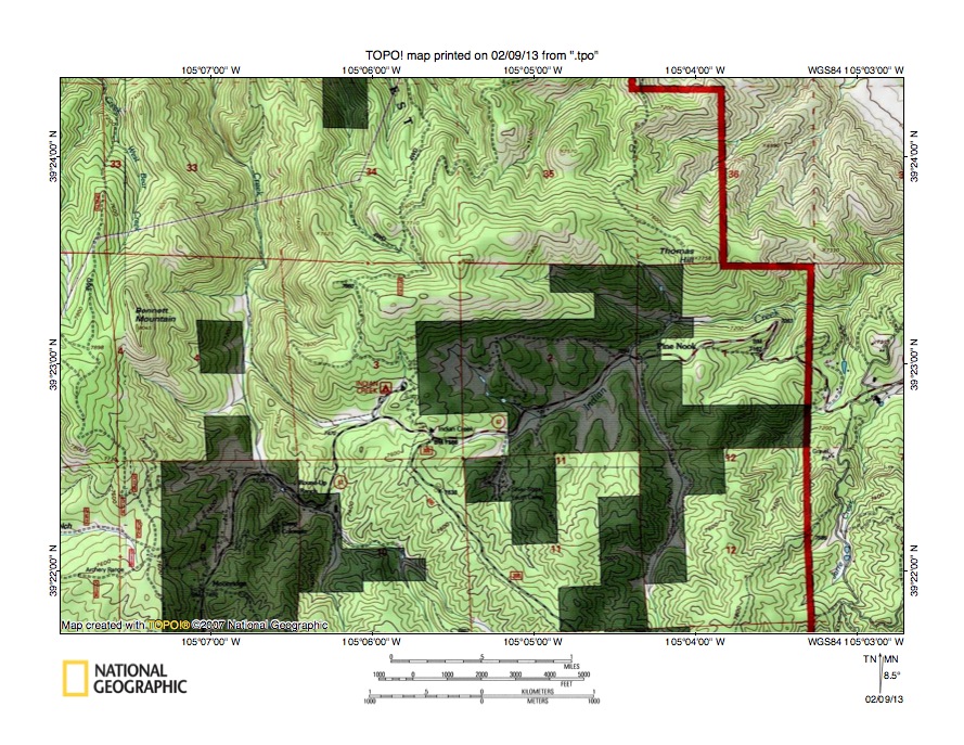
Figure 4: Detailed map of Bear Creek-Indian Creek drainage divide area. United States Geological Survey map digitally presented using National Geographic Society TOPO software.
Figure 4 provides a detailed topographic map of the Bear Creek-Indian Creek drainage divide area seen in less detail in figure 3. The map contour interval for figure 4 is 40 feet. Shading in figure 4 partially hides some of the most interesting features, but I will try to describe what figure 4 illustrates. Moonridge is a small community in section 9 (hidden in shaded area in the southwest quadrant of figure 4). Bear Creek flows in a north-northwest direction from the south edge of figure 4 (west half) to section 4 and then flows in a north direction across section 31 to the north edge of figure 4 (west half). North of figure 4 Bear Creek flows in a north-northwest direction to join the northeast and north-northeast oriented South Platte River. Indian Creek originates in the southeast corner of section 3 and flows in an east-northeast direction across sections 2 and 1 to the east edge of figure 4. East of figure 4 Indian Creek turns to flow in a northeast and north-northeast direction to join north-northwest oriented Plum Creek, which flows to the north-northeast oriented South Platte River. A west-to east oriented through valley in the southeast corner of section 3 links a west and northwest oriented Bear Creek tributary valley with the east-northeast oriented Indian Creek headwaters valley and has an elevation of 7588 feet. At Sunset Point, which is south of figure 4 (see figure 3), elevations rise to 8007 feet. Elevations in the northeast quadrant of section 3 rise to more than 8040 feet suggesting the through valley is more than 400 feet deep. The through valley was eroded by floodwaters flowing from a south oriented flood flow channel on the present day north oriented Bear Creek alignment to newly reversed flood flow on the Plum Creek alignment. Headward erosion of the north-northeast oriented South Platte River valley (on the alignment of what had been a south-southwest oriented flood flow channel) beheaded and reversed south oriented flood flow on the Plum Creek alignment before it beheaded and reversed south oriented flood flow on the Bear Creek alignment. For a short period of time floodwaters made a U-turn in section 3 as floodwaters turned from flowing in a south direction on the Bear Creek alignment to flowing in an east-northeast, northeast, and north-northeast direction on the Indian Creek alignment and then in a north-northwest direction on the Plum Creek alignment.
Sugar Creek-Jackson Creek drainage divide area

Figure 5: Sugar Creek-Jackson Creek drainage divide area. United States Geological Survey map digitally presented using National Geographic Society TOPO software.
Figure 5 illustrates a topographic map of the Sugar Creek-Jackson Creek drainage divide area south and slightly west of figure 3 and includes an overlap area with figure 3. The map contour interval for figure 5 is 50 meters. Deckers is located along the west edge of figure 5 (south half). The South Platte River flows in a north-northeast direction from Deckers to the north edge of figure 5 (west half). Horse Creek is the northwest oriented tributary joining the South Platte River at Deckers. Pine Creek originates near the center of figure 5 and flows in a north and west direction to join the South Platte River just north of the north edge of figure 5. West of the north oriented Pine Creek headwaters are south oriented headwaters of west-northwest oriented Sugar Creek. Campbell Mountain is located between two north-northwest oriented tributaries to Sugar Creek, with the eastern tributary flowing to the south oriented Sugar Creek headwaters valley as a barbed tributary. The south oriented Sugar Creek headwaters and the barbed tributary suggests the west-northwest oriented Sugar Creek valley captured what had been south oriented flood flow channels and beheaded and reversed the south-southeast oriented flood flow channels to create the two north-northwest oriented Sugar Creek tributary drainage routes. West Plum Creek is formed near the east center edge of figure 5 at the confluence of northeast and north-northwest oriented Stark Creek and northeast and north-northeast oriented Bear Creek and then flows in a north direction to the north edge of figure 5 (near northeast corner). North of figure 5 West Plum Creek flows in a north direction to join East Plum Creek and to form north-northwest oriented Plum Creek, which flows to the north-northeast oriented South Platte River. Devils Head is a high point located south of the center of figure 5. Jackson Creek originates just west of Devils Head and flows in a south, southeast, and east-northeast direction around the south side of Devils Head before turning in a north-northeast and northeast direction to join West Plum Creek near the north edge of figure 5. The south oriented Jackson Creek headwaters suggests reversed flood flow on the Jackson Creek alignment captured south-southeast oriented flood flow moving on the alignment of present day north-northwest oriented Sugar Creek tributaries. If so floodwaters flowed across what is today the crest of the Rampart Range, which means either the Rampart Range was emerging as floodwaters flowed across it or floodwaters subsequently deeply eroded the surrounding regions (or some combination of the two implications). Figure 6 provides a detailed topographic map of the Jackson Creek headwaters region.
Detailed map of Deep Creek-Jackson Creek drainage divide area

Figure 6: Detailed map of Deep Creek-Jackson Creek drainage divide area. United States Geological Survey map digitally presented using National Geographic Society TOPO software.
Figure 6 provides a detailed topographic map of the Deep Creek-Jackson Creek drainage divide area south of figure 5. The map contour interval for figure 6 is 40 feet. Devils Head straddles the boundary between sections 15 and 22 in the southeast quadrant of figure 6. Jackson Creek originates near the northeast corner of section 21 and flows in a south, south-southeast, and southeast direction to the south edge of section 22 where it turns to flow in a north-northeast direction to the east edge of figure 6 (near northeast corner). East and north of figure 6 Jackson Creek flows in a northeast direction to join north oriented West Plum Creek, which flows to north-northwest oriented Plum Creek, which then joins the north-northeast oriented South Platte River. Deep Creek originates in the east center area of section 16 and flows in a north-north west direction to the north edge of figure 6 (slightly west of center). North of figure 6 Deep Creek flows in a north-northwest and west direction to join south-southwest and west-northwest oriented Sugar Creek, which flows to the north-northeast oriented South Platte River. The unnamed north-northwest oriented stream originating in the east half of section 21 and flowing to the north edge of figure 6 (near northwest corner) is a tributary to west-northwest oriented Sugar Creek. A through valley in section 16 links the north-northwest oriented Deep Creek valley with the south and south-southeast oriented Jackson Creek headwaters valley. The through valley floor elevation where the road crosses the drainage divide is between 9000 and 9040 feet. The ridge to the northwest rises to 9168 feet and Devils Head rises to 9748 feet suggesting the through valley is approximately 130 feet deep. The through valley is just one of many similar shallow through valleys crossing the Sugar Creek-Jackson Creek drainage divide with several lower elevation shallow through valleys located in section 21. The deepest west-to-east oriented through valley in section 21 has an elevation of between 8720 and 8760 feet. Elevations to the south rise to 8850 feet suggesting the through valley is at least 90 feet deep. These through valleys are water-eroded valleys and were probably eroded by south oriented floodwaters, which had been captured by reversed flood flow on the Jackson Creek alignment. If so the floodwaters were flowing across what is today the crest of Rampart Range, which means the Rampart Range at that time had not emerged as the high mountain range that it is today. The through valleys suggest the Rampart Range was emerging as floodwaters flowed across it.
Bear Creek-Fern Creek drainage divide area
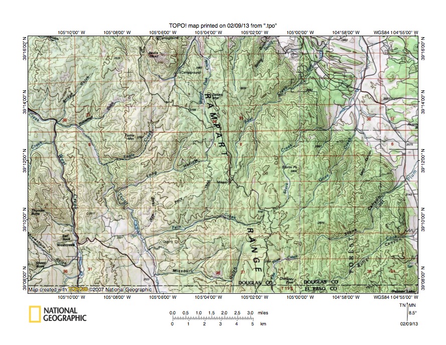
Figure 7: Bear Creek-Fern Creek drainage divide area. United States Geological Survey map digitally presented using National Geographic Society TOPO software.
Figure 7 illustrates the Bear Creek-Fern Creek drainage divide area south and east of figure 5 and there is an overlap area with figure 5. The map contour interval for figure 7 is 50 meters. Trout Creek flows in a north-northwest direction from the south edge of figure 7 (west of center) and then turns in a northwest direction to join north oriented West Creek to form northwest oriented Horse Creek, which flows to the west edge of figure 7 (north half). West of figure 7 Horse Creek joins the north-northeast oriented South Platte River. Barbed tributaries flow to north oriented Trout and Horse Creeks in southwest directions and include Bridge Gulch, Polhemus Gulch, Eagle Creek, Long Hollow, and maybe Fern Creek. Barbed tributaries also flow in southeast directions to north oriented West Creek near the southwest corner of figure 7. The barbed tributaries provide evidence the flow direction in the Trout Creek and West Creek valleys was at one time in a south direction and has since been reversed. If so the Trout Creek and West Creek valleys were initiated by diverging south oriented flood flow channels and barbed tributary valleys were probably initiated by converging flood flow channels suggesting the emerging Rampart Range was crossed by an anastomosing complex of south oriented channels. Bear Creek originates near the center of figure 7 and flows in a north, northeast, and north direction to the north edge of figure 7 (east half). North of figure 7 Bear Creek joins Stark Creek to form north oriented West Plum Creek, which joins East Plum Creek to form north-northwest oriented Plum Creek, which flows to the north-northeast oriented South Platte River. Stark Creek originates south and east of the Bear Creek headwaters and east of the Fern Creek headwaters and flows in an east, north, northeast, north-northeast, and north direction to the north edge of figure 7 (near northeast corner). North of figure 7 Stark Creek joins Bear Creek to form north oriented West Plum Creek. East Plum Creek flows in a north, east-northeast, and northeast direction from the south edge of figure 7 (slightly east of center) to the east center edge of figure 7. East of figure 7 East Plum Creek flows in a north and northwest direction to join north oriented West Plum Creek and to form north-northwest oriented Plum Creek. A close look at the crest of the Rampart Range reveals through valleys linking valleys on either side of the present day drainage divide. For example a north-to-south oriented through valley links the north oriented Stark Creek headwaters valley with the west-southwest oriented Fern Creek valley and is defined by at least two 50-meter contour lines. The through valley was probably eroded by south oriented flood moving from the present day north oriented Stark Creek headwaters alignment to the south-southwest headwaters valley of Missouri Gulch (near south center edge of figure 7). Even more intriguing elevations along Rampart Range crest in this region are in places lower than 2750 meters. North of figure 7 at Devils Head elevations rose to more than 2950 meters and south of figure 7 elevations rise to more than 2850 meters. This lower region along the Rampart Range crest was probably eroded by flood flow moving across the present day Rampart Range crest.
Detailed map of Stark Creek-Fern Creek drainage divide area
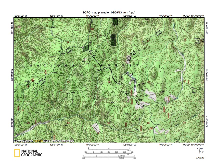
Figure 8: Detailed map of Stark Creek-Fern Creek drainage divide area. United States Geological Survey map digitally presented using National Geographic Society TOPO software.
Figure 8 provides a detailed topographic map of the Stark Creek-Fern Creek drainage divide seen in less detail figure 7. The map contour interval for figure 8 is 40 feet. Fern Creek originates north of the south center edge of figure 8 and flows in a west-northwest and west-southwest direction to the southwest corner of figure 8. West and south of figure 8 Fern Creek flows in a west-southwest direction to join north and northwest oriented Trout Creek, which flows to northwest oriented Horse Creek, which flows to the north-northeast oriented South Platte River. The north oriented stream originating in the northeast quadrant of section 18 (north of the Fern Creek headwaters) is a tributary to north-northeast oriented Bear Creek, which flows to the north edge of figure 8 (east of center). North of figure 8 Bear Creek flows in a north and northeast direction to join Stark Creek and to form north oriented West Plum Creek, which joins East Plum Creek to form north-northwest oriented Plum Creek, which flows to the north-northeast oriented South Platte River. Through valleys link the north oriented Bear Creek tributary valley with the west and west-southwest oriented Fern Creek valley. The deepest through valley has a floor elevation of between 8800 and 8840 feet. Elevations to the east rise to more than 9280 feet at the Microwave Site and elevations to the northwest (along the road near the north edge of figure 8) also rise to more than 9280 feet. These elevations suggest the deepest through valley is at least 440 feet deep. The through valleys are water-eroded features and were eroded by south oriented flood flow from the present day north oriented Bear Creek tributary alignment, which was flowing to a south oriented flood flow channel on the present day south-southwest oriented Missouri Gulch headwaters alignment (south of figure 8). Headward erosion of the west oriented Fern Creek valley captured the south oriented flood flow and subsequently a reversal of flood flow on the Plum Creek alignment reversed flood flow on the Bear Creek tributary alignment. Stark Creek originates near the south center margin of section 17 and flows in a southeast direction to the northeast corner of section 20 where it turns to flow in a north direction across section 16 and then to the north edge of figure 8. North of figure 8 Stark Creek flows in a northeast, north-northeast, and northwest direction to join Bear Creek and to form north oriented West Plum Creek. The southeast oriented Stark Creek headwaters are linked by a north-to-south oriented through valley in section 17 with a north and northeast oriented Stark Creek tributary. The through valley is defined by at least four 40-foot contour lines on each side and was eroded by south oriented flood flow, which had been flowing to the south-southwest oriented Fern Creek headwaters valley seen in section 20 prior to the reversal of flood flow on the Stark Creek alignment. Numerous similar through valleys can be seen in figure 8 and provide evidence of complex flood flow movements as floodwaters were captured by headward erosion of deeper and deeper valleys and as south oriented flood flow channels were beheaded and reversed to create the north oriented drainage routes seen today.
Fern Creek-East Plum Creek drainage divide area

Figure 9: Fern Creek-East Plum Creek drainage divide area. United States Geological Survey map digitally presented using National Geographic Society TOPO software.
Figure 9 illustrates the Fern Creek-East Plum Creek drainage divide area south and east of figure 7 and there is an overlap area with figure 7. The map contour interval for figure 9 is 50 meters. The eastern flank of the Rampart Range extends in a north to-south direction across the east half of figure 9. The Colorado Piedmont is located east of the Rampart Range. Palmer Lake is a town located along the eastern edge of the Rampart Range (in east center area of figure 9). Carpenter Creek originates just north of Palmer Lake and flows in a northeast and north direction to the northeast corner of figure 9. North of figure 9 Carpenter Creek joins East Plum Creek, which flows in a north and northwest direction to join West Plum Creek to form north-northwest oriented Plum Creek, which flows to the north-northeast oriented South Platte River with water eventually reaching the Platte, Missouri, and Mississippi Rivers. East-northeast and northeast oriented streams flowing from the Rampart Range to Palmer Lake are headwaters of southeast and south-southeast oriented Monument Creek, which flows to the southeast corner of figure 9. South and east of figure 9 Monument Creek joins south oriented Fountain Creek, which flows to the east oriented Arkansas River, which eventually flows directly to the Mississippi River. A through valley at Palmer Lake links the northeast oriented Carpenter Creek valley with the southeast oriented Monument Creek valley segment and also with the northeast oriented Monument Creek headwaters valleys in the Rampart Range. East Plum Creek originates in the northwest corner of El Paso County and flows in a north-northeast, north, east-northeast, and northeast direction to and through Stone Canyon and then to the north edge of figure 9 (east half). North of figure 9 East Plum Creek flows in a northeast, north, and northwest direction to join West Plum Creek and to form north-northwest oriented Plum Creek. Trout Creek flows in a north and north-northwest direction from the south edge of figure 9 (west half) to near the northwest corner of figure 9. North and west of figure 9 Trout Creek joins north oriented West Creek to form northwest oriented Horse Creek, which flows to the north-northeast oriented South Platte River. Trout Creek tributaries from the east (from north to south) include Fern Creek, Missouri Gulch, White Spruce Gulch, Hotel Gulch, and Johns Gulch. South of figure 9 Trout Creek headwaters are linked by north-to-south oriented through valleys with valleys of south oriented tributaries (west of the Rampart Range) to the Arkansas River. The Rampart Range apparently emerged between two major south oriented flood flow routes, which had been captured by headward erosion of the east oriented Arkansas River valley (south of figure 9). South oriented flood flow on the Colorado Piedmont (east of the Rampart Range) was subsequently beheaded and reversed while south oriented flood flow continued to move across what at that time was the emerging Rampart Range along the Trout Creek alignment and further to the west along the South Platte River alignment, although those south oriented flood flow routes were also beheaded and reversed to create the north oriented drainage routes seen today.
Detailed map of Fern Creek-East Plum Creek drainage divide area

Figure 10: Detailed map of Fern Creek-East Plum Creek drainage divide area. United States Geological Survey map digitally presented using National Geographic Society TOPO software.
Figure 10 provides a detailed topographic map of the Fern Creek-East Plum Creek drainage divide area seen in less detail in figure 9. Figure 10 is located directly south of figure 8 and includes overlap areas with figure 8. The map contour interval for figure 10 is 40 feet. Fern Creek originates in section 20 (in northeast quadrant of figure 10) and flows in a west-northwest and west-southwest direction to the west edge of figure 10. West of figure 10 Fern Creek flows to north and northwest oriented Trout Creek, which flows to northwest oriented Horse Creek, which then flows to the north-northeast oriented South Platte River. Missouri Gulch originates in section 30 (near center of figure 10) and drains in a south-southwest direction almost to the south edge of figure 10 and then turns to drain in a west direction to the west edge of figure 10 (near southwest corner). West of figure 10 Missouri Gulch drains to north and northwest oriented Trout Creek. A southwest oriented tributary drains across section 25 to join Missouri Gulch near the southwest corner of figure 10. Through valleys link the Fern Creek valley with the Missouri Gulch valley and with the southwest oriented Missouri Gulch tributary valley. For example in the northwest corner of section 30 a north-to-south oriented through valley links the Fern Creek valley with both the Missouri Gulch headwaters valley and the headwaters valley of the southwest oriented Missouri Gulch tributary. The through valley is defined by at least two 40-foot contour lines. Further to the east in the north center area of section 30 a higher elevation through valley also crosses the drainage divide and is also defined by at least two contour lines. These and other similar through valleys provide evidence of the multiple south oriented flood flow routes prior to headward erosion of the deeper west oriented Fern Creek valley. East Plum Creek flows in a north and east direction from the south edge of figure 10 (east half) to the east edge of figure 10 (south half). East of figure 10 East Plum Creek flows in a northeast, north, and northwest direction to join north oriented West Plum Creek and to form north-northwest oriented Plum Creek, which flows to the north-northeast oriented South Platte River. The northeast oriented stream flowing across section 21 to the northeast corner of figure 10 is Gove Creek, which north and east of figure 10 flows in a north-northeast and north direction to join West Plum Creek. Shallow north-to-south oriented through valleys cross the Gove Creek-East Plum Creek drainage divide and provide evidence of more south oriented flood flow routes captured first by headward erosion of the East Plum Creek valley and subsequently by headward erosion of the northeast oriented Gove Creek valley. The north oriented East Plum Creek drainage route was created by a reversal of flood flow on the north end of a beheaded flood flow route. North and south oriented tributaries to the east oriented East Plum Creek segment provide additional evidence the East Plum Creek valley eroded headward across multiple south oriented flood flow channels.
Additional information and sources of maps studied
This essay has provided only a sample of the detailed topographic map evidence supporting the flood erosion interpretation. Many additional illustrations could be provided. Readers are encouraged to look at mosaics of detailed topographic maps to see the abundance of available data. Maps used in this study were created and published by the United States Geologic Survey and can be obtained directly from the United States Geological Survey and/or from dealers offering United States Geological Survey maps. Hard copy maps can also be observed at United States Geological Survey map depositories, which are located throughout the United States and elsewhere. Illustrations used here were created using National Geographic Society TOPO software and digital map data. TOPO software and map data can be obtained from the National Geographic Society and/or dealers offering National Geographic Society digital map data.

Leave a comment