
South Fork Flathead River-Blackfoot River drainage divide area landform origins, western Montana, USA
Abstract:
Topographic map evidence is used to explore the western Montana drainage divide between north-oriented South Fork Flathead River tributaries and south oriented Blackfoot River tributaries. The South Fork Flathead River flows in a northwest direction between the Lewis and Clark Range and the Swan Range while to the south the Blackfoot River flows in a west direction between the Swan Range and the Garnet Range. Mountain passes or through valleys, with varying floor elevations, link north oriented South Fork Flathead River tributary valleys with south oriented Blackfoot River tributary valleys. The deepest of the passes or through valleys is the Danaher Creek-Dry Fork Blackfoot River through valley, which has a floor elevation of between 1600 meters and 1650 meters and which is approximately 450 meters deeper than adjacent mountain ridges and almost 1000 meters deeper than adjacent mountain range peaks. Further to the west of this deep though valley mountain passes with much higher floor elevations in the 2100 meters to 2200 meter range link north oriented South Fork Flathead River tributaries with south oriented Blackfoot River tributaries. Anastomosing channels of south oriented floodwaters eroded these mountain pass valleys at a time when the Swan Range and the Lewis and Clark Range were emerging. Floodwaters were derived from the western margin of a thick North American and probably flowed in south and southeast direction in what are today the Rocky Mountain Trench and adjacent Canadian Rocky Mountain valleys to reach western Montana. Crustal warping and erosion of a much deeper valley enabled the Danaher Creek-Dry Fork Blackfoot River route to behead and reverse flow routes that crossed what are today the higher elevation mountain passes. Subsequently headward erosion of the deep south oriented Flathead River valley around the Swan Range north end beheaded and reversed flow north of the Danaher Creek-Dry Fork Blackfoot River drainage divide to create the South Fork Flathead River drainage basin.
Preface
The following interpretation of detailed topographic map evidence is a supplement to a series of essays describing similar evidence for all major drainage divides contained within the Missouri River drainage basin and for all major drainage divides with adjacent drainage basins. The research project is interpreting evidence in the context of a previously unexplored deep glacial erosion paradigm, which is fundamentally different from most commonly accepted North American glacial history interpretations. Project essays are listed on the website sidebar category list under their appropriate Missouri River tributary drainage basin, Missouri River segment drainage basin (by state), and/or state in which the Missouri River drainage basin is located.
Introduction
The purpose of this essay is to use topographic map interpretation methods to explore the South Fork Flathead River-Blackfoot River drainage divide area landform origins, which located west of the east-west continental divide and west of the Missouri River drainage basin. Map interpretation methods can be used to unravel many geomorphic events leading up to formation of present-day drainage routes and development of other landform features. While each detailed topographic map feature provides detailed evidence to be explained, the solution must be consistent with explanations for adjacent area map evidence as well as solutions to big picture map evidence puzzles. I invite readers to improve upon my solutions and/or to propose alternate solutions that better explain evidence and are also consistent with adjacent map area and big-picture evidence. Readers may do so either by making comments here or by writing and publishing their own essays and then by leaving a link to those essays in a comment here.
This essay is also exploring a new geomorphology paradigm in which erosional landforms are interpreted as evidence left by immense glacial melt water floods. Implied in that interpretation is the immense floods were derived from a thick North American ice sheet that created a deep “hole” in the North American continent and also melted fast. The previously unexplored paradigm being tested in this and similar essays (found on this website) is a thick North American ice sheet, comparable in thickness to the Antarctic ice sheet, occupied the North American region usually recognized to have been glaciated, and through its weight and erosive actions created a deep North American “hole”. The southwestern rim of that deep “hole” is today preserved in the high Rocky Mountains. The ice sheet through its weight and deep erosion (and perhaps deposition along major south-oriented melt water flow routes) caused significant crustal warping and tectonic change, through its action of melting fast produced immense floods that flowed across the continent, and through its action of melting fast systematically opened up space in the ice sheet created “hole” so headward erosion of newly developed north-oriented drainage systems captured immense south-oriented melt water floods and diverted immense melt water floods north into space the ice sheet had once occupied.
If this previously unexplored paradigm is correct the geographic region explored by this essay should contain evidence of immense floods that were captured by headward erosion of new valley systems so as to cause the floods to flow in a different direction. Ability of this previously unexplored paradigm to explain South Fork Flathead River-Blackfoot River drainage divide area landform evidence along the east-west continental divide will be regarded as evidence supporting the “thick ice sheet that melted fast” paradigm.
South Fork Flathead River-Blackfoot River drainage divide area location map

Figure 1: South Fork Flathead River-Blackfoot River drainage divide area location map (select and click on maps to enlarge). National Geographic Society map digitally presented using National Geographic Society TOPO software.
Figure 1 provides a location map for the South Fork Flathead River-Blackfoot River drainage divide area in northwestern Montana. The Missouri River flows in a north and northeast direction across the southeast corner of figure 1 and water eventually reaches the Gulf of Mexico. Other east oriented rivers and streams flowing to the east edge of figure 1 are Missouri River tributaries and originate along or near the east-west continental divide. Clark Fork is the unlabeled west-northwest oriented flowing parallel to Interstate Highway 90 across the southwest corner of figure 1 with water eventually reaching the Pacific Ocean. The Blackfoot River originates along the west side of the Lewis and Clark Range (near south center of figure 1) and flows in a west direction to join Clark Fork near Missoula. Note south oriented Blackfoot River headwaters and tributaries. North of the Blackfoot River headwaters and between the Lewis and Clark Range and the Swan Range is the north-northwest oriented South Fork Flathead River, which flows to Hungry Horse Reservoir and then to join the northwest and southwest oriented Middle Fork Flathead River and south oriented North Fork Flathead River to form the south oriented Flathead River, which flows to Flathead Lake. South of Flathead Lake the Flathead River flows in a south and west direction to join Clark Fork west of figure 1. Note how the Middle Fork Flathead River, South Fork Flathead River, and Swan River all flow in north directions to join the south oriented Flathead River, which in turn joins northwest oriented Clark Fork, which west of figure 1 reaches south and west oriented Columbia River.
The Flathead River, like many other Montana rivers, has barbed tributaries, which flow in one direction to join a river flowing in the opposite direction. Barbed tributaries and river U-turns are important evidence, which can be used to help reconstruct previous drainage routes. Topographic map evidence illustrated later in this essay can be used to test drainage route reconstructions. To understand Montana drainage history it is necessary to visualize the North American continent at a time when an Antarctic size ice sheet covered much of the northern half of the continent. The weight of the ice sheet and glacial erosion created a deep “hole” in which the ice sheet was located and the figure 1 region was located along the southwest rim of that deep “hole”. Mountain ranges seen in figure 1 were uplifted as tectonic action triggered by the ice sheet weight raised the deep “hole” west and southwest rims and other regions further to the south and west. Immense floods of melt water poured off the ice sheet both to the south and to the west as the mountain ranges emerged. The emerging Canadian Rock Mountains (north and west of figure 1) funneled at least some of the west flowing melt water in a south direction to cross western Montana. At least some of this south flowing melt water probably eroded the Rocky Mountain Trench (a deep valley in the Canadian Rocky Mountain region, which is now drained by segments of several different rivers) with the melt water continuing to cross what is now the Flathead River drainage basin. Immense melt water floods probably entered the Flathead River drainage basin throughout the ice sheet’s entire history, up until Kootenai River valley headward erosion beheaded and captured the melt water flood flow.
What are today north oriented Flathead River tributaries originated as diverging south oriented flood flow channels. Of interest in this essay is the South Fork Flathead River valley between the Lewis and Clark Range and the Swan Range. Floodwaters flowed in a south direction between the emerging Lewis and Clark Range and Swan Range. Prior to headward erosion of the west oriented Blackfoot River valley floodwaters continued south to what is today the north oriented Clark Fork headwaters valley and then south along the present day south oriented Big Hole River valley segment to the present day north oriented Beaverhead River valley, and then further south into Idaho and Nevada. As the ice sheet related tectonic action raised mountain ranges and deep valleys eroded headward from the Pacific and Atlantic Oceans to capture the gigantic flood flows. The south oriented flood flow channels were systematically dismembered and in some cases the direction of flood flow was reversed. Of interest to this essay a southeast and south oriented flood flow route was systematically reversed to create the present day northwest oriented Clark Fork drainage route. The west oriented Blackfoot River valley then eroded headward from this newly reversed flood flow route to capture south oriented flood flow moving between the Mission Range and the Swan Range and between the Swan Range and the Lewis and Clark Range. Next headward erosion of a deep south oriented alley along the present day Flathead River alignment beheaded and reversed south oriented flood flow between the Mission Range and the Swan Range to create the north oriented Swan River. Continued headward erosion of the deep south-oriented Flathead River valley next beheaded and reversed south oriented flood flow between the Swan Range and the Lewis and Clark Range to create the north oriented South Fork Flathead River. Reversal of flow on the Swan River and South Fork Flathead River alignments was probably greatly aided by ice sheet related tectonic activity. Topographic maps illustrate in this essay evidence that south oriented floodwaters once flowed at what are today high elevations from the present day north oriented South Fork Flathead River drainage basin to south oriented Blackfoot River tributaries.
Detailed location map for South Fork Flathead River-Blackfoot River drainage divide area
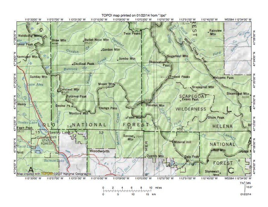
Figure 2: Detailed location map South Fork Flathead River-Blackfoot River drainage divide area. United States Geological Survey map digitally presented using National Geographic Society TOPO software.
Figure 2 provides a detailed location map for the South Fork Flathead River-Blackfoot River drainage divide area west of the east-west continental divide. Green colored areas are National Forest lands and are generally located in mountainous regions. The Blackfoot River is located south of figure 2 and flows in west direction. South oriented streams flowing to the south edge of figure 2 are Blackfoot River tributaries. Landers Fork of the Blackfoot River flows in a southeast direction to the east edge of figure 2 (near southeast corner). Further west the Dry Fork Blackfoot River flows in a south-southeast direction to join the south-southwest oriented North Fork Blackfoot River, which flows to the south edge of figure 2 (slightly east of center). Monture Creek originates near the Moser Mountains (near center of figure 2) and flows in a south direction to the south edge of figure 2 (slightly west of center). Further west the Clearwater River flows in a south-southeast direction near the west edge of figure 2. The Danaher Creek drainage basin is nicely outlined in the north half of figure 2 by Ranger District boundaries and drains in a north direction to the north-northwest oriented South Fork Flathead River. Note how Danaher Creek originates near headwaters of the Dry Fork Blackfoot River. Topographic maps, shown below, document a deep through valley linking the two opposing drainage routes. Similar through valleys link south oriented Monture Creek headwaters and tributaries with north oriented (and unlabeled in figure 2) Youngs Creek tributaries, with Youngs Creek being a labeled Danaher Creek tributary. These multiple north to south oriented through valleys illustrated in the topographic maps below are evidence of multiple south oriented flood flow channels, which existed prior to the reversal of flow that created the north oriented South Fork Flathead River drainage basin. The flood flow reversal was triggered by headward erosion of the deep south oriented Flathead River valley west and north of figure 2, but was also probably aided by ice related crustal warping that raised the present day South Fork Flathead River-Blackfoot River drainage divide area.
Danaher Creek-Dry Fork Blackfoot River drainage divide area

Figure 3: Danaher Creek-Dry Fork Blackfoot River drainage divide area. United States Geological Survey map digitally presented using National Geographic Society TOPO software.
Figure 3 provides a topographic map of Danaher Creek-Dry Fork Blackfoot River drainage divide area. The map contour interval for figure 3 is 50 meters. Danaher Creek (labeled “Creek” in figure 4) originates near the center of figure 3 and flows in a north direction through Danaher Meadows to the north center edge of figure 3. North of figure 3 Danaher Creek flows to the north-northwest oriented South Fork Flathead River, which flows to the south oriented Flathead River. The Dry Fork Blackfoot River originates south of the Observation Point (west of the northeast corner of figure 3) and flows in a southwest direction to near the center of figure 3 (south of Concord Mountain) where it turns to flow in a south-southeast direction to the south edge of figure 3 (east half). South of figure 3 the Dry Fork Blackfoot River joins the Blackfoot River, which flows in a west direction to join northwest oriented Clark Fork. Note how the Dry Fork Blackfoot River elbow of capture (on south side of Concord Mountain) is linked by a deep through valley with the north oriented Danaher Creek valley. The through valley floor elevation is between 1600 and 1650 meters. Concord Mountain on the east side rises to 2115 meters while Danaher Mountain on the west side rises to 2457 meters suggesting the through valley is at least 450 meters deep. The through valley is a water eroded feature and was eroded by south oriented flood flow moving from the present day north oriented South Fork Flathead River drainage basin to the Blackfoot River drainage basin. The Danaher Creek-Dry Fork Flathead River through valley is the deepest of several through valleys linking the two opposing drainage basins and was the final route used by floodwaters before crustal warping and Flathead River valley headward erosion caused a reversal of flow in the South Fork Flathead River drainage basin. Elevations of other through valleys suggest floodwaters flowed across the region prior to the regional uplift and erosion that created the present day mountains. For example Limestone Pass in the east center area of figure 3 has a floor elevation of between 2700 and 2750 meters and is at least 130 meters lower than adjacent mountain ridges and was probably eroded by south flowing flood flow. If so, south flowing floodwaters eroded an 1100 meter deep valley along the Danaher Creek-Dry Fork Blackfoot River route after flow across Limestone Pass ended, which probably suggests 1100 meters of regional uplift between the time flow across Limestone Pass ended and the time south oriented flow in the Danaher Creek-Dry Fork Blackfoot River through valley ended. Figures 5-10 illustrate other flood eroded through valleys.
Detailed map of Danaher Creek-Dry Fork Blackfoot River drainage divide area
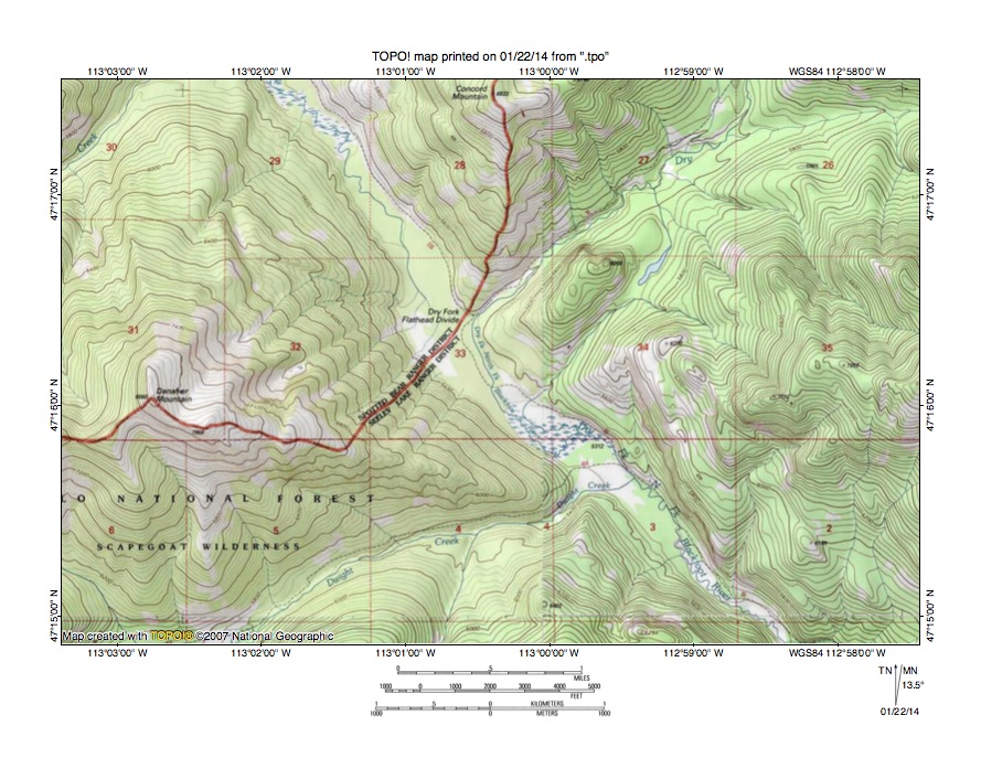
Figure 4: Detailed map of Danaher Creek-Dry Fork Blackfoot River drainage divide area. United States Geological Survey map digitally presented using National Geographic Society TOPO software.
Figure 4 provides a detailed topographic map of the Danaher Creek-Dry Fork Blackfoot River drainage divide area seen in less detail in figure 3. The map contour interval for figure 4 is 40 feet. The Dry Fork Flathead Divide in the Danaher Creek-Dry Fork Blackfoot River through valley is labeled and is located near the center of figure 4. Danaher Creek flows in a northwest direction from the labeled divide while the Dry Fork Blackfoot River flows in a southwest direction from the north edge of figure 4 (east half) to near the labeled divide and then turns to flow in a southeast direction to the south edge of figure 4 (east half). The Danaher Creek-Dry Fork Blackfoot River through valley floor elevation at the labeled divide is between 5320 and 5360 feet. Concord Mountain near the north center edge of figure 4 reaches an elevation of 6933 feet while Danaher Mountain in the west half of figure 4 reaches an elevation of 8060 feet. These elevations suggest the Danaher Creek-Dry Fork Blackfoot River through valley is approximately 1600 feet deep. The through valley is a water eroded feature and was eroded by south flowing melt water floods prior to the reversal of flow that created the northwest oriented South Fork Flathead River (including Danaher Creek) drainage basin. The reversal of flood flow was probably greatly aided by ice sheet related crustal warping that was raising the present day drainage divide area as floodwaters were eroding a deeper and deeper valley. Headward erosion of the still deeper south oriented Flathead River valley (west of figure 4) eventually beheaded and reversed the southeast oriented flood flow to create the northwest oriented South Fork Flathead River drainage basin.
Jenny Creek-Dunham Creek drainage divide area
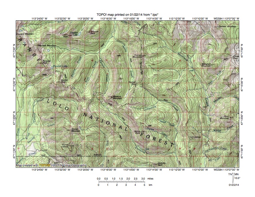
Figure 5: Jenny Creek-Dunham Creek drainage divide area. United States Geological Survey map digitally presented using National Geographic Society TOPO software.
Figure 5 illustrates the Jenny Creek-Dunham Creek drainage divide area west and slightly south of figure 3 and there is an overlap area with figure 3. The map contour interval for figure 5 is 50 meters. The mountains in the northwest corner of figure 5 (labeled “Range”) are at the Swan Range south end. South oriented drainage routes west and south of the Swan Range flow to the Clearwater River, which in turn flows to the west oriented Blackfoot River. Monture Creek is the southeast and south oriented stream originating in the northeast quadrant of figure 5 and flowing near the east edge of figure 5 to the south edge of figure 5 (near southeast corner). South of figure 5 Monture Creek flows to the west oriented Blackfoot River. The unlabeled east and north oriented stream originating east of Marshall Mountain (near northeast corner of figure 5) and flowing to the north center edge of figure 5 is Youngs Creek, which north of figure 5 joins Danaher Creek to form the northwest oriented South Fork Flathead River. North oriented Youngs Creek tributaries seen in figure 5 from east to west are Jenny Creek, Spruce Creek, Ross Creek, and Devine Creek. South of the Spruce Creek headwaters are headwaters of southeast, east and south oriented Dunhan Creek, which flows to the south edge of figure 5 (east half). South of figure 5 Dunham Creek joins Monture Creek, which flows to the west oriented Blackfoot River. South and slightly east of the Jenny Creek headwaters are headwaters of east, southeast, and south oriented Lodgepole Creek, which is a Dunham Creek tributary. Youngs Pass (near center of figure 5) links the north oriented Jenny Creek valley with a southeast oriented Lodgepole Creek tributary. The Youngs Pass floor elevation is between 2100 and 2150 meters. The mountain immediately to the south rises to more than 2350 meters and Youngs Mountain to the north rises to 2500 meters suggesting Youngs Pass is at least 200 meters deep. Youngs Pass is a water-eroded feature and was eroded by south oriented flood flow. Flow in the Youngs Creek drainage basin was beheaded and reversed by headward erosion of a deeper valley along the Danaher Creek-Dry Fork Blackfoot River through valley route seen in figures 3 and 4. Other deep north to south oriented through valleys can be seen in figure 5 at the south ends of the north oriented Jenny Creek and Spruce Creek valleys and provide evidence multiple flood flow channels as might be found in a flood formed south oriented anastomosing channel complex and are better seen in figure 6 below.
Detailed map of Jenny Creek-Dunham Creek drainage divide area
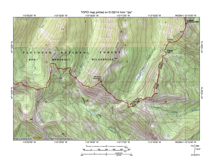
Figure 6: Detailed topographic map of Jenny Creek-Dunham Creek drainage divide area. United States Geological Survey map digitally presented using National Geographic Society TOPO software.
Figure 6 provides a detailed topographic map of the Jenny Creek-Dunham Creek drainage divide area seen in less detail in figure 5. The map contour interval for figure 6 is 40 feet. The well-marked Ranger District boundary is located along the Youngs Creek-Dunham Creek drainage divide with north flowing streams flowing to Youngs Creek and the South Fork Flathead River and Dunham Creek flowing in a southeast direction to the south center edge of figure 5 and south of figure 6 to south oriented Monture Creek, which in turn flows to the west oriented Blackfoot River. Youngs Pass is located in the northeast quadrant of figure 6 and links the north oriented Jenny Creek valley with headwaters of a southeast oriented stream flowing to Lodgepole Creek, which in turn flows to Dunham Creek. The Youngs Pass floor elevation is between 6880 feet and 6920 feet and is approximately1100 feet lower than elevations of the ridge to the south and 1200 feet lower than the ridge near the north edge of figure 6. Following the ridge to the south end of the Jenny Creek valley leads to another deep pass linking the Jenny Creek valley with the Dunham Creek valley. This unnamed pass has a floor elevation of between 7040 and 7080 feet. Continuing along the drainage divide to the west side of Monture Mountain an even deeper pass links the north oriented Spruce Creek valley with Dunham Creek headwaters. This third pass has a floor elevation of between 6720 and 6760 feet and is deeper than Youngs Pass. Still further along the drainage a much shallower pass links the north oriented Ross Creek alley with the Dunham Creek valley. This fourth pass has a floor elevation of between 7400 and 7440 feet. These four passes provide evidence of what at one time were four anastomosing flood flow channels. Flood flow across the fourth pass ended and was reversed while flood flow continued to move through the other three passes. The final south oriented flood flow in this region used the Spruce Creek-Dunham Pass route before being diverted to the much deeper Danaher Creek-Dry Fork Blackfoot River through valley route seen in figures 3 and 4.
Youngs Creek-Monture Creek drainage divide area
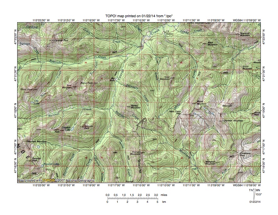
Figure 7: Youngs Creek-Monture Creek drainage divide area. United States Geological Survey map digitally presented using National Geographic Society TOPO software.
Figure 7 illustrates the Youngs Creek-Monture Creek drainage divide area north and slightly east of figure 5 and includes an overlap area with figure 5. The map contour interval for figure 7 is 50 meters. The Swan Range crest can be seen extending across the southwest corner of figure 7. Youngs Creek originates in the southwest quadrant of figure 7 and flows in an east, north, and northeast direction to the north edge of figure 7 (east of center). Delaware Creek is a northwest oriented Youngs Creek tributary located near the center of figure 7. North and east of figure 7 Youngs Creek joins Danaher Creek to form northwest oriented South Fork Flathead River. Otter Creek is a north oriented Youngs Creek tributary east of Delaware Creek and Hahn Creek is a northeast and northwest oriented Youngs Creek tributary located east of Otter Creek. Monture Creek originates just south of the Delaware, Otter, and Hahn Creek headwaters and flows in a southeast direction to the south edge of figure 7 (east half). South of figure 7 Monture Creek flows to the west oriented Blackfoot River. A deep north to south oriented through valley links the north and northwest oriented Delaware Creek valley with the southeast oriented Monture Creek valley. The through valley was eroded by southeast and south oriented flood flow prior to the reversal of flow in the Youngs Creek drainage basin. The through valley floor elevation is between 2150 and 2200 meters. Railey Mountain immediately to the west rises to 2493 meters and Moser Mountain to the east rises to 2604 meters suggesting the through valley is at least 300 meters deep. An even deeper through valley labeled as Hahn Creek Pass links the north oriented Hahn Creek valley with the south oriented Monture Creek valley and has a floor elevation of between 2050 and 2100 meters and is at least 400 meters deep. Note how the Hahn Creek Pass through valley is aligned with a higher level through valley linking the north oriented Otter Creek valley with the northeast oriented Hahn Creek headwaters valley. These through valleys provide evidence of what were diverging and converging south oriented flood flow channels being eroded into the emerging mountain mass prior to reversal of flow in the Youngs Creek drainage basin.
Detailed map of Delaware Creek-Monture Creek drainage divide area
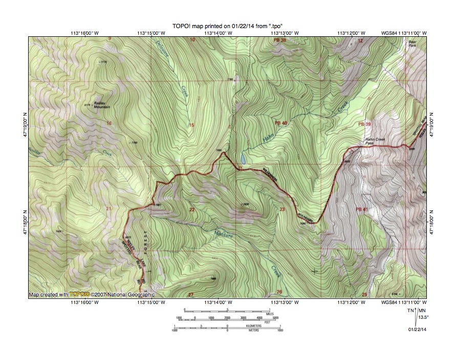
Figure 8: Detailed map of Delaware Creek-Monture Creek drainage divide area. United States Geological Survey map digitally presented using National Geographic Society TOPO software.
Figure 8 provides a detailed topographic map of the Delaware Creek-Monture Creek drainage divide area seen in less detail in figure 7. The map contour interval for figure 8 is 40 feet. The well-marked ranger district boundary is located along the Youngs Creek-Monture Creek drainage divide. Delaware Creek originates in section 15 and flows in a north-northwest direction to the north edge of figure 8 (west of center). Hahn Creek originates at a small lake near the center of figure 8 and flows in a northeast direction to near the northeast corner of figure 8. North of figure 8 Delaware Creek and Hahn Creek join northeast oriented Youngs Creek, which subsequently joins Danaher Creek to form the northwest oriented South Fork Flathead River. Monture Creek originates in section 22 and flows in a southeast direction to the south edge of figure 8 (east of center). South of figure 8 Monture Creek flows to the west oriented Blackfoot River. A deep and narrow through valley straddling the section 15-section 22 border links the north oriented Delaware Creek valley with the southeast oriented Monture Creek valley. The through valley has a floor elevation of between 7120 and 7160 feet and is more than 600 feet lower than adjacent high points in section 22. If high points further along the drainage divide are used the through valley could be as much as 1300 feet deep. The through valley is a water eroded feature and was eroded by south oriented flood flow prior to the reversal of flow in the Youngs Creek drainage basin. Hahn Creek Pass is located in the east center edge are of figure 8 and is a much deeper through valley with a floor elevation of between 6600 and 6640 feet. Depending on which ridge elevations are used Hahn Creek Pass could be anywhere from 1000 to 2000 feet deep. Hahn Creek pass was eroded by south oriented flood flow prior to reversal of flow in the Youngs Creek drainage basin. Crustal warping that occurred as floodwaters crossed the region contributed the reversal of flow, as did erosion of a much deeper flood flow channel on the Danaher Creek-Dry Fork Blackfoot River alignment (seen in figures 3 and 4).
Babcock Creek-Morell Creek drainage divide area

Figure 9: Babcock Creek-Morell Creek drainage divide area. United States Geological Survey map digitally presented using National Geographic Society TOPO software.
Figure 9 illustrates the Babcock Creek-Morell Creek drainage divide area west of figure 7 and there is an overlap area with figure 7. The map contour interval for figure 9 is 50 meters. The Swan Range crest is labeled and extends in a north-northwest direction from the south center edge of figure 9. Drainage west of the Swan Range crest flows to the south oriented Clearwater River (seen in the southwest corner of figure 9), which in turn flows to the west oriented Blackfoot River. Morell Creek originates on the east side of the Swan Range crest and flows in a southeast direction before turning in a southwest direction to flow across the Swan Range and then turning to flow in a south direction to the south edge of figure 9 (west of center). South of figure 9 Morell Creek joins the Clearwater River. The Morell Creek water gap cut across the Swan Range is between 500 and 750 meters deep depending on where it is measured. North of the Morell Creek headwaters are the Babcock Creek headwaters with Babcock Creek flowing in an east direction to join Youngs Creek near the northeast corner of figure 9. A north to south oriented through valley in section 6 (just east of north oriented Reef Creek) links the Babcock Creek headwaters area with the Morell Creek headwaters area and has a floor elevation of between 2150 and 2200 meters. Mountains on either side rise to approximately 2500 meters suggesting the through valley is approximately 300 meters deep. The through valley was eroded by south oriented flood flow prior to headward erosion of the deeper east oriented Babcock Creek valley. The south oriented flood flow was responsible for erosion of the Morell Creek water gap into what was at that time was an emerging Swan Range. Continued crustal warping plus reversal of flow in the Youngs Creek drainage basin enabled headward erosion of the deeper east oriented Babcock Creek valley to capture south oriented flood flow moving to the Morell Creek valley.
Detailed map of Babcock Creek-Morell Creek drainage divide area
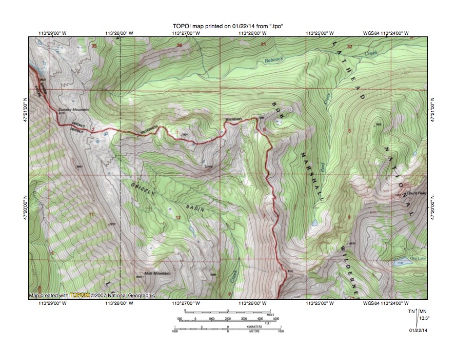
Figure 10: Detailed map of Babcock Creek-Morell Creek drainage divide area. United States Geological Survey map digitally presented using National Geographic Society TOPO software.
Figure 10 provides a detailed topographic map of the Babcock Creek-Morell Creek drainage divide area seen in less detail in figure 9. The map contour interval for figure 10 is 40 feet. The well-marked Ranger District boundary is located along the South Fork Flathead River-Blackfoot River drainage divide. The Swan Range crest extends in a south-southeast direction from the northwest corner of figure 10. Babcock Creek originates near the northwest corner of figure 10 and flows in an east direction near the north edge of figure 10. East and north of figure 10 Babcock Creek joins Youngs Creek, which then flows to join Danaher Creek and to form the northwest oriented South Fork Flathead River. Reef Creek is the north oriented Babcock Creek tributary located in the east half of figure 10. Morell Creek originates in the Grizzly Basin and flows in a southeast direction before turning to flow in a south direction to the south edge of figure 10 (west of center). South of figure 10 Morell Creek turns in a southwest direction to join the south oriented Clearwater River, which then flows to the west oriented Blackfoot River. Sunday Mountain is a labeled high point on the Ranger District boundary (near northwest corner of figure 10) and reaches an elevation of 8178 feet. Following the Ranger District boundary eastward from Sunday Mountain there is a deep gap in section 2 with a floor elevation of between 7360 and 7400 feet, another deep gap in section 1 with a floor elevation of between 7440 and 7480 feet, and a deeper gap in the west half of section 6 has a floor elevation of between 7280 and 7320 feet. Follow the Ranger District boundary (drainage divide) south to the high point near the south edge of figure 10, which reaches an elevation of 8335 feet. These elevations suggest the gaps are between 700 and 900 feet deep. The gaps are water eroded features and were eroded by converging south oriented flood flow channels to what at that time was the actively eroding Morell Creek basin, prior to headward erosion of the deep east oriented Babcock Creek valley. Probably at that time the Swan Range was just beginning to emerge as crustal warping raised the region, which was occurring at the same time massive flood flow was carving deep valleys into the emerging mountain mass.
Additional information and sources of maps studied
This essay has provided only a sample of the detailed topographic map evidence supporting the flood erosion interpretation. Many additional illustrations could be provided. Readers are encouraged to look at mosaics of detailed topographic maps to see the abundance of available data. Maps used in this study were created and published by the United States Geologic Survey and can be obtained directly from the United States Geological Survey and/or from dealers offering United States Geological Survey maps. Hard copy maps can also be observed at United States Geological Survey map depositories, which are located throughout the United States and elsewhere. Illustrations used here were created using National Geographic Society TOPO software and digital map data. TOPO software and map data can be obtained from the National Geographic Society and/or dealers offering National Geographic Society digital map data.

Leave a comment