
Abstract:
This essay uses topographic map evidence to interpret landform origins in the Kiowa Creek-Bijou Creek drainage divide area on the Colorado Piedmont. Kiowa Creek and Bijou Creek are two of several north and north-northeast oriented streams located east of the north-northeast oriented South Platte River segment, which is located east of the Colorado Front Range, with Kiowa Creek west of Bijou Creek. Kiowa and Bijou Creeks and the other north and north-northeast oriented streams join the South Platte River after the South Platte River has turned to flow in a southeast, east, and northeast direction. The Kiowa and Bijou Creek drainage routes are typical of drainage routes on the Colorado Piedmont, which consist of closely spaced north oriented streams flowing to the southeast, east, and northeast oriented South Platte River segment in northeast Colorado. These north oriented drainage routes were created by reversals of flood flow on diverging and converging south oriented flood flow channels, which prior to headward erosion of the deep southeast, east, and northeast oriented South Platte River valley had been supplying floodwaters to actively eroding south oriented Arkansas River tributary valleys. Headward erosion of the deeper southeast, east, and northeast oriented South Platte River valley beheaded the south oriented flood flow channels and floodwaters on north ends of the beheaded flood flow routes reversed flow direction to flow to the deeper South Platte River and to create north oriented South Platte River tributary drainage routes and the north-northeast oriented South Platte River drainage route. The flood flow reversal may have been aided by crustal warping that was occurring as the south oriented floodwaters flowed across the region. Floodwaters were derived from the western margin of a thick North American ice sheet and flowed from western Canada to and across Colorado at a time when ice sheet related crustal warping was raising Colorado and Colorado mountain ranges and when deep valleys were eroding headward into Colorado to capture the immense south oriented melt water flood flow. Headward erosion of the east oriented Arkansas River valley captured the south oriented floodwaters in eastern Colorado first. Headward erosion of the southeast, east, and northeast oriented South Platte River valley into northeast Colorado subsequently beheaded and reversed flood flow channels to the newly eroded Arkansas River valley.
Preface
The following interpretation of detailed topographic map evidence is one of a series of essays describing similar evidence for all major drainage divides contained within the Missouri River drainage basin and for all major drainage divides with adjacent drainage basins. The research project is interpreting evidence in the context of a previously unexplored deep glacial erosion paradigm, which is fundamentally different from most commonly accepted North American glacial history interpretations. Project essays are listed on the sidebar category list under their appropriate Missouri River tributary drainage basin, Missouri River segment drainage basin (by state), and/or state in which the Missouri River drainage basin is located.
Introduction
The purpose of this essay is to use topographic map interpretation methods to explore the Kiowa Creek-Bijou Creek drainage divide area landform origins on the Colorado Piedmont. Map interpretation methods can be used to unravel many geomorphic events leading up to formation of present-day drainage routes and development of other landform features. While each detailed topographic map feature provides detailed evidence to be explained, the solution must be consistent with explanations for adjacent area map evidence as well as solutions to big picture map evidence puzzles. I invite readers to improve upon my solutions and/or to propose alternate solutions that better explain evidence and are also consistent with adjacent map area and big-picture evidence. Readers may do so either by making comments here or by writing and publishing their own essays and then by leaving a link to those essays in a comment here.
This essay is also exploring a new geomorphology paradigm in which erosional landforms are interpreted as evidence left by immense glacial melt water floods. Implied in that interpretation is the immense floods were derived from a thick North American ice sheet that created a deep “hole” in the North American continent and also melted fast. The previously unexplored paradigm being tested in this and other Missouri River drainage basin landform origins research project essays is a thick North American ice sheet, comparable in thickness to the Antarctic ice sheet, occupied the North American region usually recognized to have been glaciated, and through its weight and erosive actions created a deep North American “hole”. The southwestern rim of that deep “hole” is today preserved in the high Rocky Mountains. The ice sheet through its weight and deep erosion (and perhaps deposition along major south-oriented melt water flow routes) caused significant crustal warping and tectonic change, through its action of melting fast produced immense floods that flowed across the continent, and through its action of melting fast systematically opened up space in the ice sheet created “hole” so headward erosion of newly developed north-oriented drainage systems captured immense south-oriented melt water floods and diverted immense melt water floods north into space the ice sheet had once occupied.
If this previously unexplored paradigm is correct the geographic region explored by this essay should contain evidence of immense floods that were captured by headward erosion of new valley systems so as to cause the floods to flow in a different direction. Ability of this previously unexplored paradigm to explain Kiowa Creek-Bijou Creek drainage divide area landform evidence on the Colorado Piedmont will be regarded as evidence supporting the “thick ice sheet that melted fast” paradigm.
Kiowa Creek-Bijou Creek drainage divide area location map

Figure 1: Kiowa Creek-Bijou Creek drainage divide area location map (select and click on maps to enlarge). National Geographic Society map digitally presented using National Geographic Society TOPO software.
Figure 1 provides a location map for the Kiowa Creek-Bijou Creek drainage divide area on the Colorado Piedmont and illustrates an area in eastern Colorado. The South Platte River flows in a north-northeast direction from the southwest corner of figure 1 to Denver and then almost to Greeley before turning in a southeast and east direction to Fort Morgan after which the South Platte River turns in a northeast direction to flow to the north edge of figure 1 (east half). North and east of figure 1 the South Platte River flows into western Nebraska to join the Platte River with water eventually reaching the Missouri and Mississippi Rivers. Kiowa, Bijou, and Beaver Creeks are north and north-northeast oriented streams joining the east oriented South Platte River in the region near Fort Morgan. Kiowa Creek originates near Black Forest (near south edge of southwest quadrant of figure 1) and West and East Bijou Creeks originate a short distance to the east. Also originating in the same area is east-northeast, north-northeast, and southeast oriented Big Sandy Creek, which flows through Ramah, Simla, Matheson, Limon, Hugo, and Boyero before reaching the south edge of figure 1 (east of center). South of figure 1 Big Sandy Creek flows in a southeast and south direction to join the east oriented Arkansas River, which eventually flows directly to the Mississippi River. Kiowa Creek and Bijou Creek are draining the region immediately east of the Colorado Front Range, which is known as the Colorado Piedmont. The Kiowa Creek-Bijou Creek drainage divide area investigated in this essay is located east of Kiowa Creek, west of Bijou Creek and West Bijou Creek, south of the east oriented South Platte River, and north of the south edge of figure 1.
The South Platte River drainage route and its tributary drainage routes, like all other Missouri River drainage basin drainage routes, developed during immense melt water floods from the western margin of a thick North American ice sheet. Floodwaters flowed from western Canada to and across Colorado at a time when ice sheet related crustal warping was raising Colorado and Colorado mountain ranges and when deep valleys were eroding headward into Colorado to capture the massive south oriented flood flow. Headward erosion of the east oriented Arkansas River valley (south of figure 1) first captured the south oriented flood flow in eastern Colorado and diverted the floodwaters in east directions, probably to the developing Mississippi River drainage system. The Big Sandy Creek valley then eroded headward from the newly eroded Arkansas River valley along and across south and southeast oriented flood flow channels and captured south oriented flood flow moving on the present day north oriented Beaver Creek alignment. Floodwaters on the north end of the beheaded flood flow channel reversed flow direction to create the north-northeast oriented Big Sandy Creek drainage route segment and the east-northeast oriented Big Sandy Creek valley segment eroded headward from that reversed flood flow channel to capture south oriented flood flow from the present day north oriented Bijou Creek valley. At approximately the same time the southeast, east, and northeast oriented South Platte River valley eroded headward into northeast Colorado from western Nebraska and beheaded the south oriented flood flow channels to the actively eroding Big Sandy Creek valley and to other south oriented Arkansas River tributary valleys west of the actively eroding Big Sandy Creek valley head. Floodwaters on north ends of the beheaded flood flow channels reversed flow direction to flow in north directions to the deeper east and northeast oriented South Platte River valley. Because flood flow channels were anastomosing (diverging and converging) and because flood flow channels were beheaded in sequence from east to west reversed flood flow on a newly beheaded and reversed flood flow channel could capture floodwaters from yet to be beheaded flood flow channels further to the west. Such captures of yet to beheaded floodwaters enabled reversed flood flow channels to create significant north oriented drainage routes and in sequence created the north oriented Beaver Creek, Bijou Creek, Kiowa Creek, and South Platte River drainage routes from what had originally been a series of south oriented flood flow channels. This flood flow reversal in eastern Colorado may have been aided by crustal warping that was raising elevations in the Kiowa Creek-Bijou Creek headwaters area at the same time as south oriented flood flow was moving across it.
Detailed location map for Kiowa Creek-Bijou Creek drainage divide area
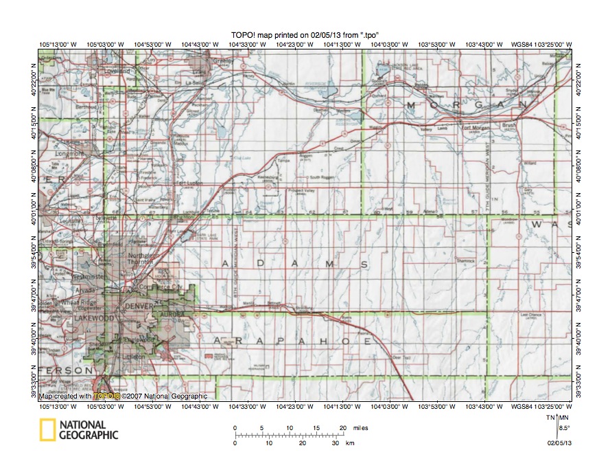
Figure 2: Detailed location map Kiowa Creek-Bijou Creek drainage divide area. United States Geological Survey map digitally presented using National Geographic Society TOPO software.
Figure 2 provides a detailed location map for the northern half of the Kiowa Creek-Bijou Creek drainage divide area on the Colorado Piedmont. The Kiowa Creek-Bijou Creek drainage divide area is a narrow north-to-south oriented drainage divide area and for that reason only the north half can be shown in figure 2. County lines are shown and Morgan, Adams, and Arapahoe Counties are labeled. Weld Could is north of Adams County and west of Morgan County. The South Platte River flows in a north-northeast direction from the south edge of figure 2 (near southwest corner) to Denver and then almost to Greeley (near north edge of figure 2 in Weld County) before turning in a southeast, east, and northeast direction to flow to the northeast corner of figure 2. There are some short northwest oriented South Platte River tributaries in the Denver metropolitan area in Adams and Arapahoe Counties, but otherwise further to the east a large number of north oriented tributaries flow across Adams and Arapahoe Counties to join the southeast and east oriented South Platte River drainage route in Weld and Morgan Counties. Many, but not all of these north oriented drainage routes converge with Kiowa Creek or with Bijou Creek before entering the South Platte River. Kiowa Creek is difficult to identify among the large number of north oriented drainage routes, but flows in a north direction from near the south center edge of figure 2 to between Bennett and Strasburg (on Adams-Arapahoe County line) and then to the southeast corner of Weld County where it flows in a north and northeast direction to Wiggins in Morgan County before joining the South Platte River near Goodrich. Rock Creek is a north oriented Kiowa Creek tributary flowing across the southwest corner of Morgan County. Mule Creek is a north oriented tributary west of Rock Creek and joins Kiowa Creek in the southeast corner of Weld County. The north oriented stream flowing through Strasburg is Comanche Creek, which joins Kiowa Creek near the Weld-Adams County line. The north oriented stream between Kiowa Creek and Comanche Creek in Arapahoe County is Wolf Creek, which joins Comanche Creek in Adams County. West Bijou Creek flows in a north direction from the south edge of figure 2 (east of Kiowa Creek) to Byers in Arapahoe County and then flows in a north-northeast direction into Adams County where it is joined by north-northwest and north oriented East Bijou Creek to form north-northeast oriented Bijou Creek, which then flows into the southwest corner of Morgan County (just east of Hoyt) before turning in a north direction to enter the South Platte River just east of Kiowa Creek. Antelope Creek is a north-northeast oriented tributary originating near Strasburg and joining Bijou Creek in Morgan County and flows near the Mule Creek and Rock Creek headwaters. As will be seen in the topographic maps illustrated and discussed below these north oriented drainage routes originated as south oriented diverging and converging flood flow channels, which were subsequently reversed to flow in north directions.
Rock Creek-Bijou Creek drainage divide area
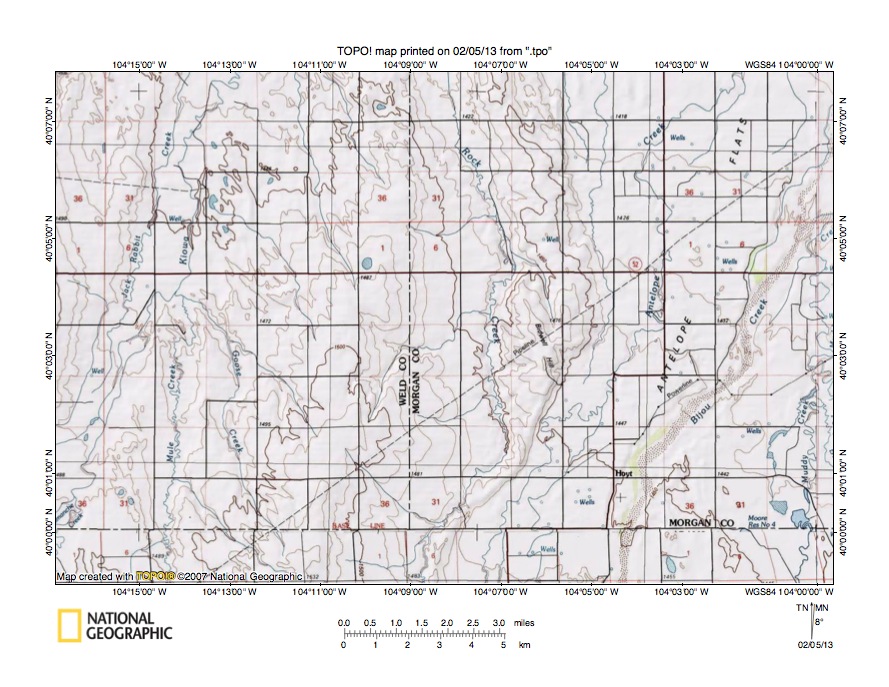
Figure 3: Rock Creek-Bijou Creek drainage divide area. United States Geological Survey map digitally presented using National Geographic Society TOPO software.
Figure 3 provides a topographic map of Rock Creek-Bijou Creek drainage divide area. The map contour interval for figure 3 is 10 meters. Bijou Creek “flows” in a north-northeast direction from the south edge of figure 3 (east half) to the northeast corner of figure 3. Bijou Creek is shown as having a dry stream bed most of the time. North of figure 3 Bijou Creek flows to the east and northeast oriented South Platte River. Antelope Creek flows in a north-northeast direction from the south edge of figure 3 (slightly east of center and west of Bijou Creek) across Antelope Flats to the north edge of figure 3 (east half). Kiowa Creek flows in a north-northeast direction from the west edge of figure 3 (near southwest corner) to the north edge of figure 3 (west half). North of figure 3 Kiowa Creek flows to the east and northeast oriented South Platte River. Mule Creek flows in a north direction from the south edge of figure 3 (west half) to join Kiowa Creek in the west center area of figure 3. Rock Creek flows from the south center edge of figure 3 in a north-northeast and north direction to the north center edge of figure 3 and north of figure 3 joins Kiowa Creek. Note the southeast oriented Rock Creek tributary near the south center edge of figure 3. Bidwell Hill is located on a north-to-south oriented ridge located between the north oriented Rock Creek valley and the north oriented Antelope Creek and Bijou Creek valley. This ridge may be a hogback ridge related to the regional geologic structures. Near the south center edge of figure 3 the ridge almost disappears and the Rock Creek-Antelope Creek drainage divide elevation is between 1460 and 1470 meters. Elevations on Bidwell Hill exceed 1480 meters and elevations along the south edge of figure 3 west of the Rock Creek headwaters rise to more than 1480 meters suggesting there is a shallow north-to-south oriented through valley linking the north-northeast oriented Antelope Creek and Bijou Creek valley with the north oriented Rock Creek valley. This through valley provides evidence of what were once south oriented diverging and converging flood flow channels prior to headward erosion of the east and northeast oriented South Platte River valley north of figure 3. South oriented flood flow on the present day north oriented Rock Creek alignment flowed to south oriented flood flow on the present day north oriented Bijou Creek alignment. Headward erosion of the South Platte River valley north of figure 3 beheaded and reversed the south oriented flood flow channels to create the present day north oriented drainage routes.
Detailed map of Rock Creek-Bijou Creek drainage divide area
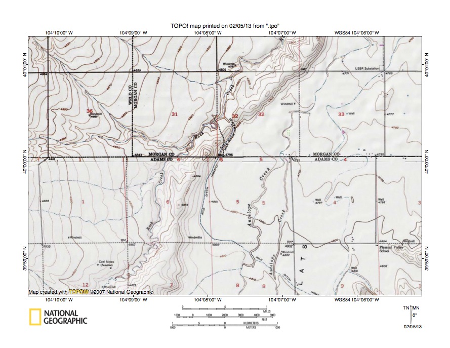
Figure 4: Detailed map of Rock Creek-Bijou Creek drainage divide area. United States Geological Survey map digitally presented using National Geographic Society TOPO software.
Figure 4 provides a detailed topographic map of the Rock Creek-Bijou Creek drainage divide area seen in less detail in figure 3. The map contour interval for figure 4 is 10 feet. Antelope Creek flows from section 8 (along south edge of figure 4) in a north and north-northeast direction to the north edge of figure 4 (east half) and north of figure 4 joins north-northeast and north oriented Bijou Creek, which flows to the east and northeast oriented South Platte River. Rock Creek flows from section 12 (near the south edge of figure 4) in a north-northeast direction to the north edge of figure 4 (east of center). North of figure 4 Rock Creek turns in a north-northwest and north direction to flow to north-northeast oriented Kiowa Creek, which flows to the east and northeast oriented South Platte River. The ridge between Rock Creek and Antelope Creek rises to the north of figure 4 to become Bidwell Hill (seen in figure 3) and reaches an elevation of greater than 4870 feet. The elevation where the Nile Ditch crosses drainage divide between Rock Creek and Antelope Creek in section 32 is between 4800 and 4810 feet. Elevations in section 6 to the south reach 4873 feet and further to the south the ridge between Rock Creek and Antelope Creek rises even higher. These elevations suggest the through valley where Nile Ditch crosses the drainage divide is at least 60 feet deep. Just west of the through valley two southeast oriented streams join north-northeast oriented Rock Creek as barbed tributaries. The through valley and barbed tributaries are evidence of south oriented flood flow that once crossed the region. Prior to the flood flow reversal south oriented floodwaters from the present day north oriented Rock Creek alignment (north of figure 4) converged with south-southwest oriented floodwaters on the Antelope Creek alignment and then flowed in a south direction on the present day north oriented Bijou Creek alignment with floodwaters flowing to what at that time was the newly eroded east oriented Arkansas River valley. Headward erosion of the much deeper east and northeast oriented South Platte River valley north of figure 4 beheaded and reversed the south oriented flood flow channels to create the present day north oriented drainage routes.
Mule Creek-Bijou Creek drainage divide area

Figure 5: Mule Creek Bijou Creek drainage divide area. United States Geological Survey map digitally presented using National Geographic Society TOPO software.
Figure 5 illustrates a topographic map of the Mule Creek-Bijou Creek drainage divide area south and slightly west of figure 3 and there is no overlap area with figure 3. The map contour interval for figure 5 is 10 meters. Kiowa Creek flows in a north and north-northeast direction from the west edge of figure 5 (near southwest corner) to the north edge of figure 5 (west half). North of figure 5 Kiowa Creek flows to the east and northeast oriented South Platte River. Comanche Creek flows in a north direction from the south edge of figure 5 (west half) to the north edge of figure 5 (west half) and north of figure 5 joins Kiowa Creek. Wolf Creek is the north-northeast Comanche Creek tributary flowing from near the southwest corner of figure 5. Bijou Creek “flows” in an east-northeast and north-northeast direction from the south edge of figure 5 (east half) to the northeast corner of figure 5 and north of figure 5 flows to the east and northeast oriented South Platte River. Antelope Creek originates in the southeast quadrant of figure 5 (west of Bijou Creek) and flows in a north-northeast direction to the north edge of figure 5 (east half). North of figure 5 Antelope Creek joins Bijou Creek. Rock Creek originates in the northeast quadrant of figure 5 and flows in a north-northeast direction to the north edge of figure 5 (east half-west of Antelope Creek) and north of figure 5 turns to flow in a north-northwest and north direction to join Kiowa Creek. Mule Creek flows in a north and north-northwest direction from the south center area of figure 5 to the north edge of figure 5 (west of center) and north of figure 5 joins Kiowa Creek. Ridges between Mule Creek and Rock Creek and between Comanche Creek and Bijou Creek may be hog back ridges related to the regional geologic structures, but they are also separated by and even crossed by water-eroded valleys. Note how the north oriented Mule Creek valley is linked by shallow through valleys with southeast oriented and barbed tributaries flowing to north-northeast oriented Antelope Creek. The shallow through valleys and barbed tributaries provide evidence of the diverging and converging south oriented flood flow channels that once crossed the region prior to headward erosion of the much deeper east and northeast oriented South Platte River valley (north of figure 5). Headward erosion of the South Platte River valley beheaded and reversed the south oriented flood flow in sequence from east to west to create the north oriented drainage routes seen today. The flood flow reversal may have been aided by ice sheet related crustal warping that may have been raising regions south of figure 5. The reversal of flood flow on the Bijou-Antelope Creek alignment occurred before the reversal of flood flow on the Kiowa-Mule Creek alignment, which meant reversed flood flow on the Bijou-Antelope Creek alignment captured south oriented flood flow still moving on the Kiowa-Mule Creek alignment. This captured flood flow helped erode the Bijou-Antelope Creek valley. Headward erosion of the South Platte River valley subsequently beheaded and reversed flood flow on the Kiowa-Mule Creek alignment and the capture process was repeated with flood flow channels further to the west.
Detailed map of Mule Creek-Antelope Creek drainage divide area
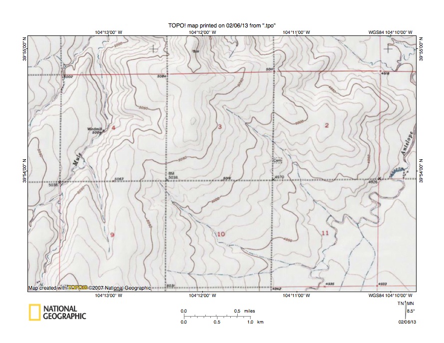
Figure 6: Detailed map of Mule Creek-Antelope Creek drainage divide area. United States Geological Survey map digitally presented using National Geographic Society TOPO software.
Figure 6 provides a detailed topographic map of the Mule Creek-Antelope Creek drainage divide area seen in less detail in figure 5. The map contour interval for figure 6 is 10 feet. Mule Creek flows in a north, north-northeast, and north direction from near the southwest corner of figure 6 to the north edge of figure 6 (west half) and north of figure 6 flows to north-northeast oriented Kiowa Creek, which then flows to the east and northeast oriented South Platte River. Antelope Creek flows in a north-northeast direction from the south edge of figure 6 (east half) across section 11 and then to the east edge of figure 6. East and north of figure 6 Antelope Creek flows to north-northeast and north oriented Bijou Creek, which flows to the east and southeast oriented South Platte River. Antelope Creek is joined by three southeast oriented and barbed tributaries with one of the barbed tributaries being in the northeast corner area of figure 6, a second barbed tributary flowing from section 3 to join Antelope Creek in section 11, and the third barbed tributary flowing through section 10 to join Antelope Creek in the south half of section 11. A through valley in the southeast quadrant of section 4 links the north oriented Mule Creek valley with the southeast oriented Antelope Creek tributary in section 10. The through valley floor elevation is between 5050 and 5060 feet. Elevations along the drainage divide both north and south of the through valley exceed 5110 feet suggesting the through valley is at least 50 feet deep. The through valley is a water-eroded valley and was eroded by south oriented flood flow moving on the present day north oriented Mule Creek alignment to a south oriented flood flow channel on the present day north oriented Antelope Creek alignment prior to headward erosion of the South Platte River valley north of figure 6. Headward erosion of the South Platte River valley beheaded and reversed the south oriented flood flow channels to create the north oriented drainage routes seen today. Flood flow channels were beheaded in sequence from east to west and flood flow in the Antelope Creek valley was reversed while south oriented flood flow still was moving on the Mule Creek alignment and the reversed flood flow on the Antelope Creek alignment captured south oriented flood flow from the Mule Creek alignment. This capture of flood flow helped erode the north oriented Antelope Creek valley. Subsequently headward erosion of the South Platte River valley beheaded and reversed flood flow on the Mule Creek alignment and the capture process was repeated with flood flow channels further to the west.
Box Elder Creek-West Bijou Creek drainage divide area
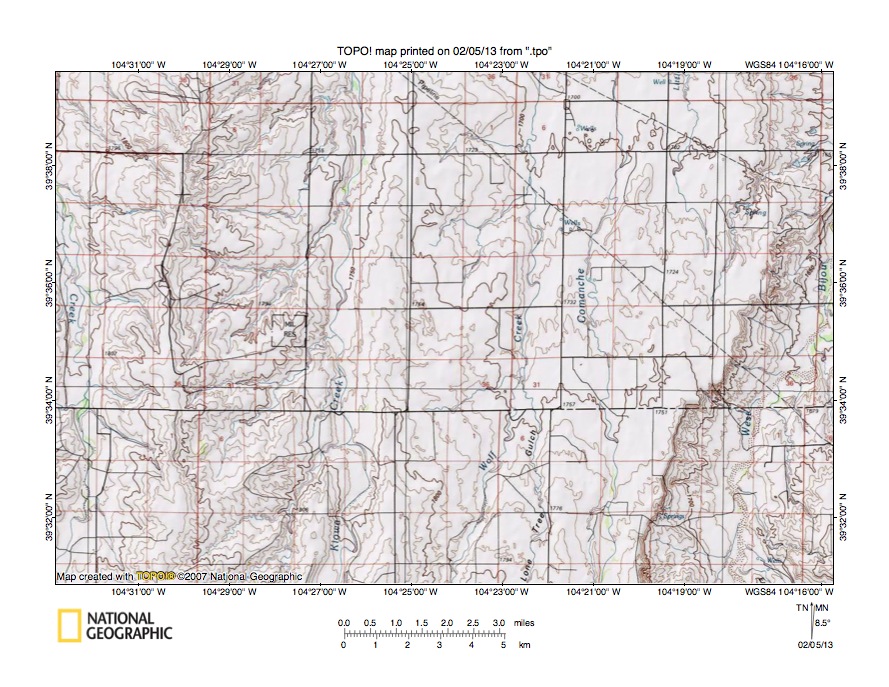
Figure 7: Box Elder Creek-West Bijou Creek drainage divide area. United States Geological Survey map digitally presented using National Geographic Society TOPO software.
Figure 7 illustrates a topographic map of the Box Elder Creek-West Bijou Creek drainage divide area south of figure 5 and there is no overlap area with figure 5. The map contour interval for figure 7 is 10 meters. Box Elder Creek flows in a north direction along and across the west edge of figure 7. North of figure 7 Box Elder Creek flows in a north direction to reach the southeast, east, and northeast oriented South Platte River. Kiowa Creek flows in a north direction from the south edge of figure 7 (west of center) to the north edge of figure 7 (west of center) and north of figure 7 Kiowa Creek flows in a north and north-northeast direction to join the east and northeast oriented South Platte River. Wolf Creek flows in a north-northeast and north direction from the south center edge of figure 7 to the north edge of figure 7 (east of center). North of figure 7 Wolf Creek joins north oriented Comanche Creek, which then flows to Kiowa Creek. Comanche Creek flows in a north direction from the south edge of figure 7 (east half) to the north edge of figure 7 (east half) and north of figure 7 joins north-northeast oriented Kiowa Creek. West Bijou Creek “flows” in a north and north-northeast direction from the south edge of figure 7 (near southeast corner) to the east edge of figure 7 (north half). East and north of figure 7 West Bijou Creek joins East Bijou Creek to form north-northeast and north oriented Bijou Creek, which “flows” to the east and northeast oriented South Platte River. Ridges west of Kiowa Creek and west of West Bijou Creek may be hogback ridges related to the underlying geologic structure. However, valleys between the ridges are water-eroded valleys and were eroded by south oriented flood flow moving to what at that time was the newly eroded east oriented Arkansas River valley south of figure 7. Headward erosion of the much deeper southeast, east, and northeast oriented South Platte River valley (north of figure 7) beheaded and reversed the south oriented flood flow channels to create the north oriented drainage routes seen today. Through valleys crossing drainage divides between the north oriented drainage routes seen on figure 7 are defined by one contour line on a side and are not obvious. However the north oriented West Bijou Creek valley is significantly deeper than the adjacent north oriented valleys just to the west, which suggests it captured significant flood flow at some location south of figure 7. The capture location is shown in figure 9.
Detailed map of Kiowa Creek-Wolf Creek drainage divide area

Figure 8: Detailed map of Kiowa Creek-Wolf Creek drainage divide area. United States Geological Survey map digitally presented using National Geographic Society TOPO software.
Figure 8 provides a detailed topographic map of the Kiowa Creek-Wolf Creek drainage divide seen in less detail figure 7. The map contour interval for figure 8 is 10 feet. Kiowa Creek flows in a north direction near the west edge of figure 8. North of figure 8 Kiowa Creek flows in a north and north-northeast direction to join the east and northeast oriented South Platte River. Comanche Creek flows in a north direction near the east edge of figure 8 and north of figure 8 flows in a north direction to join north-northeast oriented Kiowa Creek. Wolf Creek flows in a north direction from the south edge of figure 8 (east half) to the north edge of figure 8 (east half) and north of figure 8 Wolf Creek joins north oriented Comanche Creek. The Kiowa Creek-Wolf Creek drainage divide is crossed by shallow west-to-east oriented through valleys, which were not easily seen on the less detailed figure 7 map. For example in section 3 the Telephone Line is located in a through valley defined by two 10-foot contour lines on the north side and at least three contour lines on the south side. The through valley links an east-southeast oriented Wolf Creek tributary valley with the north oriented Wolf Creek (and Comanche Creek) valley. The through valley was probably eroded by south oriented flood flow on the Kiowa Creek alignment moving in an east direction to reversed flood flow on the Wolf Creek alignment. To understand how this situation developed remember north of figure 8 Kiowa Creek turns in a north-northeast direction before it is joined by north oriented Comanche Creek. Headward erosion of the north-northeast oriented Kiowa Creek valley north of figure 8 beheaded and reversed flood flow on the Comanche Creek and Wolf Creek alignments (seen in figure 8) before it beheaded and reversed south oriented flood flow on the Kiowa Creek alignment (seen in figure 8). For a short period of time floodwaters were flowing in a north direction on the Wolf and Comanche Creek alignments (seen in figure 8) while floodwaters were still flowing in a south direction on the Kiowa Creek alignment (seen in figure 8). Headward erosion of the north-northeast oriented Kiowa Creek valley then beheaded and reversed the flood flow on the Kiowa Creek alignment (seen in figure 8) to create the north oriented Kiowa Creek drainage route (seen in figure 8).
Kiowa Creek-West Bijou Creek drainage divide area

Figure 9: Kiowa Creek-West Bijou Creek drainage divide area. United States Geological Survey map digitally presented using National Geographic Society TOPO software.
Figure 9 illustrates topographic map of the Kiowa Creek-West Bijou Creek drainage divide area south of figure 7 and there is no overlap area with figure 7. The map contour interval for figure 9 is 50 meters. Kiowa Creek flows in a north-northeast and north direction from near the southwest corner of figure 9 to the north edge of figure 9 (west half-near highway). North of figure 9 Kiowa Creek flows in a north and north-northeast direction to eventually reach the east and northeast oriented South Platte River with water eventually reaching the Platte, Missouri, and Mississippi Rivers. The north and northeast oriented stream flowing across the northwest corner of figure 9 is West Kiowa Creek, which joins Kiowa Creek north of figure 9. Rattlesnake Butte is a labeled high point near the south edge of the southwest quadrant of figure 9. West Bijou Creek originates north of Rattlesnake Butte and flows in an east, north-northwest, north-northeast, and east direction to the center of figure 9 before turning to flow in a northeast direction through the Bijou Basin to the north edge of figure 9 (east half). North of figure 9 West Bijou Creek flows in north-northeast and north directions to eventually join East Bijou Creek and to form north-northeast and north oriented Bijou Creek, which flows to the east and northeast oriented South Platte River. Big Sandy Creek originates just north of the south center edge of figure 9 and flows in an east, east-northeast, and east direction to the east edge of figure 9 (near southeast corner). East of figure 9 Big Sandy Creek flows in an east-northeast, north-northeast, southeast, and south direction to eventually join the east oriented Arkansas River, which eventually flows directly to the Mississippi River. Note how a through valley extends from the north oriented Kiowa Creek valley near the Landing Strip to the east oriented West Bijou Creek valley in section 31. The through valley is defined by one 50-meter contour line and was eroded by southeast oriented flood flow moving from a yet to be headed south oriented flood flow channel on the present day north oriented Kiowa Creek alignment to a newly beheaded and reversed flood flow channel on the West Bijou Creek alignment. Before headward erosion of the northeast oriented Bijou Basin valley the flood flow was moving to the east oriented Big Sandy Creek headwaters valley. A through valley south of Fremont Fort links a north-northwest oriented West Bijou Creek tributary valley with the east oriented Big Sandy Creek valley. Prior to the reversal of flood flow on the West Bijou Creek alignment floodwaters were flowing in south directions to actively eroding south oriented Arkansas River tributary valleys. Immediately south of figure 9 are headwaters of south oriented Arkansas River tributaries. Figures 9 and 10 in the South Platte River-Arkansas River drainage divide area in northern El Paso County essay show the south oriented Arkansas River tributaries located just south of Rattlesnake Butte.
Detailed map of Kiowa Creek-West Bijou Creek drainage divide area
Figure 10: Detailed map of Kiowa Creek-West Bijou Creek drainage divide area. United States Geological Survey map digitally presented using National Geographic Society TOPO software.
Figure 10 provides a detailed topographic map of the Kiowa Creek-West Bijou Creek drainage divide area seen in less detail in figure 9. The map contour interval for figure 10 is 20 feet. Kiowa Creek “flows” in a north-northeast and north direction from the west edge of figure 10 (south half) to the north edge of figure 10 (in northwest corner area). North of figure 10 Kiowa Creek “flows” in north and north-northeast directions to eventually join the east and northeast oriented South Platte River. West Bijou Creek “flows” in a northeast and east-southeast direction from the south edge of figure 10 (slightly west of center) to the east edge of figure 10 (in southeast corner region). East of figure 10 West Bijou Creek turns to “flow” in northeast and north-northeast directions to eventually join East Bijou Creek and to form north-northeast and north oriented Bijou Creek, which “flows” to the east and northeast oriented South Platte River. A through valley extending across section 25 and the northeast corner of section 25 links the north oriented Kiowa Creek valley with the West Bijou Creek valley and is drained by a west-northwest oriented Kiowa Creek tributary. The through valley floor elevation at the Kiowa Creek-West Bijou Creek drainage divide in the southwest corner of section 30 and southeast corner of section 25 is between 7020 and 7040 feet. Elevations north and south of the through valley rise to more than 7220 feet suggesting the through valley is at least 160 feet deep. The through valley is a water-eroded valley and was eroded by a southeast oriented flood flow channel diverging from a south oriented flood flow channel on the Kiowa Creek alignment with the diverging southeast oriented flood flow channel moving floodwaters to the east-southeast oriented West Bijou Creek, which east of figure 10 drained in a northeast direction to what at that time was the newly reversed West Bijou Creek-Bijou Creek drainage route. Today the Kiowa Creek-West Bijou Creek drainage divide on the through valley is approximately 120 feet higher than the Kiowa Creek valley floor at the point where the through valley diverges from the Kiowa Creek valley. This elevation difference can be explained in one of three ways. First, flood flow in the Kiowa Creek valley (moving both in south directions and later after being beheaded and reversed in north directions) eroded the Kiowa Creek valley deeper, which then beheaded and reversed drainage in the southeast oriented flood flow to create the west-northwest oriented Kiowa Creek tributary. Second, crustal warping in the region raised areas in sections 25 and 30 relative to the region where the through valley diverges from the Kiowa Creek valley. The third possibility is some combination of the first two explanations. Whatever explanation is correct floodwaters at one time flowed from the Kiowa Creek valley to the West Bijou Creek valley.
Additional information and sources of maps studied
This essay has provided only a sample of the detailed topographic map evidence supporting the flood erosion interpretation. Many additional illustrations could be provided. Readers are encouraged to look at mosaics of detailed topographic maps to see the abundance of available data. Maps used in this study were created and published by the United States Geologic Survey and can be obtained directly from the United States Geological Survey and/or from dealers offering United States Geological Survey maps. Hard copy maps can also be observed at United States Geological Survey map depositories, which are located throughout the United States and elsewhere. Illustrations used here were created using National Geographic Society TOPO software and digital map data. TOPO software and map data can be obtained from the National Geographic Society and/or dealers offering National Geographic Society digital map data.

Leave a comment