
Abstract:
This essay uses topographic map evidence to interpret landform origins in the Big Sandy Creek-Smoky Hill River drainage divide area in Cheyenne County, Colorado. Big Sandy Creek flows in a southeast direction into Cheyenne County and once in Cheyenne County turns to flow in a south-southeast direction and south of Cheyenne County flows in a south direction to join the east oriented Arkansas River. Smoky Hill River headwaters and tributaries originate in Cheyenne County both north and east of where Big Sandy Creek turns from flowing in a southeast direction to flowing in a south-southeast and south direction. The Smoky Hill River valley and its tributary valleys eroded headward into Cheyenne County to capture massive south and southeast oriented flood flow at approximately the same time as the Big Sandy Creek valley and its tributary valleys eroded headward into Cheyenne County to capture the same flood flow. Floodwaters were derived from the western margin of a thick North American ice sheet and flowed from western Canada to and across Colorado at a time when ice sheet related crustal warping was raising Colorado and adjacent states and when deep valleys were eroding headward into Colorado to capture the immense melt water flood flow. Topographic map evidence documents headward erosion of south oriented Big Sandy Creek tributary valleys beheaded southeast oriented flood flow routes to actively eroding Smoky Hill River tributary valleys while headward erosion of the North Fork Smoky Hill River valley beheaded south oriented flood flow routes to actively eroding south oriented Big Sandy Creek tributary valleys, which ended south oriented flood flow to the Big Sandy Creek valley. Headward erosion of the North Fork Smoky Hill River valley did not behead southeast oriented flood flow routes to the south oriented Big Sandy Creek valley and as result the Big Sandy Creek valley was able to erode headward along southeast oriented flood flow channels, which explains the Big Sandy Creek change in direction in Cheyenne County. Evidence for former flood flow channels seen on topographic maps includes multiple through valleys crossing present day drainage divides, which suggests the region was once crossed by an ever-changing anastomosing complex of diverging and converging flood flow channels.
Preface
The following interpretation of detailed topographic map evidence is one of a series of essays describing similar evidence for all major drainage divides contained within the Missouri River drainage basin and for all major drainage divides with adjacent drainage basins. The research project is interpreting evidence in the context of a previously unexplored deep glacial erosion paradigm, which is fundamentally different from most commonly accepted North American glacial history interpretations. Project essays are listed on the sidebar category list under their appropriate Missouri River tributary drainage basin, Missouri River segment drainage basin (by state), and/or state in which the Missouri River drainage basin is located.
Introduction
The purpose of this essay is to use topographic map interpretation methods to explore the Big Sandy Creek-Smoky Hill River drainage divide area landform origins in Cheyenne County, Colorado. Map interpretation methods can be used to unravel many geomorphic events leading up to formation of present-day drainage routes and development of other landform features. While each detailed topographic map feature provides detailed evidence to be explained, the solution must be consistent with explanations for adjacent area map evidence as well as solutions to big picture map evidence puzzles. I invite readers to improve upon my solutions and/or to propose alternate solutions that better explain evidence and are also consistent with adjacent map area and big-picture evidence. Readers may do so either by making comments here or by writing and publishing their own essays and then by leaving a link to those essays in a comment here.
This essay is also exploring a new geomorphology paradigm in which erosional landforms are interpreted as evidence left by immense glacial melt water floods. Implied in that interpretation is the immense floods were derived from a thick North American ice sheet that created a deep “hole” in the North American continent and also melted fast. The previously unexplored paradigm being tested in this and other Missouri River drainage basin landform origins research project essays is a thick North American ice sheet, comparable in thickness to the Antarctic ice sheet, occupied the North American region usually recognized to have been glaciated, and through its weight and erosive actions created a deep North American “hole”. The southwestern rim of that deep “hole” is today preserved in the high Rocky Mountains. The ice sheet through its weight and deep erosion (and perhaps deposition along major south-oriented melt water flow routes) caused significant crustal warping and tectonic change, through its action of melting fast produced immense floods that flowed across the continent, and through its action of melting fast systematically opened up space in the ice sheet created “hole” so headward erosion of newly developed north-oriented drainage systems captured immense south-oriented melt water floods and diverted immense melt water floods north into space the ice sheet had once occupied.
If this previously unexplored paradigm is correct the geographic region explored by this essay should contain evidence of immense floods that were captured by headward erosion of new valley systems so as to cause the floods to flow in a different direction. Ability of this previously unexplored paradigm to explain Big Sandy Creek-Smoky Hill River drainage divide area landform evidence in Cheyenne County, Colorado will be regarded as evidence supporting the “thick ice sheet that melted fast” paradigm.
Big Sandy Creek-Smoky Hill River drainage divide area location map
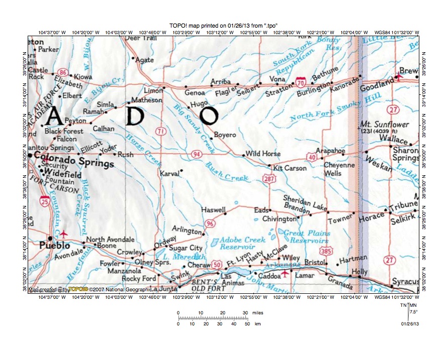
Figure 1: Big Sandy Creek-Smoky Hill River drainage divide area location map (select and click on maps to enlarge). National Geographic Society map digitally presented using National Geographic Society TOPO software.
Figure 1 provides a location map for the Big Sandy Creek-Smoky Hill River drainage divide area in Cheyenne County, Colorado and illustrates a region in eastern Colorado with a thin strip of western Kansas to the east. Colorado Springs is located near the west center edge of figure 1 and Pueblo is located near the southwest corner of figure 1. The Arkansas River flows in an east-southeast and east direction from Pueblo to Syracuse near the southeast corner of figure 1. South and east of figure 1 the Arkansas River eventually flows to the Mississippi River. Big Sandy Creek originates north and east of Colorado Springs and flows in an east-northeast and then north-northeast direction through Ramah and Simla before turning in a southeast direction to flow to Limon, Hugo, Boyero, Wild Horse, and Kit Carson and then to turn in a south direction to join the east oriented Arkansas River. Rush Creek is a southeast oriented Big Sandy Creek tributary with southeast oriented headwaters originating south of the northeast oriented Big Sandy Creek headwaters. Relatively few tributaries are shown joining Big Sandy Creek from the north and east. Instead the headwaters of northeast and east oriented drainage routes originate near the southeast oriented Big Sandy Creek segment. The northeast oriented South Fork Republican River originates east of Hugo and flows to the north edge of figure 1 (east half). North and east of figure 1 the South Fork Republican River flows into southern Nebraska to join the east oriented Republican River with water eventually reaching the Kansas, Missouri, and Mississippi Rivers. The North Fork Smoky Hill River originates north of Kit Carson and flows in an east-northeast and east direction to the east edge of figure 1 (north half). East of figure 1 the North Fork Smoky Hill River flows to the Smoky Hill River with water eventually reaching the Kansas, Missouri, and Mississippi Rivers. The Smoky Hill River (unlabeled in figure 1) is located south of the North Fork Smoky Hill River and flows in an east direction to the east edge of figure 1 (near Wallace). South of the Smoky Hill River is Ladder Creek which is a Smoky Hill River tributary. The unlabeled east-southeast oriented stream south of Ladder Creek is White Woman Creek, which east of figure 1 disappears as a surface drainage route. The Big Sandy Creek-Smoky Hill River drainage divide area investigated in this essay includes the North Fork Smoky Hill River-Big Sandy Creek drainage divide north of Kit Carson and extends south along the Big Sandy Creek valley wall to the Ladder Creek headwaters area.
Drainage routes in Colorado and adjacent states originated during immense melt water floods from the western margin of a thick North American ice sheet. Floodwaters flowed to and across Colorado at a time when ice sheet related crustal warping was raising Colorado and adjacent regions and when deep valleys were eroding headward into the region to capture the massive south oriented melt water floods. Headward erosion of the east oriented Arkansas River valley first captured the south oriented flood flow in figure 1 and south oriented tributary valleys eroded headward from the newly eroded Arkansas River valley. At approximately the same time as the south oriented Big Sandy Creek valley segment was eroding headward from the newly eroded Arkansas River valley east oriented Smoky Hill River tributary and headwaters valleys eroded headward into the region and began to compete the Big Sandy Creek valley for the south oriented flood flow. Headward erosion of the deeper Big Sandy Creek valley and tributary valleys first beheaded southeast oriented flood flow routes to actively eroding Smoky River tributary and headwaters valleys and next North Fork Smoky Hill River headwaters valleys beheaded south oriented flood flow channels to the actively eroding Big Sandy Creek valley, which meant the only floodwaters entering the Big Sandy Creek valley then came from the northwest. As a result the deep Big Sandy Creek valley could only erode headward in a northwest direction. Headward erosion of the South Fork Republican River valley and its tributary valleys also beheaded south oriented flood flow to the deep Big Sandy Creek valley, but also did not block the southeast oriented flood flow so the deep Big Sandy Creek valley continued to erode headward in a northwest direction. When the deep and southeast oriented Big Sandy Creek valley eroded far enough west that it could again capture south oriented flood flow channels (west of Limon) it beheaded a less deep south oriented flood flow channel causing floodwaters on the north end of the beheaded flood flow channel to reverse flow direction to flow to the deeper southeast oriented Big Sandy Creek valley and created the north-northeast oriented Big Sandy Creek valley segment. The east-northeast oriented Big Sandy Creek valley segment then eroded headward from the newly formed north-northeast oriented Big Sandy Creek valley segment to capture additional south oriented flood flow channels. Headward erosion of the deep east and northeast oriented South Platte River valley (north of figure 1) then beheaded and reversed the south oriented flood flow channels flowing to the newly eroded east-northeast and north-northeast oriented Big Sandy Creek valley and created north oriented South Platte River tributary drainage routes seen in the northwest corner of figure 1 (e.g. West and East Bijou Creeks).
Detailed location map for Big Sandy Creek-Smoky Hill River drainage divide area
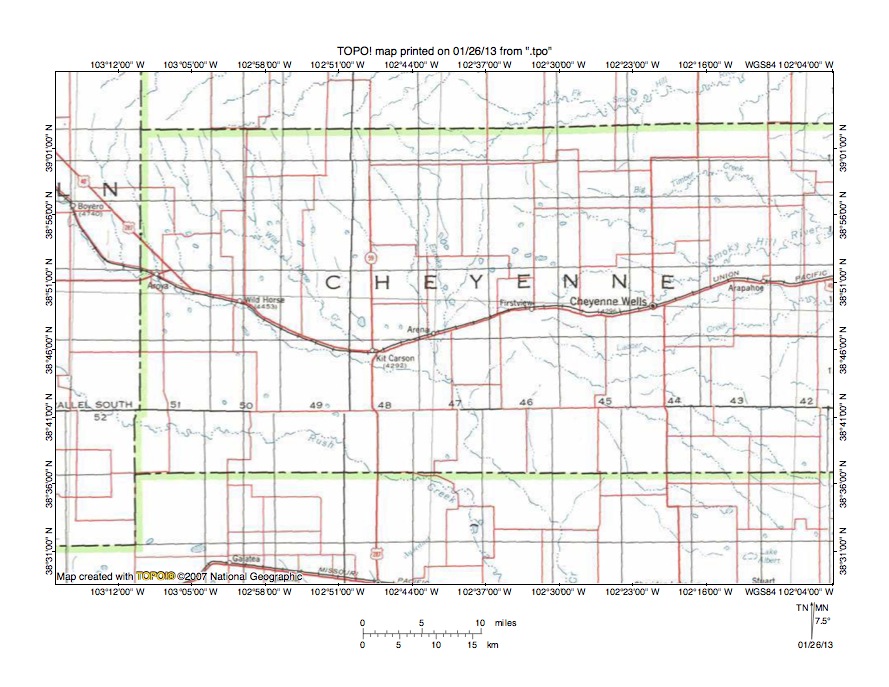
Figure 2: Detailed location map Big Sandy Creek-Smoky Hill River drainage divide area. United States Geological Survey map digitally presented using National Geographic Society TOPO software.
Figure 2 provides a detailed location map for the Big Sandy Creek-Smoky Hill River drainage divide area in Cheyenne County, Colorado. County lines are shown and Cheyenne County is labeled. The north-to-south oriented Colorado-Kansas state line is located just east of figure 2. Boyero is a town located near the west edge of figure 2 (north half). Big Sandy Creek flows in a southeast direction from Boyero to Aroya, Wild Horse, and Kit Carson before turning in a south-southeast direction to flow to the south edge of figure 2 (east of center). South of figure 2 Big Sandy Creek flows in a south direction to the east oriented Arkansas River, which eventually reaches the Mississippi River. Wild Horse Creek is a southeast oriented tributary joining Big Sandy Creek near Kit Carson. Arena is a town near Kit Carson and Eureka Creek is a south oriented Big Sandy Creek tributary flowing just east of Arena. The North Fork Smoky Hill River originates north of the Eureka Creek headwaters and flows in an east-northeast direction to the north edge of figure 2 (near northeast corner). North and east of figure 2 the North Fork Smoky Hill River flows to the Smoky Hill River with water eventually reaching the Kansas, Missouri, and Mississippi Rivers. Northeast oriented streams originating north of the southeast oriented Wild Horse Creek headwaters are tributaries to the northeast oriented South Fork Republican River with water eventually reaching the Republican, Kansas, Missouri, and Mississippi Rivers. The Smoky Hill River originates north of Firstview and flows in an east-southeast and east-northeast direction to the east edge of figure 2 (north of center) and east of figure 2 flows in an east direction to eventually join the Kansas River with water flowing to the Missouri and Mississippi Rivers. The unlabeled Smoky Hill River tributary flowing near Cheyenne Wells is Willow Creek, which is an important stream in this essay. Ladder Creek originates just south of Firstview and flows in an east direction to the east center edge of figure 2. East of figure 2 Ladder Creek flows in an east, southeast, east, and north direction to join the Smoky Hill River. The unlabeled east-southeast, east, and east-southeast oriented stream immediately south of Ladder Creek is South Ladder Creek, which east of figure 2 joins Ladder Creek. Southeast oriented streams located south of south of South Ladder Creek are headwaters of White Woman Creek, which east of figure 2 disappears as a surface stream. Note how headward erosion of the east oriented North Fork Smoky Hill River valley beheaded south oriented flood flow to the south oriented Eureka Creek valley, which drains to the south-southeast and south oriented Big Sandy Creek valley. Also note how headward erosion of the northeast oriented South Fork Republican River tributary valleys beheaded southeast oriented flood flow routes to the southeast oriented Wild Horse Creek valley, but did not behead southeast oriented flood flow on the Big Sandy Creek alignment.
North Fork Smoky Hill River-Big Sandy Creek drainage divide area

Figure 3: North Fork Smoky Hill River-Big Sandy Creek drainage divide area. United States Geological Survey map digitally presented using National Geographic Society TOPO software.
Figure 3 provides a topographic map of North Fork Smoky Hill River-Big Sandy Creek drainage divide area. The map contour interval for figure 3 is 10 meters. The North Fork Smoky Hill River flows in an east-southeast, east, and northeast direction from the west edge of figure 3 (near northwest corner) to the north edge of figure 3 (near northeast corner). North and east of figure 3 the North Fork Smoky Hill River flows to the Smoky Hill River with water then flowing to Kansas, Missouri, and Mississippi Rivers. Little Spring Creek flows in a south-southeast direction from the west edge of figure 3 (just south of the North Fork Smoky Hill River) to the south edge of figure 3 (west half). South of figure 3 Little Spring Creek joins Big Spring Creek and Eureka Creek to flow in a south direction to join south-southeast and south oriented Big Sandy Creek, which flows to the east oriented Arkansas River, which eventually flows directly to the Mississippi River. The unlabeled south oriented stream flowing through sections 31 and 6 in the southwest quadrant of figure 3 is Eureka Creek, which south of figure 3 joins south oriented Big Spring Creek to flow to south-southeast and south oriented Big Sandy Creek. Other south oriented streams flowing to the south edge of figure 3 are either Eureka Creek tributaries or flow towards Eureka Creek before disappearing as surface streams. Landsman Hill is a labeled high point on the North Fork Smoky Hill River-Big Sandy Creek drainage divide located in the southeast quadrant of figure 3. Note how north-to-south oriented through valleys cross the drainage divide and link the south oriented stream valleys with the east and northeast oriented North Fork Smoky Hill River valley and/or with north oriented North Fork Smoky Hill River tributary valleys. The deepest through valleys are defined by two 10-meter contour lines on a side and could be between 10 and 30 meters deep. The through valleys were eroded by diverging and converging south oriented flood flow channels flowing to the south oriented Big Sandy Creek valley to the south of figure 3. Headward erosion of the North Fork Smoky Hill River valley captured the south oriented flood flow. Floodwaters on north ends of some of the beheaded flow channels reversed flow direction to flow to the deeper North Fork Smoky Hill River valley and to create the north oriented North Fork Smoky Hill River tributary drainage routes seen near the east edge of figure 3.
Detailed map of North Fork Smoky Hill River-Big Sandy Creek drainage divide area
Figure 4: Detailed map of North Fork Smoky Hill River-Big Sandy Creek drainage divide area. United States Geological Survey map digitally presented using National Geographic Society TOPO software.
Figure 4 provides a detailed topographic map of the North Fork Smoky Hill River-Big Sandy Creek drainage divide area seen in less detail in figure 3. The map contour interval for figure 4 is 10 feet. Landsman Hill is located near the southeast corner of figure 4. North oriented streams flowing to the north edge of figure 4 are tributaries to the east and northeast oriented North Fork Smoky Hill River. South oriented streams flowing to the south edge of figure 4 disappear as surface streams south of figure 4, but are headed toward the south oriented Big Sandy Creek valley so are treated here as Big Sandy Creek tributaries. North-to-south oriented through valleys cross the North Fork Smoky Hill River-Big Sandy Creek drainage divide and link the north oriented North Fork Smoky Hill River tributary valleys with the south oriented Big Sandy Creek tributary valleys. The deepest through valleys are defined by four 10-foot contour lines on each side suggesting they are between 30 and 50 feet deep. The through valleys were eroded by diverging and converging south oriented flood flow channels supplying floodwaters to the actively eroding south oriented Big Sandy Creek valley. Headward erosion of the east and northeast oriented North Fork Smoky Hill River valley beheaded the south oriented flood flow channels. Floodwaters on north ends of the beheaded flood flow channels reversed flow direction to flow to the deeper North Fork Smoky Hill River valley and to create the north oriented North Fork Smoky Hill River tributary drainage routes. When south oriented flood flow to the actively eroding Big Sandy Creek valley was beheaded the only flood flow reaching the deep Big Sandy Creek valley was flowing in a southeast direction from the northwest. As a result the Big Sandy Creek valley then eroded headward along the southeast oriented flood flow which was still entering the deep Big Sandy Creek valley, which accounts for the Big Sandy Creek direction change in Cheyenne County.
Eureka Creek-Willow Creek drainage divide area
Figure 5: Eureka Creek-Willow Creek drainage divide area. United States Geological Survey map digitally presented using National Geographic Society TOPO software.
Figure 5 illustrates a topographic map of the Eureka Creek-Willow Creek drainage divide area east and south of figure 3 and includes an overlap area with figure 3. The map contour interval for figure 5 is 10 meters. Cheyenne Wells is the town located near the southeast corner of figure 5. Landsman Hill is located near the northwest corner of figure 5. The Smoky Hill River originates near Landsman Hill and flows in an east and east-southeast direction to the east edge of figure 5 (slightly north of center). East of figure 5 the Smoky Hill River flows in an east direction and water eventually reaches the Kansas, Missouri, and Mississippi Rivers. Willow Creek originates near the center of figure 5 and flows in a southeast and east direction to the east edge of figure 5 (just north of Cheyenne Wells). East of figure 5 Willow Creek flows to the Smoky Hill River. A south-southwest oriented stream originates at Landsman Hill and flows to the west edge of figure 5 (slightly north of center) and is aimed toward the south oriented Eureka Creek valley (west of figure 5), which drains to the south oriented Big Sandy Creek valley, which drains to the east oriented Arkansas River. Several intermittent lakes are located in a west-to-east oriented through valley linking an east oriented Willow Creek tributary valley with the south oriented Eureka Creek valley (west of figure 5). The through valley floor elevation is between 1350 and 1360 meters. Elevations south of the through valley rise to 1395 meters and Landsman Hill has an elevation of 1418 meters suggesting the through valley is at least 35 meters deep. The through valley was probably eroded by east oriented flood flow, which had been captured by headward erosion of the east oriented Willow Creek tributary valley, which was eroding headward slightly in advance of the Smoky Hill River valley to the north. The east oriented Willow Creek valley apparently did successfully capture significant south oriented flood flow west of figure 5, but headward erosion of the deeper south oriented Big Sandy Creek tributary valleys subsequently was able to recapture that south oriented flood flow and to behead the east oriented Willow Creek valley. Shortly thereafter headward erosion of the North Fork Smoky Hill River valley beheaded the south oriented flood flow channels to the Big Sandy Creek valley and ended all flood flow moving in a south direction to the Big Sandy Creek valley, but did not end southeast oriented flood flow flowing into the Big Sandy Creek valley, which meant the Big Sandy Creek valley could still erode headward in a northwest direction.
Detailed map of Eureka Creek-Willow Creek drainage divide area
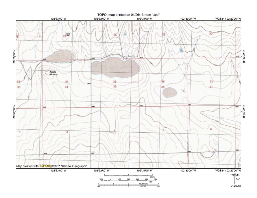
Figure 6: Detailed map of Eureka Creek-Willow Creek drainage divide area. United States Geological Survey map digitally presented using National Geographic Society TOPO software.
Figure 6 provides a detailed topographic map of the Eureka Creek-Willow Creek drainage divide area seen in less detail in figure 5. The map contour interval for figure 6 is 10 feet. A west-to-east oriented through valley in sections 34, 35, and 36 links the east oriented Willow Creek drainage basin with the south oriented Eureka Creek and Big Sandy Creek drainage basin. Willow Creek flows to the Smoky Hill River with water eventually reaching the Kansas, Missouri, and Mississippi Rivers. Big Sandy Creek flows to east oriented Arkansas River, which eventually flows directly to the Mississippi River. The drainage divide on the through valley floor has an elevation of between 4430 and 4440 feet. Elevations south of figure 6 rise to more than 4590 feet and elevations north of figure 6 rise even higher suggesting the through valley is at least 150 feet deep. Intermittent lakes seen in figure 6 are located in shallow basins defined by a single contour line, although the drainage divide in section 36, which separates two of the intermittent lakes is defined by three contour lines on its west side and is a significant barrier that deserves an explanation. Without visiting the site I can only guess as to the drainage origin. South oriented stream valleys enter the through valley on either side of the through valley and my guess is south oriented flood flow entered the through valley on both sides of the drainage divide after headward erosion of the Eureka Creek valley (west of figure 6) had beheaded and reversed flood flow to the newly eroded Willow Creek valley to create the drainage divide. If so the south oriented flood flow entering the through valley flowed in an east direction east of the drainage divide and in a west direction west of drainage divide and eroded the through valley floor lower on both sides of the drainage divide. Gradients of the through valley on both sides of the drainage divide are low and floodwaters and/or subsequent drainage flowing into the through valley deposited debris that created minor dams responsible for creating the shallow intermittent lake basins. In any case the through valley is a water eroded valley and was probably eroded by east oriented flood flow moving to the actively eroding Willow Creek valley prior to headward erosion of the deeper south oriented Eureka Creek valley (west of figure 6), which was prior to headward erosion of the North Fork Smoky Hill River valley (north of figure 6), which beheaded flood flow to the Eureka Creek valley.
Eureka Creek-Ladder Creek drainage divide area

Figure 7: Eureka Creek-Ladder Creek drainage divide area. United States Geological Survey map digitally presented using National Geographic Society TOPO software.
Figure 7 illustrates a topographic map of the Eureka Creek-Ladder Creek drainage divide area south and west of figure 5 and there is an overlap area with figure 5. The map contour interval for figure 7 is 10 meters. Eureka Creek meanders in a south direction near the west edge of figure 7 and south of figure 7 joins south oriented Big Spring Creek just before joining Big Sandy Creek, which then flows in a south-southeast and south direction to join the east oriented Arkansas River, which eventually flows directly to the Mississippi River. Ladder Creek originates just south of Firstview and flows in a southeast direction to the east center edge of figure 7. East of figure 7 Ladder Creek flows in an east and then southeast direction before turning to flow in an east and then north direction to join the east oriented Smoky Hill River with water eventually reaching the Kansas, Missouri, and Mississippi Rivers. South Ladder Creek originates near the center of figure 7 and flows in a southeast and east direction to the east edge of figure 7 (south half). East of figure 7 South Ladder Creek flows in an east direction and eventually joins Ladder Creek. Ladder Creek headwaters originate on that low hill, which is almost 80 meters higher than the Eureka Creek valley floor to the west suggesting headward erosion of the deeper south oriented Eureka Creek valley beheaded southeast oriented flood flow moving to the southeast and east oriented Ladder Creek valley. The 10-meter contour interval and other details in figure 7 show no obvious through valley crossing the low hill on which Firstview is located so a look at a more detailed topographic map is need to test the southeast oriented flood flow hypothesis. Figure 8 provides a detailed topographic map of the low hill at Firstview to determine whether or not there is evidence southeast oriented flood flow once crossed that low hill.
Detailed map of Eureka Creek-Ladder Creek drainage divide area
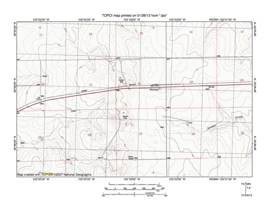
Figure 8: Detailed map of Eureka Creek-Ladder Creek drainage divide area. United States Geological Survey map digitally presented using National Geographic Society TOPO software.
Figure 8 provides a detailed topographic map of the Eureka Creek-Ladder Creek drainage divide seen in less detail figure 7. The map contour interval for figure 8 is 10 feet. Firstview is a railroad siding located near the center of figure 8. Ladder Creek originates near the east edge of section 27 (south of Firstview) and flows in an east direction to the east edge of figure 8 (south half). East of figure 8 Ladder Creek flows in a southeast, east, southeast, east, and north direction before finally joining the east oriented Smoky Hill River with water eventually reaching the Kansas, Missouri, and Mississippi Rivers. A northwest oriented intermittent stream originates in the northwest quadrant of section 22 and flows to the north edge of section 8 (west half). North of figure 8 that stream disappears as a surface stream, but it is headed toward south oriented Eureka Creek. West oriented intermittent streams flowing to the west edge of figure 8 in sections 20 and 29 also disappear as surface streams, but are headed toward south oriented Eureka Creek. While these streams do not actually reach Eureka Creek they would reach Eureka Creek if enough water was present and these streams are treated here as Eureka Creek tributaries. West of figure 8 Eureka Creek flows in a south direction and after joining south oriented Big Spring Creek joins south-southeast and south oriented Big Sandy Creek, which then flows to the east oriented Arkansas River, which eventually flows directly to the Mississippi River. The more detailed topographic map does show a through valley crossing the low hill at Firstview. The through valley links the northwest oriented Eureka Creek tributary valley and one of the west oriented Eureka Creek tributary valleys with the Ladder Creek headwaters valley. The through valley floor elevation is between 4560 and 4570 feet. Elevations in the northeast quadrant of section 22 to the north rise to more than 4590 feet and the Radio Tower in section 34 to the south is located on a hill rising to 4592 feet. These elevations suggest the through valley is at least 20 feet deep. This shallow through valley is a water-eroded valley and was eroded by east and southeast oriented flood flow moving to the actively eroding Ladder Creek valley prior to headward erosion of the deeper south oriented Eureka Creek valley to the west of figure 8. Headward erosion of the deeper south oriented Eureka Creek valley beheaded and reversed the east and southeast oriented flood flow routes to create the west and northwest oriented Eureka Creek tributary drainage routes seen in figure 8.
South Ladder Creek-Big Sandy Creek drainage divide area

Figure 9: South Ladder Creek-Big Sandy Creek drainage divide area. United States Geological Survey map digitally presented using National Geographic Society TOPO software.
Figure 9 illustrates a topographic map of the South Ladder Creek-Big Sandy Creek drainage divide area west of figure 7 and there is an overlap area with figure 7. The map contour interval for figure 9 is 10 meters. Firstview is located near the northeast corner of figure 9. Kit Carson is located along the west edge of figure 9. Big Sandy Creek (“Creek” in figure 9) flows in an east-southeast and south-southeast direction from the west edge of figure 9 (south of Kit Carson) to the south center edge of figure 9. South of figure 9 Big Sandy Creek flows in a south-southeast and south direction to join the east oriented Arkansas River, which eventually flows directly to the Mississippi River. The unlabeled southwest and south oriented stream flowing from the north center edge of figure 9 to join Big Sandy Creek is Eureka Creek. The unlabeled south oriented stream flowing from the north edge of figure 9 (west of center) to join Eureka Creek before they join Big Sandy Creek is Big Spring Creek. Ladder Creek originates just south of Firstview and flows in an east direction to the east edge of figure 9 (near northeast corner). East of figure 9 Ladder Creek flows in an east, southeast, east, southeast, east, and north direction to eventually join the east oriented Smoky Hill River with water eventually reaching the Kansas, Missouri, and Mississippi Rivers. South Ladder Creek originates further to the south of Firstview and flows in a southeast direction to the east center edge of figure 9. East of figure 9 South Ladder Creek flows in an east direction to eventually join Ladder Creek. South Ladder Creek originates at an elevation of approximately 1370 meters, which is significantly higher in elevation than the Eureka Creek and Big Sandy Creek valley floor elevations to the west. The hypothesis presented in this essay is the South Ladder Creek valley was eroded by southeast oriented flood flow, which crossed what is today the deeper south oriented Eureka Creek valley area to the northwest and which was beheaded by headward erosion of the deeper south oriented Eureka Creek valley. The 10-meter contour interval and lack of other detail hides evidence required to test this hypothesis so a look at the more detailed topographic map seen in figure 10 is needed.
Detailed map of Big Sandy Creek tributary-South Ladder Creek drainage divide area
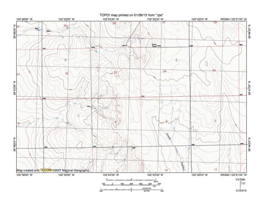
Figure 10: Detailed map of Big Sandy Creek tributary-South Ladder Creek drainage divide area. United States Geological Survey map digitally presented using National Geographic Society TOPO software.
Figure 10 provides a detailed topographic map of a Big Sandy Creek tributary-South Ladder Creek drainage divide area seen in less detail in figure 9. The map contour interval for figure 10 is 10 feet. South Ladder Creek originates in the south half of section 34 and flows in a south and south-southeast direction to the south edge of figure 10 (east half). South of figure 10 South Ladder Creek turns to flow in a southeast and then east direction and eventually joins Ladder Creek, which flows to the east oriented Smoky Hill River with water eventually reaching the Kansas, Missouri, and Mississippi Rivers. A northwest and west oriented intermittent stream originates in section 33 and flows to the west edge of figure 10 (near northwest corner). West of figure 10 that northwest and west oriented intermittent stream disappears as a surface stream, but it is flowing into the south oriented Eureka Creek-Big Sandy Creek valley and is treated here as a Big Sandy Creek tributary. Very shallow northwest-to-southeast oriented through valleys (defined by a single contour line on each side) link the northwest oriented intermittent Big Sandy Creek tributary valley with the south-southeast oriented South Ladder Creek headwaters valley. Evidence for the through valleys could be explained in other ways, but the alignment of the northwest oriented valley with the south-southeast oriented South Ladder Creek valley argues for a southeast oriented flood flow origin. In addition the flood flow origin is consistent with other evidence illustrated and discussed in this essay. Assuming the flood flow hypothesis is correct the South Ladder Creek valley was eroded by southeast oriented flood flow prior to headward erosion of the deeper south oriented Eureka Creek-Big Sandy Creek valley. Probably the Big Sandy Creek-Eureka Creek valley was eroding headward as the South Ladder Creek valley was eroding headward and headward erosion of the two valleys reached the region seen in figures 9 and 10 at about the same time. The Big Sandy Creek-Eureka Creek valley was deeper valley and was able to capture the southeast oriented flood flow, which had been flowing to the South Ladder Creek valley, with the result South Ladder Creek valley headward erosion ceased while Big Sandy Creek and Eureka Creek valley headward erosion continued.
Additional information and sources of maps studied
This essay has provided only a sample of the detailed topographic map evidence supporting the flood erosion interpretation. Many additional illustrations could be provided. Readers are encouraged to look at mosaics of detailed topographic maps to see the abundance of available data. Maps used in this study were created and published by the United States Geologic Survey and can be obtained directly from the United States Geological Survey and/or from dealers offering United States Geological Survey maps. Hard copy maps can also be observed at United States Geological Survey map depositories, which are located throughout the United States and elsewhere. Illustrations used here were created using National Geographic Society TOPO software and digital map data. TOPO software and map data can be obtained from the National Geographic Society and/or dealers offering National Geographic Society digital map data.

Leave a comment