
Abstract:
This essay uses topographic map evidence to interpret landform origins in the Republican River-Big Sandy Creek drainage divide area in Lincoln, Kit Carson, and Cheyenne Counties, Colorado. Big Sandy Creek is an east-northeast, north-northeast, southeast, and south oriented Arkansas River tributary located in eastern Colorado. North of the east-northeast and north-northeast oriented Big Sandy Creek segments are headwaters of north oriented tributaries to the east and northeast oriented South Platte River. North and east of the southeast oriented Big Sandy Creek segments are headwaters of east and northeast oriented Republican River tributaries. Cedar Point is just north of the elbow capture where north-northeast oriented Big Sandy Creek turns to flow in a southeast direction and is a triple drainage divide between north oriented South Platte River drainage, southeast and south oriented Big Sandy Creek (and Arkansas River) drainage, and northeast oriented Republican River drainage with the Republican River draining an upland surface higher in elevation than the adjacent Big Sandy Creek valley and the Beaver Creek valley (which drains to the South Platte River). The upland surface drained by Republican River tributaries appears to be capped by a resistant rock unit, which has limited the ability of Big Sandy Creek and Beaver Creek tributary valleys to erode headward into it. Through valleys west of Cedar Point link the north oriented Beaver Creek valley with the southeast and south oriented Big Sandy Creek valley. A deep through valley links the east and northeast oriented South Fork Republican River valley with the Big Sandy Creek valley. Several northeast-oriented Republican River tributaries originate as east oriented streams flowing along the rim of the Big Sandy Creek valley before turning in a northeast direction. These east oriented headwaters valleys are linked by shallow through valleys with headwaters of south oriented Big Sandy Creek tributary valleys. This evidence is interpreted in the context of immense floods, which were captured by headward erosion of three deep and competing valleys. Floodwaters were derived from the western margin of a thick North American ice sheet and flowed from western Canada to and across Colorado at a time when ice sheet related crustal warping was raising Colorado and when deep valleys were eroding headward into Colorado to capture the massive south oriented flood flow. Headward erosion of the Arkansas River valley captured the south oriented flood flow first and the Big Sandy Creek valley eroded headward from the newly eroded Arkansas River valley. Headward erosion of northeast oriented Republican River tributary valleys reached the Lincoln, Kit Carson, and Cheyenne County area at approximately the same time as headward erosion of the deeper Big Sandy Creek valley reached the region. At approximately the same time headward erosion of the deep east and northeast oriented South Platte River valley from western Nebraska entered northeast Colorado and beheaded south and southeast oriented flood flow channels first ending flood flow to the Republican River tributaries. When headward erosion of the South Platte River beheaded the south oriented flood flow channel on the present day north oriented Beaver Creek alignment floodwaters on the north end of the beheaded flood flow channel reversed flow direction to flow to the deeper South Platte River valley and to create the triple drainage divide at Cedar Point.
Preface
The following interpretation of detailed topographic map evidence is one of a series of essays describing similar evidence for all major drainage divides contained within the Missouri River drainage basin and for all major drainage divides with adjacent drainage basins. The research project is interpreting evidence in the context of a previously unexplored deep glacial erosion paradigm, which is fundamentally different from most commonly accepted North American glacial history interpretations. Project essays are listed on the sidebar category list under their appropriate Missouri River tributary drainage basin, Missouri River segment drainage basin (by state), and/or state in which the Missouri River drainage basin is located.
Introduction
The purpose of this essay is to use topographic map interpretation methods to explore the Republican River-Big Sandy Creek drainage divide area landform origins in Lincoln, Kit Carson, and Cheyenne Counties, Colorado. Map interpretation methods can be used to unravel many geomorphic events leading up to formation of present-day drainage routes and development of other landform features. While each detailed topographic map feature provides detailed evidence to be explained, the solution must be consistent with explanations for adjacent area map evidence as well as solutions to big picture map evidence puzzles. I invite readers to improve upon my solutions and/or to propose alternate solutions that better explain evidence and are also consistent with adjacent map area and big-picture evidence. Readers may do so either by making comments here or by writing and publishing their own essays and then by leaving a link to those essays in a comment here.
This essay is also exploring a new geomorphology paradigm in which erosional landforms are interpreted as evidence left by immense glacial melt water floods. Implied in that interpretation is the immense floods were derived from a thick North American ice sheet that created a deep “hole” in the North American continent and also melted fast. The previously unexplored paradigm being tested in this and other Missouri River drainage basin landform origins research project essays is a thick North American ice sheet, comparable in thickness to the Antarctic ice sheet, occupied the North American region usually recognized to have been glaciated, and through its weight and erosive actions created a deep North American “hole”. The southwestern rim of that deep “hole” is today preserved in the high Rocky Mountains. The ice sheet through its weight and deep erosion (and perhaps deposition along major south-oriented melt water flow routes) caused significant crustal warping and tectonic change, through its action of melting fast produced immense floods that flowed across the continent, and through its action of melting fast systematically opened up space in the ice sheet created “hole” so headward erosion of newly developed north-oriented drainage systems captured immense south-oriented melt water floods and diverted immense melt water floods north into space the ice sheet had once occupied.
If this previously unexplored paradigm is correct the geographic region explored by this essay should contain evidence of immense floods that were captured by headward erosion of new valley systems so as to cause the floods to flow in a different direction. Ability of this previously unexplored paradigm to explain Republican River-Big Sandy Creek drainage divide area landform evidence in Lincoln, Kit Carson, and Cheyenne Counties, Colorado will be regarded as evidence supporting the “thick ice sheet that melted fast” paradigm.
Republican River-Big Sandy Creek drainage divide area location map
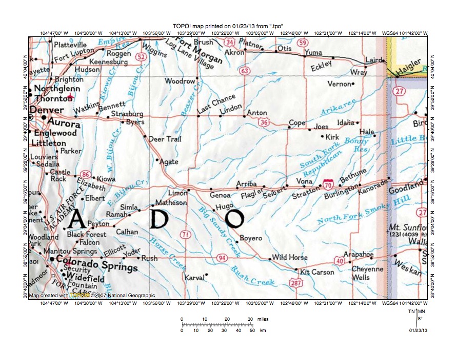
Figure 1: Republican River-Big Sandy Creek drainage divide area location map (select and click on maps to enlarge). National Geographic Society map digitally presented using National Geographic Society TOPO software.
Figure 1 provides a location map for the Republican River-Big Sandy Creek drainage divide area in Lincoln, Kit Carson, and Cheyenne Counties, Colorado and illustrates a region in eastern Colorado with a thin strip of northwest Kansas to the east and southwest Nebraska in the northeast corner of figure 1. Big Sandy Creek originates in the southwest quadrant of figure 1 and flows in an east-northeast, north-northeast direction through Ramah, Simla, and Matheson before turning to flow in a southeast direction near Limon, Hugo, Boyero, Wild Horse, and Kit Carson to reach the south edge of figure 1. South of figure 1 Big Sandy Creek turns to flow in a south direction to join the east oriented Arkansas River with water eventually reaching the Mississippi River. The South Fork Republican River originates east of Hugo and flows in a northeast direction to the east edge of figure 1 (north half). East of figure 1 the South Fork Republican River enters Nebraska and joins the North Fork to form the east oriented Republican River, which flows in southern Nebraska before turning in a southeast direction to join the Smoky Hill River in Kansas and to form the east oriented Kansas River, which flows to the Missouri River with water eventually reaching the Mississippi River. The North Fork Smoky Hill River originates north of Kit Carson and flows in an east-northeast direction to the east edge of figure 1 (south of center). East of figure 1 the North Fork flows to the Smoky Hill River, which joins the Republican River to form the Kansas River. The Arikaree River originates north of Limon and flows in a northeast direction to Haigler, Nebraska and then turns in an east direction to join the east oriented Republican River. The South Platte River (not labeled in figure 1) flows in a north direction from Denver to Platteville and north of figure 1 turns to flow in a southeast, east, and northeast direction to enter western Nebraska with water flowing to the Nebraska Platte River, the Missouri River, and the Mississippi River. North oriented streams flowing to the north edge of the west half figure 1 including Kiowa Creek, Bijou Creek, and Beaver Creek are tributaries to the southeast and east oriented South Platte River segments north of figure 1. The Republican River-Big Sandy Creek drainage divide area investigated in this essay includes the drainage divides between Beaver Creek and Big Sandy Creek, between the Arikaree River and Big Sandy Creek, and between the South Fork Republican River and Big Sandy Creek and focuses on the Big Sandy Creek segment between Limon and Boyero.
Drainage routes in Colorado and adjacent states developed during immense melt water floods from the western margin of a thick North American ice sheet. Floodwaters flowed from western Canada to and across Colorado as deep valleys eroded headward into Colorado from both the east and the west. Eastern Colorado drainage routes developed as deep east oriented valleys eroded headward into Colorado from what at that time were the developing Mississippi and Missouri River drainage systems. In very simplistic terms headward erosion of the Arkansas River valley (south of figure 1) first captured the south oriented flood flow and the Big Sandy Creek valley eroded headward along and across south and southeast oriented flood flow channels from the newly eroded east oriented Arkansas River valley. At the same time headward erosion of the Smoky Hill River valley and its tributary North Fork Smoky Hill River valley beheaded south and southeast oriented flood flow to the newly eroded Arkansas River valley and its actively eroding tributary valleys. Headward erosion of the Republican River valley and its northeast oriented South Fork Republican River tributary valley then captured flood flow moving to the newly eroded North Fork Smoky Hill River valley and headward erosion of the northeast oriented Arikaree River valley captured south and southeast oriented flood flow moving to the newly eroded South Fork Republican River valley. Headward erosion of the deep southeast, east, and northeast oriented South Platte River valley from western Nebraska into northeast Colorado (north of figure 1) then beheaded south and southeast oriented flood flow channels to the newly eroded Arikaree River and Big Sandy Creek valley. Floodwaters on north and northwest ends of the beheaded flood flow channels reversed flow direction to create north and northwest oriented South Platte River tributary drainage routes and the north oriented South Platte River route seen north of Denver in figure 1. Complicating this simplistic description was ice sheet related crustal warping, which was occurring as floodwaters flowed across the region and the fact that floodwaters flowed in different directions at different times. Generally directions of present day streams reflect the final direction of flood flow in that region.
Detailed location map for Republican River-Big Sandy Creek drainage divide area

Figure 2: Detailed location map Republican River-Big Sandy Creek drainage divide area. United States Geological Survey map digitally presented using National Geographic Society TOPO software.
Figure 2 provides a detailed location map for the Republican River-Big Sandy Creek drainage divide area in Lincoln, Kit Carson, and Cheyenne Counties, Colorado. County lines are shown and Lincoln, Kit Carson, and Cheyenne Counties are labeled. Big Sandy Creek flows in a southeast direction from the west edge of figure 2 (north half-near River Bend) to the south edge of figure 2 (east of center-near Wild Horse). South of figure 2 Big Sandy Creek turns to flow in a south direction to join the east oriented Arkansas River with water eventually reaching the Mississippi River. Beaver Creek is the north oriented stream originating near the northwest corner of figure 2. North of figure 2 Beaver Creek flows to the east and northeast oriented South Platte River with water eventually reaching the Platte, Missouri, and Mississippi Rivers. The Arikaree River is the unlabeled east-northeast oriented stream originating near the northwest corner of figure 2. North of figure 2 the Arikaree River flows into Nebraska to join the east and southeast oriented Republican River with water eventually reaching the Kansas, Missouri, and Mississippi Rivers. Hell Creek is a northeast oriented Arikaree River tributary originating near Genoa. The South Fork Republican River originates in the center region of figure 2 and flows in a northeast direction to the northeast corner of figure 2. North and east of figure 2 the South Fork flows into southern Nebraska to join the east and southeast oriented Republican River. South and southeast oriented streams seen in Cheyenne County flow to southeast and south oriented Big Sandy Creek while northeast and north-northeast oriented immediately to the north flow to the South Fork Republican River. Headward erosion of northeast oriented South Fork Republican River valley and its tributary valleys captured multiple southeast oriented flood flow channels flowing to the south oriented Big Sandy Creek valley and the east oriented Arkansas River valley. Subsequently headward erosion of the southeast, east, and northeast oriented South Platte River valley (north of figure 2) beheaded south and southeast oriented flood flow channels supplying floodwaters to the newly eroded northeast oriented Republican River tributary valleys. Floodwaters on north ends of beheaded flood flow channels reversed flow direction to flow in north directions to create north oriented South Platte River tributary drainage routes (not seen in figure 2, but seen in figure 1).
Beaver Creek-Big Sandy Creek drainage divide area
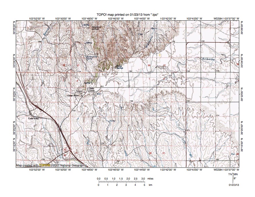
Figure 3: Beaver Creek-Big Sandy Creek drainage divide area. United States Geological Survey map digitally presented using National Geographic Society TOPO software.
Figure 3 provides a topographic map of Beaver Creek-Big Sandy Creek drainage divide area. The map contour interval for figure 3 is 10 meters. Cedar Point is a railroad siding located near the west edge of the southwest quadrant of figure 3. The south-southeast oriented stream originating near Cedar Point flows to north-northeast and east-southeast oriented Big Sandy Creek, which can just barely be seen along the south edge of the southwest quadrant of figure 3. South of figure 3 Big Sandy Creek flows in a southeast and eventually a south direction to join the east oriented Arkansas River with water eventually reaching the Mississippi River. The north and north-northeast oriented stream originating near Cedar Point and flowing to the north edge of figure 3 (west half) is Beaver Creek. North of figure 3 Beaver Creek flows in a northeast and north direction to join the east and northeast oriented South Platte River with water eventually reaching the Platte, Missouri, and Mississippi Rivers. Cedar Point is also a landform located at the west end of an escarpment surrounded upland surface and is located east and slightly north of the Cedar Point railroad siding. The escarpment surrounded upland surface is drained by the east-northeast and east oriented Arikaree River, which flows to the east edge of figure 3 (north half). East of figure 3 the Arikaree River flows in a northeast direction with water eventually reaching the Republican, Kansas, Missouri, and Mississippi Rivers. The landform Cedar Point is a triple drainage divide with drainage to the north being to the South Platte River, drainage to the south being to Big Sandy Creek and the Arkansas River, and drainage to the east being to the Arikaree and Republican Rivers. The Big Sandy Creek valley to south was eroded into the higher-level escarpment surrounded surface and the north oriented Beaver Creek drainage basin to the northwest was also eroded into the higher-level surface. Deep erosion was probably accomplished by south oriented flood flow moving from the present day north oriented Beaver Creek alignment to the southeast oriented Big Sandy Creek alignment in the region west of the Cedar Point landform, although before that deeper flood flow channel was eroded the south oriented flood flow moved across the upland surface to erode the north side of the Big Sandy Creek valley. South oriented flood flow across the upland surface ended as headward erosion of the east oriented Arikaree River valley captured the flood flow and diverted floodwaters to the newly eroded Republican River valley (north and east of figure 3). Subsequently headward erosion of the southeast, east, and northeast oriented South Platte River valley north of figure 3 beheaded south oriented flood routes across the region seen in figure 3. Floodwaters on north ends of the beheaded flood flow routes reversed flow direction to create north oriented South Platte River tributary drainage routes. Flood flow routes were beheaded and reversed in sequence from east to west, which meant a newly reversed flood flow channel could capture yet to be beheaded floodwaters in flood flow channels further to the west. Such captured floodwaters eroded the north oriented Beaver Creek tributary valleys on the north side of the upland surface.
Detailed map of Beaver Creek-Big Sandy Creek drainage divide area

Figure 4: Detailed map of Beaver Creek-Big Sandy Creek drainage divide area. United States Geological Survey map digitally presented using National Geographic Society TOPO software.
Figure 4 provides a detailed topographic map of the Beaver Creek-Big Sandy Creek drainage divide area seen in less detail in figure 3. The map contour interval for figure 4 is 20 feet. Cedar Point the landform is located near the northeast corner of figure 4 and has an elevation of 5991 feet. The Cedar Point railroad siding is located in the southwest quadrant of section 15 and extends into the north margin of section 22 and at its highest point has an elevation of 5707 feet. The north oriented stream originating along the east edge of section 15 and flowing to the north edge of figure 4 is Beaver Creek, which north of figure 4 flows in a northeast and north direction to join the east and northeast oriented South Platte River with water eventually reaching the Platte, Missouri, and Mississippi Rivers. North-northwest oriented streams near the west margin of figure 4 flow to north oriented Bijou Creek, which also flows to the east and northeast oriented South Platte River. South oriented streams flowing to the south edge of figure 4 flow to north-northeast and southeast oriented Big Sandy Creek near its elbow of capture, which is located south of figure 4. From the elbow of capture Big Sandy Creek flows in a southeast and south direction to reach the east oriented Arkansas River with water eventually reaching the Mississippi River. The Cedar Point railroad siding is located on the floor of a through valley linking the north oriented Beaver Creek and Bijou Creek valleys with the north-northeast, southeast, and south oriented Big Sandy Creek valley. South and west of figure 4 elevations along the drainage rise to more than 6000 feet suggesting the through valley is almost 300 feet deep. This deep and broad through valley was eroded by south oriented flood flow, which was captured by headward erosion of the southeast oriented Big Sandy Creek valley. The north-northeast oriented Big Sandy Creek valley segment to the south (see figure 1) was created by a reversal of flood flow on the north end of the beheaded south oriented flood flow channel. Streamlined landforms, such as seen in the east half of section 23, were eroded/deposited by the south-southeast oriented flood flow moving to the southeast oriented Big Sandy Creek valley. As seen in subsequent figures the southeast oriented Big Sandy Creek valley south of figure 4 may have eroded headward from the east and northeast oriented South Fork Republican River valley and was later captured by headward erosion of the deeper southeast and south oriented Big Sandy Creek valley, which was eroding headward from the east oriented Arkansas River valley.
Arikaree River-Big Sandy Creek drainage divide area
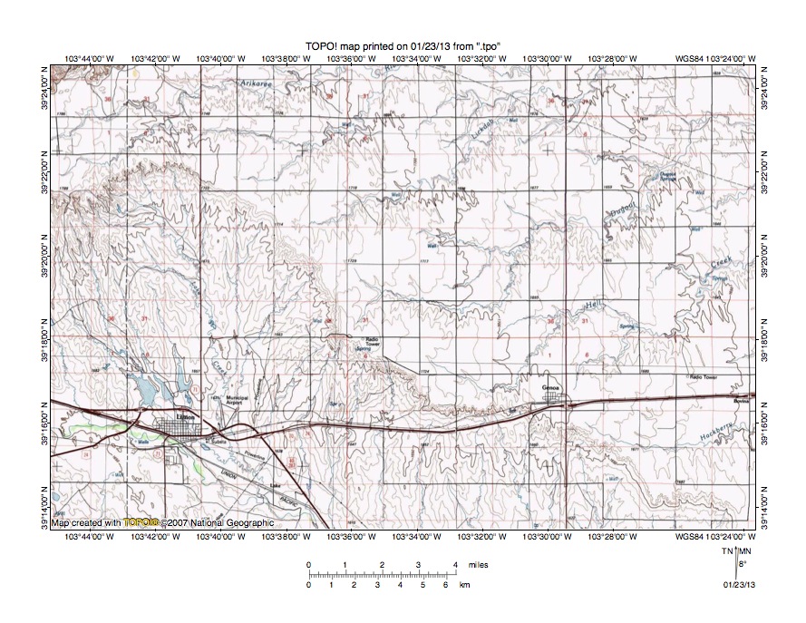
Figure 5: Arikaree River-Big Sandy Creek drainage divide area. United States Geological Survey map digitally presented using National Geographic Society TOPO software.
Figure 5 illustrates a reduced size topographic map of the Arikaree River-Big Sandy Creek drainage divide area east and south of figure 3 and includes an overlap area with figure 3. The map contour interval for figure 5 is 10 meters. Limon is the town near the southwest corner of figure 5. Big Sandy Creek flows in an east and southeast direction from the west edge of figure 5 through Limon to the south edge of figure 5. South of figure 5 Big Sandy Creek flows in a southeast and south direction to join the east oriented Arkansas River with water eventually reaching the Mississippi River. Lake Creek is the south oriented tributary joining Big Sandy Creek just east of Limon. The Arikaree River meanders in an east direction near the north edge of figure 5 from the west edge of figure 5 to the northeast quadrant of figure 5 and then turns to flow in a northeast direction. North of figure 5 the Arikaree River flows in a northeast direction to join the east and southeast oriented Republican River with water eventually reaching the Kansas, Missouri, and Mississippi Rivers. Lickdab, Dugout, and Hell Creek originate near the edge of the deep Big Sandy Creek valley and flow in east and then northeast directions to join the Arikaree River. Hackberry Creek (near south corner of figure 5) is an east and north-northeast oriented Hell Creek tributary. The upland surface on which the Arkaree River and its tributaries are flowing appears to be underlain by a resistant rock unit, which is gently dipping in an east direction. The deeper southeast oriented Big Sandy Creek valley eroded headward into the upland surface defined by this resistant rock unit to capture south oriented flood flow moving across the upland surface. The south oriented Lake Creek drainage basin for example was eroded by south oriented flood flow as a south oriented headcut into the newly eroded Big Sandy Creek valley. Apparently flood flow moving across the upland surface was not concentrated enough to erode deep channels across the upland surface. As headward erosion of the deep South Platte River valley north of figure 5 beheaded south oriented flood flow routes in sequence from east to west the south oriented flood flow crossing the upland surface ended from east to west. Final south oriented flood flow crossing the upland surface was captured in sequence by headward erosion of shallow east and northeast oriented Arikaree River tributary valleys and of the east oriented Arikaree River headwaters valley, which ended all south oriented flood flow into the Big Sandy Creek valley.
Detailed map of Hell Creek-Big Sandy Creek drainage divide area

Figure 6: Detailed map of Hell Creek-Big Sandy Creek drainage divide area. United States Geological Survey map digitally presented using National Geographic Society TOPO software.
Figure 6 provides a detailed topographic map of the Hell Creek-Big Sandy Creek drainage divide area seen in less detail in figure 5. The map contour interval for figure 6 is 10 feet. Hell Creek flows in an east-southeast, east, and north direction from near the northwest corner of figure 6 to the north center edge of figure 6. North of figure 6 Hell Creek flows in a northeast, east, and northeast direction to join the northeast oriented Arikaree River. The Arikaree River flows to the south and southeast oriented Republican River with water eventually reaching the Kansas, Missouri, and Mississippi Rivers. South oriented streams in the south half of figure 6 are tributaries to southeast and south oriented Big Sandy Creek. The edge of the Big Sandy Creek valley north wall appears to be rimmed by a 50-60 foot thick resistant rock unit. Shallow north-to-south oriented through valleys west of Genoa in sections 11 and 10 link the north oriented Hell Creek valley with south oriented Big Sandy Creek tributary valleys. The deepest through valley is defined by four contour lines on each side and is between 30 and 50 feet deep. Other through valleys are shallower with some defined by a single contour line on each side. While shallow the through valleys provide evidence south oriented flood flow once moved from the present day north oriented Hell Creek valley segment to the south oriented Big Sandy Creek tributary valleys, which were eroding headward into the resistant rock forming the edge of the Big Sandy Creek north wall. Headward erosion of the Hell Creek valley north of figure 6 beheaded a south oriented flood flow channel and floodwaters on the north end of the beheaded flood flow route reversed flow direction to create the north oriented Hell Creek drainage route segment, which then captured south oriented flood flow still moving on yet to be beheaded flood flow routes west of the newly reversed Hell Creek drainage route.
South Fork Republican River-Big Sandy Creek drainage divide area
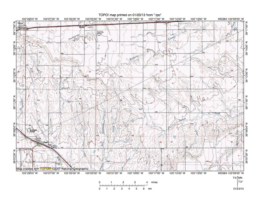
Figure 7: South Fork Republican River-Big Sandy Creek drainage divide area. United States Geological Survey map digitally presented using National Geographic Society TOPO software.
Figure 7 illustrates a reduced size topographic map of the South Fork Republican River-Big Sandy Creek drainage divide area south and east of figure 5 and there is an overlap area with figure 5. The map contour interval for figure 7 is 10 meters. Genoa is located near the northwest corner of figure 7 and Hugo is located near the southwest corner of figure 7. Big Sandy Creek flows in a southeast direction as it flows across the southwest corner of figure 7 through Hugo. South of figure 7 Big Sandy Creek flows in a southeast and south direction to join the east oriented Arkansas River with water eventually reaching the Mississippi River. The rim of the southeast oriented Big Sandy Creek valley extends in a southeast direction from Genoa to near the headwaters of east-northeast oriented Buffalo Creek, which flows to the north edge of figure 7 (east half). North and east of figure 7 Buffalo Creek flows in a northeast and then east direction to join the east-northeast oriented South Fork Republican River. Sevenmile Creek originates south of the Buffalo Creek headwaters and flows in a south direction to the south edge of figure 7 (west of center) and south of figure 7 joins Big Sandy Creek. Hackberry Creek originates near Genoa and flows for a short distance along the Big Sandy Creek valley rim before turning in a northeast direction to flow to the north edge of figure 7 (west half). North of figure 7 Hackberry Creek joins Hell Creek, which flows to the Arikaree River with water eventually reaching the Republican, Kansas, Missouri, and Mississippi Rivers. The South Fork Republican River originates in the southwest quadrant of figure 7 in a deep valley cut into the Big Sandy Creek valley northeast wall and flows in an east and east-northeast direction to the east edge of figure 7 (south of center). East of figure 7 the South Fork Republican River flows in an east-northeast and northeast direction into southern Nebraska to join the east and southeast oriented Republican River. Elevations where Buffalo Creek originates on the Big Sandy Creek valley rim are greater than 1650 meters. Elevations on the Big Sandy Creek northeast valley wall rim just south of figure 7 exceed 1640 meters. Between those two locations in the Sevenmile Creek-South Fork Republican River drainage divide area the Big Sandy Creek northeast valley wall rim elevation drops to between 1580 and 1590 meters, which suggests there is a 50-60 meter deep valley linking the southeast oriented Big Sandy Creek valley with the east and northeast oriented South Fork Republican River valley. South Fork Republican River headwaters and tributaries flow in southeast directions and near the Big Sandy Creek valley rim flow adjacent to and parallel to Sevenmile Creek headwaters suggesting both valleys eroded headward at the same time to capture southeast oriented flood flow. Headward erosion of the shallow Buffalo Creek valley captured the final southeast oriented flood flow moving to the actively eroding Sevenmile Creek and South Fork Republican River valleys, although large volumes of southeast oriented flood flow continued to erode the deeper Big Sandy Creek valley, which crosses the 1500 meter contour line just south of figure 7. The figure 7 evidence suggests at least some southeast oriented flood flow on the Big Sandy Creek at one time diverged from the Big Sandy Creek alignment to flow in an east and northeast direction along the present day South Fork Republican River alignment and that headward erosion of a deeper Big Sandy Creek valley beheaded the South Fork Republican River flood flow route.
Detailed map of South Fork Republican River-Big Sandy Creek drainage divide area

Figure 8: Detailed map of South Fork Republican River-Big Sandy Creek drainage divide area. United States Geological Survey map digitally presented using National Geographic Society TOPO software.
Figure 8 provides a detailed topographic map of the South Fork Republican River-Big Sandy Creek drainage divide seen in less detail figure 7. The map contour interval for figure 8 is 10 feet. Sevenmile Creek flows in a south and south-southwest direction from north edge of figure 8 (near northwest corner) to the west edge of figure 8 (near southwest corner). South of figure 8 Sevenmile Creek joins southeast and south oriented Big Sandy Creek, which flows to the east oriented Arkansas River with water eventually reaching the Mississippi River. Coon Creek originates near the center of figure 8 and flows in a south-southwest and south direction to the south edge of figure 8 (west half). South of figure 8 Coon Creek joins southeast and south oriented Big Sandy Creek. The South Fork Republican River flows in a south, east-southeast and northeast direction from the north edge of figure 8 (east half) to the northeast corner of figure 8. North and east of figure 8 the South Fork Republican River flows in a northeast direction to join the east oriented Republican River in Nebraska with water eventually reaching the Kansas, Missouri, and Mississippi Rivers. Two adjacent and parallel north-to-south oriented through valleys in section 1 link north oriented headwaters of a northeast oriented South Fork Republican River tributary with south and southwest oriented Coon Creek tributaries. The through valleys have floor elevations of between 5180 and 5190 feet. Just south of the southeast corner of figure 8 the drainage divide rises to 5385 feet and west and north of figure 8 the drainage divide elevation rises to more than 5500 feet. While not seen in figure 8 these nearby drainage divide elevations suggest the South Fork Republican River-Coon Creek through valleys seen in figure 8 are approximately 200 feet deep. The through valleys were eroded by south oriented flood flow moving from the present day southeast and south oriented South Fork Republican River valley to the south oriented Coon Creek valley and then to the southeast and south oriented Big Sandy Creek valley. Headward erosion of the deep northeast oriented South Fork Republican River valley captured the southeast and south oriented flood flow channel and diverted the floodwaters in a northeast direction and ended flood flow to the south oriented Coon Creek and Big Sandy Creek valley, although that was a final flood flow movement and earlier flood flow movements may have been somewhat different.
East Branch Spring Creek-Bellyache Creek drainage divide area

Figure 9: East Branch Spring Creek-Bellyache Creek drainage divide area. United States Geological Survey map digitally presented using National Geographic Society TOPO software.
Figure 9 illustrates a reduced size topographic map of the East Branch Spring Creek-Bellyache Creek drainage divide area south and east of figure 7 and there is an overlap area with figure 7. The map contour interval for figure 9 is 10 meters. Big Sandy Creek can just barely be seen flowing in a southeast direction across the southwest corner of figure 9. South of figure 9 Big Sandy Creek flows in a southeast and south direction to reach the east oriented Arkansas River with water eventually reaching the Mississippi River. South oriented Coon and Sevenmile Creeks are located a short distance west of figure 9 and the southeast, east, and northeast oriented South Fork Republican River valley is located just north of figure 9. The southwest-facing Big Sandy Creek valley wall rim extends from near the northwest corner of figure 9 to the Lincoln County eastern border. Northeast oriented South Fork Republican River tributaries originate near that Big Sandy Creek valley rim and flow to the north edge of figure 9 (west half) with Sand Creek being the tributary flowing to the north center edge. Spring Creek is an east and northeast oriented South Fork Republican River tributary originating near the northeast corner of figure 9. The East Branch Spring Creek originates near the center of figure 9 and flows in an east direction near the Kit Carson-Cheyenne County line before turning in a northeast direction to reach the east edge of figure 9. East and north of figure 9 the East Branch Spring Creek flows in a northeast and north-northeast direction to join Spring Creek, which then flows to the South Fork Republican River with water eventually reaching the Republican, Kansas, Missouri, and Mississippi Rivers. The northeast oriented South Fork Republican River tributaries originate near the edge of the deep southeast oriented Big Sandy Creek valley and sometimes flow in east directions along the Big Sandy Creek valley rim before turning in northeast directions. For example Bellyache Creek originates near the East Branch Spring Creek headwaters and flows in a south-southeast direction to south edge of figure 9 and south of figure 9 joins Big Sandy Creek. A close look at the East Branch Spring Creek-Big Sandy Creek drainage divide east of Bellyache Creek suggests headward erosion of the east oriented East Branch Spring Creek valley captured south and southeast oriented flood flow channels to the Big Sandy Creek valley. This evidence suggests northeast oriented South Fork Republican River tributary valleys were capturing diverging and converging south and southeast oriented flood flow channels flowing to the present day southeast and south oriented Big Sandy Creek valley, although at that time the deep Big Sandy Creek valley probably did not exist. At approximately the same time as the deep southeast oriented Big Sandy Creek valley eroded headward into the region the deep east and northeast oriented South Fork Republican River valley north of figure 9 was capturing south and southeast oriented flood flow crossing the present day South Fork Republican River-Big Sandy Creek drainage divide ending the south and southeast oriented flood flow to the newly eroded northeast oriented South Fork Republican River tributary valleys. The figure 9 evidence only makes sense if the deep east and northeast oriented South Fork Republican River valley and tributary valleys reached the figure 9 region at approximately the same time as the deep south and southeast oriented Big Sandy Creek valley eroded headward into the region and the two deep valleys were competing with each other to capture the south and southeast oriented flood flow.
Detailed map of East Branch Spring Creek-Bellyache Creek drainage divide area
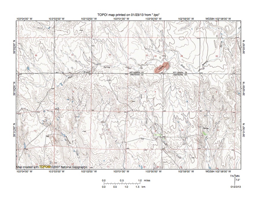
Figure 10: Detailed map of East Branch Spring Creek-Bellyache Creek drainage divide area. United States Geological Survey map digitally presented using National Geographic Society TOPO software.
Figure 10 provides a detailed topographic map of the East Branch Spring Creek-Bellyache Creek drainage divide area seen in less detail in figure 9. The map contour interval for figure 10 is 10 feet. The East Branch Spring Creek flows in an east direction from section 1 near the west center edge of figure 1 to section 35 in the northeast quadrant of figure 1 and then turns in a northeast direction to flow to the east edge of figure 1 (near northeast corner). North and east of figure 1 the East Branch Spring Creek flows in a northeast and north-northeast direction to join northeast and northeast oriented Spring Creek, which then joins the northeast oriented South Fork Republican River with water eventually reaching the Republican, Kansas, Missouri, and Mississippi Rivers. Tributaries to the east oriented East Branch Spring Creek are all oriented in southeast and south-southeast directions and there are no tributaries from the south. The east oriented East Branch Spring Creek segment is flowing along the rim of the Big Sandy Creek valley and south-southeast and south oriented streams originating just south of the east oriented East Branch Spring Creek valley segment are all tributaries to Big Sandy Creek. Bellyache Creek is the labeled south-southeast oriented Big Sandy Creek tributary in the southwest quadrant of figure 10. Pass Creek is the south and south-southeast oriented Big Sandy Creek tributary originating near the center of figure 10. Shallow through valleys cross the drainage divide between East Branch Spring Creek valley and the south and south-southeast oriented Bellyache Creek headwaters valleys. A close inspection of these through valleys reveals several are aligned with the valleys of south-southeast oriented East Branch Spring Creek tributaries. A similar, but somewhat less obvious situation can be seen at the Pass Creek headwaters area. This evidence suggests the East Branch Spring Creek valley eroded headward across south-southeast oriented flood flow channels leading to the deeper Big Sandy Creek valley, which could probably only occur as floodwaters were diminishing and ceasing to flow across the region. An end of south-southeast oriented flood flow would have occurred when the northeast oriented South Fork Republican River valley and its northeast oriented tributary valleys (north of figure 10) eroded headward across the region north of figure 10. The East Branch Spring Creek valley was probably able to capture the final flood flow movements because the Big Sandy Creek tributary valleys were not able to erode their valleys headward into the resistant cap rock rimming the Big Sandy Creek valley wall. Otherwise the south-southeast oriented Big Sandy Creek tributary valleys should have been able erode deep valleys headward across the present day east oriented East Branch Spring Creek valley.
Additional information and sources of maps studied
This essay has provided only a sample of the detailed topographic map evidence supporting the flood erosion interpretation. Many additional illustrations could be provided. Readers are encouraged to look at mosaics of detailed topographic maps to see the abundance of available data. Maps used in this study were created and published by the United States Geologic Survey and can be obtained directly from the United States Geological Survey and/or from dealers offering United States Geological Survey maps. Hard copy maps can also be observed at United States Geological Survey map depositories, which are located throughout the United States and elsewhere. Illustrations used here were created using National Geographic Society TOPO software and digital map data. TOPO software and map data can be obtained from the National Geographic Society and/or dealers offering National Geographic Society digital map data.

Leave a comment