
Abstract:
This essay uses topographic map evidence to interpret landform origins in the South Platte River-Big Sandy Creek drainage divide area in Elbert County, Colorado. Big Sandy Creek is an east-northeast, north-northeast, southeast, and south oriented Arkansas River tributary located in eastern Colorado. North of the east-northeast, north-northeast, and east-southeast oriented Big Sandy Creek segments are headwaters of north oriented Beaver Creek and East and West Bijou Creeks. East and West Bijou Creeks join to form Bijou Creek, which along with Beaver Creek flows in a north direction to join the southeast, east, and northeast oriented South Platte River in northeast Colorado with Beaver Creek located east of Bijou Creek. North-to-south oriented through valleys link the north oriented Beaver Creek, East Bijou Creek, and West Bijou Creek headwaters valleys with valleys of south oriented Big Sandy Creek tributaries. The through valleys provide evidence of diverging and converging south oriented flood flow channels that once crossed the region prior to headward erosion of the deep southeast, east, and northeast oriented South Platte River valley from western Nebraska into northeast Colorado. Floodwaters were derived from the western margin of a thick North American ice sheet and flowed from western Canada to and across Colorado as deep valleys eroded headward into Colorado. Headward erosion of the east oriented Arkansas River valley first captured the south oriented flood flow and the south oriented Big Sandy Creek valley then eroded headward along a south oriented flood flow channel before eroding headward across the south oriented flood flow channels to capture the south oriented flood flow. Headward erosion of the deep southeast, east, and northeast oriented South Platte River valley from western Nebraska next beheaded south oriented flood flow channels on the Colorado Piedmont. Floodwaters on north ends of beheaded flood flow channels reversed flow direction flow in north directions to the deeper east and northeast oriented South Platte River valley and to create north oriented South Platte River tributary drainage routes. The reversal of flood flow may have been aided by ice sheet related crustal warping that was raising the drainage divide area as floodwaters flowed across the region.
Preface
The following interpretation of detailed topographic map evidence is one of a series of essays describing similar evidence for all major drainage divides contained within the Missouri River drainage basin and for all major drainage divides with adjacent drainage basins. The research project is interpreting evidence in the context of a previously unexplored deep glacial erosion paradigm, which is fundamentally different from most commonly accepted North American glacial history interpretations. Project essays are listed on the sidebar category list under their appropriate Missouri River tributary drainage basin, Missouri River segment drainage basin (by state), and/or state in which the Missouri River drainage basin is located.
Introduction
The purpose of this essay is to use topographic map interpretation methods to explore the South Platte River-Big Sandy Creek drainage divide area landform origins in Elbert County, Colorado. Map interpretation methods can be used to unravel many geomorphic events leading up to formation of present-day drainage routes and development of other landform features. While each detailed topographic map feature provides detailed evidence to be explained, the solution must be consistent with explanations for adjacent area map evidence as well as solutions to big picture map evidence puzzles. I invite readers to improve upon my solutions and/or to propose alternate solutions that better explain evidence and are also consistent with adjacent map area and big-picture evidence. Readers may do so either by making comments here or by writing and publishing their own essays and then by leaving a link to those essays in a comment here.
This essay is also exploring a new geomorphology paradigm in which erosional landforms are interpreted as evidence left by immense glacial melt water floods. Implied in that interpretation is the immense floods were derived from a thick North American ice sheet that created a deep “hole” in the North American continent and also melted fast. The previously unexplored paradigm being tested in this and other Missouri River drainage basin landform origins research project essays is a thick North American ice sheet, comparable in thickness to the Antarctic ice sheet, occupied the North American region usually recognized to have been glaciated, and through its weight and erosive actions created a deep North American “hole”. The southwestern rim of that deep “hole” is today preserved in the high Rocky Mountains. The ice sheet through its weight and deep erosion (and perhaps deposition along major south-oriented melt water flow routes) caused significant crustal warping and tectonic change, through its action of melting fast produced immense floods that flowed across the continent, and through its action of melting fast systematically opened up space in the ice sheet created “hole” so headward erosion of newly developed north-oriented drainage systems captured immense south-oriented melt water floods and diverted immense melt water floods north into space the ice sheet had once occupied.
If this previously unexplored paradigm is correct the geographic region explored by this essay should contain evidence of immense floods that were captured by headward erosion of new valley systems so as to cause the floods to flow in a different direction. Ability of this previously unexplored paradigm to explain South Platte River-Big Sandy Creek drainage divide area landform evidence in Elbert County, Colorado will be regarded as evidence supporting the “thick ice sheet that melted fast” paradigm.
South Platte River-Big Sandy Creek drainage divide area location map
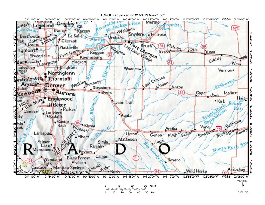
Figure 1: South Platte River-Big Sandy Creek drainage divide area location map (select and click on maps to enlarge). National Geographic Society map digitally presented using National Geographic Society TOPO software.
Figure 1 provides a location map for the South Platte River-Big Sandy Creek drainage divide area in Elbert County, Colorado and illustrates a region in eastern Colorado. The north-to-south oriented Colorado eastern border is located just east of the east edge of figure 1. Denver is located in the west center area of figure 1 and the Colorado Front Range is located west of Denver. The Colorado Piedmont is east of the Front Range. The South Platte River flows in a north-northeast direction from near the southwest corner of figure 1 to Denver and then to near the north edge of figure 1 (near Greeley) where it turns to flow in a southeast and east direction to Fort Morgan before flowing in a northeast direction to the north edge of figure 1 (east of center). North of figure 1 the South Platte River flows in a northeast and east direction into western Nebraska with water eventually reaching the Missouri and Mississippi Rivers. On the Colorado Piedmont several north oriented streams, including Kiowa Creek, Bijou Creek (and its East Bijou Creek and West Bijou Creek tributaries), and Beaver Creek, flow to the southeast, east, and northeast oriented South Platte River (near Fort Morgan). South of the East Bijou Creek and Beaver Creek headwaters is Big Sandy Creek, which originates near Peyton and which then flows in a northeast direction to near Limon before turning in a southeast direction to flow to the south edge of figure 1 (east of center). South of figure 1 Big Sandy Creek turns to flow in a south direction to reach the east oriented Arkansas River, which eventually reaches the Mississippi River. Headwaters of the east-northeast oriented North Fork Smoky Hill River can be seen near the southeast corner of figure 1. Northeast oriented headwaters of the South Fork Republican River flow to the east center edge of figure 1 and the northeast oriented Arikaree River flows to the east edge of figure 1 (north of center). East of figure 1 the Arikaree River joins the Republican River and the Republican River and Smoky Hill Rivers join to form the Kansas River with water eventually reaching the Missouri and Mississippi Rivers.The South Platte River-Big Sandy Creek drainage divide area investigated in this essay is located north of the Big Sandy Creek headwaters segment west of Limon, south and east of the northeast oriented East Bijou Creek headwaters segment, and south of the north oriented Beaver Creek headwaters.
South Platte River and Arkansas River drainage routes and their tributary drainage routes developed during immense melt water floods from the western margin of a thick North American ice sheet. Floodwaters flowed from western Canada to and across Colorado at a time when ice sheet related crustal warping was beginning to raise Colorado and when Colorado, Wyoming, and Montana mountain ranges were beginning to emerge. Floodwaters initially flowed in south directions on the present day Colorado Piedmont, although flood flow directions changed as deep valleys eroded headward into the region. First the south oriented floodwaters were captured by headward erosion of the east oriented Arkansas River valley (south of figure 1) and south oriented tributary valleys eroded headward from the newly eroded Arkansas River valley. As the south oriented Big Sandy Creek valley was eroding headward along south oriented flood flow channels headward erosion of east oriented valleys from the developing Missouri River drainage system eroded headward into the region with headward erosion of the Smoky Hill River valley beheading flood flow routes to the newly eroded Arkansas River valley, headward erosion of the South Fork Republican River valley beheading flood flow routes to the newly eroded North Fork Smoky Hill River valley, and headward erosion of the Arikaree River valley beheading south and southeast oriented flood flow to the newly eroded South Fork Republican River valley. At about the same time headward erosion of the south oriented Big Sandy Creek valley caused south oriented floodwaters to flow in southeast directions toward the deeper Big Sandy Creek valley. The Big Sandy Creek valley then eroded headward along a southeast oriented flood flow channel before turning to erode headward across the southeast oriented flood flow routes flowing to the newly eroded and deeper south oriented Big Sandy Creek valley. Headward erosion of the deep southeast, east, and northeast oriented South Platte River valley from western Nebraska into northeast Colorado and across the Colorado Piedmont next captured the south oriented flood flow and beheaded the south oriented flood flow channels on the Colorado Piedmont. Floodwaters on north ends of the beheaded flood flow channels reversed flow direction to flow in north directions to the deeper southeast, east, and northeast oriented South Platte River valley and to create north oriented South Platte River tributary drainage routes and the north-northeast oriented South Platte River drainage route through Denver.
Detailed location map for South Platte River-Big Sandy Creek drainage divide area
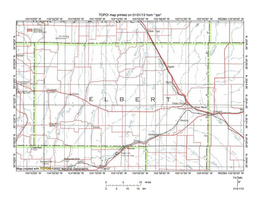
Figure 2: Detailed location map for South Platte River-Big Sandy Creek drainage divide area. United States Geological Survey map digitally presented using National Geographic Society TOPO software.
Figure 2 provides a detailed location map for the South Platte River-Big Sandy Creek drainage divide area in Elbert County, Colorado. County lines are shown and Elbert County is labeled. The north-northeast and north oriented stream in western Elbert County flowing from near the south edge of figure to the towns of Elbert and Kiowa and then to the north edge of figure 2 is Kiowa Creek, which north of figure 2 flows to the southeast, east, and northeast oriented South Platte River. Rattlesnake Butte is a labeled high point near the south edge of the southwest quadrant of figure 2. West Bijou Creek originates near Rattlesnake Butte and flows in a north-northeast and north direction to near the town of Fondis and then to the north center edge of figure 2. East Bijou Creek originates near the south edge of Elbert County a short distance south and east of Fondis and flows in a northeast, east, and north direction to near Agate and then in a north-northwest direction to Deer Tail and the north center edge of figure 2. North of figure 2 East and West Bijou Creeks join to form north oriented Bijou Creek, which flows to the east and northeast oriented South Platte River. Beaver Creek (unlabeled in figure 2) originates north of Cedar Point (in eastern Elbert County) and flows in a north and north-northeast direction to the north edge of figure 2 (east half). North of figure 2 Beaver Creek flows to the east and northeast oriented South Platte River. Other north oriented streams flowing to the north edge of figure 2 are tributaries to Kiowa Creek, Bijou Creek, or Beaver Creek. Big Sandy Creek originates a short distance east of Rattlesnake Butte and flows in an east-northeast direction to Ramah, Simla, and Matheson and then in a north-northeast direction through Resolis to Cedar Point before turning in an east-southeast direction to flow to Limon and then turning in a southeast direction to flow to the east edge of figure 2 (south half). East and south of figure 2 Big Sandy Creek turns to flow in a south direction to join the east oriented Arkansas River. Southeast oriented streams near the southeast corner of figure 2 are tributaries to Big Sandy Creek. The unlabeled east-northeast and northeast oriented stream originating north of River Bend and flowing to the east edge of figure 2 (north half) is the headwaters of the Arikaree River, which east of figure 2 joins the Republican River. South oriented flood flow in the southeast quadrant of figure 2, which was moving to the newly eroded Arkansas River valley, was diverted in a southeast direction by headward erosion of the deep south oriented Big Sandy Creek valley, which then eroded headward along one of the southeast oriented flood flow routes. The Big Sandy Creek headwaters valley then eroded headward across the southeast flood flow routes to create the east-northeast and north-northeast oriented Big Sandy Creek headwaters drainage route.
Beaver Creek-Big Sandy Creek drainage divide area
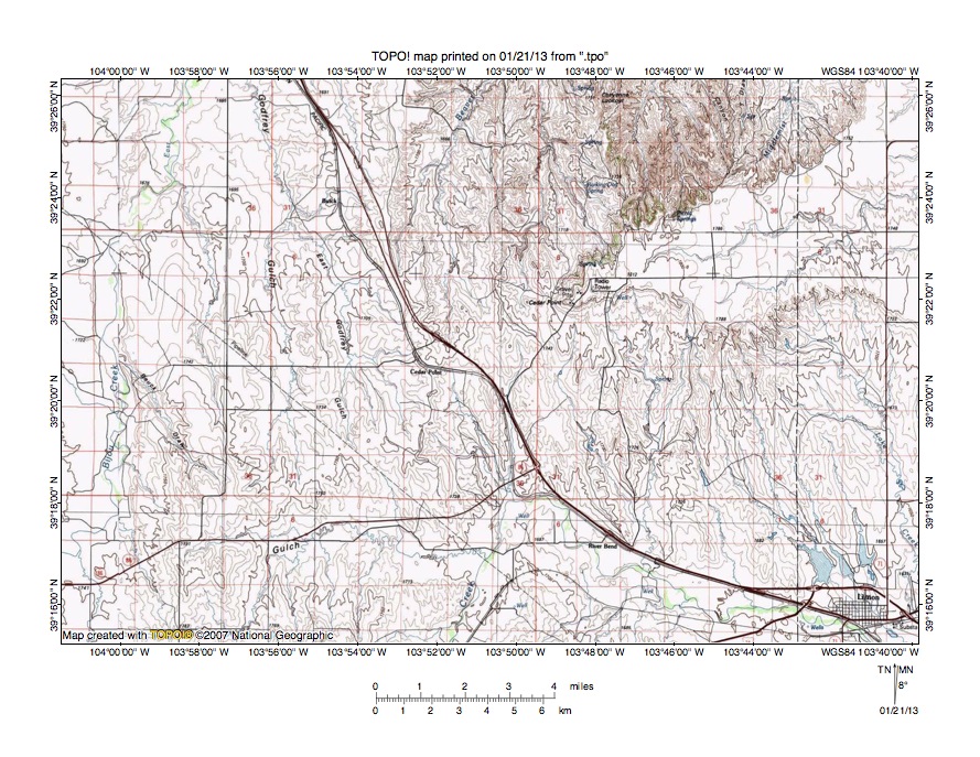
Figure 3: Beaver Creek-Big Sandy Creek drainage divide area. United States Geological Survey map digitally presented using National Geographic Society TOPO software.
Figure 3 provides a reduced size topographic map of Beaver Creek-Big Sandy Creek drainage divide area. The map contour interval for figure 3 is 10 meters. Limon is the town near the southeast corner of figure 3. Big Sandy Creek flows in a north-northeast direction from the south center edge of figure 3 and then makes an abrupt turn (north and west of River Bend) to flow in an east-southeast direction to near River Bend and then to Limon. South and east of figure 3 Big Sandy Creek flows in a southeast and south direction to join the east oriented Arkansas River. The north-northeast and east oriented “Gulch” flowing from the south edge of figure 3 (west half) to join Big Sandy Creek in the south center area of figure 3 is Willow Gulch. Cedar Point is a railroad siding name near the center of figure 3. Cedar Point is also the name of a landform east and slightly north of the railroad siding location and represents the western end of an escarpment-surrounded upland surface. Cedar Point (the landform) is a triple drainage divide and is drained to the north by South Platte River tributaries, to the east by a Republican River tributary, and to the south by Arkansas River tributaries. The east-northeast oriented stream originating on that high-level Cedar Point upland surface and flowing to the east edge of figure 3 (north half) is the Arikaree River, which east of figure 3 flows to the Republican River, which flows to the Kansas River, which in turn flows to the Missouri and Mississippi Rivers. The north and north-northeast oriented stream originating north of the Cedar Point railroad siding is Beaver Creek, which flows to the north center edge of figure 3. North of figure 3 Beaver Creek flows in a northeast and north direction to join the east and northeast oriented South Platte River. North oriented streams originating in the northeast quadrant of figure 3 are Beaver Creek tributaries. East Bijou Creek flows in a north and north-northeast direction from near the southwest corner of figure 3 to the north edge of figure 3. North of figure 3 East Bijou Creek joins north oriented West Bijou Creek to form north oriented Bijou Creek, which flows to the east and northeast oriented South Platte River. Godfrey Gulch is a north oriented East Bijou Creek tributary. Cedar Point (the landform) has an elevation greater than 1810 meters. West of Cedar Point elevations along the South Platte River-Arkansas River drainage divide decrease to between 1740 and 1750 meters at the Cedar Point railroad siding and then at two other locations before rising to more than 1800 meters near the southwest corner of figure 3. In other words the Cedar Point railroad siding is located in a through valley linking the north-northwest oriented East Godfrey Gulch valley and north oriented East Bijou Creek valley with the east-southeast, southeast, and south oriented Big Sandy Creek valley. The through valley is at least 60 meters deep and apparently had multiple channels. The through valley was eroded by south-southeast oriented flood flow moving from the present day north oriented Bijou Creek valley to the southeast and south oriented Big Sandy Creek valley. Headward erosion of the deep east and northeast oriented South Platte River valley north of figure 3 beheaded and reversed the south oriented flood flow channel to create the north oriented Bijou Creek drainage route and its tributary East Bijou Creek, Godfrey Gulch, and East Godfrey Gulch drainage routes.
Detailed map of Beaver Creek-Big Sandy Creek drainage divide area
Figure 4: Detailed map of Beaver Creek-Big Sandy Creek drainage divide area. United States Geological Survey map digitally presented using National Geographic Society TOPO software.
Figure 4 provides a detailed topographic map of the Beaver Creek-Big Sandy Creek drainage divide area seen in less detail in figure 3. The map contour interval for figure 4 is 20 feet. Cedar Point (the landform) is located near the northeast corner of figure 4. The Cedar Point railroad siding is located near the west center edge of figure 4. Beaver Creek originates along the border between sections 14 and 15 (near the Cedar Point railroad siding) and flows in a north direction to the north edge of figure 4 (west half). North of figure 4 Beaver Creek flows in a north, northeast, and north direction to eventually join the east and northeast oriented South Platte River. Other north oriented streams flowing to the north edge of figure 4 are tributaries to north, northeast, and north oriented Beaver Creek. South oriented streams flowing to the south edge of figure 4 are tributaries to east-southeast, southeast, and south oriented Big Sandy Creek, which flows to the east oriented Arkansas River. The west oriented stream at the Cedar Point railroad siding is a tributary to north-northwest oriented East Godfrey Gulch, which drains to north oriented Godfrey Gulch, when then drains to north oriented East Bijou Creek, which flows to north oriented Bijou Creek, which flows to the east and northeast oriented South Platte River. North-to-south oriented through valleys link the north oriented Beaver Creek valley and its north oriented tributary valleys with the south oriented Big Sandy Creek tributary valleys. The deepest through valley is located in the southwest corner of section 7 (near northeast corner of figure 4) and has an elevation of between 5680 and 5700 feet. Cedar Point in the northeast corner of figure 4 has an elevation of 5991 feet. Elevations near the south edge of section 12 to the west of the through valley rise to more than 5800 feet suggesting the through valley is at least 100 feet deep. A shallower north-to-south oriented through valley in the northeast corner area of section 14 links a north oriented Beaver Creek tributary valley with a south oriented Big Sandy Creek tributary valley and has an elevation of between 5700 and 5720 feet. Elevations along the drainage divide rise to at least 5800 feet on both sides of the through valley suggesting the through valley is at least 80 feet deep. South and west of figure 4 elevations along the South Platte River-Big Sandy Creek drainage divide rise to more than 5900 feet suggesting the through valleys seen in figure 4 are really approximately 200 feet deep and are really deeper channels on the floor of a broader north-to-south oriented through valley linking the north oriented Beaver Creek and East Bijou Creek valleys with the southeast and south oriented Big Sandy Creek valley. The through valleys were eroded by diverging and converging south oriented flood flow channels prior to headward erosion of the deep east and northeast oriented South Platte River valley north of figure 4, which beheaded and reversed the south oriented flood flow channels to create the north oriented Bijou Creek and Beaver Creek drainage routes and the South Platte River-Big Sandy Creek drainage divide.
East Bijou Creek-Willow Gulch drainage divide area
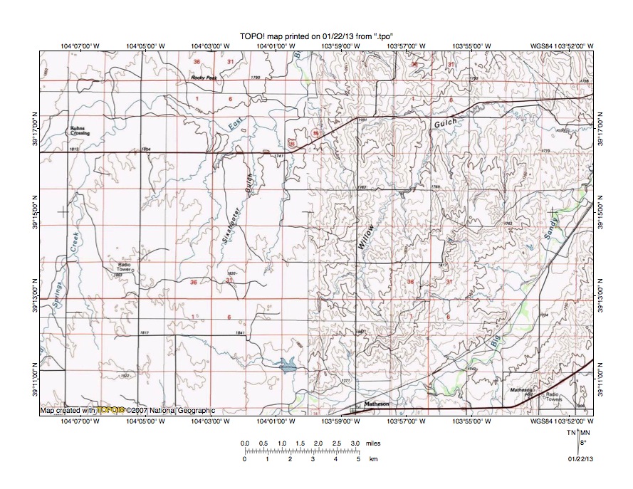
Figure 5: East Bijou Creek-Willow Gulch drainage divide area. United States Geological Survey map digitally presented using National Geographic Society TOPO software.
Figure 5 illustrates a topographic map of the East Bijou Creek-Willow Gulch drainage divide area south and west of figure 3 and includes an overlap area with figure 3. The map contour interval for figure 5 is 10 meters in the east half and is 50 meters in the west half. Big Sandy Creek flows in an east-northeast and north-northeast direction from the south center edge of figure 5 to the east edge of figure 5 (north of center). East of figure 5 Big Sandy Creek turns to flow in an east-southeast, southeast, and south direction to eventually reach the east oriented Arkansas River. Matheson is a town near the south edge of figure 5 (east of center). Willow Gulch originates north of Matheson and drains in a north-northeast and east direction to the east edge of figure 5 (north half) and joins Big Sandy Creek east of figure 5. East Bijou Creek meanders in an east direction from the west edge of figure 5 (north half) to Kuhns Crossing and to the north center area of figure 5 before turning to flow in north direction to the north center edge of figure 5. North of figure 5 East Bijou Creek flows in a north direction to join north oriented West Bijou Creek and to form north oriented Bijou Creek, which flows to the east and northeast oriented South Platte River. Reed Springs Creek is a north-northeast tributary flowing from the west edge of figure 5 (near southwest corner) to join East Bijou Creek east of Kuhns Crossing. Sixshooter Gulch is a north-northeast and north oriented East Bijou Creek tributary located between Reed Springs Creek and Willow Gulch. The 50-meter contour interval does not provide enough detail to show most shallow through valleys linking the north oriented East Bijou Creek tributary valleys with the Big Sandy Creek valley, although a through valley defined by one contour line on each side can be seen linking the north oriented Sixshooter Gulch valley with an east oriented Big Sandy Creek tributary valley. The through valley provides evidence that prior to the reversal of flood flow in the Bijou Creek drainage basin floodwaters flowed in a south direction to (or beyond) the Big Sandy Creek valley. Moving into the 10-meter contour line area north of the center of figure 5 a north oriented tributary to the north oriented East Bijou Creek segment is linked by a through valley with the north-northeast oriented Willow Creek headwaters valley. A road intersection on the through valley floor has an elevation of 1783 meters, Elevations south and north of the through valley rise to more than 1800 meters suggesting the through valley is at least 17 meters deep. The through valley was eroded by south oriented flood flow moving from the present day north oriented East Bijou Creek alignment to the present day north-northeast oriented Willow Gulch alignment and then to or across the Big Sandy Creek alignment. Figure 6 provides a detailed map of the Willow Gulch-Big Sandy Creek drainage divide area to see if there is evidence of north-to-south oriented through valleys crossing that drainage divide.
Detailed map of Willow Gulch-Big Sandy Creek drainage divide area
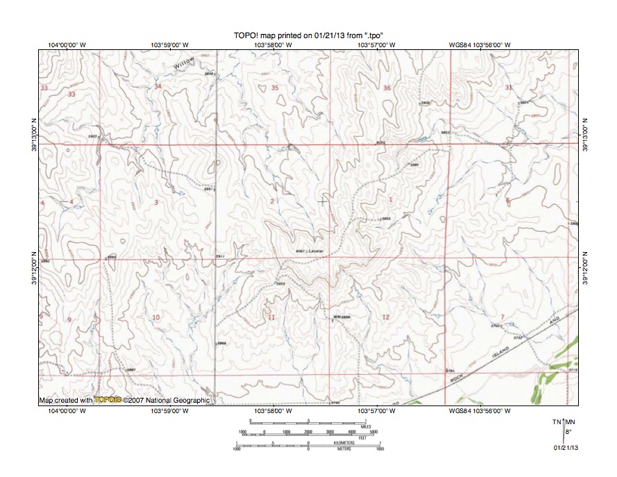
Figure 6: Detailed map of Willow Gulch-Big Sandy Creek drainage divide area. United States Geological Survey map digitally presented using National Geographic Society TOPO software.
Figure 6 provides a detailed topographic map of the Willow Gulch-Big Sandy Creek drainage divide area seen in less detail in figure 5. The map contour interval for figure 6 is 20 feet. Big Sandy Creek flows in a northeast direction across the southeast corner of figure 6. East of figure 6 Big Sandy Creek flows in a north-northeast direction before turning in an east-southeast, southeast, and south direction to flow to the east oriented Arkansas River. Willow Gulch drains in an east, north, east, north, and east direction from section 4 to sections 3, 34, and 35 before draining in a north direction to the north edge of figure 6 and then in a north-northeast and east direction to join Big Sandy Creek. In section 3 a north-to-south oriented through valley links a north oriented Willow Gulch tributary valley with a south oriented Big Sandy Creek tributary valley. The through valley floor elevation is between 5930 and 5940 feet. Elevations in the southeast corner of section 2 rise to 6067 feet and elevations in the southeast corner of section 4 elevations rise to more than 6020 feet and west of figure 6 elevations along the drainage divide rise to 6050 feet. These elevations suggest the through valley is approximately 100 feet deep. The through valley was eroded by south oriented flood flow moving from the present day north oriented Willow Gulch valley to the south oriented Big Sandy Creek tributary valley. Headward erosion of the east oriented Willow Gulch valley north of figure 6 beheaded and reversed the south oriented flood flow to create the north-northeast oriented Willow Gulch headwaters drainage route. As seen in figure 5 the south oriented flood flow was moving from the present day north oriented East Bijou Creek alignment to the present day north oriented Willow Gulch alignment, which means headward erosion of the east oriented Willow Gulch valley beheaded and reversed south oriented flood flow. Deeper through valleys north of figure 6 link the north oriented East Bijou Creek valley with the east oriented Willow Gulch valley. South oriented flood flow on the East Bijou Creek alignment was subsequently beheaded and reversed to create the north oriented East Bijou Creek drainage route.
Reed Springs Creek-Big Sandy Creek drainage divide area
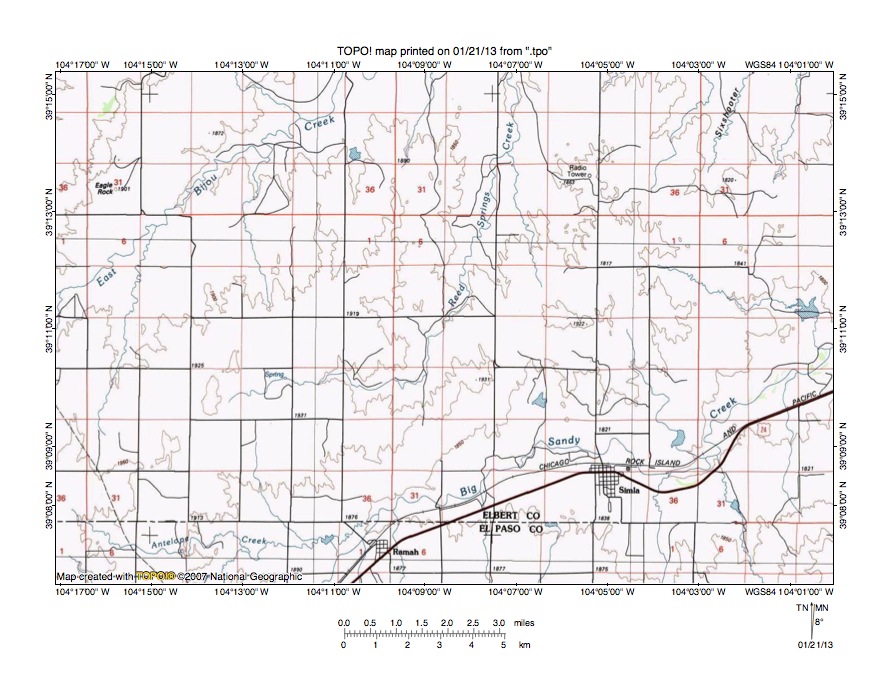
Figure 7: Reed Springs Creek-Big Sandy Creek drainage divide area. United States Geological Survey map digitally presented using National Geographic Society TOPO software.
Figure 7 illustrates the Reed Springs Creek-Big Sandy Creek drainage divide area south and west of figure 5 and there is an overlap area with figure 5. The map contour interval for figure 7 is 50 meters. East Bijou Creek flows in a northeast direction from the west center edge of figure 7 to the north edge of figure 7 (west of center). North of figure 7 East Bijou Creek turns to flow in a north direction to join West Bijou Creek and to form north oriented Bijou Creek, which flows to the east and northeast oriented South Platte River. Reed Springs Creek originates in the southwest quadrant of figure 7 and flows in an east direction before turning to flow in a north-northeast direction to the north edge of figure 7 (slightly east of center). North of figure 7 Reed Springs Creek joins East Bijou Creek. Big Sandy Creek flows in an east-northeast direction from the south edge of figure 7 (west of center) to the towns of Ramah and Simla and then to the east edge of figure 7. East of figure 7 Big Sandy Creek flows in a north-northeast, east-southeast, southeast, and south direction to join the east oriented Arkansas River. Antelope Creek is an east oriented tributary originating near the southwest corner of figure 7 and joins Big Sandy Creek near Ramah. The 50-meter contour interval hides most of the shallow through valleys linking the north oriented East Bijou Creek tributary valleys with the Big Sandy Creek valley, but north of Simla a through valley defined by one contour line on each side links the north oriented Reed Spring Creek valley with the Big Sandy Creek valley. Further west a through valley links an unnamed north oriented East Bijou Creek tributary valley with the east oriented Antelope Creek valley. Diverging and converging south oriented flood flow channels eroded these shallow through valleys prior to the reversal of flood flow that created the north oriented East Bijou Creek drainage system. Figure 8 provides a detailed topographic map of the Reed Springs Creek-Big Sandy Creek drainage divide area seen north of Simla in figure 7.
Detailed map of Reed Springs Creek-Big Sandy Creek drainage divide area
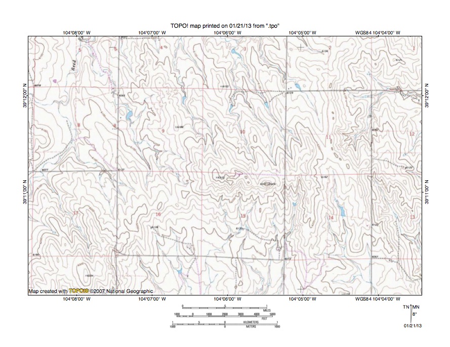
Figure 8: Detailed map of Reed Springs Creek-Big Sandy Creek drainage divide area. United States Geological Survey map digitally presented using National Geographic Society TOPO software.
Figure 8 provides a detailed topographic map of the Reed Springs Creek-Big Sandy Creek drainage divide seen in less detail figure 7. The map contour interval for figure 8 is 20 feet. Reed Springs Creek flows in a north-northeast and north direction from the west center edge of figure 8 to the north edge of figure 8 (west half). North of figure 8 Reed Spring Creek flows in a north-northeast direction to join northeast and north oriented East Bijou Creek, which then joins north oriented West Bijou Creek to form north oriented Bijou Creek, which flows to the east and northeast oriented South Platte River. Unnamed north-northwest oriented streams flowing to the north edge of figure 8 are tributaries to Reed Springs Creek. South oriented streams flowing to the south edge of figure 8 are tributaries to east-northeast, north-northeast, east-southeast, southeast, and south oriented Big Sandy Creek, which flows to the east oriented Arkansas River. The east oriented stream originating near the east edge of the northeast quadrant of figure 8 is an east and east-southeast oriented tributary to Big Sandy Creek. A north-to-south oriented through valley in section 16 links north-northwest oriented Reed Springs Creek tributary valleys with south oriented Big Sandy Creek tributary valleys. The through valley floor elevation is between 6160 and 6180 feet. Elevations in the northwest corner of section 15 to the east of the through valley rise to 6310 feet and elevations in section 20 (near southwest corner of figure 8) rise to 6334 feet suggesting the through valley is at least 130 feet deep. The through valley was eroded by south oriented flood flow moving to the Big Sandy Creek valley prior to the reversal of flood flow that created the north oriented Reed Springs Creek drainage route. The reversal of flood flow probably occurred about the same time as the reversal of flood flow that created the north oriented Bijou Creek drainage route although the two flood flow reversals probably were not simultaneous.
West Bijou Creek-Big Sandy Creek drainage divide area
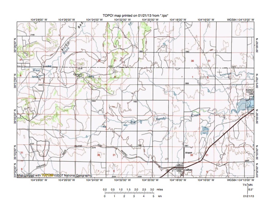
Figure 9: West Bijou Creek-Big Sandy Creek drainage divide area. United States Geological Survey map digitally presented using National Geographic Society TOPO software.
Figure 9 illustrates the West Bijou Creek-Big Sandy Creek drainage divide area south and west of figure 7 and there is an overlap area with figure 7. The map contour interval for figure 9 is 50 meters. The west-to-east dashed line extending across the north half of figure 9 is the Elbert County-El Paso County line with El Paso County south of Elbert County. West Bijou Creek flows in an east and north-northeast direction across the northwest corner of figure 9. North of figure 9 West Bijou Creek joins East Bijou Creek to form north oriented Bijou Creek, which flows to the east and northeast oriented South Platte River. Big Sandy Creek originates in the southwest quadrant of figure 9 and flows in an east and east-northeast direction to the east edge of figure 9 (slightly south of center). East of figure 9 Big Sandy Creek flows in an east-northeast, north-northeast, east-southeast, southeast, and south direction to join the east oriented Arkansas River. Fremont Fort is a labeled high point located in the northwest quadrant of figure 9. A northwest-to-southeast oriented through valley south of Fremont Fort links the east and north-northeast oriented West Bijou Creek valley with the a southeast oriented Big Sandy Creek tributary valley. The through valley floor elevation is between 2050 and 2100 meters. The butte at Fremont Fort rises to 2178 meters and elevations on the southwest side of the through valley rise to more than 2200 meters suggesting the through valley is at least 78 meters deep. The through valley was eroded by south and southeast oriented flood flow moving to the Big Sandy Creek valley prior to the reversal of flood flow that created the north-northeast oriented West Bijou Creek drainage route. At least some of the south and southeast floodwaters flowed in a south direction on the present day north oriented Kiowa Creek alignment, which is located north of the east oriented West Bijou Creek headwaters (west of figure 9). South oriented flood flow on the Bijou Creek alignment was beheaded and reversed by headward erosion of the east and northeast oriented South Platte River valley before flood flow on the Kiowa Creek alignment was beheaded and reversed, which means south oriented flood flow on the Kiowa Creek alignment was captured by reversed flood flow on the West Bijou Creek alignment and flowed in an east direction along the present day east oriented West Bijou Creek alignment to reach the newly reversed West Bijou Creek drainage route. This captured flood flow eroded the deep east and north-northeast oriented West Bijou Creek valley seen in figure 9.
Detailed map of West Bijou Creek-Big Sandy Creek drainage divide area
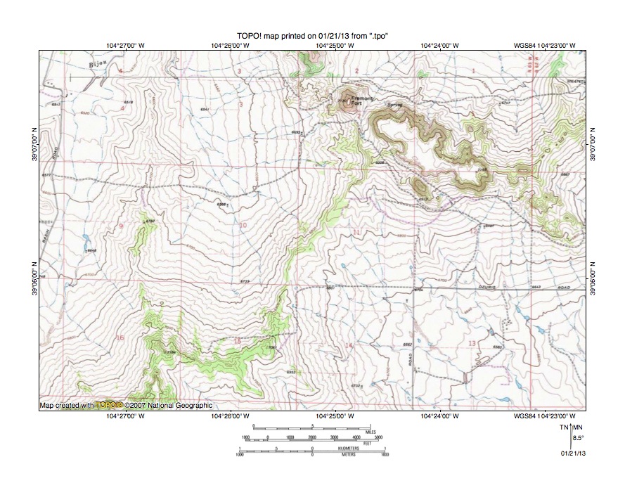
Figure 10: Detailed map of West Bijou Creek-Big Sandy Creek drainage divide area. United States Geological Survey map digitally presented using National Geographic Society TOPO software.
Figure 10 provides a detailed topographic map of the West Bijou Creek-Big Sandy Creek drainage divide area seen in less detail in figure 9. The map contour interval for figure 10 is 20 feet. West Bijou Creek flows in a northeast direction across the northwest corner of figure 10. North of figure 10 West Bijou Creek joins East Bijou Creek to form north oriented Bijou Creek, which flows to the east and northeast South Platte River. Southeast oriented streams in the southeast quadrant of figure 10 flow to east-northeast, north-northeast, east-southeast, southeast, and south oriented Big Sandy Creek, which flows to the east oriented Arkansas River. Fremont Fort is an isolated butte located near the north edge of figure 10 and reaches an elevation of 7130 feet. The larger butte to the southeast of Fremont Fort reaches an elevation greater than 7160 feet. Elevations along the West Bijou Creek-Big Sandy Creek drainage divide near the south edge of figure 10 exceed 7200 feet. A northwest-to-southeast oriented through valley in sections 10 and 11 links a north-northwest oriented West Bijou Creek tributary valley with a southeast oriented Big Sandy Creek tributary valley. The through valley at its lowest point on the drainage divide has an elevation of between 6820 and 6840 feet, which means the through valley is approximately 300 feet deep. The through valley was eroded by southeast oriented flood flow moving from the present day north oriented West Bijou Creek valley to the present day Big Sandy Creek valley. Flood flow was subsequently beheaded and reversed on the Bijou Creek alignment to create the north oriented Bijou Creek and West Bijou Creek drainage routes. The reversed flood flow captured south oriented flood flow still moving on the yet to beheaded and reversed Kiowa Creek alignment (west of figure 10). The captured floodwaters made a U-turn by flowing in an east direction to reach the newly created north-northeast oriented West Bijou Creek drainage route and eroded the deeper West Bijou Creek valley seen in figure 10. Headward erosion of the deep east and northeast oriented South Platte River valley north of figure 10 subsequently beheaded and reversed flood flow on the Kiowa Creek alignment and ended flood flow to the previously reversed and created West Bijou Creek drainage route.
Additional information and sources of maps studied
This essay has provided only a sample of the detailed topographic map evidence supporting the flood erosion interpretation. Many additional illustrations could be provided. Readers are encouraged to look at mosaics of detailed topographic maps to see the abundance of available data. Maps used in this study were created and published by the United States Geologic Survey and can be obtained directly from the United States Geological Survey and/or from dealers offering United States Geological Survey maps. Hard copy maps can also be observed at United States Geological Survey map depositories, which are located throughout the United States and elsewhere. Illustrations used here were created using National Geographic Society TOPO software and digital map data. TOPO software and map data can be obtained from the National Geographic Society and/or dealers offering National Geographic Society digital map data.

Leave a comment