
Abstract:
This essay uses topographic map evidence to interpret landform origins in the South Platte River-Arkansas River drainage divide area in northern El Paso County, Colorado. The South Platte River-Arkansas River drainage divide area from the Trout Creek-Fountain Creek drainage divide in the Rampart Range to the Kiowa Creek-Black Squirrel Creek drainage divide on the Colorado Piedmont is illustrated and interpreted. North oriented South Platte River tributary valleys including the Trout Creek, Carpenter Creek (Plum Creek), Cherry Creek, and Kiowa Creek valleys are linked by through valleys with south oriented Arkansas River tributary valleys including the Fountain Creek, Monument Creek (Fountain Creek), Kettle Creek (Monument Creek), and Black Squirrel Creek valleys. Valley orientations and the through valleys provide evidence of what were once diverging and converging south oriented flood flow channels moving floodwaters from the present day north oriented South Platte River drainage basin to the east and southeast oriented Arkansas River valley. Floodwaters were derived from the western margin of a thick North American ice sheet and flowed from western Canada to and across Colorado at a time when Colorado mountain ranges were beginning to emerge. The Rampart Range emerged as floodwaters flowed across it, as ice sheet related crustal warping raised the mountain mass and surrounding region, and as floodwaters deeply eroded the Colorado Piedmont. Headward erosion of the east and southeast oriented Arkansas River valley across the Colorado Piedmont and into the emerging mountains further to the west captured the south oriented flood flow and south oriented valleys eroded headward from the newly eroded Arkansas River valley along the south oriented flood flow routes. Headward erosion of the deep southeast, east, and northeast oriented South Platte River valley from western Nebraska into northeast Colorado subsequently beheaded the south oriented flood flow channels on the Colorado Piedmont and surrounding the emerging Rampart Range. Floodwaters on north ends of the beheaded flood flow channels reversed flow direction to flow in a north direction to the deeper southeast, east, and northeast oriented South Platte River valley and to create north oriented South Platte River tributary drainage routes and the north-northeast oriented South Platte River drainage route. The flood flow reversal, which created the South Platte River-Arkansas River drainage divide, was probably greatly aided by crustal warping that was raising the present day South Platte River-Arkansas River drainage divide area as floodwaters flowed across it.
Preface
The following interpretation of detailed topographic map evidence is one of a series of essays describing similar evidence for all major drainage divides contained within the Missouri River drainage basin and for all major drainage divides with adjacent drainage basins. The research project is interpreting evidence in the context of a previously unexplored deep glacial erosion paradigm, which is fundamentally different from most commonly accepted North American glacial history interpretations. Project essays are listed on the sidebar category list under their appropriate Missouri River tributary drainage basin, Missouri River segment drainage basin (by state), and/or state in which the Missouri River drainage basin is located.
Introduction
The purpose of this essay is to use topographic map interpretation methods to explore the South Platte River-Arkansas River drainage divide area landform origins in northern El Paso County, Colorado. Map interpretation methods can be used to unravel many geomorphic events leading up to formation of present-day drainage routes and development of other landform features. While each detailed topographic map feature provides detailed evidence to be explained, the solution must be consistent with explanations for adjacent area map evidence as well as solutions to big picture map evidence puzzles. I invite readers to improve upon my solutions and/or to propose alternate solutions that better explain evidence and are also consistent with adjacent map area and big-picture evidence. Readers may do so either by making comments here or by writing and publishing their own essays and then by leaving a link to those essays in a comment here.
This essay is also exploring a new geomorphology paradigm in which erosional landforms are interpreted as evidence left by immense glacial melt water floods. Implied in that interpretation is the immense floods were derived from a thick North American ice sheet that created a deep “hole” in the North American continent and also melted fast. The previously unexplored paradigm being tested in this and other Missouri River drainage basin landform origins research project essays is a thick North American ice sheet, comparable in thickness to the Antarctic ice sheet, occupied the North American region usually recognized to have been glaciated, and through its weight and erosive actions created a deep North American “hole”. The southwestern rim of that deep “hole” is today preserved in the high Rocky Mountains. The ice sheet through its weight and deep erosion (and perhaps deposition along major south-oriented melt water flow routes) caused significant crustal warping and tectonic change, through its action of melting fast produced immense floods that flowed across the continent, and through its action of melting fast systematically opened up space in the ice sheet created “hole” so headward erosion of newly developed north-oriented drainage systems captured immense south-oriented melt water floods and diverted immense melt water floods north into space the ice sheet had once occupied.
If this previously unexplored paradigm is correct the geographic region explored by this essay should contain evidence of immense floods that were captured by headward erosion of new valley systems so as to cause the floods to flow in a different direction. Ability of this previously unexplored paradigm to explain South Platte River-Arkansas River drainage divide area landform evidence in northern El Paso County, Colorado will be regarded as evidence supporting the “thick ice sheet that melted fast” paradigm.
South Platte River-Arkansas River drainage divide area location map
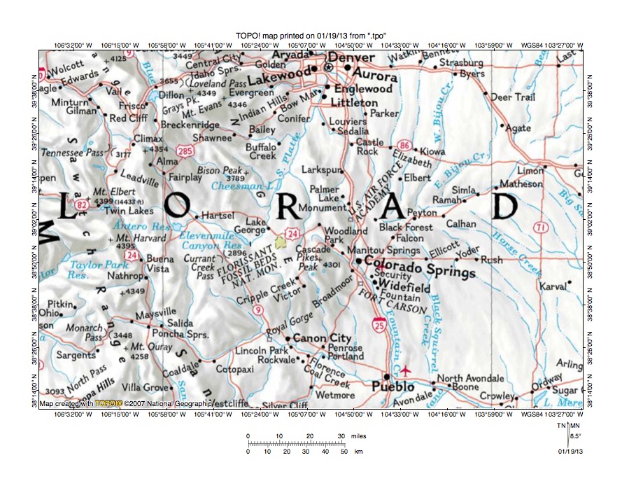
Figure 1: South Platte River-Arkansas River drainage divide area location map (select and click on maps to enlarge). National Geographic Society map digitally presented using National Geographic Society TOPO software.
Figure 1 provides a location map for the South Platte River-Arkansas River drainage divide area in northern El Paso County, Colorado and illustrates a region in east central Colorado. Denver is located near the north center edge of figure 1, Colorado Springs is south of Denver, and Pueblo is located near the south edge of figure 1. Tennessee Pass is located in the northwest quadrant of figure 1. The Arkansas River originates on the south side of Tennessee Pass and flows in a south-southeast direction to Coaldale and then in an east-northeast direction to near Royal Gorge before turning in a southeast direction to flow to Pueblo and the south edge of figure 1. South and east of figure 1 the Arkansas River flows in an east and southeast direction and eventually reaches the south oriented Mississippi River. Fountain Creek is a southeast and south oriented tributary originating near Woodland Park and flowing through Colorado Springs before joining the Arkansas River at Pueblo. East of Fountain Creek Black Squirrel Creek originates in the region between Black Forest and Peyton and then flows in a south direction to join the Arkansas River near North Avondale. Big Sandy Creek also originates in the Peyton area and flows in a northeast direction to Limon before turning in a southeast direction to flow to the east center edge of figure 1. East of figure 1 Big Sandy Creek flows in a southeast and south direction to join the Arkansas River. Alma is a town located east of Tennessee Pass. The Middle Fork South Platte River flows in a south-southeast direction from Alma to Hartsel where it joins the South Fork South Platte River to form the South Platte River, which then flows in a southeast direction to Elevenmile Canyon Reservoir before turning to flow in a north-northeast direction to Denver and the north edge of figure 1. North of figure 1 the South Platte River flows in a north-northeast direction before turning in a southeast, east, and northeast direction to flow into western Nebraska with water eventually reaching the Missouri River, which flows to the Mississippi River. North oriented streams flowing to the north edge of figure 1 east of Denver are South Platte River tributaries and join the southeast oriented South Platte River segment north of figure 1. El Paso County is the county in which Colorado Springs is located and includes the towns of Palmer Lake, Black Forest, and Peyton. Woodland Park is located just west of the El Paso County western border. The Rampart Range is located west of Colorado Springs and the region east of Colorado Springs is the Colorado Piedmont. The South Platte River-Arkansas River drainage divide area investigated in this essay is located east of Woodland Park and west of Peyton.
The South Platte River and Arkansas River drainage systems developed during immense melt water floods from the western margin of a thick North American ice sheet. Floodwaters flowed from western Canada to and across Colorado at a time when Colorado mountain ranges were beginning to emerge. Colorado mountain ranges emerged as floodwaters flowed across them, as ice sheet related crustal warping raised Colorado and mountain masses within Colorado, and as deep valley eroded headward into Colorado from both the east and the west. Floodwaters initially flowed in south directions, although flood flow directions changed as crustal warping blocked flood flow routes and as headward erosion of deep valleys beheaded south oriented flood flow channels. Floodwaters on north ends of beheaded flood flow channels frequently reversed flow direction to flow in north directions to the deeper beheading valley. The north-northeast oriented South Platte River drainage routes and the routes of north oriented South Platte River tributaries on the Colorado Piedmont originated as south oriented flood flow channels, which were captured by headward erosion of the Arkansas River valley. Headward erosion of the deep southeast, east, and northeast oriented South Platte River valley from western Nebraska into northern Colorado then beheaded and reversed south oriented flood flow channels on the Colorado Piedmont to create north oriented South Platte River tributary drainage routes and the north-northeast oriented South Platte River drainage route, which captured south and southeast oriented flood flow crossing emerging mountain regions further to the west. This massive flood flow reversal was probably greatly aided by crustal warping that was occurring as floodwaters flowed across the region. Subsequently headward erosion of the deep southwest oriented Colorado River valley (north of the northwest corner of figure 1) beheaded and reversed flood flow channels to the newly eroded south and southeast oriented Arkansas River and South Platte River headwaters valleys to create north and northwest oriented Colorado River tributary drainage routes seen in the northwest corner of figure 1.
Detailed location map for South Platte River-Arkansas River drainage divide area

Figure 2: Detailed location map for South Platte River-Arkansas River drainage divide area. United States Geological Survey map digitally presented using National Geographic Society TOPO software.
Figure 2 provides a detailed location map for the South Platte River-Arkansas River drainage divide area in northern El Paso County, Colorado. County lines are shown and El Paso County is labeled. Teller County is west of El Paso County. Green colored areas are National Forest lands and in figure 2 are located in the Rampart Range with the Colorado Piedmont being located east of the Rampart Range. The South Platte River can just barely be seen flowing in a north-northeast direction near the northwest corner of figure 2. Trout Creek is the north oriented stream flowing from Teller County to join the north-northeast oriented South Platte River near the northwest corner of figure 2. Trout Creek flows near Woodland Park (in Teller County, but near the Teller-El Paso County line). The southeast oriented stream flowing from near Woodland Park to Crystola, Chipita Park, Cascade, Manitou Springs, and Colorado Springs is Fountain Creek, which south of Colorado Springs flows in a south-southeast and south direction through Security and Fountain to the south edge of figure 2. South of figure 2 Fountain Creek flows to the Arkansas River. Palmer Lake is a town located along the north border of El Paso County and at the east edge of the Rampart Range. The northeast and south oriented stream with its elbow of capture near Palmer Lake and flowing along the U.S. Air Force Academy eastern boundary to join Fountain Creek at Colorado Springs is Monument Creek. The unlabeled north oriented stream originating near Palmer Lake is Carpenter Creek, which north of figure 2 joins north and northwest oriented Plum Creek, which joins the north-northeast oriented South Platte River. North oriented streams originating in northern El Paso County east of Palmer Lake include West Cherry Creek and East Cherry Creek, which join near the north edge of figure 2 to form north and northwest oriented Cherry Creek, which north of figure 2 joins the north-northeast oriented South Platte River at Denver. East of Table Rock are headwaters of north-northeast oriented West Kiowa Creek and Kiowa Creek, which join to form north-northeast and north oriented Kiowa Creek, which joins the southeast and east oriented South Platte River north of figure 2. The north-northeast oriented stream originating near Rattlesnake Butte is West Bijou Creek, which north of figure 2 flows to north and north-northeast oriented Bijou Creek, which also joins the southeast and east oriented South Platte River north of figure 2. The east oriented stream originating near Black Forest and flowing to near Peyton before turning a southeast and south direction to flow to the south edge of figure 2 (east of center) is Black Squirrel Creek, which south of figure 2 joins the Arkansas River. The east and northeast oriented stream flowing from near Rattlesnake Butte to the east edge of figure 2 (north half) is Big Sandy Creek, which east of figure 2 turns to flow in a southeast and south direction to join the Arkansas River.
Trout Creek-Fountain Creek drainage divide area

Figure 3: Trout Creek-Fountain Creek drainage divide area. United States Geological Survey map digitally presented using National Geographic Society TOPO software.
Figure 3 provides a topographic map of Trout Creek-Fountain Creek drainage divide area. The map contour interval for figure 3 is 50 meters. The eastern flank of the Rampart Range is located in the east half of figure 3 and the United State Air Force Academy and the town of Monument (near northeast corner of figure 3) are located on the Colorado Piedmont. The town of Woodland Park is located in the southwest quadrant of figure 3. Trout Creek flows west of Woodland Park in a north-northeast, north-northwest, and north direction from the south edge of figure 3 to the north edge of figure 3. North of figure 3 Trout Creek flows in a north and north-northwest direction to join the north-northeast oriented South Platte River. Fountain Creek originates on the south side of Woodland Park and flows in a south-southeast direction to Crystola on the south edge of figure 3. South of figure 3 Fountain Creek flows in a southeast and south direction to join the Arkansas River. Woodland Park is located in a through valley linking the north oriented Trout Creek valley with the south oriented Fountain Creek valley. The through valley floor elevation is between 2550 and 2600 meters. Elevations on the ridge west of Woodland Park rise to 2750 meters and elevations east of Woodland Park rise to more than 2800 meters suggesting the through valley is at least 150 meters deep. The through valley was eroded by south oriented flood flow moving from the present day north oriented Trout Creek and South Platte River alignment to the southeast and south oriented Fountain Creek valley. At that time the south oriented flood flow channel on the Trout Creek alignment split into two diverging flood flow channels just north of Woodland Park with one flood channel flowing on the present day Fountain Creek alignment in a southeast direction across what was then the emerging Rampart Range to reach the western margin of the Colorado Piedmont and then to flow in a south direction to reach the Arkansas River valley. The western diverging flood flow channel continued in a south-southwest direction on the present day north oriented Trout Creek alignment to the west side of the emerging Rampart Range and then continued in a south direction on the present day south oriented Fourmile Creek alignment to the Arkansas River valley. The reversal of flood flow in the South Platte River drainage basin created the north oriented Trout Creek drainage route and the Trout Creek-Fountain Creek drainage divide seen in figure 3 (and Trout Creek-Fourmile Creek drainage divide west and south of figure 3).
Detailed map of Trout Creek-Fountain Creek drainage divide area

Figure 4: Detailed map of Trout Creek-Fountain Creek drainage divide area. United States Geological Survey map digitally presented using National Geographic Society TOPO software.
Figure 4 provides a detailed topographic map of the Trout Creek-Fountain Creek drainage divide area seen in less detail in figure 3. The map contour interval for figure 4 is 40 feet. Woodland Park is located just north of the northeast quadrant of figure 4. The town of Crystola is located just south of the southeast corner of figure 4. Trout Creek flows in a northeast and north direction across the northwest corner of figure 4. North of figure 4 Trout Creek flows in a north and north-northwest direction to join the north-northeast oriented South Platte River. A north-northeast, northeast, and northwest oriented tributary flows from the south edge of figure 4 (west half) to the north edge of figure 4 (near Trout Creek) and joins Trout Creek north of figure 4. Fountain Creek flows in a south-southeast direction from section 30 to near the southeast corner of figure 4. South of figure 4 Fountain Creek flows in a southeast and south direction to eventually reach the Arkansas River. Crystola Creek flows in a northeast, east, and southeast direction from the south edge of figure 4 (west of center) to join Fountain Creek near the southeast corner of figure 4. Several through valleys or wind gaps can be seen near the Aspen Valley Ranch in section 25. One through valley links the northwest oriented Trout Creek tributary valley with a south-southeast oriented Crystola Creek tributary valley. The through valley floor elevation is between 8620 and 8660 feet. The ridge just to the north rises to more than 9040 feet and elevations greater than 9080 feet can be found near the south center edge of figure 4. These elevations suggest the through valley is at least 380 feet deep. An even deeper through valley just north of the Aspen Valley Ranch links the northwest oriented Trout Creek tributary valley with the south-southeast oriented Fountain Creek valley and has a floor elevation of between 8600 and 8640 feet. A narrower south-southwest oriented through valley or wind gap in the northwest quadrant of section 31 links the Fountain Creek valley with the southeast oriented Crystola Creek valley and has a floor elevation of between 8280 and 8320 feet. The ridge to the north rises to more than 8840 feet and the ridge to the south rises to more than 8720 feet suggesting the through valley is at least 400 feet deep. These and other similar through valleys or wind gaps found in the Woodland Park region are evidence of diverging and converging south oriented flood flow channels that once eroded the region. Flood flow across the region ended when floodwaters in the present day South Platte River drainage basin were beheaded and reversed to create the north-northeast oriented South Platte River and its north oriented Trout Creek tributary drainage routes.
Carpenter Creek-Monument Creek drainage divide area
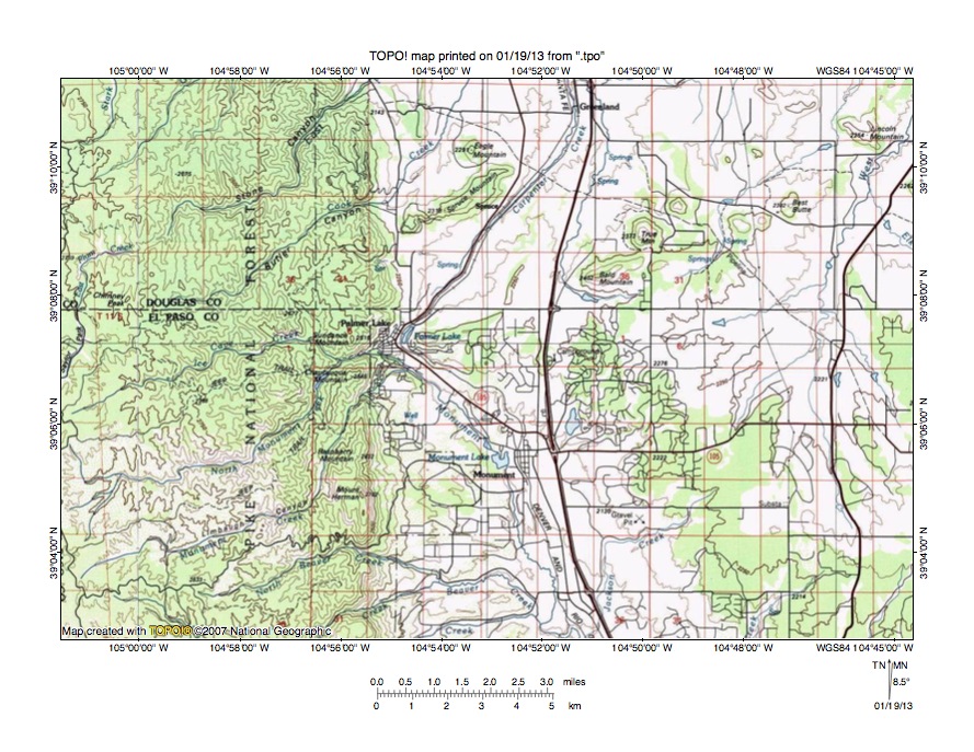
Figure 5: Carpenter Creek-Monument Creek drainage divide area. United States Geological Survey map digitally presented using National Geographic Society TOPO software.
Figure 5 illustrates a topographic map of the Carpenter Creek-Monument Creek drainage divide area north and east of figure 3 and includes an overlap area with figure 3. The map contour interval for figure 5 is 50 meters. Palmer Lake is the town located along the east flank of the Rampart Range near the center of figure 5. Monument Creek originates near the southwest corner of figure 5 and flows in an east-northeast and north-northeast direction to near Palmer Lake and then turns to flow in a south-southeast direction to the south center edge of figure 5. South of figure 5 Monument Creek joins south oriented Fountain Creek with water flowing to the Arkansas River. Carpenter Creek originates on the north side of Palmer Lake and flows in a north-northeast and north direction to the north center edge of figure 5 (near the town of Greenland). North of figure 5 Carpenter Creek joins north and northwest oriented Plum Creek with water flowing to the north-northeast oriented South Platte River. The East Fork Plum Creek flows in a northeast direction from near the west center edge of figure 5 through Stone Canyon to the north edge of figure 5 (west half). The north oriented Trout Creek valley is located a short distance west of the west edge of figure 5. A north-to-south oriented through valley links the north oriented Carpenter Creek valley with the south oriented Monument Creek valley. The through valley floor elevation at Palmer Lake is between 2200 and 2250 meters. Bald Mountain to the northeast rises to 2402 meters and elevations in the Rampart Range to the west rise even higher suggesting the through valley is at least 150 meters deep. In very simplistic terms the through valley was eroded by south oriented flood flow prior to the reversal of flood flow that created the north oriented Carpenter Creek and Plum Creek drainage routes. However, the northeast oriented Monument Creek and North Monument Creek headwaters and the northeast oriented Plum Creek headwaters seen in the Rampart Range suggest floodwaters at one time flowed in diverging and converging southwest oriented flood flow channels from the present day Colorado Piedmont region across what was an emerging Rampart Range to a deeper south oriented flood flow channel on the present day north oriented Trout Creek alignment (west of figure 5). Headward erosion of the deep south-southeast oriented Monument Creek valley along the east flank of the emerging Rampart Range beheaded and reversed the southwest oriented flood flow channels on the present day northeast oriented Monument Creek and North Monument Creek headwaters drainage routes. Subsequently floodwaters in the South Platte River drainage basin were beheaded and reversed to create the north-northeast oriented South Platte River drainage route and its north oriented Plum Creek and Carpenter Creek tributary drainage routes.
Detailed map of Carpenter Creek-Monument Creek drainage divide area

Figure 6: Detailed map of Carpenter Creek-Monument Creek drainage divide area. United States Geological Survey map digitally presented using National Geographic Society TOPO software.
Figure 6 provides a detailed topographic map of the Carpenter Creek-Monument Creek drainage divide area seen in less detail in figure 5. The map contour interval for figure 6 is 40 feet in the west half and 20 feet in the east half. Palmer Lake is located in the west center area of figure 6. Carpenter Creek flows in a north-northeast direction from Palmer Lake to the north edge of figure 6 (west of center). North of figure 6 Carpenter Creek turns to flow in a north direction to join north and northwest oriented Plum Creek with water flowing to the north-northeast oriented South Platte River. Monument Creek flows in an east-northeast direction from the west center edge of figure 6 and then turns to flow in a southeast direction to the south edge of figure 6 (west of center). South of figure 6 Monument Creek flows in a south direction to join south oriented Fountain Creek with water flowing to the Arkansas River. West of figure 6 Monument Creek originates near the edge of the deep north oriented Trout Creek valley and flows in a northeast direction to reach Palmer Creek where it turns to flow in a southeast and south direction. The Carpenter Creek-Monument Creek through valley at Palmer Lake has an elevation of between 7200 and 7240 feet. Ben Lombard Mountain in section 4 to the east rises to 7638 feet indicating the Palmer Lake through valley is approximately 400 feet deep. Bald Mountain in the northeast quadrant of figure 6 rises to 7881 feet suggesting the through valley could more than 640 feet deep. The region seen in figure 6 was once crossed by south oriented flood flow with a southeast and south oriented flood flow channel on the present day Monument Creek alignment diverging from a southwest oriented flood flow channel on the present day northeast oriented Monument Creek alignment (west of figure 6) and north-northeast and north oriented Carpenter Creek alignment. Headward erosion of a deeper valley on the southeast and south oriented Monument Creek alignment captured the south-southwest oriented flood flow channel on the present day north-northeast oriented Carpenter Creek and beheaded and reversed the southwest oriented flood flow channel on the present day northeast oriented Monument Creek headwaters alignment (west of figure 6). Subsequently a massive flood flow reversal in the South Platte River drainage basin reversed flood flow on the Carpenter Creek alignment to create the north-northeast oriented Carpenter Creek drainage route. The flood flow captures and reversals were probably greatly aided by crustal warping that was raising the Rampart Range west of figure 6 and that probably was also raising the present day South Platte River-Arkansas River drainage divide area.
Cherry Creek-Monument Creek drainage divide area
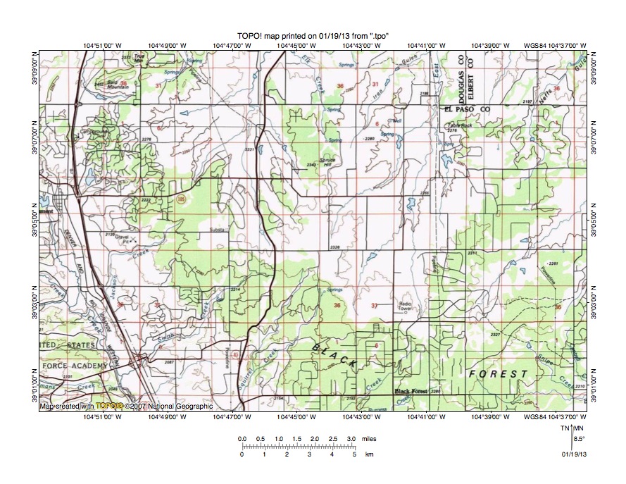
Figure 7: Cherry Creek-Monument Creek drainage divide area. United States Geological Survey map digitally presented using National Geographic Society TOPO software.
Figure 7 illustrates the Cherry Creek-Monument Creek drainage divide area east and slightly south of figure 5 and there is an overlap area with figure 5. The map contour interval for figure 7 is 50 meters. The United States Air Force Academy is located near the southwest corner of figure 7. Monument is the town just north of the west center edge of figure 7. Monument Creek flows in a south-southeast direction from Monument to the south edge of figure 7 (west half) and south of figure 7 joins south oriented Fountain Creek, which flows to the Arkansas River. Smith Creek is a southwest oriented tributary joining Monument Creek near the Air Force Academy. East of Smith Creek is south-southwest oriented Black Squirrel Creek, which joins Monument Creek south of figure 7 (the Black Squirrel Creek flowing to Monument Creek is different from the Black Squirrel Creek seen in figures 9 and 10, which directly flows to the Arkansas River). The southwest oriented stream flowing to the south center edge of figure 7 is Kettle Creek, which south of figure 7 flows to Monument Creek. The north oriented stream originating north of the Smith Creek headwaters is West Cherry Creek, which north of figure 7 joins East Cherry Creek to form north and north-northwest oriented Cherry Creek, which flows to Denver to join the north-northeast oriented South Platte River. East Cheery Creek originates north of the Kettle Creek headwaters and flows in a north direction to the north edge of figure 7 (east of center) and north of figure 7 joins West Cherry Creek to form north and north-northwest oriented Cherry Creek. The 50-meter contour interval for figure 7 does not show enough detail to illustrate shallow through valleys linking the north oriented Cherry Creek headwaters valleys with the southwest and south-southwest oriented Monument Creek tributary headwaters valleys. However, figure 7 does show how north oriented Cherry Creek headwaters drainage routes are on alignments corresponding with the southwest and south-southwest oriented Monument Creek tributary headwaters drainage routes. This evidence suggests large volumes of south oriented floodwaters (perhaps in large sheets of water) once crossed the region as southwest and south-southwest oriented tributary valleys eroded headward from the actively eroding and deeper south-southeast oriented Monument Creek valley. The reversal of flood flow in the South Platte River drainage basin reversed flood flow moving across the present day Black Forest region to create the north and north-northwest oriented Cherry Creek drainage system and to create the Cherry Creek-Monument Creek drainage divide seen in figure 7.
Detailed map of East Cherry Creek-Kettle Creek drainage divide area

Figure 8: Detailed map of East Cherry Creek-Kettle Creek drainage divide area. United States Geological Survey map digitally presented using National Geographic Society TOPO software.
Figure 8 provides a detailed topographic map of the East Cherry Creek-Kettle Creek drainage divide seen in less detail figure 7. The map contour interval for figure 8 is 20 feet. The two streams originating in the center region of figure 8 and flowing to the north center edge of figure 8 join north of figure 8 to form north oriented East Cherry Creek, which flows to join West Cherry Creek and to form north and north-northwest oriented Cherry Creek, which joins the north-northeast oriented South Platte River at Denver. The south-southwest oriented stream flowing to the south center edge of figure 8 is Kettle Creek, which south of figure 8 joins south oriented Monument Creek, which joins south oriented Fountain Creek, which in turn flows to the Arkansas River. A shallow north-to-south oriented through valley in the east half of section 5 links the north oriented East Cherry Creek valley with the south-southwest oriented Kettle Creek valley. The through valley floor elevation at the lowest point on the drainage divide is between 7600 and 7620 feet. Elevations east of the through valley rise to more than 7700 feet and along the west edge of figure 8 elevations along the drainage divide also rise to more than 7700 feet (and as seen in figures 5 and 6 rise much higher further to the west). These elevations suggest the East Cherry Creek-Kettle Creek through valley at its deepest point is at least 80 feet deep. The 7700-foot high elevations are approximately three miles apart (the sections are one mile squares) suggesting the through valley is broad and shallow and that the through valley was eroded by broad sheets of south oriented flood flow prior to the flood flow reversal in the South Platte River drainage basin. At that time the south-southwest oriented Kettle Creek valley was eroding headward from the deeper south oriented Monument Creek valley to capture the south oriented flood flow. The reversal of flood flow in the South Platte River drainage basin created the north oriented Cherry Creek and East Cherry Creek drainage route and the present day East Cherry Creek-Kettle Creek drainage divide. The South Platte River flood flow reversal occurred when the deep southeast, east, and northeast oriented South Platte River valley eroded headward into northeast Colorado and beheaded and reversed flood flow channels on the Colorado Piedmont. The flood flow reversal was probably greatly aided by crustal warping that was occurring as floodwaters flowed across the region.
Kiowa Creek-Black Squirrel Creek drainage divide area

Figure 9: Kiowa Creek-Black Squirrel Creek drainage divide area. United States Geological Survey map digitally presented using National Geographic Society TOPO software.
Figure 9 illustrates the Kiowa Creek-Black Squirrel Creek drainage divide area east of figure 7 and there is an overlap area with figure 7. The map contour interval for figure 9 is 50 meters. Kiowa Creek originates in the southwest quadrant of figure 9 (west of Eastonville) and flows in a northeast and north direction to the north center edge of figure 9. North of figure 9 Kiowa Creek flows in a north direction to join the southeast, east, and northeast oriented South Platte River in northeast Colorado. West Kiowa Creek originates in the southwest quadrant of figure 9 (near west edge) and flows in a northeast and north direction to the north edge of figure 9 (west half). North of figure 9 West Kiowa Creek joins north oriented Kiowa Creek to flow to the South Platte River. West Bijou Creek originates in the northeast quadrant of figure 9 and flows in a northeast direction to the north edge of figure 9 (east half). North of figure 9 West Bijou Creek flows in a northeast and north direction to join East Bijou Creek and to form north oriented Bijou Creek, which flows to the southeast, east, and northeast oriented South Platte River in northeast Colorado. Black Squirrel Creek originates near the southwest corner of figure 9 and flows in an east direction near the south edge of figure 9 to the south center edge of figure 9 where it turns to flow in a southeast direction. South of figure 9 Black Squirrel Creek flows in a southeast and then south direction to eventually join the Arkansas River. Brackett Creek is a southeast and south oriented Black Squirrel Creek tributary. The east-southeast and northeast oriented stream flowing to the east center edge of figure 9 is Big Sandy Creek, which east of figure 9 flows in a northeast direction before turning to flow in a southeast and then south direction to join the Arkansas River. Eastonville is located in a shallow north-to-south oriented through valley linking the north oriented Kiowa Creek valley with the east, southeast, and south oriented Black Squirrel Creek valley. The through valley is defined by one 50-meter contour line on the east side and by two 50-meter contour lines on the west side and suggesting it may be less than 50 meters deep. However, the alignment of the valleys and the presence of a shallow through valley provide evidence floodwaters once crossed the present day drainage divide. Floodwaters probably flowed in broad sheets of south oriented water to the south oriented Black Squirrel Creek valley, which was eroding headward from the Arkansas River valley. Headward erosion of the deep southeast, east, and northeast oriented South Platte River valley into northeast Colorado from western Nebraska beheaded and reversed the south oriented flood flow channels to create the north oriented West Kiowa Creek, Kiowa Creek, and West Bijou Creek drainage routes and the South Platte River-Arkansas River drainage divide.
Detailed map of Kiowa Creek-Black Squirrel Creek drainage divide area

Figure 10: Detailed map of Kiowa Creek-Black Squirrel Creek drainage divide area. United States Geological Survey map digitally presented using National Geographic Society TOPO software.
Figure 10 provides a detailed topographic map of the Kiowa Creek-Black Squirrel Creek drainage divide area seen in less detail in figure 9. The map contour interval for figure 10 is 20 feet. Kiowa Creek flows in a northeast direction across the northwest corner of figure 10. North of figure 10 Kiowa Creek flows in a northeast and north direction to eventually join the southeast, east, and northeast oriented South Platte River in northeast Colorado. Black Squirrel Creek flows in an east-northeast and east-southeast direction near the south center edge of figure 10 and south of figure 10 flows in a southeast and south direction to eventually join the Arkansas River. Eastonville is a small town located in section 28. An old railroad line extends from the south edge of figure 10 through Eastonvillle to the north edge of figure 10. In the northwest corner of section 27 (near the north edge of figure 10) the old railroad line crosses the Kiowa Creek-Black Squirrel Creek drainage divide at an elevation of 7264 feet. Further east in section 27 elevations rise to more than 7420 feet and near the west center edge of figure 10 an elevation of 7524 feet can be seen. These elevations suggest the old railroad line crosses the Kiowa Creek-Black Squirrel Creek drainage divide in a through valley that is at least 156 feet deep. This 156-foot deep through valley is a water-eroded feature and was eroded by south oriented flood flow moving from the present day north oriented Kiowa Creek alignment to what at that time was the actively eroding south oriented Black Squirrel Creek valley. Headward erosion of the deep southeast, east, and northeast oriented South Platte River valley into northeast Colorado from western Nebraska beheaded and reversed south oriented flood flow channels on the Colorado Piedmont to create north oriented South Platte River tributary drainage routes including the north oriented Kiowa Creek drainage route. The flood flow reversal may have been aided by crustal warping that raised the South Platte River-Arkansas River drainage divide as floodwaters flowed across it.
Additional information and sources of maps studied
This essay has provided only a sample of the detailed topographic map evidence supporting the flood erosion interpretation. Many additional illustrations could be provided. Readers are encouraged to look at mosaics of detailed topographic maps to see the abundance of available data. Maps used in this study were created and published by the United States Geologic Survey and can be obtained directly from the United States Geological Survey and/or from dealers offering United States Geological Survey maps. Hard copy maps can also be observed at United States Geological Survey map depositories, which are located throughout the United States and elsewhere. Illustrations used here were created using National Geographic Society TOPO software and digital map data. TOPO software and map data can be obtained from the National Geographic Society and/or dealers offering National Geographic Society digital map data.

Leave a comment