
Abstract:
This essay uses topographic map evidence to interpret landform origins in the Trout Creek-Arkansas River drainage divide area in Park, Teller, and El Paso Counties, Colorado. Trout Creek is a north and north-northwest oriented tributary flowing to the north-northeast oriented South Platte River and is linked by through valleys with southeast oriented Fountain Creek on the east side of Pikes Peak and with south, southwest, and south oriented Fourmile Creek on the west side of Pikes Peak, with Fountain Creek and Fourmile Creek flowing to the Arkansas River. Fountain Creek has eroded a deep water gap across the Rampart Range in which Pikes Peak is located. Diverging south oriented flood flow channels during immense melt water floods from the western margin of a thick North American ice sheet eroded the south oriented Fountain Creek and Fourmile Creek valleys. Floodwaters flowed from western Canada to and across Colorado at a time when Colorado mountain ranges were beginning to emerge. Colorado mountain ranges emerged as floodwaters flow across them, as ice sheet related crustal warping raised Colorado and the mountain masses, and as deep valleys eroded headward into Colorado from both the east and the west. Uplift of the Rampart Range occurred as southeast oriented floodwaters flowed across it and eroded a deeper and deeper valley on the present day Fountain Creek alignment. West of the Rampart Range (which is west of Pikes Peak) a much broader and deeper valley was eroded by the south oriented flood flow. Deep erosion in that region may have triggered volcanic activity, which resulted in the formation of constructional landforms. Uplift and possibly volcanic activity raised the present day South Platte River-Arkansas River drainage divide area as the deep southeast and northeast oriented South Platte River valley, which eroded into northeast Colorado from western Nebraska, beheaded south oriented flood flow channels on the Colorado Piedmont. Floodwaters on north ends of the beheaded flood flow channels reversed flow direction to flow in a north direction to the deeper southeast and northeast oriented South Platte River valley and to create north oriented South Platte River tributary drainage routes and the north-northeast oriented South Platte River drainage route, which captured south and southeast oriented flood flow from the mountain regions further to the west. Headward erosion of the deep southwest oriented Colorado River valley subsequently beheaded and reversed south and southeast oriented flood flow channels to the newly reversed South Platte River and to the south-southeast, east-northeast, and southeast oriented Arkansas River.
Preface
The following interpretation of detailed topographic map evidence is one of a series of essays describing similar evidence for all major drainage divides contained within the Missouri River drainage basin and for all major drainage divides with adjacent drainage basins. The research project is interpreting evidence in the context of a previously unexplored deep glacial erosion paradigm, which is fundamentally different from most commonly accepted North American glacial history interpretations. Project essays are listed on the sidebar category list under their appropriate Missouri River tributary drainage basin, Missouri River segment drainage basin (by state), and/or state in which the Missouri River drainage basin is located.
Introduction
The purpose of this essay is to use topographic map interpretation methods to explore the Trout Creek-Arkansas River drainage divide area landform origins in Park, Teller, and El Paso Counties, Colorado. Map interpretation methods can be used to unravel many geomorphic events leading up to formation of present-day drainage routes and development of other landform features. While each detailed topographic map feature provides detailed evidence to be explained, the solution must be consistent with explanations for adjacent area map evidence as well as solutions to big picture map evidence puzzles. I invite readers to improve upon my solutions and/or to propose alternate solutions that better explain evidence and are also consistent with adjacent map area and big-picture evidence. Readers may do so either by making comments here or by writing and publishing their own essays and then by leaving a link to those essays in a comment here.
This essay is also exploring a new geomorphology paradigm in which erosional landforms are interpreted as evidence left by immense glacial melt water floods. Implied in that interpretation is the immense floods were derived from a thick North American ice sheet that created a deep “hole” in the North American continent and also melted fast. The previously unexplored paradigm being tested in this and other Missouri River drainage basin landform origins research project essays is a thick North American ice sheet, comparable in thickness to the Antarctic ice sheet, occupied the North American region usually recognized to have been glaciated, and through its weight and erosive actions created a deep North American “hole”. The southwestern rim of that deep “hole” is today preserved in the high Rocky Mountains. The ice sheet through its weight and deep erosion (and perhaps deposition along major south-oriented melt water flow routes) caused significant crustal warping and tectonic change, through its action of melting fast produced immense floods that flowed across the continent, and through its action of melting fast systematically opened up space in the ice sheet created “hole” so headward erosion of newly developed north-oriented drainage systems captured immense south-oriented melt water floods and diverted immense melt water floods north into space the ice sheet had once occupied.
If this previously unexplored paradigm is correct the geographic region explored by this essay should contain evidence of immense floods that were captured by headward erosion of new valley systems so as to cause the floods to flow in a different direction. Ability of this previously unexplored paradigm to explain Trout Creek-Arkansas River drainage divide area landform evidence in Park, Teller, and El Paso Counties, Colorado will be regarded as evidence supporting the “thick ice sheet that melted fast” paradigm.
Trout Creek-Arkansas River drainage divide area location map

Figure 1: Trout Creek-Arkansas River drainage divide area location map (select and click on maps to enlarge). National Geographic Society map digitally presented using National Geographic Society TOPO software.
Figure 1 provides a location map for the Trout Creek-Arkansas River drainage divide area in Park, Teller, and El Paso Counties, Colorado and illustrates a region in central Colorado. Tennessee Pass is located in the northwest quadrant of figure 1. The Arkansas River originates on the south side of Tennessee Pass and flows in a south-southeast direction to Coaldale. From Coaldale the Arkansas River flows in an east-northeast direction to near Royal Gorge where it turns to flow in southeast and east-southeast direction to Pueblo and the south edge of figure 1 (east half). South and east of figure 1 the Arkansas River flows in a southeast direction to eventually reach the south oriented Mississippi River. Fountain Creek is a south oriented tributary flowing from near Woodland Park (north of Colorado Springs) to join the Arkansas River near Pueblo. Other unlabeled south oriented Arkansas River tributaries are located west of Fountain Creek, with Fourmile Creek being the south oriented tributary joining the Arkansas River near Canon City. Alma is a town east of Tennessee Pass. The Middle Fork South Platte River originates north of Alma and flows in a south and south-southeast direction to Hartsel where it joins the South Fork South Platte River to form the southeast oriented South Platte River, which flows to Elevenmile Canyon Reservoir. At the southeast end of Elevenmile Canyon Reservoir the South Platte River makes an abrupt turn to flow in a north-northeast direction to Denver and the north edge of figure 1. North of figure 1 (near Greeley) the South Platte River turns to flow in a southeast and then northeast direction to flow into western Nebraska with water eventually reaching the south oriented Mississippi River. The Florissant Fossil Beds National Monument is located east of Elevenmile Canyon Reservoir and the town of Woodland Park is located east of the Florissant Fossil Beds National Monument. The unlabeled north and north-northwest oriented South Platte River tributary originating between the Florissant Fossil Beds National Monument and Woodland Park is Trout Creek. The Trout Creek-Arkansas River drainage divide area investigated in this essay extends from the Florissant Fossil Beds National Monument to east of Woodland Park and includes the Trout Creek-Fountain Creek and the Trout Creek-Fourmile Creek drainage divides and the Pikes Peak region.
The South Platte River and Arkansas River drainage routes and their tributary drainage routes developed during immense melt water floods from the western margin of a thick North American ice sheet. Floodwaters flowed from western Canada to and across Colorado at a time when Colorado mountain ranges were beginning to emerge. Colorado mountain ranges emerged as floodwaters flowed across them, as ice sheet related crustal warping raised Colorado and the mountain masses, and as deep valleys eroded headward into Colorado from the Gulf of Mexico and from the Pacific Ocean. Initially floodwaters flowed in south directions, but flood flow directions changed as crustal warping raised Colorado and mountain regions in Colorado and as deep valleys beheaded south oriented flood flow channels. Floodwaters on north ends of beheaded flood flow channels reversed flow direction to flow in north directions to the deeper beheading valley. The north-northeast oriented South Platte River drainage route north of Lake George and the north and north-northwest oriented Trout Creek drainage route originated as diverging south oriented flood flow channels. South oriented flood flow on the Trout Creek alignment flowed to the south oriented Fountain Creek valley and also to the south oriented Fourmile Creek valley while south oriented flood flow on the South Platte River alignment flowed to the south oriented Fourmile Creek valley. The Rampart Range where Pikes Peak is located is located between these two diverging and converging flood flow channels, which had been captured by headward erosion of the deep Arkansas River valley. Crustal warping (and possibly volcanic activity) raised the present day South Platte River-Arkansas River drainage divide while at the same time headward erosion of a deep southeast and northeast oriented South Platte River valley from western Nebraska in northeast Colorado (north of figure 1) beheaded south oriented flood flow channels to the newly eroded Arkansas River valley. Floodwaters on north ends of the beheaded flood flow channels reversed flow direction to create north oriented South Platte River tributary drainage routes and the north-northeast oriented South Platte River drainage route, which then captured south and southeast oriented flood flow still moving across emerging mountain regions to the west. Headward erosion of the deep southwest oriented Colorado River valley (north of the northwest corner of figure 1) next beheaded and reversed south and southeast oriented flood flow channels flowing to the newly reversed South Platte River and created north and northwest oriented Colorado River tributary drainage routes (seen in the northwest corner of figure 1).
Detailed location map for Trout Creek-Arkansas River drainage divide area

Figure 2: Detailed location map for Trout Creek-Arkansas River drainage divide area. United States Geological Survey map digitally presented using National Geographic Society TOPO software.
Figure 2 provides a detailed location map for the Trout Creek-Arkansas River drainage divide area in Park, Teller, and El Paso Counties, Colorado. County lines are shown and Teller County is labeled. Park County is west of Teller County and El Paso County is east of Teller County. Green colored areas are National Forest lands and are primarily located in mountain regions. Colorado Springs is the city located near the southeast corner of figure 2. Elevenmile Canyon Reservoir is located in the southwest quadrant of figure 2. The South Platte River flows in a southeast direction from the west center edge of figure 2 to Elevenmile Canyon Reservoir and then turns to flow in a northeast direction through Elevenmile Canyon to Lake George. From Lake George the South Platte River flows in a north-northeast direction to the north center edge of figure 2. The Florissant Fossil Beds National Monument is located east of Elevenmile Canyon Reservoir and the town of Florissant is just north of the National Monument. The town of Divide is east of Florissant. Twin Creek originates near Divide and flows in a west direction to Florissant and then a northwest direction to join the South Platte River near Lake George. The north and north-northeast oriented stream just east of Divide is Rule Creek, which flows to Trout Creek. Trout Creek originates a short distance east of the Rule Creek headwaters and flows in a north and north-northwest direction to join the South Platte River north of the north edge of figure 2. The northeast and southeast oriented stream originating near the Trout Creek headwaters and flowing to the town of Crystola is Crystola Creek, which joins southeast oriented Fountain Creek at Crystola. Fountain Creek originates near Woodland Park and flows in a southeast direction to the east edge of figure 2 (south half). East and south of figure 2 Fountain Creek flows to the Arkansas River. Pikes Peak is located west of Colorado Springs in the southeast quadrant of figure 2 and the town of Midland is located west of Pikes Peak. Fourmile Creek flows in a northwest and south direction to Midland and then in a south, west, southwest, and south direction to the south center edge of figure 2. South of figure 2 Fourmile Creek flows in a south direction to the Arkansas River. Cripple Creek is a town located near the south edge of figure 2 just east of Fourmile Creek and Gillett is a town located north and east of Cripple Creek. The south oriented stream flowing from near Pikes Peak through Gillett to the south edge of figure 2 is Beaver Creek, which south of figure 2 flows to the Arkansas River. Topographic maps seen below illustrate deep north-to-south oriented through valleys on either side of the Rampart Range (not labeled in figure 2) where Pikes Peak is located. East of the Pikes Peak section of the Rampart Range is a north-to-south oriented through valley linking the north and north-northwest oriented Trout Creek valley with the southeast and south oriented Fountain Creek valley. West of the Pikes Peak section of the Rampart Range is a north-to-south oriented through valley linking the north oriented Rule Creek valley with the south oriented Beaver Creek valley and still further west is an even deeper north-to-south oriented through valley linking the northwest oriented Twin Creek valley (and north-northeast oriented South Platte River valley) with the south oriented Fourmile Creek valley.
Trout Creek-Fountain Creek drainage divide area
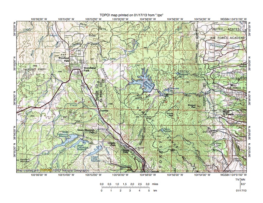
Figure 3: Trout Creek-Fountain Creek drainage divide area. United States Geological Survey map digitally presented using National Geographic Society TOPO software.
Figure 3 provides a topographic map of Trout Creek-Fountain Creek drainage divide area. The map contour interval for figure 3 is 50 meters. Pikes Peak is located a short distance south of the southwest quadrant of figure 3. Woodland Park is a town located in the northwest quadrant of figure 3. Fountain Creek originates on the southeast side of Woodland Park and then flows in a south-southeast direction to the south center edge of figure 3. South of figure 3 Fountain Creek flows in a southeast and south direction to join the Arkansas River. Chipita Park is a town in the Fountain Creek valley near the south center edge of figure 3 and is located in a deep canyon or water gap Fountain Creek has eroded to cross the Rampart Range. Fountain Creek crosses the 2300-meter contour line near the south center edge of figure 3. Elevations east of Chipita Park rise to 2946 meters and west of Chipita Park (near south edge of figure 3) elevations exceed 3000 meters suggesting the Fountain Creek water gap is approximately 650 meters deep. Trout Creek flows in a north-northeast and north direction from the west edge of figure 3 (south half) to the north edge of figure 3 (west half). North of figure 3 Trout Creek flows in a north and north-northwest direction to join the north-northeast oriented South Platte River. A north-to-south oriented through valley at Woodland Park links the north oriented Trout Creek valley with the south oriented Fountain Creek valley. The through valley floor elevation is between 2550 and 2600 meters and elevations on either side of the through valley rise to more than 2750 meters. While not deep compared to the much deeper Fountain Creek canyon to the south the through valley is evidence the Fountain Creek canyon was eroded by south oriented flood flow from the present day north oriented Trout Creek alignment. The south oriented floodwaters split near the Woodland Park location with one flood flow channel proceeding in a south-southeast direction on the east side of the emerging Rampart Range section including Pikes Peak and the other flood flow channel proceeding in a south-southwest direction on the west side of the Pikes Peak section of the Rampart Range. Apparently the Rampart Range was emerging as floodwaters flowed across the region and the south-southeast oriented flood flow channel on the Fountain Creek alignment eroded a deeper and deeper valley into the emerging Rampart Range. The massive flood flow reversal that created the north-northeast oriented South Platte River drainage route also reversed flood flow on the Trout Creek drainage route to create the present day Trout Creek-Fountain Creek drainage divide at Woodland Park.
Detailed map of Fountain Creek Canyon area

Figure 4: Detailed map of Fountain Creek Canyon area. United States Geological Survey map digitally presented using National Geographic Society TOPO software.
Figure 4 provides a detailed topographic map of the Fountain Creek-Canyon area seen in less detail in figure 3. The map contour interval for figure 4 is 40 feet. Pikes Peak is located south and west of figure 4 and rises to more than 14,000 feet. The Pikes Peak Toll Road leaves the main highway at Cascade and then proceeds in a west direction to the west edge of figure 4. Fountain Creek flows in a southeast, south, and east direction from the north edge of figure 4 (west of center) to the southeast corner of figure 4. South and east of figure 4 Fountain Creek flows in a southeast and south direction to join the Arkansas River. In the northeast corner of section 22 Fountain Creek crosses the 7480-foot contour line. Elevations in section 14 to the northeast rise to more than 9520 feet and elevations in the southwest corner of section 20 to the west rise to 9526 feet. South and west of figure 4 elevations rise to more than 14,000 feet and north of section 14 (and north of figure 4) elevations rise to more than 9640 feet. These elevations suggest the Fountain Creek canyon at the towns of Chipita Park and Cascade is at least 2000 feet deep. The water that eroded this deep canyon came from the north. But, as seen in figure 3 the present day Fountain Creek drainage basin north of figure 4 is relatively small and could not be expected to produce the volumes of water required to erode the 2000-foot deep canyon seen in figure 4. The only reasonable explanation for the source of the large volumes of water is the water flowed in a south direction on the present day north oriented Trout Creek and South Platte River alignments. Large volumes of water flowed from the present day north oriented Trout Creek and South Platte River alignments to the south oriented Fountain Creek valley and eroded a deeper and deeper valley into the Rampart Range, which was emerging as floodwaters flowed across it. After the deep canyon had been eroded the south oriented flood flow ceased, which is consistent with a massive reversal of flood flow on the Trout Creek and South Platte River alignments.
Catamount Creek- Fourmile Creek drainage divide area
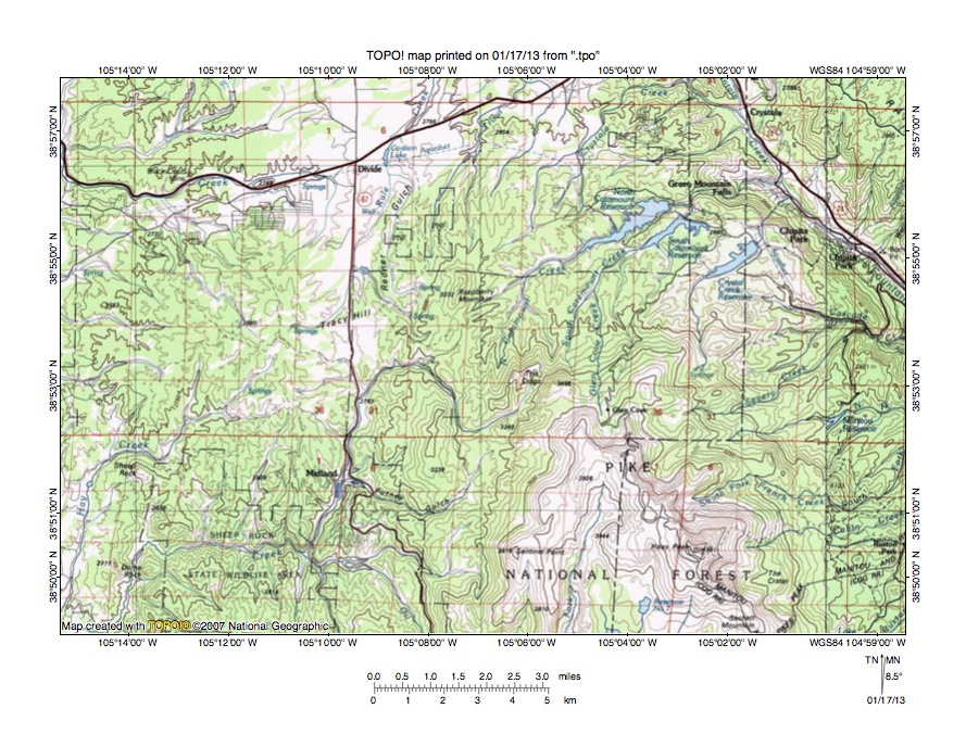
Figure 5: Catamount Creek-Fourmile Creek drainage divide area. United States Geological Survey map digitally presented using National Geographic Society TOPO software.
Figure 5 illustrates a topographic map of the Catamount Creek-Fourmile Creek drainage divide area south and west of figure 3 and includes an overlap area with figure 3. The map contour interval for figure 5 is 50 meters. Fountain Creek flows in the deep Fountain Creek Canyon across the northeast corner of figure 5. North and South Catamount Reservoirs and the Crystal Creek Reservoir can be seen in the northeast quadrant of figure 5 and flood the northeast oriented valleys of north-northeast and northeast oriented North Catamount Creek, north and northeast oriented South Catamount Creek, and north and northeast oriented Crystal Creek. North and South Catamount Reservoirs drain to east oriented Catamount Creek, which enters the Fountain Creek valley at Green Mountain Falls and Crystal Creek flows in a north and northeast direction across the Fountain Creek canyon wall. The fact these streams flow across the Fountain Creek canyon wall is evidence water that eroded the Fountain Creek canyon did not come from these streams. Pikes Peak is located in the southeast quadrant of figure 5 and is the highest point in the region. Midland is a town west of Pikes Peak and south of Tracy Hill. Fourmile Creek originates south of the Crags (which is south of the North Catamount Creek headwaters) and flows in a southwest, northwest and south direction to Midlandand then in a south, west, and south direction to the south edge of figure 5 (near southwest corner). South of figure 5 Fourmile Creek flows to the Arkansas River. Hay Creek originates on the southwest side of Tracy Hill and flows in a southwest and south-southwest direction to the southwest corner of figure 5 and south of figure 5 joins Fourmile Creek. Raspberry Mountain is located east of Tracy Hill. Trout Creek originates north of Raspberry Hill and flows in a north-northeast direction to the north edge of figure 5 (slightly east of center). North of figure 5 Trout Creek flows in a north and north-northwest direction to join the north-northeast oriented South Platte River. Just west of the Trout Creek headwaters are north oriented Rule Creek and its Redner Gulch tributary, which flow to the north center edge of figure 5. North of figure 5 Rule Creek flows to north and north-northwest oriented Trout Creek. The town of Divide is north of Tracy Hill. The north and west oriented stream originating near Divide is Twin Creek, which flows to the west edge of figure 5 (north half). West of figure 5 Twin Creek turns to flow in a northwest direction to join the north-northeast oriented South Platte River. West of Tracy Hill elevations decrease to just beyond the west edge of figure 5 and then elevations along the South Platte River-Arkansas River drainage divide increase to 3520 meters at Thirtynine Mile Mountain. Figure 7 better illustrates the deeper north-to-south oriented through valley near the west edge of figure 5. A shallower, but equally significant north-to-south oriented through valley is located at Tracy Hill and links the north oriented Trout Creek and Rule Creek headwaters valleys with the south oriented Fourmile Creek valley. The through valley has a floor elevation of between 2800 and 2850 meters. Elevations to the west rise to more than 2950 meters while Raspberry Mountain to the east rises to 3232 meters suggesting the through valley is at least 100 meters deep. This north-to-south oriented through valley was eroded by south oriented flood flow diverging from the southeast oriented flood flow channel that eroded the deep Fountain Creek canyon valley. Note how these two diverging flood flow channels surround the present day Pikes Peak mountain mass.
Detailed map of North Catamount Creek-Fourmile Creek drainage divide area
Figure 6: Detailed map of North Catamount Creek-Fourmile Creek drainage divide area. United States Geological Survey map digitally presented using National Geographic Society TOPO software.
Figure 6 provides a detailed topographic map of the North Catamount Creek-Fourmile Creek drainage divide area seen in less detail in figure 5. The map contour interval for figure 6 is 40 feet. The Pikes Peak mountain mass is located near the southeast corner of figure 6 and Pikes Peak itself is located south and east of figure 6. The Crags is located in the northeast quadrant of figure 6 at the north end of the Pikes Peak mountain mass (Rampart Range). North oriented streams flowing to the northeast corner of figure 6 are headwaters of South Catamount Creek and the north oriented stream north of the Crags is the headwaters of North Catamount Creek. North of figure 6 North and South Catamount Creeks flow to east oriented Catamount Creek, which flows to southeast and south oriented Fountain Creek, which in turn flows to the Arkansas River. The north oriented North and South Catamount Creek headwaters are flowing on alignments of what began as south oriented flood flow channels. Headward erosion of the east oriented Catamount Creek valley beheaded and reversed the south oriented flood flow. The reversals of flood flow on the Catamount Creek headwaters may have been caused by local crustal warping and valley erosion and may not be related to larger-scale flood flow reversals. Raspberry Mountain can be seen near the north center edge of figure 6 and Tracy Hill is west of Raspberry Mountain. North oriented streams flowing to the north edge of figure 6 west of Raspberry Mountain are headwaters of north oriented Rule Creek, which flows to north and north-northwest oriented Trout Creek, which then flows to the north-northeast oriented South Platte River. Fourmile Creek originates on the south side of the Crags and flows in a southwest, north, northwest, southwest, and south direction to Midland in the southwest quadrant of figure 6. Fourmile Creek flows in a south-southwest direction from Midland to the south edge of figure 6. South of figure 6 Fourmile Creek flows in a west and southwest direction before turning to flow in a south direction to join the Arkansas River. Putney Gulch originates in section 4 (in southeast quadrant of figure 6) and drains in a southwest and northwest direction to join Fourmile Creek at Midland. While difficult to see on figure 6 the north-to-south oriented highway crossing Tracy Hill is located in a north-to-south oriented through valley linking the north oriented Rule Creek valley with the south oriented Fourmile Creek valley. The through valley floor at the lowest point on the drainage divide has an elevation of slightly less than 9400 feet. A hill near the northwest corner of figure 6 rises to 9843 feet and Raspberry Mountain rises to more than 10,000 feet suggesting the through valley is at least 443 feet deep. A 700-foot deep or deeper northeast-to-southwest oriented through valley near the northeast corner of section 29 (south of Raspberry Mountain) links a southwest oriented Fourmile Creek tributary valley with a northeast oriented North Catamount Creek headwaters valley. Other through valleys can be found in figure 6. The Rule Creek-Fourmile Creek drainage divide was created by the reversal of flood flow that created the north oriented South Platte River and Trout Creek drainage routes. Crustal warping that was raising the region seen in figure 6 probably played a significant role in the massive South Platte River and Trout Creek flood flow reversal.
Twin Creek-Fourmile Creek drainage divide area

Figure 7: Twin Creek-Fourmile Creek drainage divide area. United States Geological Survey map digitally presented using National Geographic Society TOPO software.
Figure 7 illustrates the Twin Creek-Fourmile Creek drainage divide area west and slightly south of figure 5 and there is an overlap area with figure 5. The map contour interval for figure 7 is 50 meters. The town of Divide is located near the northeast corner of figure 7. Rule Creek originates south of Divide and flows in a north direction (on east side of Divide) to the north edge of figure 7 and north of figure 7 joins north and north-northwest oriented Trout Creek, which flows to the north-northeast oriented South Platte River. Twin Creek originates near Divide and flows in a west direction to Florissant (near north edge of figure 7) and the north edge of figure 7. North of figure 7 Twin Creek flows in a northwest direction to join the north-northeast oriented South Platte River. The Florissant Fossil Beds National Monument is located south of the town of Florissant. The north and north-northwest oriented stream flowing through the Florissant National Monument to join Twin Creek just west of Florissant is Grape Creek. Tracy Hill is south of Divide and Midland is south of Tracy Hill. Fourmile Creek flows from the east center edge of figure 7 in a northwest, southwest and south direction to Midland and then in a south-southwest, west, south, and southwest direction to the south center edge of figure 7. South of figure 7 Fourmile Creek flows in a south direction to join the Arkansas River. Oil Creek is a north-northwest Fourmile Creek flowing from the southeast corner of figure 7. Hay Creek originates on the southwest side of Tracy Hill and flows in a southwest and south direction to join Fourmile Creek near the south center edge of figure 7. South of the Florissant Fossil Beds National Monument is the drainage divide between north oriented Grape Creek (with water flowing to the north oriented South Platte River) and south oriented Hay Creek (with water flowing to the southeast oriented Arkansas River). A north-to-south oriented through valley links the two opposing drainage routes and has an elevation of 2615 meters. Elevations east of the through valley and seen in figure 7 rise to more than 2900 meters and elevations west of the through valley and seen in figure 7 rise to 2825 meters suggesting the through valley is at least 200 meters deep. However, as seen in earlier figures elevations on the drainage divide east of the through valley rise to elevations exceeding 4000 meters and elevations on the drainage divide not seen in this essay at Thirtynine Mile Mountain rise to 3520 meters. Based on these more distant elevation the through valley is probably just a deep channel on the floor of a much broader and deeper through valley that could be as much as 900 meters deep. This huge north-to-south oriented through valley is at least to some extent a water-eroded valley and was eroded by gigantic quantities of south oriented flood flow prior to the reversal of flood flow that created the present day north oriented South Platte River drainage system. The size of the through valley suggests the south oriented floodwaters were captured by headward erosion of the deep Arkansas River valley (south of figure 7).
Detailed map of Grape Creek-Hay Creek drainage divide area
Figure 8: Detailed map of Grape Creek-Hay Creek drainage divide area. United States Geological Survey map digitally presented using National Geographic Society TOPO software.
Figure 8 provides a detailed topographic map of the Grape Creek-Hay Creek drainage divide area seen in less detail in figure 7. The map contour interval for figure 8 is 40 feet. The north center area of figure 8 is located in the Florissant Fossil Beds National Monument. Hay Creek flows in a southwest direction across the southeast corner of figure 8. South of figure 8 Hay Creek flow in a southwest and south direction to join south oriented Fourmile Creek, which flows to the Arkansas River. Unlabeled south oriented streams flowing to the south edge of figure 8 are tributaries to Hay Creek or to Fourmile Creek. North oriented streams flowing to the north center edge of figure 8 are tributaries to north and north-northwest oriented Grape Creek, which flows to northwest oriented Twin Creek, which flows to the north-northeast oriented South Platte River. A north-to-south oriented through valley near the center of figure 8 links a north oriented Grape Creek tributary valley with a south oriented Hay Creek tributary valley. The through valley floor elevation at the drainage divide is between 8560 and 8600 feet. Elevations in section 34 along the west edge of figure 8 rise to more than 9080 feet and elevations in section 29 to the east of the through valley rise to 9174 feet suggesting the through valley is at least 480 feet deep. But as described in the figure 7 discussion this north-to-south oriented through valley is probably a deep channel on the floor of a much broader and deeper north-to-south oriented through valley between Thirtynine Mile Mountain on the west and Pikes Peak on the east. Thirtynine Mile Mountain rises to 11,548 feet and Pikes Peak rises to 14,170 feet suggesting the broader and deeper north-to-south oriented through valley could be almost 3000 feet deep. This huge north-to-south oriented through valley links the north oriented South Platte River drainage basin with the southeast oriented Arkansas River drainage basin. Vast quantities of south oriented floodwaters were required to erode a valley of this magnitude. South oriented flood flow ended as the South Platte River-Arkansas River drainage divide area was raised by crustal warping and possibly volcanic activity and as headward erosion of the deep southeast and northeast oriented South Platte River valley from western Nebraska into northeast Colorado beheaded and reversed flood flow on the present day north-northeast oriented South Platte River drainage route.
Oil Creek-West Fork Beaver Creek drainage divide area
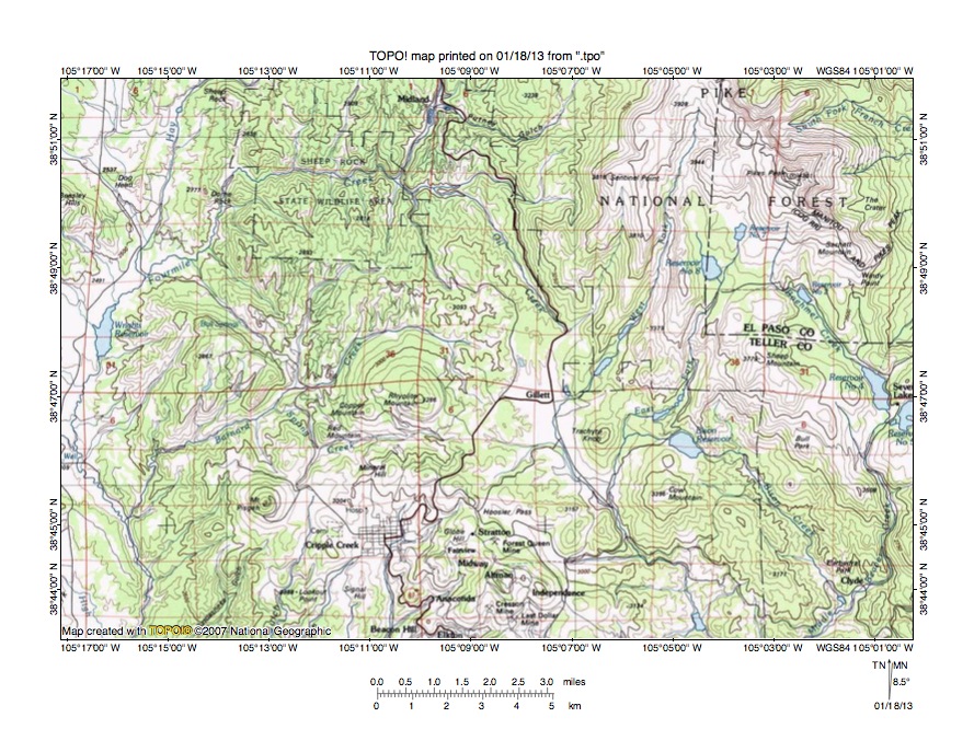
Figure 9: Oil Creek-West Fork Beaver Creek drainage divide area. United States Geological Survey map digitally presented using National Geographic Society TOPO software.
Figure 9 illustrates the Oil Creek-West Fork Beaver Creek drainage divide area south and east of figure 7 and there is an overlap area with figure 7. The map contour interval for figure 9 is 50 meters. Pikes Peak is located near the northeast corner of figure 9. Midland is located near the north center edge of figure 9. Fourmile Creek flows in a south direction to Midland and then in a south, west, south, south-southwest, and south direction to the south edge of figure 9 (near southwest corner). South of figure 9 Fourmile Creek flows in a south direction to join the Arkansas River. Cripple Creek is a town slightly west of the south center area of figure 9. North of Cripple Creek is Rhyolite Mountain and west of Cripple Creek is Mount Pisgah. East of Cripple Creek are Cow Mountain and Trachyte Knob. Rhyolite and trachyte are igneous rocks and the shape of these mountains is conical suggesting a volcanic origin. The location of volcanic landforms on the floor of the deep north-to-south oriented through valley described in figures 7 and 8 suggests the possibly floodwaters removed enough overlying bedrock material to trigger the volcanic activity. If so, there probably was volcanic activity elsewhere on the floor of the deep north-to-south oriented through valley, although the most obvious topographic map evidence is in the Cripple Creek region. Gillett is a town located east of Rhyolite Mountain. The north-northwest oriented stream originating north of Gillett is Oil Creek, which flows to Fourmile Creek at the point where Fourmile Creek turns from flowing in a south direction to flowing in a west direction. The south-southeast oriented stream flowing on the south side of Gillett is West Fork Beaver Creek, which south of figure 9 flows to south oriented Beaver Creek, which flows to the Arkansas River. Gillett is located in a north-to-south oriented through valley linking the north-northwest oriented Oil Creek valley with the south-southeast oriented West Fork Beaver Creek valley. The through valley floor elevation is between 3050 and 3100 meters. Rhyolite Mountain to the west rises to 3286 meters suggesting the through valley is at least 186 meters deep. As discussed previously this through valley probably represents an eastern channel in what was a much broader and deeper north-to-south oriented through valley. The through valley at Gillett was used by south oriented flood flow moving on the present day north-northwest oriented Oil Creek alignment to the south-southeast oriented West Fork Beaver Creek valley, although the through valley at this location is probably not an erosional landform. The volcanic mountains (e.g. Rhyolite Mountain and Trachyte Knob) appear to be constructional landforms formed after the broader through valley had been eroded, which means the volcanic activity responsible for the volcanic mountains probably occurred as floodwaters were still flowing across the region. However, headward erosion of the deep west oriented Fourmile Creek valley beheaded and reversed a south-southeast oriented flood flow channel flowing between Rhyolite Mountain and Trachyte Knob to the West Fork Beaver Creek valley to create the north-northwest oriented Oil Creek drainage route and to capture the south oriented Fourmile Creek drainage route flowing through Midland, which means floodwaters were using the through valley after the volcanic landforms had been created.
Detailed map of Oil Creek-West Fork Beaver Creek drainage divide area
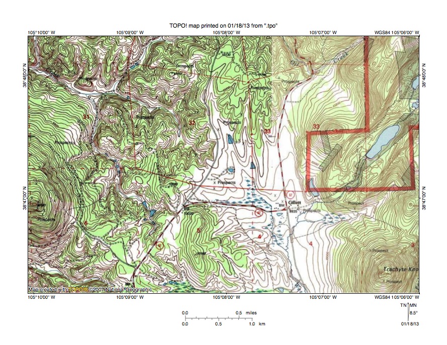
Figure 10: Detailed map of Oil Creek-West Fork Beaver Creek drainage divide area. United States Geological Survey map digitally presented using National Geographic Society TOPO software.
Figure 10 provides a detailed topographic map of the Oil Creek-West Fork Beaver Creek drainage divide area seen in less detail in figure 9. The map contour interval for figure 10 is 40 feet. Trachyte Knob is located near the southeast corner of figure 10. Rhyolite Mountain is located near the west edge of section 6 (near southwest corner of figure 10). Oil Creek flows in a southwest and north-northwest direction from the north edge of figure 10 to the north edge of figure 10 (north of section 33 in northeast quadrant of figure 10). North of figure 10 Oil Creek flows in a north-northwest direction to join south, west, south, south-southwest, and south oriented Fourmile Creek, which flows to the southeast oriented Arkansas River. Oil Creek joins Fourmile Creek near the point where Fourmile Creek turns from flowing in a south direction to flow in a west direction. West Fork Beaver Creek flows in a south-southwest direction from the east edge of figure 10 (north half) into section 4 (just south of Gillett) and then turns to flow in a south direction to the south edge of figure 10 (east half). South of figure 10 West Fork Beaver Creek flows in a south-southeast direction to south oriented Beaver Creek, which flows to the Arkansas River. The west-northwest oriented stream flowing to the west edge of figure 10 (north half-north of Rhyolite Mountain) is Barnard Creek. West of figure 10 Barnard Creek flows in a southeast direction to join south oriented Fourmile Creek. The west oriented stream on the south side of Rhyolite Mountain (in southwest corner of figure 10) is Spring Creek, which west of figure 10 flows to Barnard Creek. Rhyolite Mountain and Trachyte Knob are constructional landforms and were formed after erosion had deeply lowered the surface in this region. Headward erosion of the Barnard Creek valley and its tributary valleys around Rhyolite Mountain suggests floodwaters flowed across the region after Rhyolite Mountain had formed. Further the reversal of the flood flow that created the north-northwest oriented Oil Creek drainage route suggests floodwaters flowed between Rhyolite Mountain and Trachyte Knob after the volcanic mountains had been formed.
Additional information and sources of maps studied
This essay has provided only a sample of the detailed topographic map evidence supporting the flood erosion interpretation. Many additional illustrations could be provided. Readers are encouraged to look at mosaics of detailed topographic maps to see the abundance of available data. Maps used in this study were created and published by the United States Geologic Survey and can be obtained directly from the United States Geological Survey and/or from dealers offering United States Geological Survey maps. Hard copy maps can also be observed at United States Geological Survey map depositories, which are located throughout the United States and elsewhere. Illustrations used here were created using National Geographic Society TOPO software and digital map data. TOPO software and map data can be obtained from the National Geographic Society and/or dealers offering National Geographic Society digital map data.

Leave a comment