
Abstract:
This essay uses topographic map evidence to interpret landform origins in the South Platte River-Arkansas River drainage divide area in Park and Teller Counties, Colorado. The South Platte River in southeast Park County makes an abrupt turn from flowing in a southeast direction to flow in a northeast direction across the Puma Hills in Elevenmile Canyon and then to flow in a north and north-northeast direction into northeast Colorado where it turns to flow in a southeast and northeast direction into western Nebraska with water eventually reaching the south oriented Mississippi River. The Arkansas River originates west of the South Platte River headwaters and the flows south of the South Platte River in a south, southeast, east-northeast, and southeast direction and eventually reaches the south oriented Mississippi River. The South Platte River-Arkansas River drainage divide in Park and Teller Counties is an asymmetric drainage divide with short north oriented South Platte River tributaries and much longer south oriented Arkansas River tributaries. North-to-south oriented through valleys on both sides of Thirtynine Mile Mountain link the north oriented South Platte River tributary valleys with the south oriented Arkansas River tributary valleys. The deepest through valley is a north-to-south oriented channel east of Thirtynine Mile Mountain in a much broader north-to-south oriented through valley, which is approximately 900 meters lower in elevation than mountains on either side. The through valleys were eroded by immense south oriented floods prior to a flood flow reversal that created the present day north-northeast oriented South Platte River drainage route. Floodwaters were derived from the western margin of a thick North American ice sheet and flowed from western Canada to and across Colorado at a time when Colorado mountain ranges were beginning to emerge. Mountain ranges emerged as floodwaters flowed across them, as ice sheet related crustal warping raised Colorado and the mountain masses, and as deep valleys eroded headward into Colorado from both the east and the west. Headward erosion of the deep southeast oriented Arkansas River valley captured south oriented flood flow in Fremont County, which is south of Teller and Park Counties. Later headward erosion of a deep southeast and northeast oriented South Platte River valley into northeast Colorado beheaded south oriented flood flow routes in eastern Colorado. Floodwaters on north ends of the beheaded flood flow channels reversed flow direction to create north oriented South Platte River tributary drainage routes and the north-northeast oriented South Platte River drainage route, which captured south and southeast oriented flood flow from further to the west. Headward erosion of the deep southwest oriented Colorado River valley subsequently beheaded and reversed south and southeast oriented flood flow channels to the newly eroded south and southeast oriented Arkansas River, South Platte River, and South Platte River tributary headwaters valleys and created north and northwest oriented Colorado River tributary drainage routes.
Preface
The following interpretation of detailed topographic map evidence is one of a series of essays describing similar evidence for all major drainage divides contained within the Missouri River drainage basin and for all major drainage divides with adjacent drainage basins. The research project is interpreting evidence in the context of a previously unexplored deep glacial erosion paradigm, which is fundamentally different from most commonly accepted North American glacial history interpretations. Project essays are listed on the sidebar category list under their appropriate Missouri River tributary drainage basin, Missouri River segment drainage basin (by state), and/or state in which the Missouri River drainage basin is located.
Introduction
The purpose of this essay is to use topographic map interpretation methods to explore the South Platte River-Arkansas River drainage divide area landform origins in Park and Teller Counties, Colorado. Map interpretation methods can be used to unravel many geomorphic events leading up to formation of present-day drainage routes and development of other landform features. While each detailed topographic map feature provides detailed evidence to be explained, the solution must be consistent with explanations for adjacent area map evidence as well as solutions to big picture map evidence puzzles. I invite readers to improve upon my solutions and/or to propose alternate solutions that better explain evidence and are also consistent with adjacent map area and big-picture evidence. Readers may do so either by making comments here or by writing and publishing their own essays and then by leaving a link to those essays in a comment here.
This essay is also exploring a new geomorphology paradigm in which erosional landforms are interpreted as evidence left by immense glacial melt water floods. Implied in that interpretation is the immense floods were derived from a thick North American ice sheet that created a deep “hole” in the North American continent and also melted fast. The previously unexplored paradigm being tested in this and other Missouri River drainage basin landform origins research project essays is a thick North American ice sheet, comparable in thickness to the Antarctic ice sheet, occupied the North American region usually recognized to have been glaciated, and through its weight and erosive actions created a deep North American “hole”. The southwestern rim of that deep “hole” is today preserved in the high Rocky Mountains. The ice sheet through its weight and deep erosion (and perhaps deposition along major south-oriented melt water flow routes) caused significant crustal warping and tectonic change, through its action of melting fast produced immense floods that flowed across the continent, and through its action of melting fast systematically opened up space in the ice sheet created “hole” so headward erosion of newly developed north-oriented drainage systems captured immense south-oriented melt water floods and diverted immense melt water floods north into space the ice sheet had once occupied.
If this previously unexplored paradigm is correct the geographic region explored by this essay should contain evidence of immense floods that were captured by headward erosion of new valley systems so as to cause the floods to flow in a different direction. Ability of this previously unexplored paradigm to explain South Platte River-Arkansas River drainage divide area landform evidence in Park and Teller Counties, Colorado will be regarded as evidence supporting the “thick ice sheet that melted fast” paradigm.
South Platte River-Arkansas River drainage divide area location map
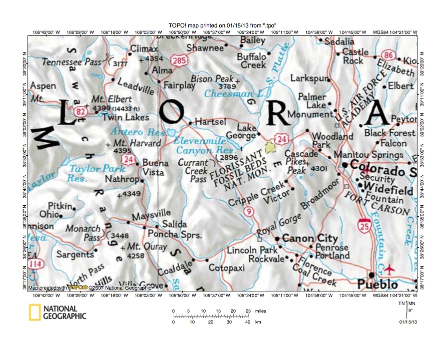
Figure 1: South Platte River-Arkansas River drainage divide area location map (select and click on maps to enlarge). National Geographic Society map digitally presented using National Geographic Society TOPO software.
Figure 1 provides a location map for the South Platte River-Arkansas River drainage divide area in Park and Teller Counties, Colorado and illustrates a region in central Colorado. Pueblo is located near the southeast corner of figure 1 and Colorado Springs is located in the east center area of figure 1. The Florissant Fossil Beds National Monument is located west of Colorado Springs and Elevenmile Canyon Reservoir is west of the Florissant Fossil Beds National Monument. The South Platte River flows in a southeast direction from Hartsel to Elevenmile Canyon Reservoir and at the southeast end of Elevenmile Canyon Reservoir makes an abrupt turn to flow in a north-northeast direction to the north edge of figure 1. North of figure 1 the South Platte River flows in a north-northeast direction into northeast Colorado where it turns in a southeast direction before turning to flow in a northeast direction to enter western Nebraska. Once in Nebraska the South Platte River joins the North Platte River to form the Nebraska Platte River, which flows to the Missouri River, which flows to the Mississippi River. Tennessee Pass is located near the northwest corner of figure 1. The Arkansas River originates on the south side of Tennessee Pass and flows in a south-southeast direction to Coaldale and then turns in an east-northeast direction before turning in an east-southeast direction to flow through Royal Gorge to Pueblo and the east edge of figure 1 (near southeast corner). East of figure 1 the Arkansas River flows in a southeast direction to eventually reach the Mississippi River. The South Platte River-Arkansas River drainage divide area investigated in this essay is located near the center of figure 1 and includes the region east of Hartsel and west of the Florissant Fossil Beds National Monument and includes Currant Creek Pass. The drainage divide is an asymmetric drainage divide with long south oriented Arkansas River tributaries and no north oriented South Platte River tributaries shown in figure 1.
Colorado drainage routes developed during immense melt water floods from the western margin of a thick North American ice sheet at a time when Colorado mountain ranges were beginning to emerge. Floodwaters flowed from western Canada to and across Colorado in a south direction as ice sheet related crustal warping raised Colorado and the regional mountain masses. Colorado mountain ranges emerged as floodwaters flowed across them and as deep valleys eroded headward into the region from both the east and the west. Headward erosion of the deep Arkansas River valley first captured south oriented flood flow in the region east of Tennessee Pass and south oriented tributary valleys eroded headward from the newly eroded Arkansas River valley. The present day north-northeast oriented South Platte River alignment north of Lake George and north oriented South Platte River tributaries seen in the northeast corner of figure 1 are located along the alignments of south oriented flood flow channels, which once flowed to the actively eroding Arkansas River valley. The southeast oriented South Platte River segment upstream from Elevenmile Canyon and southeast oriented tributaries to the present day north-northeast oriented South Platte River valley segment eroded headward from south oriented flood flow channels to the newly eroded Arkansas River valley. Ice sheet related crustal warping (and possibly related volcanic activity) raised the south end of the present day north oriented South Platte River drainage basin as headward erosion of a deep southeast and northeast oriented South Platte River valley from western Nebraska into northeast Colorado (north of figure 1) beheaded the south oriented flood flow channels on the present day north oriented South Platte River and tributary drainage routes. Floodwaters on north ends of the beheaded flood flow channels reversed flow direction to flow toward the deeper southeast and northeast oriented South Platte River valley (in northeast Colorado) and to the create the present day north oriented South Platte River and tributary drainage routes. Headward erosion of the deep southwest oriented Colorado River valley north of the northwest quadrant of figure 1 beheaded and reversed south oriented flood flow channels supplying floodwaters to the south and south-southeast oriented Arkansas River and South Platte River headwaters and to southeast oriented South Platte River tributary valleys and ended flood flow in the region seen in figure 1.
Detailed location map for South Platte River-Arkansas River drainage divide area

Figure 2: Detailed location map for South Platte River-Arkansas River drainage divide area. United States Geological Survey map digitally presented using National Geographic Society TOPO software.
Figure 2 provides a detailed location map for the South Platte River-Arkansas River drainage divide area in Park and Teller Counties, Colorado. County lines are shown and Chaffee, Teller, and Fremont County are labeled. Park County is north of Fremont County, west of Teller County, and east of Chaffee County. The Arkansas River flows in a south-southeast direction from near the northwest corner of figure 2 to the south edge of figure 2 (west of center). South of figure 2 the Arkansas River turns to flow in an east-northeast direction back into figure 2 and at Parkdale turns again in a southeast direction to Canon City and the south edge of figure 2 (near southeast corner). South and east of figure 2 the Arkansas River flows in a southeast direction and eventually reaches the Mississippi River. Hartsel is located at a highway junction near the north edge of figure 2 (slightly west of center). The South Platte River flows in a southeast direction from Hartsel to Elevenmile Canyon Reservoir and then turns to flow in a northeast direction to Lake George. From Lake George the South Platte River flows in a north direction to the north edge of figure 2 (east half). North of figure 2 the South Platte River flows in a north-northeast direction into northeast Colorado where it turns in a southeast and then northeast direction to flow into western Nebraska with water eventually reaching the Mississippi River. Thirtynine Mile Mountain is located south of Elevenmile Canyon Reservoir and is on the drainage divide between relatively short north and northeast oriented South Platte River tributaries and much longer east, southeast, south-southeast, and south oriented Arkansas River tributaries. Labeled north oriented tributaries to the southeast oriented South Platte River include Buffalo Gulch and Agate Creek. Currant Creek flows in a southeast and south-southeast direction from the south side of Thirtynine Mile Mountain to join the Arkansas River near Parkdale. West Fourmile Creek originates in the Thirtynine Mile Mountain area and flows in a southeast and east direction to join south oriented Fourmile Creek in Teller County. Fourmile Creek originates in Teller County and flows in a northwest and west direction before turning in a southwest and south direction to flow into the southwest corner of Teller County and then to continue in a south direction to join the Arkansas River near Canon City. Slater Creek is a south-southeast oriented Fourmile Creek tributary flowing across the Park-Teller County border. Twin Creek is a west and northwest oriented stream flowing north of the Florissant Fossil Beds National Monument to join the South Platte River near Lake George. The Twin Creek-Fourmile Creek drainage divide area in Teller County is included in the regions illustrated and described in this essay.
Threemile Creek-Currant Creek drainage divide area

Figure 3: Threemile Creek-Currant Creek drainage divide area. United States Geological Survey map digitally presented using National Geographic Society TOPO software.
Figure 3 provides a topographic map of Threemile Creek-Currant Creek drainage divide area. The map contour interval for figure 3 is 50 meters. Elevenmile Canyon Reservoir floods the southeast oriented South Platte River valley in the northeast corner of figure 3. Agate Creek flows in a northwest direction across the southwest corner of figure 3. West of figure 3 Agate Creek turns to flow in a north direction to join the southeast oriented South Platte River. Buffalo Gulch originates in the southwest quadrant of figure 3 and then drains in a north direction to the north edge of figure 3 (west half). North of figure 3 Buffalo Gulch drains to the southeast oriented South Platte River. Threemile Creek originates a short distance east of the Buffalo Gulch headwaters and flows in a north-northeast direction to the north center area of figure 3 and then turns to flow in a northeast direction to the north center edge of figure 3 and to join the southeast oriented South Platte River north of figure 3. Threemile Mountain is located near the center of figure 3 and on the east side of Threemile Creek. Currant Creek Pass is located south of Threemile Mountain. Currant Creek originates near Currant Creek Pass and flows in a southeast direction to the south edge of figure 3 (east of center). South of figure 3 Currant Creek turns to flow in a south-southeast direction to join the Arkansas River. The southeast oriented stream originating on the south side of Thirtynine Mile Mountain and flowing to near the southeast corner of figure 3 is West Fourmile Creek. East and south of figure 3 West Fourmile Creek flows in a southeast and east direction to join south oriented Fourmile Creek, which then flows to the Arkansas River. Currant Creek Pass is a major north-to-south oriented through valley on the west side of Thirtynine Mile Mountain and is bounded on the west by the upland containing Dicks Peak. The Currant Creek Pass elevation is between 2850 and 2900 meters. Elevations on Dicks Peak rise to 3268 meters and on Thirtynine Mile Mountain elevations rise to 3520 meters suggesting Currant Creek Pass is approximately 368 meters deep. The Currant Creek Pass through valley is a water-eroded valley and was eroded by south oriented flood flow moving to what at that time was the newly eroded Arkansas River valley (south of figure 3). At that time the deep southeast oriented South Platte River valley north of figure 3 had yet to be eroded. Headward erosion of the deep southeast oriented South Platte River valley beheaded the south oriented flood flow route to the Currant Creek valley. Floodwaters on the north end of the beheaded flood flow channel reversed flow direction to create the north oriented Threemile Creek drainage route.
Detailed map of Threemile Creek-Currant Creek drainage divide area

Figure 4: Detailed map of Threemile Creek-Currant Creek drainage divide area. United States Geological Survey map digitally presented using National Geographic Society TOPO software.
Figure 4 provides a detailed topographic map of the Threemile Creek-Currant Creek drainage divide area seen in less detail in figure 3. The map contour interval for figure 4 is 40 feet. Threemile Creek flows in a north-northeast direction from the west edge of figure 4 (south of center) to the north edge of figure 4 (west of center). North of figure 4 Threemile Creek flows in a north-northeast and northeast direction to join the southeast oriented South Platte River. Currant Creek Pass is located near the center of figure 4. Currant Creek originates near the south edge of section 12 and flows in a southwest direction to the south side of Currant Creek Pass and then flows in a south and southeast direction to the south edge of figure 4 (east half). South of figure 4 Currant Creek flows in a south-southeast direction to join the Arkansas River. Currant Creek Pass has an elevation of between 9440 and 9480 feet. Other through valleys or passes crossing the Threemile Creek-Currant Creek drainage divide are located in the southwest corner of section 12 (elevation between 9560 and 9600 feet), in the southeast corner of section 15 (elevation between 9560 and 9600 feet), and in west half of section 14 (elevation between 9600 and 9640 feet). East of these four through valleys or passes is Thirtynine Mile Mountain, which east of figure 4 rises to 11,548 feet. West of these through valleys or passes is the mountain mass containing Dicks Peak, which south of figure 4 rises 10,722 feet. Based on these elevations the four through valleys or passes are more than 1000 feet deep. These four through valleys or passes were eroded by diverging and converging south oriented flood flow channels flowing to the southeast and south-southeast oriented Currant Creek valley. The north-northeast oriented Threemile Creek headwaters (west and south of figure 4) is linked by similar north-to-south oriented through valleys with south-southeast and east oriented Thirtyone Mile Creek, which flows to south-southeast oriented Currant Creek. At the time floodwaters flowed in south directions across the region seen in figure 4 the deep southeast oriented South Platte River valley north of figure 4 did not exist. Headward erosion of the southeast oriented South Platte River valley beheaded the south oriented flood flow channels. Floodwaters on north ends of the beheaded flood flow channels reversed flow direction to create the north-northeast and northeast oriented Threemile Creek drainage route.
Ranger Station Gulch-West Fourmile Creek drainage divide area

Figure 5: Ranger Station Gulch-West Fourmile Creek drainage divide area. United States Geological Survey map digitally presented using National Geographic Society TOPO software.
Figure 5 illustrates a topographic map of the Ranger Station Gulch-West Fourmile Creek drainage divide area east and slightly south of figure 3 and includes an overlap area with figure 3. The map contour interval for figure 5 is 50 meters. The southeast end of Elevenmile Canyon Reservoir straddles the north center edge of figure 5 and floods the southeast oriented South Platte River valley. The South Platte River turns near the north center edge of figure 5 to flow in a northeast direction and north of figure 5 flows in a north-northeast direction into northeast Colorado. Thirtynine Mile Mountain is in the west center area of figure 5. Currant Creek flows in a southeast direction across the southwest corner of figure 5 and south of figure 5 flows in a south-southeast direction to eventually join the Arkansas River. West Fourmile Creek originates on the south side of Thirtynine Mile Mountain and flows in a south-southeast, east-southeast, and east direction to the southeast corner of figure 5. East of figure 5 West Fourmile Creek joins south oriented Fourmile Creek, which flows to the Arkansas River. Saddle Mountain is located east of Thirtynine Mile Mountain. A north-to-south oriented through valley or pass between Thirtynine Mile Mountain and Saddle Mountain links the north oriented Ranger Station Gulch valley with the West Fourmile Creek valley. The through valley or pass elevation is between 2900 and 2950 meters (which is slightly higher than the Currant Creek Pass elevation west of Thirtynine Mile Mountain). Thirtynine Mile Mountain rises to 3520 meters and Saddle Mountain rises to 3290 meters suggesting the through valley is approximately 340 meters deep. The southeast oriented stream originating on the east side of Saddle Mountain and joining West Fourmile Creek at the southeast corner of figure 5 is Cobb Creek. The northeast and north oriented stream originating just north of the Cobb Creek headwaters and flowing to the north edge of figure 5 (near northeast corner) is Fish Creek. North of figure 5 Fish Creek flows to northwest oriented Twin Creek, which then flows to the north-northeast oriented South Platte River. The Fish Creek-Cobb Creek drainage divide has an elevation of between 2800 and 2850 meters (which is lower than elevations of through valleys or passes to the west). A northwest-to-southeast oriented through valley north of Saddle Mountain links a north oriented Ranger Station Gulch tributary valley with the Fish Creek and Cobb Creek headwaters valleys and has an elevation of between 2900 and 2950 meters. These through valleys or passes were eroded by south and southeast oriented flood flow at a time when the deep southeast and northeast oriented South Platte River valley did not exist. Instead floodwaters flowed in south and southeast directions to the south oriented Fourmile Creek valley (east and south of figure 5). Headward erosion of the deep northeast oriented South Platte River valley across the Puma Hills created northeast oriented Elevenmile Canyon, which is downstream from the Elevenmile Canyon Reservoir Dam, and captured the southeast oriented flood flow. The deep Elevenmile Canyon knick point then eroded headward along what had been a much higher-level southeast oriented flood flow channel.
Detailed map of Ranger Station Gulch-West Fourmile Creek drainage divide area
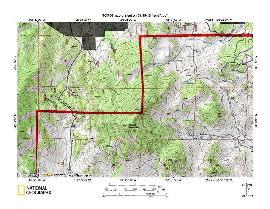
Figure 6: Detailed map of Ranger Station Gulch-West Fourmile Creek drainage divide area. United States Geological Survey map digitally presented using National Geographic Society TOPO software.
Figure 6 provides a detailed topographic map of the Ranger Station Gulch-West Fourmile Creek drainage divide area seen in less detail in figure 5. The map contour interval for figure 6 is 40 feet. Saddle Mountain located in the southeast quadrant of section 17. Ranger Station Gulch originates in section 18 (west of Saddle Mountain) and drains in a north direction to the north edge of figure 6 (west half). North of figure 6 Ranger Station Gulch drains to the South Platte River where it turns from flowing in a southeast direction to flow in a northeast direction. The south oriented stream originating in the south half of section 18 is a West Fourmile Creek tributary. Thirtynine Mile Road crosses the Ranger Gulch-West Fourmile Creek drainage divide in section 18 at an elevation of between 9480 and 9520 feet. Saddle Mountain to the east rises to 10,794 feet and Thirtynine Mile Mountain to the west of figure 6 rises much higher suggesting the pass or through valley is more than 1200 feet deep. The Ranger Station Gulch-West Fourmile Creek through valley or pass west of Saddle Mountain was eroded by south oriented flood flow, which was captured by headward erosion of the east oriented West Fourmile Creek valley (south of figure 6), which had eroded headward from the south oriented Fourmile Creek valley. Cobb Creek originates in section 16 (on east side of Saddle Mountain and flows in an east-southeast direction to the east edge of figure 6 (south half). East of figure 6 Cobb Creek turns to flow in a southeast direction to join east oriented West Fourmile Creek, which flows to south oriented Fourmile Creek, which in turn flows to the Arkansas River. Brooker Gulch (unlabeled in figure 6) drains in a northeast direction across the southeast corner of section 9 and then turns in an east and southeast direction to the east center edge of figure 6. East of figure 6 Brooker Gulch drains in a southeast direction to join Cobb Creek. Fish Creek originates in section 9 and flows in a northeast direction to the northeast corner of figure 6. North and east of figure 6 Fish Creek turns to flow in a north, east, and north direction to join northwest oriented Twin Creek, which flows to the north-northeast oriented South Platte River. The Fish Creek-Brooker Gulch drainage divide in section 10 has an elevation of between 9320 and 9360 feet and while not seen in figure 6 elevations along the Fish Creek-Fourmile Creek drainage divide decrease in an east direction. The decrease in elevations east of figure 6 suggests headward erosion of the deep south oriented Fourmile Creek valley captured significant south and southeast oriented flood flow flowing from what is today the north-northeast oriented South Platte River valley north and east of figure 6.
South Platte River-Cobb Creek drainage divide area

Figure 7: South Platte River-Cobb Creek drainage divide area. United States Geological Survey map digitally presented using National Geographic Society TOPO software.
Figure 7 illustrates the South Platte River-Cobb Creek drainage divide area east and slightly north of figure 5 and there is an overlap area with figure 5. The map contour interval for figure 7 is 50 meters. Elevenmile Canyon Reservoir floods the southeast oriented South Platte River valley in the northwest corner of figure 7 and then the South Platte River makes an abrupt turn to flow in a northeast direction through Elevenmile Canyon. Ranger Station Gulch drains in a north direction from west of Saddle Mountain to join the South Platte River at the point where the South Platte River turns in a northeast direction. Cobb Creek flows in an east-southeast and southeast direction from the east side of Saddle Mountain to the south center edge of figure 7. South of figure 7 Cobb Creek joins east oriented West Fourmile Creek, which flows to south oriented Fourmile Creek. Fourmile Creek flows in a south-southwest direction across the southeast corner of figure 7 and south of figure 4 turns to flow in a south direction to join the Arkansas River. Hay Creek flows in a west and south-southwest direction from the east center edge of figure 7 to join Fourmile Creek near the southeast corner of figure 7. Fish Creek originates near the north side of Saddle Mountain and flows in a northeast, north, east, and north direction to the north edge of figure 7 (east of center) and north of figure 7 joins northwest oriented Twin Creek, which flows to the north-northeast oriented South Platte River. Grape Creek flows in west and north-northwest direction from the east edge of figure 7 (north of center) through the Florissant Fossil Beds National Monument to the north edge of figure 7 (east half) and north of figure 7 joins northwest oriented Twin Creek. The Grape Creek-Fourmile Creek drainage divide south of the Florissant Fossil Beds National Monument has an elevation of 2615 meters compared with an elevation of more than 2900 meters on the South Platte River-Cobb Creek drainage divide north of Saddle Mountain. Yet the southeast oriented South Platte River valley is on the same alignment as the southeast oriented Cobb Creek valley suggesting that at one time southeast oriented flood flow on the South Platte River alignment flowed to the southeast oriented Cobb Creek valley, which then drained to the much deeper south oriented Fourmile Creek valley. What is intriguing is the deep south oriented Fourmile Creek valley is not located south of the present day South Platte River elbow of capture, but is located south of the northeast end of Elevenmile Canyon. This evidence suggests Elevenmile Canyon eroded headward across a drainage divide between a south oriented flood flow channel on the south oriented Fourmile Creek and north-northeast oriented South Platte River alignment (north of Elevenmile Canyon) and a southeast oriented flood flow channel on the southeast oriented South Platte River and Cobb Creek alignment. This concept is explored further in the figure 8 discussion.
South Platte River-Fish Creek south drainage divide area
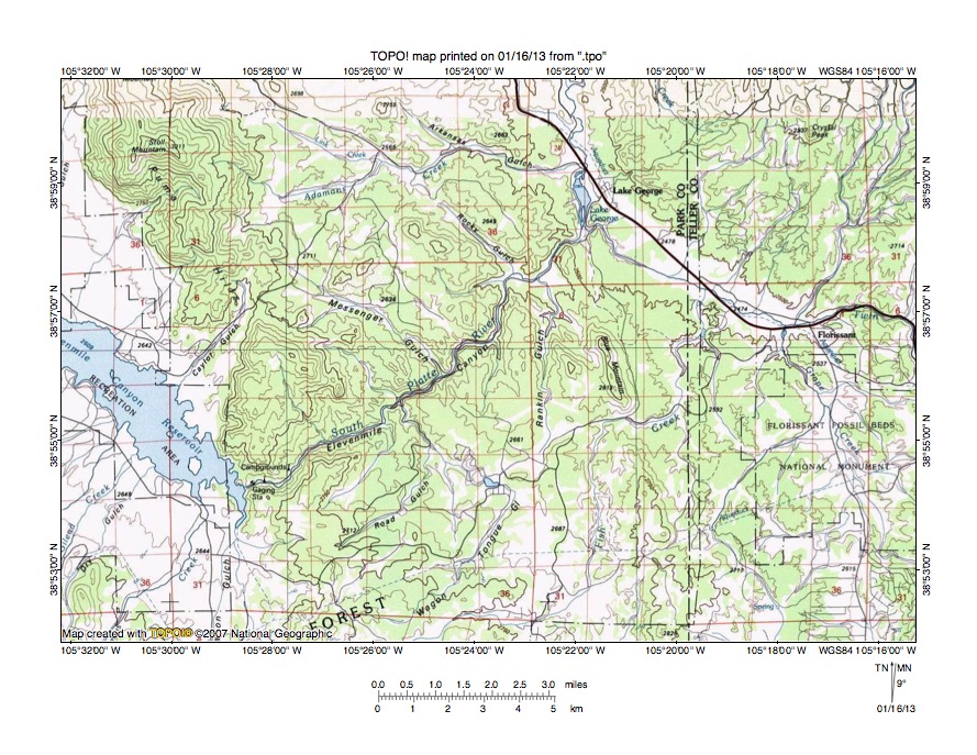
Figure 8: South Platte River-Fish Creek drainage divide area. United States Geological Survey map digitally presented using National Geographic Society TOPO software.
Figure 8 provides a topographic map of the South Platte River-Fish Creek drainage divide north and slightly west of figure 7. The map contour interval for figure 8 is 50 meters. The South Platte River flows in a northeast direction from the southeast end of Elevenmile Canyon Reservoir through Elevenmile Canyon to Lake George and then flows in a north direction to the north edge of figure 8. (east of center). North of figure 8 the South Platte River flows in a north-northeast direction into northeast Colorado where it turns to flow in a southeast and then northeast direction to western Nebraska. The Puma Hills are the northwest-to-southeast oriented upland region extending from near the northwest corner of figure 8 to and beyond Elevenmile Canyon. Several southeast oriented drainage routes flow from the Puma Hills to join the northeast oriented South Platte River in Elevenmile Canyon while several northwest and north oriented drainage routes flow to the northeast oriented South Platte River from the southeast. The southeast and northwest oriented drainage routes suggest the deep northeast oriented Elevenmile Canyon valley was eroded headward across southeast oriented flood flow, which at one time flowed across the Puma Hills. The northwest and north oriented tributaries were created by reversals of flood flow on northwest and north ends of beheaded flood flow channels. One of the major flood flow channels was beheaded near Lake George and is today the northwest oriented Twin Creek drainage route between Florissant and Lake George and the north oriented Grape Creek drainage route south of Florissant. Before being beheaded and reversed to create the north oriented Grape Creek and northwest oriented Twin Creek drainage routes floodwaters flowed in a south direction on the present day north oriented South Platte River alignment north of Lake George and then in a southeast direction on the present day northwest oriented Twin Creek alignment to near Florissant before flowing in a south direction on the present day north oriented Grape Creek alignment to the what was at that time the actively eroding south oriented Hay Creek and Fourmile Creek valley. Before headward erosion of the deep northeast oriented Elevenmile Canyon valley the Puma Hills may have been emerging as a barrier between a deep south, southeast, and south oriented flood flow channel flowing from the present day north and north-northeast South Platte River alignment north of Lake George and a converging and much higher elevation southeast oriented flood flow channel on the present southeast oriented South Platte River and Cobb Creek alignments with the two flood flow channels converging south of figures 8 and 7. Headward erosion of the deep northeast oriented Elevenmile Canyon valley captured the southeast oriented flood flow channel on the present day southeast oriented South Platte River alignment and the much deeper valley knick point then eroded headward along that southeast oriented flood flow channel to create a much lower base level for what is today the South Park Basin (upstream in the South Platte River drainage basin). South oriented flood flow on the present day north-northeast oriented South Platte River alignment was beheaded and reversed by headward erosion of the deep southeast and northeast oriented South Platte River valley from western Nebraska into northeast Colorado (north of figure 8). The reversed flood flow channel captured significant flood flow from the west, but ended south oriented flood flow to the south oriented Fourmile Creek valley. The reversal of flood flow was probably aided by ice sheet related crustal warping and possibly volcanic activity that raised elevations in the South Platte River-Fourmile Creek drainage divide region.
Grape Creek-Fourmile Creek drainage divide area

Figure 9: Grape Creek-Fourmile Creek drainage divide area. United States Geological Survey map digitally presented using National Geographic Society TOPO software.
Figure 9 illustrates the Grape Creek-Fourmile Creek drainage divide area east and slightly north of figure 7 and there is an overlap area with figure 7. The map contour interval for figure 9 is 50 meters. The South Platte River flows in a northeast direction in Elevenmile Canyon across the northwest corner of figure 9. North of figure 9 the South Platte River turns to flow in a north and north-northeast direction into northeast Colorado and then to flow in a southeast and northeast direction into western Nebraska. Florissant is a town near the north center edge of figure 9 and the Florissant Fossil Beds National Monument is south of Florissant. Divide is a town near the northeast corner of figure 9. The north-northeast oriented stream flowing to the northeast corner of figure 9 is Rule Creek, North and east of figure 9 Rule Creek joins north and north-northwest oriented Trout Creek, which eventually reaches the north-northeast oriented South Platte River. Twin Creek originates south of Divide and flows in a northeast and north direction before turning to flow in a west direction to Florissant. From Florissant Twin Creek flows in a northwest direction to join the north and north-northeast oriented South Platte River. Grape Creek flows in a north and north-northwest direction from near the center of figure 9 through the Florissant Fossil Beds National Monument to join Twin Creek near Florissant. Fourmile Creek flows in an east and south direction from the east edge of figure 9 (north of center) to Midland. From Midland Fourmile Creek flows in a south, west, and southwest direction to the south center edge of figure 9. South of figure 9 Fourmile Creek flows in a south direction to reach the Arkansas River. Hay Creek is a southwest and south-southwest oriented tributary joining Fourmile Creek near the south center edge of figure 9. The Grape Creek-Hay Creek drainage divide south of the Florissant Fossil Beds National Monument has an elevation of 2615 meters. Elevations in the Tracy Hill area east of the Grape Creek-Hay Creek through valley reach 2880 meters and Pikes Peak in the Rampart Range is located east of figure 9 with elevations exceeding 4300 meters. As seen in earlier figures elevations on Thirtynine Mile Mountain to the west reach 3520 meters. These elevations suggest there is a broad north-to-south oriented through valley between Thirtynine Mile Mountain and the Rampart Range, which is up to 900 meters deep. The north end of the through valley is drained today by the north-northeast oriented South Platte River while the south end of the through valley is drained by south oriented Fourmile Creek and other south oriented Arkansas River tributaries. This giant north-t0-south oriented through valley was eroded by massive amounts of south oriented flood flow prior to the reversal of flood flow that created the north-northeast oriented South Platte River drainage route. Crustal warping that was raising the present day South Platte River-Arkansas River drainage divide area probably played a significant role in the flood flow reversal, although the flood flow reversal was triggered by headward erosion of the deep southeast and northeast oriented South Platte River valley from western Nebraska into northeast Colorado where it beheaded and reversed south oriented flood flow channels on the Colorado Piedmont to create north oriented South Platte River tributary drainage routes and the north-northeast oriented South Platte River drainage route.
Detailed map of Grape Creek-Hay Creek drainage divide area

Figure 10: Detailed map of Grape Creek-Hay Creek drainage divide area. United States Geological Survey map digitally presented using National Geographic Society TOPO software.
Figure 10 provides a detailed topographic map of the Grape Creek-Hay Creek drainage divide area seen in less detail in figure 9. The map contour interval for figure 10 is 40 feet. The dashed lines seen in the north half of figure 10 are boundary lines for the Florissant Fossil Beds National Monument, the southern area of which is seen in figure 10. The north oriented streams flowing to the north center edge of figure 10 are tributaries to north oriented Grape Creek, which flows to northwest oriented Twin Creek, which flows to the north and north-northeast oriented South Platte River. Hay Creek flows in a southwest direction across the southeast corner of figure 10. South of figure 10 Hay Creek flows to south oriented Fourmile Creek, which flows to the Arkansas River. Other south oriented streams flowing to the south edge of figure 10 are Hay Creek or Fourmile Creek tributaries. The road extending from the north center edge of figure 10 to the south center edge of figure 10 is located in a north-to-south oriented through valley linking the north oriented Grape Creek valley with the south oriented Hay Creek and Fourmile Creek valley. The drainage divide in the through valley is located in the southeast corner of section 25 and northeast corner of section 36 and has an elevation of between 8560 and 8600 feet. Elevations west and east of the through valley and seen in figure 10 rise to more than 8900 feet suggesting the through valley is at least 300 feet deep. However, as described in the figure 9 discussion, the through valley walls are really the Rampart Range to east and Thirtynine Mile Mountain to the west. Elevations in the Rampart Range rise to 14,170 feet at Pikes Peak and elevations on Thirtynine Mile Mountain rise to 11,548 feet. Based on the more distance valley wall elevations the through valley channel seen in figure 10 is more than 2900 feet deep. This huge north-to-south oriented through valley was at least to some extent eroded by massive south oriented flood flow prior to the reversal of flood flow that created the north-northeast oriented South Platte River drainage route. The removal of up to 2900 feet of bedrock material probably caused crustal warping that raised the drainage divide area and may even have triggered volcanic activity, although the topographic map evidence is not adequate to determine such. Today this is the deepest channel on the floor of a large north-to-south oriented through valley linking the present day north-northeast oriented South Platte River with the southeast oriented Arkansas River. However, the through valley size and depth suggests that prior to headward erosion of the Arkansas River valley large volumes of floodwaters flowed across the region in a south direction perhaps to the Rio Grande River valley.
Additional information and sources of maps studied
This essay has provided only a sample of the detailed topographic map evidence supporting the flood erosion interpretation. Many additional illustrations could be provided. Readers are encouraged to look at mosaics of detailed topographic maps to see the abundance of available data. Maps used in this study were created and published by the United States Geologic Survey and can be obtained directly from the United States Geological Survey and/or from dealers offering United States Geological Survey maps. Hard copy maps can also be observed at United States Geological Survey map depositories, which are located throughout the United States and elsewhere. Illustrations used here were created using National Geographic Society TOPO software and digital map data. TOPO software and map data can be obtained from the National Geographic Society and/or dealers offering National Geographic Society digital map data.

Leave a comment