
Abstract:
This essay uses topographic map evidence to interpret landform origins in the North Fork South Platte River-Tarryall Creek drainage divide area in Park County, Colorado. The North Fork South Platte River originates near the east-west continental divide and flows in a southeast, east, northeast, and southeast direction to join the north-northeast oriented South Platte River. Tarryall Creek originates near the continental divide south and west of the North Fork South Platte River headwaters and then flows in a southeast direction to join the north-northeast oriented South Platte River as a barbed tributary. Between the North Fork South Platte River and Tarryall Creek are the northwest-to-southeast oriented Kenosha and Tarryall Mountains. A deep north-to-south oriented through valley (Kenosha Pass) at the west end of the Kenosha Mountains links the North Fork South Platte River valley with the southeast oriented Tarryall Creek valley. Other through valleys or passes are common throughout the North Fork South Platte River-Tarryall Creek drainage divide area and can be found crossing drainage divides at all elevations. Barbed tributaries and elbows of capture are common with most drainage routes flowing for significant distances in southeast directions before joining the north oriented South Platte River. These and other landform features are illustrated on topographic maps and then described and interpreted in the context of immense south oriented melt water floods from the western margin of a thick North American ice sheet. Floodwaters flowed from western Canada to and across Colorado at a time when Colorado mountain ranges were beginning to emerge. Colorado mountain ranges emerged as floodwaters flowed across them, as ice sheet related crustal warping raised Colorado and the mountain masses and as deep valleys eroded headward into Colorado from both the east and the west. The present day north-northeast oriented South Platte River alignment originated as south oriented flood flow channels flowing to what at that time was probably the newly eroded southeast oriented Arkansas River valley. The southeast oriented Tarryall Creek, North Fork South Platte River, and other South Platte River tributary valleys eroded headward from those south oriented flood flow channels (in sequence from south to north) to capture south oriented flood flow in the emerging mountains west or the present day South Platte River drainage route (for example, headward erosion of the North Fork South Platte River beheaded south oriented flood flow to the newly eroded Tarryall Creek valley west of Kenosha Mountain to create Kenosha Pass). Headward erosion of the deep southeast and northeast oriented South Platte River valley into northeast Colorado from western Nebraska at some point in time beheaded south oriented flood flow channels on the South Platte River alignment. Floodwaters on north ends of the beheaded flood flow channels reversed flow direction to flow to the deeper southeast and northeast oriented South Platte River valley and to create the north-northeast oriented South Platte River drainage route seen today. Crustal warping that was raising the Park County, Colorado area probably contributed significantly to the flood flow reversal.
Preface
The following interpretation of detailed topographic map evidence is one of a series of essays describing similar evidence for all major drainage divides contained within the Missouri River drainage basin and for all major drainage divides with adjacent drainage basins. The research project is interpreting evidence in the context of a previously unexplored deep glacial erosion paradigm, which is fundamentally different from most commonly accepted North American glacial history interpretations. Project essays are listed on the sidebar category list under their appropriate Missouri River tributary drainage basin, Missouri River segment drainage basin (by state), and/or state in which the Missouri River drainage basin is located.
Introduction
The purpose of this essay is to use topographic map interpretation methods to explore the North Fork South Platte River-Tarryall Creek drainage divide area landform origins in Park County, Colorado. Map interpretation methods can be used to unravel many geomorphic events leading up to formation of present-day drainage routes and development of other landform features. While each detailed topographic map feature provides detailed evidence to be explained, the solution must be consistent with explanations for adjacent area map evidence as well as solutions to big picture map evidence puzzles. I invite readers to improve upon my solutions and/or to propose alternate solutions that better explain evidence and are also consistent with adjacent map area and big-picture evidence. Readers may do so either by making comments here or by writing and publishing their own essays and then by leaving a link to those essays in a comment here.
This essay is also exploring a new geomorphology paradigm in which erosional landforms are interpreted as evidence left by immense glacial melt water floods. Implied in that interpretation is the immense floods were derived from a thick North American ice sheet that created a deep “hole” in the North American continent and also melted fast. The previously unexplored paradigm being tested in this and other Missouri River drainage basin landform origins research project essays is a thick North American ice sheet, comparable in thickness to the Antarctic ice sheet, occupied the North American region usually recognized to have been glaciated, and through its weight and erosive actions created a deep North American “hole”. The southwestern rim of that deep “hole” is today preserved in the high Rocky Mountains. The ice sheet through its weight and deep erosion (and perhaps deposition along major south-oriented melt water flow routes) caused significant crustal warping and tectonic change, through its action of melting fast produced immense floods that flowed across the continent, and through its action of melting fast systematically opened up space in the ice sheet created “hole” so headward erosion of newly developed north-oriented drainage systems captured immense south-oriented melt water floods and diverted immense melt water floods north into space the ice sheet had once occupied.
If this previously unexplored paradigm is correct the geographic region explored by this essay should contain evidence of immense floods that were captured by headward erosion of new valley systems so as to cause the floods to flow in a different direction. Ability of this previously unexplored paradigm to explain North Fork South Platte River-Tarryall Creek drainage divide area landform evidence in Park County, Colorado will be regarded as evidence supporting the “thick ice sheet that melted fast” paradigm.
North Fork South Platte River-Tarryall Creek drainage divide area location map
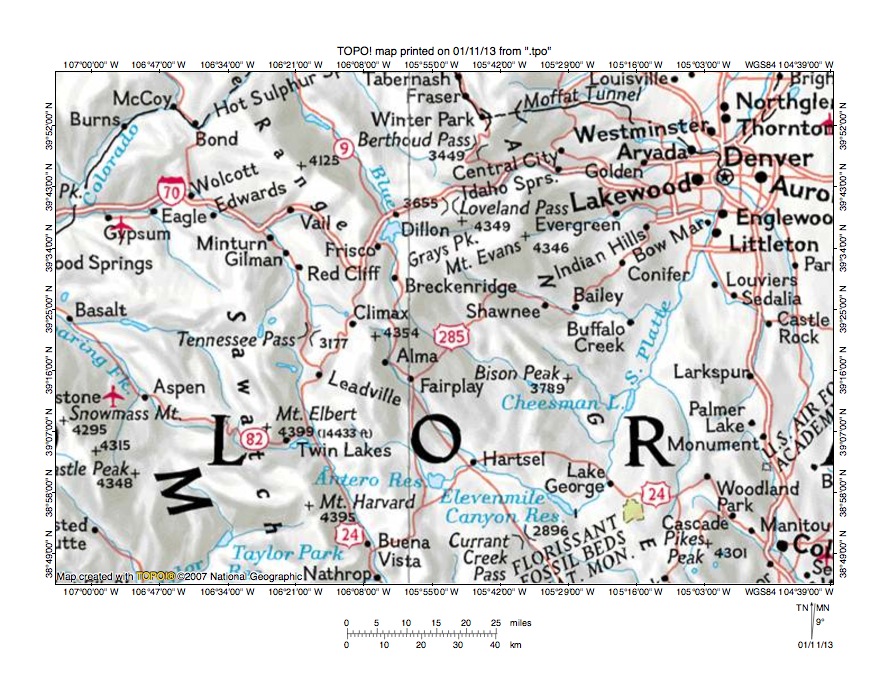
Figure 1: North Fork South Platte River-Tarryall Creek drainage divide area location map (select and click on maps to enlarge). National Geographic Society map digitally presented using National Geographic Society TOPO software.
Figure 1 provides a location map for the North Fork South Platte River-Tarryall Creek drainage divide area in Park County, Colorado and illustrates a region in central Colorado. Denver is located near the northeast corner of figure 1 and Colorado Springs is located near the southeast corner of figure 1. Elevenmile Canyon Reservoir is located west of Colorado Springs. The South Platte River flows in southeast direction from Hartsel to Elevenmile Canyon Reservoir and abruptly turns to flow in a north-northeast direction to Denver and the north edge of figure 1 (near northeast corner). North of figure 1 the South Platte River flows in a north and northeast direction before making another turn to flow in a southeast and northeast direction to join the Nebraska Platte River in western Nebraska with water eventually reaching the Mississippi River and the Gulf of Mexico. The south and southeast oriented South Platte River tributary north of Hartsel flowing through or near Alma and Fairplay is the Middle Fork South Platte River. The South Fork South Platte River flows through Antero Reservoir. Several unlabeled southeast oriented tributaries to the north-northeast oriented South Platte River are shown in figure 1 and join the South Platte River as barbed tributaries. The southeast oriented tributary flowing on the south side of Bison Peak is Tarryall Creek. The southeast and northeast oriented tributary joining the South Platte River near Cheeseman Lake is Goose Creek and the tributary flowing through or near the towns of Shawnee, Bailey, and Buffalo Creek is the North Fork South Platte River. The south-southeast oriented river flowing from Tennessee Pass to Buena Vista and Nathrop (near south center edge of figure 1) is the Arkansas River with water eventually reaching the Mississippi River and the Gulf of Mexico. The Colorado River flows in a primarily southwest direction across the northwest corner of figure 1 and eventually reaches the Pacific Ocean. The Blue River originates north of the south oriented Middle Fork South Platte River headwaters (between Breckenridge and Alma) and flows in a north direction to Dillon Reservoir and then in a north-northwest direction to the north edge of figure 1 (west half) and north of figure 1 joins the Colorado River as a barbed tributary. The North Fork South Platte River-Tarryall Creek drainage divide area investigated in this essay is located south of the North Fork South Platte River, north of Tarryall Creek, west of the South Platte River, and east of the east-west continental divide.
Colorado drainage routes developed during immense melt water floods from the western margin of a thick North American ice sheet. Floodwaters flowed from western Canada to and across Colorado at a time when Colorado mountain ranges were beginning to emerge. Colorado mountain ranges emerged as floodwaters flowed across them, as ice sheet related crustal warping raised Colorado and the mountain masses, and as deep valleys eroded headward into Colorado from the Gulf of Mexico in the east and from the Pacific Ocean in the west. Initially floodwaters flowed in south directions, although flood flow directions changed as Colorado and mountain masses were raised and as headward erosion of deep valleys captured the south oriented flood flow. Floodwaters on north ends of beheaded flood flow channels often reversed flow direction to flow in north directions to deeper beheading valleys and to create north oriented drainage routes. The north-northeast oriented South Platte River drainage route seen in figure 1 originated as a south oriented flood flow channel (or channels) with water flowing to the southeast oriented Arkansas River valley south of figure 1. The southeast oriented South Platte River headwaters and tributaries are flowing in southeast oriented valleys, which eroded headward from the south oriented flood flow channel(s) on the present day north-northeast oriented South Platte River alignment. Headward erosion of the deep southwest oriented Colorado River valley beheaded and reversed south oriented flood flow channels leading to the south and southeast oriented South Platte River headwaters and tributary valleys. Floodwaters on the north ends of beheaded flood flow channels reversed flow direction to flow to the much deeper Colorado River valley and to create the north and north-northwest oriented Blue River drainage system. About the same time as the Colorado River valley was beheading and reversing flood flow channels headward erosion of the deep southeast and northeast oriented South Platte River valley (north of figure 1) beheaded and reversed south oriented flood flow channels on the Colorado Piedmont to create the north oriented South Platte River drainage route and its north oriented tributary drainage routes. The reversal of flood flow on the South Platte River alignment also captured flow from the southeast oriented valleys, which had eroded headward from south oriented flood flow channels leading to the southeast oriented Arkansas River valley. Capture of these southeast oriented flow routes created barbed tributaries seen today.
Detailed location map for North Fork South Platte River-Tarryall Creek drainage divide area
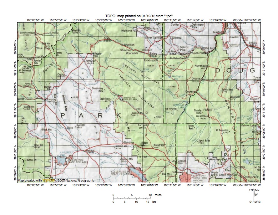
Figure 2: Detailed location map of North Fork South Platte River-Tarryall Creek drainage divide area. United States Geological Survey map digitally presented using National Geographic Society TOPO software.
Figure 2 provides a detailed location map for the North Fork South Platte River-Tarryall Creek drainage divide area in Park County, Colorado. Green colored areas are National Forest lands, which in Colorado are usually located in mountain regions. County lines are shown and Park County is labeled. Douglas County is east of Park County except in the southeast corner of figure 1 where Teller County is east of Park County. Summit County is located north and west of the Park County northwest border (in northwest corner of figure 2) and the Summit County-Park County line follows the east-west continental divide, which then extends across the northwest corner of figure 2 (north half). Hoosier Pass crosses the continental divide near the west edge of figure 2. Elevenmile Canyon Reservoir is located near the south center edge of figure 2. The Middle Fork South Platte River flows in a south and southeast direction from Hoosier Pass to Hartsel, where it joins the South Fork South Platte River to form the southeast oriented South Platte River, which then flows to Elevenmile Canyon Reservoir. At the southeast end of Elevenmile Canyon Reservoir the South Platte River makes an abrupt turn to flow in a north-northeast direction to the north edge of figure 2 (near northeast corner). Tarryall Creek originates along the continental divide (near Boreas Mountain) and flows in a southeast direction south and west of the Tarryall Mountains through the Tarryall Reservoir State Recreation Area to join the north-northeast oriented South Platte River near the Park-Teller County line. Michigan Creek is a southeast oriented Tarryall Creek tributary originating near the continental divide (north and east of Boreas Mountain) and Jefferson Creek is a southeast oriented Michigan Creek tributary. The unlabeled south oriented stream flowing from Kenosha Pass to Jefferson Creek is Snyder Creek and Rock Creek is a south oriented Tarryall Creek tributary located east of Snyder Creek. The unlabeled southeast oriented stream with two forks flowing between the Kenosha Mountains and the Tarryall Mountains is Lost Creek, which flows to southeast and northeast oriented Goose Creek, which then flows to the South Platte River at the north end of Cheeseman Reservoir. Wigwam Creek is the southeast and east oriented South Platte River tributary north of Goose Creek. The North Fork South Platte River originates along the continental divide near Whale Peak (near north edge of figure 2) and flows in a southeast direction to Grant and Estabrook before turning in more of an east direction to flow to Buffalo Creek and then in a northeast and southeast direction to join the north-northeast oriented South Platte River at the town of South Platte. Craig Creek is a southeast, northeast, and north oriented tributary joining the North Fork South Platte River at Estabrook. Buffalo Creek is a northeast oriented tributary joining the North Fork South Platte River near the town of Buffalo Creek. Before leaving figure 2 note how most drainage routes in Park County (with the exception of the north-northeast oriented South Platte River) flow in southeast directions.
North Fork South Platte River-Jefferson Creek drainage divide area
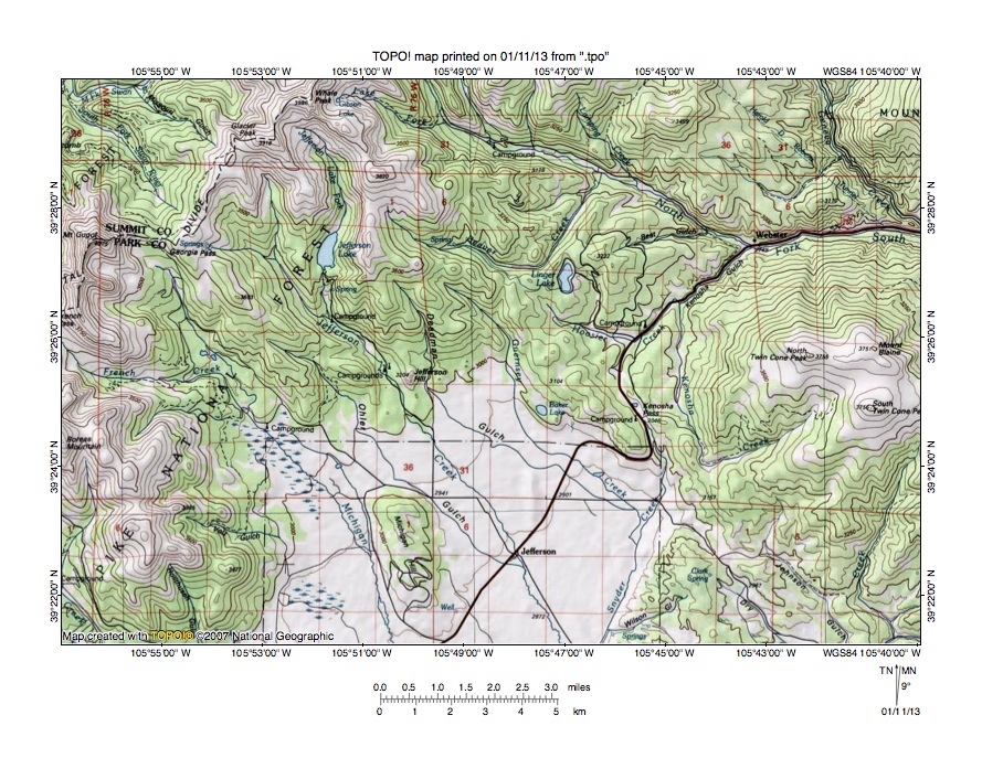
Figure 3: North Fork South Platte River-Jefferson Creek drainage divide area. United States Geological Survey map digitally presented using National Geographic Society TOPO software.
Figure 3 provides a topographic map of North Fork South Platte River-Jefferson Creek drainage divide area. The map contour interval for figure 3 is 50 meters. The Summit-Park County line follows the east-west continental divide and extends from the north edge of figure 3 (near Whale Peak-west half) to French Pass along the west edge of figure 3 (north of center). Georgia Pass is a deep gap or through valley crossing the continental divide. Michigan Creek originates on the south side of Georgia Pass and flows in a southeast and south-southeast direction to the south edge of figure 3 (west of center). South of figure 3 Michigan Creek flows to southeast oriented Tarryall Creek, which then flows to the north-northeast oriented South Platte River with water eventually reaching the Gulf of Mexico. The South Fork Swan River flows in a northwest direction from Georgia Pass to the northwest corner of figure 3. North and west of figure 3 the South Fork Swan River joins the north, northwest, and west oriented Swan River, which flows to the north and north-northwest oriented Blue River, which flows to the southwest oriented Colorado River with water eventually reaching the Pacific Ocean. Georgia Pass is more than 400 meters deep and was eroded by southeast oriented flood flow moving from the present day north oriented Blue River and Swan River alignments to the southeast oriented Tarryall Creek valley. Jefferson Lake is located south of Whale Peak and east of Georgia Pass. Jefferson Creek originates near the continental divide in the Jefferson Lake region and flows in a south-southeast direction through the town of Jefferson to the south center edge of figure 3. South of figure 3 Jefferson Creek joins southeast oriented Michigan Creek, which then flows to southeast oriented Tarryall Creek. The North Fork South Platte River originates near Whale Peak and flows in a southeast direction to Webster and then in an east direction to the east edge of figure 3 (north half). The North Fork South Platte River valley near the east edge of figure 3 is more than 1000 meters deep. The highway between Jefferson and Webster crosses the North Fork South Platte River-Jefferson Creek (Tarryall Creek) drainage divide at Kenosha Pass. Snyder Creek is the south oriented Jefferson Creek tributary flowing from the south side of Kenosha Pass. Hoosier Creek flows in a northeast direction from the north side of Kenosha Pass to north and northeast oriented Kenosha Creek, which joins the North Fork South Platte River at Webster. Kenosha Pass has an elevation of 3046 meters. North Twin Cone to the east rises to 3755 meters and Whale Peak to the west rises to 3986 meters suggesting Kenosha Pass is more than 700 meters deep. To some extent Kenosha is a water-eroded valley between high mountains on either side and was eroded by south oriented floodwaters flowing to the southeast oriented Tarryall Creek valley prior to headward erosion of the deeper North Fork South Platte River valley. South oriented floodwaters probably eroded a deeper and deeper valley into the rising mountain masses to create the deep Kenosha Pass through valley, although probably a diverging flood flow channel also eroded a deeper and deeper North Fork South Platte River valley at the same time. Headward erosion of the deeper North Fork South Platte River valley ended the south oriented flood flow to Tarryall Creek and may have occurred when flood flow on the South Platte River alignment was beheaded and reversed to create the north-northeast oriented South Platte River drainage route.
Detailed map of Kenosha Creek-Snyder Creek drainage divide area
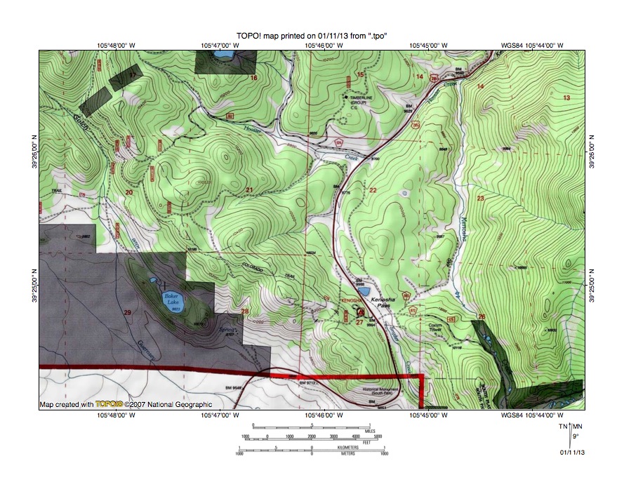
Figure 4: Detailed map of Kenosha Creek-Snyder Creek drainage divide area. United States Geological Survey map digitally presented using National Geographic Society TOPO software.
Figure 4 provides a detailed topographic map of the Kenosha Creek-Snyder Creek drainage divide area seen in less detail in figure 5. The map contour interval for figure 4 is 40 feet. Kenosha Pass is located in section 27 in the southeast quadrant of figure 4. Snyder Creek originates on the south side of Kenosha Pass and flows in a south direction to the south edge of figure 4. South of figure 4 Snyder Creek flows to southeast oriented Jefferson Creek, which flows to southeast oriented Michigan Creek, which flows to southeast oriented Tarryall Creek, which flows to the north-northeast oriented South Platte River. Kenosha Creek flows in a north direction from the south edge of figure 4 (near southeast corner) through sections 26, 23, and 14 to the north edge of figure 4. North of figure 4 Kenosha Creek flows to the east, southeast, east, northeast, and southeast oriented North Fork South Platte River, which flows to the north-northeast oriented South Platte River. Hoosier Creek flows in a southeast, east and northeast direction in the north center area of figure 4 to join Kenosha Creek in section 14. Kenosha Pass has an elevation 0f 9988 feet. North Twin Cone Peak just east of figure 4 rises to 12,323 feet and peaks along the continental divide to the west of figure 4 rise to elevations greater than 13,000 feet suggesting Kenosha Pass is more than 2300 feet deep. Kenosha Pass is a major north-to-south oriented through valley linking the east and southeast oriented North Fork South Platte River valley with the southeast oriented Tarryall Creek valley. As seen in figure 3 the North Fork South Platte River valley north and east of figure is also a large and deep east and southeast oriented valley suggesting both valleys were eroded by diverging south and southeast oriented flood flow channels, which were moving large volumes of floodwaters across the region as the surrounding mountain mass was being uplifted. At that time the present day north oriented Kenosha Creek drainage route seen in figure 4 was a south oriented flood flow channel while another south oriented flood flow channel was located on the Kenosha Pass-Snyder Creek alignment. In time headward erosion of a deeper valley on the North Fork South Platte River alignment beheaded and reversed the south oriented flood flow channels to the Tarryall Creek valley and created the north oriented Kenosha Creek drainage route and captured the southeast oriented Hoosier Creek headwaters seen in figure 4.
North Fork South Platte River-Rock Creek drainage divide area

Figure 5: North Fork South Platte River-Rock Creek drainage divide area. United States Geological Survey map digitally presented using National Geographic Society TOPO software.
Figure 5 illustrates the North Fork South Platte River-Rock Creek drainage divide area east and south of figure 3 and there is an overlap area with figure 3. The map contour interval for figure 5 is 50 meters. The Platte River Mountains and Kenosha Mountains extend in a northwest to southeast direction across figure 5. The North Fork South Platte River flows in a southeast direction from the north center edge of figure 5 to the east edge of figure 5 (north of center). East of figure 5 The North Fork South Platte River flows in more of an east direction before turning in a northeast and then southeast direction to join the north-northeast oriented South Platte River. The North Fork South Platte River valley is more than 1200 meters deep in the stretch upstream from Glenisle. Craig Creek flows in a southeast direction between the Platte River Mountains and the Kenosha Mountains before turning in a northeast direction to flow to the east edge of figure 5 (south of center). East of figure 5 Craig Creek flows to the North Fork South Platte River. The southeast oriented Craig Creek valley appears to be located along the crest of what might be breached anticlinal, which suggests elevation differences seen in figure 5 are probably the combined result of deep erosion and the uplift of underlying geologic structures. However, all valleys seen in figure 5, including the southeast oriented Craig Creek valley, are at least to some extent water-eroded valleys. The south oriented stream originating near South Twin Cone Peak and flowing to the south edge of figure 5 (near southwest corner) is Rock Creek. South of figure 5 Rock Creek flows to southeast oriented Tarryall Creek, which flows to the north-northeast oriented South Platte River. Long Gulch is a northwest oriented Rock Creek tributary draining along the southwest side of the Kenosha Mountains. Southeast oriented North and South Forks of Lost Creek can be seen flowing from the south center area of figure 5 to the south edge of figure 5 (east of center). South and east of figure 5 Lost Creek flows in a southeast direction in a valley linked with the southeast, north, and northeast oriented Goose Creek valley, which drains to the South Platte River. Long Gulch is linked by northwest-to-southeast oriented through valley with the southeast oriented South Fork Lost Creek valley. The Long Gulch-South Fork Lost Creek through valley floor elevation is between 3250 and 3300 meters. North Tarryall Peak to the south rises to 3678 meters suggesting the through valley is approximately 350 meters deep. The through valley orientation is probably determined by the regional geologic structure, but the through valley is a water-eroded valley and was eroded by southeast oriented flood flow prior to headward erosion of the deeper south oriented Rock Creek valley. Headward erosion of the deep south oriented Rock Creek valley from what at that time was the actively eroding southeast oriented Tarryall Creek valley captured the southeast oriented flood flow channel. Floodwaters on the northwest end of the beheaded flood flow channel reversed flow direction to create the northwest and southwest oriented Long Gulch drainage route. A through valley near the southeast corner of figure 5 links the southeast and south oriented North Fork Lost Creek valley with the southeast and northeast oriented Craig Creek valley. The through valley floor elevation is between 3150 and 3200 meters. Windy Peak at the southeast corner of figure 5 rises to 3648 meters while the Kenosha Mountains to the northwest rise to more than 3700 meters suggesting the through valley is approximately 450 meters deep. The through valley orientation may be determined by underlying geologic structures, but the through valley is a water-eroded feature and may have a complex history. It was probably initiated as a south oriented flood flow channel, but later may have been beheaded and reversed to flow to what at that time was the actively eroding North Fork South Platte River valley with the reversed flood flow route capturing some of the southeast oriented flood flow from the North Fork Lost Creek valley. Headward erosion of a deeper southeast oriented valley on the North Fork Lost Creek alignment then beheaded the northeast oriented flood flow channel. These diverging and converging flood flow channels were probably changing as time passed.
Detailed map of Long Gulch-South Fork Lost Creek drainage divide area
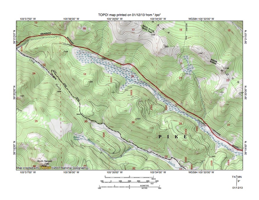
Figure 6: Detailed map of Long Gulch-South Fork Lost Creek drainage divide area. United States Geological Survey map digitally presented using National Geographic Society TOPO software.
Figure 6 provides a detailed topographic map of the Long Gulch-South Fork Lost Creek drainage divide area seen in less detail in figure 5. The map contour interval for figure 6 is 40 feet. Long Gulch originates in the southwest corner of section 19 and drains in a northwest direction to the west edge of figure 6 (north half). West of figure 6 Long Gulch drains to south oriented Rock Creek, which flows to southeast oriented Tarryall Creek, which flows to the north-northeast oriented South Platte River. South Fork Lost Creek originates in section 30 and flows in a southeast direction to the south edge of figure 6 (east half). North Fork Lost Creek originates in the northeast quadrant of section 19 and flows in a southeast direction to the east edge of figure 6 (near southeast corner). East and south of figure 6 North and South Forks Lost Creek join to form southeast oriented Lost Creek, which disappears as a surface stream, but which is located in a valley continuing to become the south, southeast, north, and northeast oriented Goose Creek valley, which drains to the north-northeast oriented South Platte River. A northwest-to-southeast oriented through valley in section 30 links the northwest oriented Long Gulch valley with the southeast oriented South Fork Lost Creek valley. The through valley floor elevation is 10,670 feet. North Tarryall Peak to the south rises to 11,902 feet and peaks in the Kenosha Mountains to the north rise to more than 12,000 feet suggesting the through valley is approximately 1200 feet deep. While the through valley orientation has probably been determined by underlying geologic structures the through valley is at least to some extent a water-eroded valley and was eroded by southeast oriented flood flow moving from the present day northwest oriented Long Gulch alignment to the southeast oriented South Fork Lost Creek valley. At that time there was no deep south-oriented Rock Creek valley west of figure 6. Headward erosion of the deep south-oriented Rock Creek valley west of figure 6 beheaded and reversed the southeast oriented flow to create the northwest oriented Long Gulch drainage route. Note gaps between peaks in the Kenosha Mountains (in northeast quadrant of figure 6). Diverging and converging south oriented flood flow channels probably eroded those gaps prior to headward erosion of the southeast oriented Craig Creek valley, which can just barely be seen in the northeast corner of figure 6. Today Craig Creek flows in a southeast and northeast direction to join the North Fork South Platte River.
Indian Creek-Ute Creek drainage divide area

Figure 7: Indian Creek-Ute Creek drainage divide area. United States Geological Survey map digitally presented using National Geographic Society TOPO software.
Figure 7 provides a topographic map of the Indian Creek-Ute Creek drainage divide area south and slightly east of figure 5 and includes overlap area with figure 5. The map contour interval for figure 7 is 50 meters. Tarryall Creek flows in a southeast direction from the west edge of figure 7 (north half) to Tarryall Reservoir and then to the south edge of figure 7 (east of center). South and east of figure 7 Tarryall Creek flows to the north-northeast oriented South Platte River as a barbed tributary. The south oriented stream flowing to Tarryall Creek from near the northwest corner of figure 7 is Rock Creek. The South Fork Lost Creek flows in a southeast direction from the north center edge of figure 7 to southeast and south oriented North Fork Lost Creek near a campground and to form southeast, east, south, and southeast oriented Lost Creek, which flows to the east edge of figure 7 (slightly south of center). East of figure 7 Lost Creek disappears as a surface stream, but the Lost Creek valley continues and is drained by south, southeast, north and northeast oriented Goose Creek, which flows to the north-northeast oriented South Platte River. The southeast oriented Lost Creek valley seen in figure 7 is located between the northwest-to-southeast oriented Kenosha Mountains and the northwest-to-southeast oriented Tarryall Mountains. The Lost Creek-Tarryall Creek drainage divide is an asymmetric drainage divide with much steeper slopes on the southwest (Tarryall Creek) side. North oriented tributaries to Lost Creek (and South Fork Lost Creek) originate near the steep southwest-facing escarpment crest and drain in relatively low gradient valleys to southeast oriented Lost Creek (and South Fork Lost Creek) as barbed tributaries. Perhaps the best example is Indian Creek, which originates west of Bison Peak and then which flows in a north direction to north and northeast oriented Willow Gulch. West of Indian Creek north oriented Willow Gulch headwaters also originate near the steep southwest-facing escarpment crest. South of the Indian Creek and Willow Gulch headwaters are south oriented headwaters of south-southwest oriented Ute Creek, which flows to southeast oriented Tarryall Creek. The Indian Creek-Ute Creek drainage divide at the escarpment crest has an elevation of between 3350 and 3400 meters. Tarryall Creek where Ute Creek joins it has an elevation of between 2650 and 2700 meters and is approximately 650 meters lower than the drainage divide to the north. But the Indian Creek-Ute Creek drainage divide is located in a north-to-south oriented through valley with Bison Peak on the east side. Bison Peak rises to 3789 meters. Elevations in the Tarryall Mountains to the northwest of the through valley rise to 3678 meters at North Tarryall Peak suggesting the Indian Creek-Ute Creek through valley could be almost 300 meters deep. The through valley and the adjacent Willow Gulch-Ute Creek through valley were eroded by diverging and converging south oriented flood flow channels flowing to the southeast oriented Tarryall Creek valley. Headward erosion of the southeast oriented Lost Creek valley then captured the south oriented flood flow and floodwaters on north ends of the beheaded flood flow channels reversed flow direction to flow to the southeast oriented Lost Creek valley. Prior to being beheaded the south oriented flood flow channels eroded headcuts or valleys into the escarpment face. The escarpment may be an erosional escarpment formed by headward erosion of the deep southeast oriented Tarryall Creek valley and/or it may be a structural feature formed by uplift of the Tarryall Mountains. If the escarpment is a structural feature there is a good possibility it was exhumed by headward erosion of the deep southeast oriented Tarryall Creek valley.
Detailed map of Indian Creek-Ute Creek drainage divide area
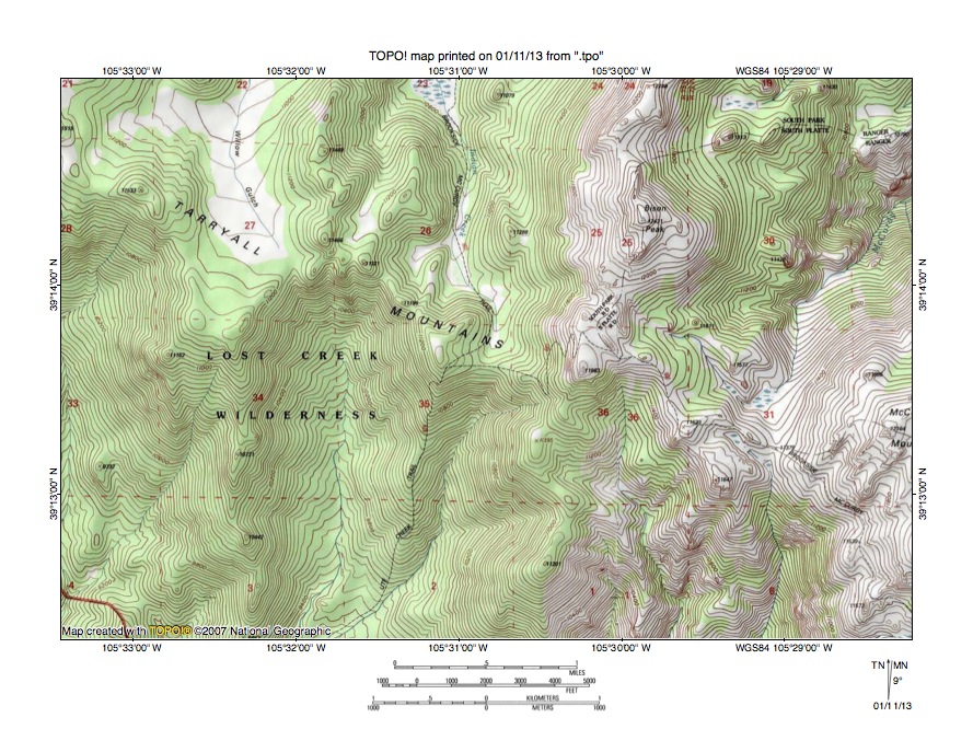
Figure 8: Detailed map of Indian Creek-Ute Creek drainage divide area. United States Geological Survey map digitally presented using National Geographic Society TOPO software.
Figure 8 provides a detailed map of the Indian Creek-Ute Creek drainage divide area seen in less detail in figure 7. The map contour interval for figure 8 is 40 feet. The Tarryall Mountains extend in a west-northwest to east-southeast direction along the crest of the southwest-facing escarpment, which is the northeast wall of the deep south-southeast oriented Tarryall Creek valley. Tarryall Creek is located south of figure 8 and flows in a southeast direction to join the north-northeast oriented South Platte River south and east of figure 8. Willow Gulch originates in section 27 (near the crest of the escarpment) and drains in a north-northwest and north direction to the north edge of figure 8 (west half). North of figure 8 Willow Gulch drains to southeast oriented South Fork Lost Creek, which then flows to southeast oriented Lost Creek, which is located in the same valley as south, southeast, north, and northeast oriented Goose Creek, which flows to the north-northeast oriented South Platte River. Indian Creek originates in section 26 (near the crest of the escarpment) and flows in a north direction to the north center edge of figure 8. North of figure 8 Indian Creek flows to Willow Gulch. The south and south-southwest oriented streams originating south of the Willow Gulch and Indian Creek headwaters in sections 34 and 35 and draining to the south edge of figure 8 (west of center) are headwaters of south-southwest oriented Ute Creek, which south of figure 8 flows to southeast oriented Tarryall Creek. The Willow Gulch-Ute Creek drainage divide low point in section 27 has an elevation of between 11,120 and 11,160 feet and the Indian Creek-Ute Creek drainage divide low point in section 35 has an elevation of between 11,160 and 11,200 feet. Bison Peak in section 25 rises to 12,431 feet. Elevations along the drainage divide west of Willow Gulch rise to 11,533 feet and North Tarryall Mountain (north and west of figure 8) rises to 11,902 feet. Depending on which elevations are used the Willow Gulch-Ute Creek through valley is at least 370 feet deep and it could be as much as 740 feet deep. In either case the through valleys are today hanging valleys, which were eroded by diverging and converging south oriented flood flow channels flowing to the deep Tarryall Creek valley prior to headward erosion of the southeast oriented Lost Creek valley. Floodwaters flowed across the escarpment face and eroded headcuts (or valleys) into the escarpment face.
Wigwam Creek-Goose Creek drainage divide area
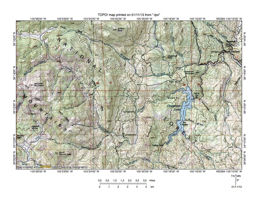
Figure 9: Wigwam Creek-Goose Creek drainage divide area. United States Geological Survey map digitally presented using National Geographic Society TOPO software.
Figure 9 provides a topographic map of the Wigwam Creek-Goose Creek drainage divide area east and slightly south of figure 7 and includes overlap areas with figure 7. The map contour interval for figure 9 is 50 meters. Cheeseman Lake in the east half of figure 9 is a large reservoir flooding the South Platte River valley. The South Platte River flows in a north-northeast direction from the south edge of figure 9 (east half) to near the northeast corner of figure 9. Tarryall Creek flows in a southeast direction across the southwest corner of figure 9 and south of figure 9 joins the South Platte River. Lost Creek flows in an east, south, and southeast direction from the west edge of figure 9 (near northwest corner) and ends as a surface stream. However, the southeast oriented Lost Creek valley (which is approximately 1000 meters deep) continues and becomes the south-southeast headwaters valley of Goose Creek, which then flows in a southeast, north, and northeast direction to join the South Platte River near the north end of Cheeseman Lake. Note how Goose Creek turns in a south direction to join the north oriented South Platte River at Cheeseman Lake. Wigwam Creek originates near the north edge of figure 9 just east of the east oriented Lost Creek segment near the northwest corner of figure 9 and then flows in a southeast, east, and east-northeast direction to join the South Platte River north of Cheeseman Lake. Several significant through valleys can be seen crossing major drainage divides in figure 9. Perhaps the simplest through valley is the Lost Creek-Goose Creek through valley, which is a continuous valley. The Lost Creek-Wigwam Creek through valley near the northwest corner of figure 9 is approximately 250 meters deep and was eroded by east oriented flood flow moving from the southeast and east oriented Lost Creek valley (west of figure 9) to the southeast oriented Wigwam Creek valley and probably diverged from a south and southeast oriented flood flow channel on the Lost Creek alignment. Headward erosion of a deeper valley on the Lost Creek alignment beheaded the east oriented flood flow channel leading to the Wigwam Creek valley. Floodwaters on the west end of the beheaded flood flow channel reversed flow direction to create a west oriented Lost Creek tributary drainage route. Another deep through valley in the southwest quadrant of figure 9 links the east and northeast oriented Hankins Gulch valley (which drains to Goose Creek) with the southwest oriented Hay Creek valley (which drains to the southeast oriented Tarryall Creek valley). This 300-meter deep through valley was probably eroded by east oriented flood flow prior to headward erosion of the much deeper southeast oriented Tarryall Creek valley and its southwest oriented Hay Creek tributary valley. A north-to-south oriented through valley west of Cheeseman Mountain links the east-northeast oriented Wigwam Creek and south oriented Pine Creek valleys with the north end of Cheeseman Reservoir and the north oriented South Platte River valley. Southeast oriented South Platte River tributaries in the northeast corner region of figure 9 are barbed tributaries and provide evidence of south oriented flood flow channels captured by reversed flood flow on the present day north oriented South Platte River alignment. South oriented Wigwam Creek tributaries in the northeast quadrant of figure 9 originated as south oriented flood flow channels captured by headward erosion of the east and east-northeast oriented Wigwam Creek valley. Prior to headward erosion of the east and east-northeast oriented Wigwam Creek valley the south oriented flood flow channels continued in south directions to the present day north oriented Goose Creek and South Platte River valleys seen in the southeast quadrant of figure 9.
Detailed map of Wigwam Creek-South Platte River drainage divide area
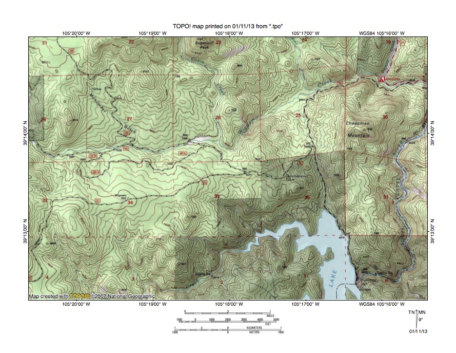
Figure 10: Detailed map of Wigwam Creek-South Platte River drainage divide area. United States Geological Survey map digitally presented using National Geographic Society TOPO software.
Figure 10 provides a detailed topographic map of the Wigwam Creek-South Platte River drainage divide area seen in less detail in figure 9. The map contour interval for figure 10 is 40 feet. The north end of Cheeseman Lake can be seen in southeast quadrant of figure 10. The South Platte River flows in an east direction from Cheeseman Lake (in section 6 near southeast corner of figure 10) and then turns to flow in a north and north-northeast direction to the east edge of figure 10 (north of center). Wigwam Creek flows in a southeast, east, east-northeast, and east direction from the west edge of figure 10 (north of center) to the east edge of figure 10 (near northeast corner) and east of figure 10 joins the north-northeast oriented South Platte River. The south oriented stream joining Wigwam Creek in section 25 is Pine Creek and the south-southeast oriented stream joining Wigwam Creek in section 26 is Cabin Creek. Cheeseman Mountain is located in section 30 and a road west of Cheeseman Mountain travels from the Wigwam Creek valley to the Cheeseman Lake eastern shoreline. The road is located in a north-to-south oriented through valley linking the south oriented Pine Creek valley with the north oriented South Platte River valley at Cheeseman Lake. The through valley floor elevation at the drainage divide is 7208 feet. A somewhat shallower through valley in the northeast corner of section 35 links the south-southeast oriented Cabin Creek valley with the north oriented South Platte River valley at Cheeseman Lake and has a floor elevation of 7471 feet. Cheesman Mountain reaches an elevation of 7923 feet. Elevations near the west edge of figure 10 exceed 8000 feet and rise considerably further to the west. These elevations suggest the Pine Creek-South Platte River through valley is approximately 700 feet deep and the Cabin Creek-South Platte River through valley is almost 500 feet deep. These north-to-south oriented through valleys were eroded by south oriented flood flow channels converging with a south oriented flood flow channel on the present day north oriented South Platte River alignment. South oriented flood flow on the South Platte River alignment probably flowed to what at that time was the newly eroded southeast oriented Arkansas River valley. Headward erosion of a deep southeast and northeast oriented South Platte River valley into northeast Colorado from western Nebraska beheaded south oriented flood flow channels on the South Platte River alignment. Floodwaters on north ends of the beheaded flood flow channels reversed flow direction to flow to the newly eroded and deeper southeast and northeast oriented South Platte River valley. The flood flow reversal was probably greatly aided by ice sheet related crustal warping that was raising Colorado and mountain masses within this essay’s study region as floodwaters flowed across the region.
Additional information and sources of maps studied
This essay has provided only a sample of the detailed topographic map evidence supporting the flood erosion interpretation. Many additional illustrations could be provided. Readers are encouraged to look at mosaics of detailed topographic maps to see the abundance of available data. Maps used in this study were created and published by the United States Geologic Survey and can be obtained directly from the United States Geological Survey and/or from dealers offering United States Geological Survey maps. Hard copy maps can also be observed at United States Geological Survey map depositories, which are located throughout the United States and elsewhere. Illustrations used here were created using National Geographic Society TOPO software and digital map data. TOPO software and map data can be obtained from the National Geographic Society and/or dealers offering National Geographic Society digital map data.

Leave a comment