
Abstract:
This essay uses topographic map evidence to interpret landform origins in the Bear Creek-North Fork South Platte River drainage divide area in the Colorado Front Range. Bear Creek is an east-northeast, southeast, northeast, and east oriented stream originating near Mount Evans and flowing to Colorado Piedmont to join the north-northeast oriented South Platte River. The North Fork South Platte River is located south of Bear Creek and originates near the east-west continental divide before flowing in a southeast direction (with some northeast jogs) to join the north oriented South Platte River as a barbed tributary. North Fork South Platte River tributaries from the north are oriented in southeast directions and are linked by through valleys (or passes) with north and northeast oriented Bear Creek tributary valleys. Multiple north-to-south oriented through valleys (or passes) cross the Bear Creek-North Fork South Platte River drainage divide. The through valleys (or passes) were eroded by diverging and converging south oriented flood flow channels at a time when the Colorado Front Range was just beginning to emerge. Floodwaters were derived from the western margin of a thick North American ice sheet and flowed from western Canada to and across Colorado as the Front Range emerged. The Front Range emerged as floodwaters flowed across it, as ice sheet related crustal warping raised Colorado and the Front Range mountain mass, and as deep valleys eroded headward into Colorado from both the east and the west. The North Fork South Platte River valley eroded headward from south oriented flood flow channels on the present day north oriented South Platte River alignment to capture south oriented flood flow in the emerging mountain mass and southeast oriented tributary valleys eroded headward from the newly eroded North Fork South Platte River valley to better capture the south oriented flood flow. Headward erosion of the Bear Creek valley and its northeast oriented tributary valleys then beheaded south oriented flood flow channels to the newly eroded North Fork South Platte River tributary valleys. Floodwaters on north ends of the beheaded flood flow channels reversed flow direction to flow to the deeper beheading valley and to create north and northwest oriented tributary drainage routes. Headward erosion of what is today the southeast and northeast oriented South Platte River valley (downstream from Greeley) at some point in this history beheaded and reversed south oriented flood flow channels on the Colorado Piedmont to create north oriented South Platte River tributary drainage routes and the north oriented South Platte River drainage route. The north oriented South Platte River drainage route captured flood flow from the southeast and east oriented valleys, which had eroded headward into the emerging Front Range. The flood flow captures and reversals were greatly aided by ice sheet related crustal warping that was raising Colorado and Colorado mountain ranges.
Preface
The following interpretation of detailed topographic map evidence is one of a series of essays describing similar evidence for all major drainage divides contained within the Missouri River drainage basin and for all major drainage divides with adjacent drainage basins. The research project is interpreting evidence in the context of a previously unexplored deep glacial erosion paradigm, which is fundamentally different from most commonly accepted North American glacial history interpretations. Project essays are listed on the sidebar category list under their appropriate Missouri River tributary drainage basin, Missouri River segment drainage basin (by state), and/or state in which the Missouri River drainage basin is located.
Introduction
The purpose of this essay is to use topographic map interpretation methods to explore the Bear Creek-North Fork South Platte River drainage divide area landform origins in the Colorado Front Range. Map interpretation methods can be used to unravel many geomorphic events leading up to formation of present-day drainage routes and development of other landform features. While each detailed topographic map feature provides detailed evidence to be explained, the solution must be consistent with explanations for adjacent area map evidence as well as solutions to big picture map evidence puzzles. I invite readers to improve upon my solutions and/or to propose alternate solutions that better explain evidence and are also consistent with adjacent map area and big-picture evidence. Readers may do so either by making comments here or by writing and publishing their own essays and then by leaving a link to those essays in a comment here.
This essay is also exploring a new geomorphology paradigm in which erosional landforms are interpreted as evidence left by immense glacial melt water floods. Implied in that interpretation is the immense floods were derived from a thick North American ice sheet that created a deep “hole” in the North American continent and also melted fast. The previously unexplored paradigm being tested in this and other Missouri River drainage basin landform origins research project essays is a thick North American ice sheet, comparable in thickness to the Antarctic ice sheet, occupied the North American region usually recognized to have been glaciated, and through its weight and erosive actions created a deep North American “hole”. The southwestern rim of that deep “hole” is today preserved in the high Rocky Mountains. The ice sheet through its weight and deep erosion (and perhaps deposition along major south-oriented melt water flow routes) caused significant crustal warping and tectonic change, through its action of melting fast produced immense floods that flowed across the continent, and through its action of melting fast systematically opened up space in the ice sheet created “hole” so headward erosion of newly developed north-oriented drainage systems captured immense south-oriented melt water floods and diverted immense melt water floods north into space the ice sheet had once occupied.
If this previously unexplored paradigm is correct the geographic region explored by this essay should contain evidence of immense floods that were captured by headward erosion of new valley systems so as to cause the floods to flow in a different direction. Ability of this previously unexplored paradigm to explain Bear Creek-North Fork South Platte River drainage divide area landform evidence in the Colorado Front Range will be regarded as evidence supporting the “thick ice sheet that melted fast” paradigm.
Bear Creek-North Fork South Platte River drainage divide area location map
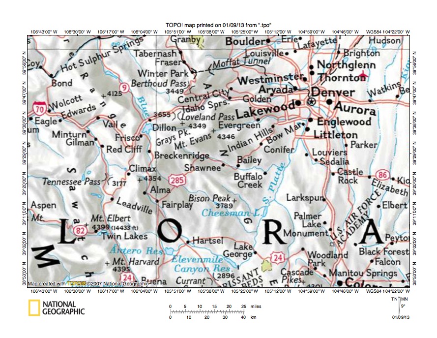
Figure 1: Bear Creek-North Fork South Platte River drainage divide area location map (select and click on maps to enlarge). National Geographic Society map digitally presented using National Geographic Society TOPO software.
Figure 1 provides a location map for the Bear Creek-North Fork South Platte River drainage divide area in the Colorado Front Range and illustrates a region in central Colorado. Denver is located in the northeast quadrant of figure 1 and the Colorado Front Range is west of Denver. The South Platte River flows in a southeast direction to Elevenmile Reservoir (near south center edge of figure 1) and then turns to flow in a north-northeast direction to Denver and the north edge of figure 1 (east half). North of figure 1 (near Greeley) the South Platte River turns to flow in a southeast and then northeast direction to join the Nebraska Platte River in western Nebraska. The North Fork South Platte River is an unlabeled South Platte River tributary near the center of figure 1 and flows through or near the towns of Shawnee, Bailey, and Buffalo Creek. Bear Creek is the unlabeled South Platte River tributary north of the North Fork South Platte River and originates near Mount Evans before flowing through or near the town of Evergreen and then flowing to join the South Platte River near Englewood. The unlabeled east oriented South Platte River tributary north of Bear Creek and flowing through or near the towns of Idaho Springs and Golden is Clear Creek. West of the Clear Creek and Bear Creek headwaters is the north and north-northwest oriented Blue River, which flows to the southwest, northwest, and southwest oriented Colorado River (unlabeled in figure 1), which flows across the northwest corner of figure 1. The north oriented Blue River headwaters are located almost directly north of the southeast oriented South Platte River headwaters. West of the Blue River the Eagle River (not labeled in figure 1) originates near Tennessee Pass and flows in a north, northwest and west direction to join the Colorado River west of figure 1. The Arkansas River originates south of the Eagle River headwaters at Tennessee Pass and flows in a south-southeast direction to the south edge of figure 1 (west half). The Bear Creek-North Fork South Platte River drainage divide area investigated in this essay is located south of Bear Creek and north of the North Fork South Platte River and extends west to the Clear Creek-North Fork South Platte River drainage divide area west of Mount Evans.
Colorado drainage routes developed during immense melt water floods at a time when Colorado mountain ranges were just beginning to emerge. Floodwaters from the western margin of a thick North American ice sheet flowed from western Canada across Montana and Wyoming and then across Colorado. Colorado mountain ranges emerged as floodwaters flowed across them, as ice sheet related crustal warping raised mountain masses and the entire state of Colorado, and as deep valleys eroded headward into the region from both the east and the west to capture the massive south oriented flood flow. Initially floodwaters flowed in south directions, although flood flow directions changed as crustal warping raised the region and mountain masses and also as headward erosion of deep valleys captured the south oriented flood flow. The north-northeast oriented South Platte River drainage route and routes of north oriented South Platte River tributaries seen near the east edge of figure 1 originated as south oriented flood flow channels probably flowing to what at that time was the newly eroded southeast oriented Arkansas River valley (located south of the east half of figure 1). The southeast oriented South Platte River headwaters and tributaries seen in figure 1 are flowing in valleys that eroded headward along and across the south and southeast oriented flood flow in emerging mountain regions west of south oriented flood flow channels on the present day north oriented South Platte River alignment. Headward erosion of the deep southwest oriented Colorado River valley beheaded flood flow channels west of the present day continental divide. Floodwaters on north ends of the beheaded flood flow channels reversed flow direction to flow to the much deeper Colorado River valley and to create north, northwest, and west oriented Colorado River tributary drainage routes (e.g. Blue River and Eagle River). At about the same time headward erosion of the deep southeast and northeast oriented South Platte River valley (not seen in figure 1) from western Nebraska beheaded flood flow channels on the Colorado Piedmont (east of the emerging Colorado Front Range). Floodwaters on north ends of the beheaded flood flow channels reversed flow direction to flow to the deeper southeast and northeast oriented South Platte River valley and to create north oriented South Platte River tributary drainage routes and the north-northeast oriented South Platte River drainage route. The north-northeast oriented South Platte River drainage route captured drainage from the southeast and east oriented valleys, which had eroded headward into the emerging mountains west of the newly reversed South Platte River drainage route.
Detailed location map for Bear Creek-North Fork South Platte River drainage divide area

Figure 2: Detailed location map of Bear Creek-North Fork South Platte River drainage divide area. United States Geological Survey map digitally presented using National Geographic Society TOPO software.
Figure 2 provides a detailed location map for the Bear Creek-North Fork South Platte River drainage divide area in the Colorado Front Range. Green colored areas are National Forest lands, which in Colorado are usually found in mountain regions. The Denver metropolitan area is located in the northeast corner of figure 2. The South Platte River (not labeled in figure 2) flows in a north-northeast direction from the south edge of figure 2 (east half) to the northeast corner of figure 2. Near the south edge of figure 2 the South Platte River is flowing in South Platte Canyon (labeled “Canyon” in figure 2). The North Fork South Platte River originates near Whale Peak (near west edge of figure 2-south of center) and flows in a southeast and east direction to Grant. From Grant the North Fork South Platte River flows in a southeast direction to Estabrook and then in a northeast and east direction to Buffalo Creek before turning a northeast and then southeast direction to join the South Platte River near the town of South Platte. Geneva Creek is a southeast oriented tributary joining the North Fork South Platte River near Grant. Further east Deer Creek, Elk Creek, and Kennedy Gulch are southeast oriented tributaries flowing to the North Fork South Platte River. Mount Evans is located north of the Deer Creek headwaters. Bear Creek originates near Mount Evans and flows in an east-northeast and east direction near or through the towns of Brookvale, Evergreen, and Idledale before joining the South Platte River. Most Bear Creek tributaries from the south are not significant enough to be shown in figure 2, although an unlabeled stream (Turkey Creek) joins Bear Creek east of Morrison. North Turkey Creek flows in a north and east direction from near Aspen Park to join east and north oriented South Turkey Creek (which originates near Aspen Park) to form north and northeast oriented Turkey Creek. Loveland Pass is located near the west edge of figure 2 (north half). Clear Creek originates on the north side of Loveland Pass and flows in an east, north, and east direction through Georgetown to Idaho Springs and the flows in an east direction to Golden before continuing in an east-northeast direction to join the South Platte River near the northeast corner of figure 2. The north oriented tributary originating near Mount Wilcox and joining Clear Creek at Georgetown is South Clear Creek. Before leaving figure 2 note the large number of southeast oriented streams in the south half of figure 2, many of which flow to the North Fork South Platte River. These southeast oriented streams are relics from the time when south oriented floodwaters in the emerging mountain mass was being captured by the headward erosion of southeast oriented valleys from a south oriented flood flow channel on the present day north oriented South Platte River alignment.
Bear Creek-Deer Creek drainage divide area
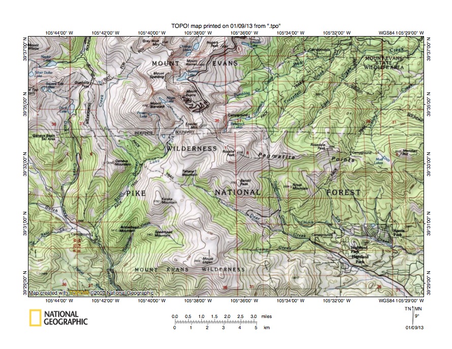
Figure 3: Bear Creek-Deer Creek drainage divide area. United States Geological Survey map digitally presented using National Geographic Society TOPO software.
Figure 3 provides a topographic map of Bear Creek-Deer Creek drainage divide area. The map contour interval for figure 3 is 50 meters. Geneva Creek flows in a south-southeast direction from the west center edge of figure 3 to the south edge of figure 3 (west half). South of figure 3 Geneva Creek flows to the southeast oriented North Fork South Platte River, which eventually reaches the north-northeast oriented South Platte River. Guanella Pass is located in the northwest corner region of figure 3. The north oriented stream on the north side of Guanella Pass is South Clear Creek, which flows to north and east oriented Clear Creek, which joins the South Platte River near Denver. Two south oriented streams flow from Guannella Pass to Geneva Creek. The western stream is south oriented Duck Creek and the eastern stream is south-southwest, south, southeast, and south-southwest oriented Scott Gomer Creek. A Pack Trail follows the Scott Gomer Creek valley in a south and southeast direction from Guanella Pass and then continues in a southeast direction to the southeast oriented Deer Creek valley, which drains to near the southeast corner of figure 3. South and east of figure 3 Deer Creek flows to the North Fork South Platte River. Mount Evans is located east of Guanella Pass and Bear Creek originates on the east side of Mount Evans and flows in an east-northeast direction to near the northeast corner of figure 3. North and east of figure 3 Bear Creek flows to the South Platte River (south of Denver). Guanella Pass is a deep north-to-south oriented through valley linking the north oriented South Clear Creek valley with the two south oriented Geneva Creek tributary valleys. The Guanella Pass floor elevation is between 3450 and 3500 meters. Mount Bierstadt to the east rises to 4282 meters and Square Top Mountain to west (just west of figure 3) rises to more than 4160 meters suggesting Guanella Pass could be as much 660 meters deep. Guanella Pass was eroded by south oriented flood flow moving to what at that time was the newly eroded south-southeast oriented Geneva Creek valley, which had eroded headward from the newly eroded southeast oriented North Fork South Platte River valley. Prior to headward erosion of the deep south-southwest oriented Scott Gomer Creek valley at least some of the south oriented flood flow had moved in a southeast direction between Kataka Mountain and Tahana Mountain to the southeast oriented Deer Creek valley, which had eroded headward from the newly eroded North Fork South Platte River valley. The pass between Kataka and Tahana Mountains has a floor elevation of between 3550 and 3600 meters. Kataka Mountain rises to 3792 meters suggesting the pass is 200 meters deep or deeper. Like Guanella Pass the pass is a water-eroded valley, which was eroded by a southeast oriented flood flow channel, which was subsequently beheaded by headward erosion of the deeper south-southwest oriented Scott Gomer Creek valley.
Detailed map of Scott Gomer Creek-Deer Creek drainage divide area
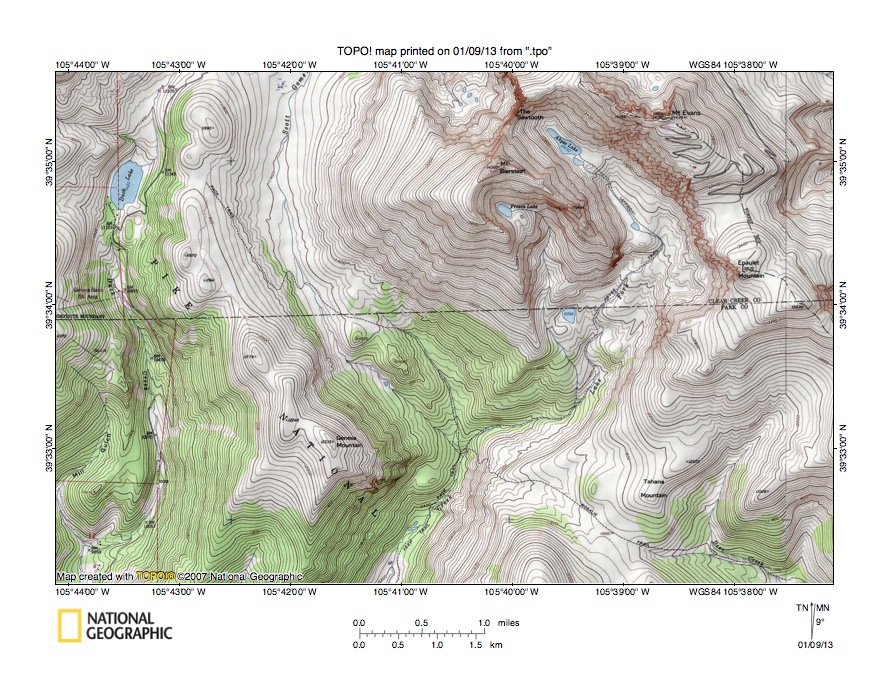
Figure 4: Detailed map of Scott Gomer Creek-Deer Creek drainage divide area. United States Geological Survey map digitally presented using National Geographic Society TOPO software.
Figure 4 provides a detailed topographic map of the Scott Gomer Creek-Deer Creek drainage divide area seen in less detail in figure 5. The map contour interval for figure 4 is 40 feet. Figure 4 needs to be viewed in conjunction with figure 3 so the big picture can be seen. Duck Lake is located near the northwest corner of figure 4 and Duck Creek flows in a south direction from Duck Lake to near the southwest corner of figure 4. Scott Gomer Creek flows in a south, south-southeast, and south-southwest direction from the north edge (west half) to the south edge of figure 4 (west half). Guanella Pass is located north of the ridge between Duck Creek and Scott Gomer Creek (and north of figure 4) and is a deep north-to-south oriented through valley linking the south oriented Duck Creek and south, south-southeast, and south-southwest oriented Scott Gomer Creek valleys with the north oriented South Clear Creek valley. South of figure 4 Duck Creek and Scott Gomer Creek flow to south-southeast oriented Geneva Creek, which then flows to the southeast oriented North Fork South Platte River. Deer Creek is the southeast oriented stream originating near the southeast corner of figure 4 and then flowing to the southeast corner of figure 4. South and east of figure 4 Deer Creek flows in a southeast direction to join the North Fork South Platte River. The Rosalie Trail crosses the drainage divide between the Scott Gomer Creek valley and the Deer Creek valley using a pass between Kataka Mountain (south of figure 4) and Tahana Mountain. The pass floor elevation is shown as being 11,660 feet. Kataka Mountain to the south rises to 12,441 feet and the mountain to the north rises much higher suggesting the pass is at least 780 feet deep. The pass was eroded by a southeast oriented flood flow channel with water moving from the present day north oriented South Clear Creek alignment to the southeast oriented Deer Creek valley, which was eroding headward from what at that time was the newly eroded North Fork South Platte River valley. A south-southwest oriented flood flow channel on the present day south-southwest oriented Scott Gomer Creek alignment probably diverged from that southeast oriented flood flow channel, although the diverging flood flow channel floor was at that time comparable in elevation to the elevation of the southeast oriented flood flow channel. Headward erosion of the southeast North Fork South Platte River valley and its south-southeast oriented Geneva Creek valley enabled a much deeper valley head to erode headward along the south-southwest oriented Scott Gomer Creek alignment. The deeper valley captured the south and southeast oriented flood flow channel and beheaded the southeast oriented flood flow route to the Deer Creek valley. Today the Rosalie Trail climbs almost 1000 feet from the Scott Creek valley to reach the pass between Kataka Mountain and Tahana Mountain, which suggests floodwaters lowered the floor of the Scott Gomer Creek valley by approximately 1000 feet since the time floodwaters flowed to the southeast oriented Deer Creek valley.
Deer Creek-North Fork South Platte River drainage divide area
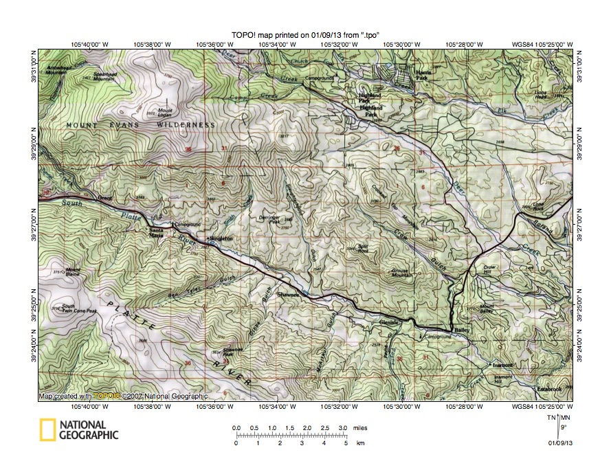
Figure 5: Deer Creek-North Fork South Platte River drainage divide area. United States Geological Survey map digitally presented using National Geographic Society TOPO software.
Figure 5 illustrates the Deer Creek-North Fork South Platte River drainage divide area south and east of figure 3 and there is an overlap area with figure 3. The map contour interval for figure 5 is 50 meters. The North Fork South Platte River flows in an east and southeast direction from the west edge of figure 5 (north of center) to Estabrook near the southeast corner of figure 5. At Estabrook the North Fork South Platte River turns to flow in a northeast, east, northeast, and southeast direction to join the north-northeast oriented South Platte River. Geneva Creek flows in a south-southeast direction from the west edge of figure 5 (north half) to join the North Fork South Platte River near Grant (near west edge of figure 5). Mount Logan is located in the northwest quadrant of figure 5. The North Fork South Platte River valley south of Mount Logan is approximately 1000 meters deep. Deer Creek flows in a southeast direction from the north edge of figure 5 (west of center) to the east edge of figure 5 (south of center). East of figure 5 Deer Creek joins the North Fork South Platte River. Crow Gulch drains in a southeast and south direction to join the North Fork South Platte River near Bailey (in southeast quadrant of figure 5). North-to south oriented through valleys can be seen crossing the Deer Creek-North Fork South Platte River drainage divide east of Mount Logan. South of Highland Park through valleys (or passes) link an east-northeast oriented Deer Creek tributary valley with the southeast and south oriented Crow Gulch valley and with the south-southeast and south oriented Slaughterhouse Gulch valley. The through valleys west of Crooked Top Mountain have floor elevations of between 2900 and 2950 meters. Crooked Top Mountain rises to 3150 meters suggesting the through valleys are at least 200 meters deep. The through valley floors are at least 200 meters higher than the floor of the Deer Creek valley to the north, yet the through valleys are water-eroded features. Diverging and converging south oriented flood flow channels eroded the through valleys or passes at a time when the deep Deer Creek valley to the north did not exist. Headward erosion of the deep southeast oriented Deer Creek valley and its east oriented tributary valley from what at that time was the newly eroded North Fork South Platte River valley captured the south oriented flood flow channels and ended south oriented flood flow to the Crow Gulch and Slaughterhouse Gulch valleys. Other somewhat shallower north-to-south oriented through valleys can be seen in figure 5 crossing the various drainage divides
Detailed map of Deer Creek-North Fork South Platte River drainage divide area

Figure 6: Detailed map of Deer Creek-North Fork South Platte River drainage divide area. United States Geological Survey map digitally presented using National Geographic Society TOPO software.
Figure 6 provides a detailed topographic map of the Deer Creek-North Fork South Platte River drainage divide area seen in less detail in figure 5. The map contour interval for figure 6 is 40 feet. The North Fork South Platte River flows in an east-southeast direction from the west edge of figure 6 (south half) to Bailey and then to the south edge of figure 6 (west of center). South and east of figure 6 the North Fork South Platte River flows in a southeast, northeast, east, northeast and southeast direction to join the north-northeast oriented South Platte River. Crow Gulch drains in a southeast and south direction from near the northwest corner of figure 6 to join the North Fork South Platte River at Bailey. Deer Creek flows in a southeast direction from the north edge of figure 6 (east of center) to the east center edge of figure 6. East of figure 6 Deer Creek joins the North Fork South Platte River. The south oriented Crow Gulch valley segment north of Bailey is located between Mount Bailey (on the east) and Grouse Mountain (just west of figure 6) and crosses the 8000-foot contour line near the south margin of section 20. Mount Bailey reaches an elevation of 9095 feet and Grouse Mountain is much higher suggesting the Crow Gulch valley is at least 1000 feet deep. The highway going north from Bailey follows the south oriented Crow Gulch valley and then turns in a northeast direction and crosses southeast oriented Deer Creek near the north edge of figure 6. The highway is located in a through valley linking the Deer Creek valley with the Crow Gulch valley. The highway crosses the drainage divide west of Crow Hill near the corner of sections 16, 17, 20, and 21 at an elevation of approximately 8560 feet. In the north half of section 22 to the east is an unnamed hill with an observatory, which reaches an elevation of 8769 feet. Depending on which elevations are used the through valley in which the highway is located is anywhere from 200 to 500 feet deep. Study of figure 6 reveals a complex of through valleys surrounding the hills and/or mountains. Most of these through valleys are only a few hundred feet deep, but the through valleys are all water-eroded features. The through valleys were eroded by diverging and converging south oriented flood flow channels prior to headward erosion of the southeast oriented Deer Creek valley. The south oriented flood flow channels were flowing to what at that time was the newly eroded North Fork South Platte River valley.
Yankee Creek-Elk Creek drainage divide area

Figure 7: Yankee Creek-Elk Creek drainage divide area. United States Geological Survey map digitally presented using National Geographic Society TOPO software.
Figure 7 provides a topographic map of the Yankee Creek-Elk Creek drainage divide area east of figure 3 and is located north and east of figure 5 and includes overlap areas with figures 3 and 5. The map contour interval for figure 7 is 50 meters. Deer Creek (not labeled in figure 7) can be seen flowing in a southeast direction through Highland Park in the southwest corner of figure 7. South of figure 7 Deer Creek flows in a southeast direction to join the North Fork South Platte River. Elk Creek flows in an east-southeast, east-northeast, and southeast direction from the west edge of figure 7 (south half) to the south center edge of figure 7. South of figure 7 Elk Creek flows in a south-southeast and south direction to join the North Fork South Platte River. Meridian Hill is a labeled high point in the west center area of figure 7 and North Elk Creek originates south of Meridian Hill before flowing in a southeast direction to join Elk Creek. The North Fork North Elk Creek originates east of Meridian Hill and flows in a south-southeast direction to join North Elk Creek, which then joins Elk Creek. North of the North Fork North Elk Creek headwaters are headwaters of north oriented Yankee Creek, which flows to the north edge of figure 7 (west of center). North of figure 7 Yankee Creek flows to east-northeast oriented Bear Creek. A north-to-south oriented through valley links the north oriented Yankee Creek valley with the south-southeast oriented North Fork North Elk Creek valley. The through valley floor elevation at the drainage is between 3050 and 3100 meters. Black Mountain to the southeast rises to more than 3250 meters and Meridian Hill to the west rises to 3502 meters suggesting the through valley is at least 150 meters deep. More through valleys are located west of Meridian Hill and link the north and northeast oriented Indian Creek valley (which north of figure 7 drains to Bear Creek) with south-southeast oriented Elk Creek tributary valleys and with the North Elk Creek valley. These through valleys have floor elevations of between 3500 and 3550 meters. Rosedale Peak to the west rises to 3664 meters suggesting these through valleys are also at least 150 meters deep. Additional through valleys cross the Bear Creek-Elk Creek drainage divide in figure 7. The through valleys were eroded by diverging and converging south oriented flood flow channels prior to headward erosion of the deep Bear Creek valley (north of figure 7). Floodwaters deeply eroded the region until headward erosion of the east-northeast oriented Bear Creek valley (north of figure 7) and northeast oriented tributary valleys beheaded the south oriented flood flow channels. Floodwaters on north ends of the beheaded flood flow channels reversed flow direction to create north oriented Bear Creek tributary drainage routes.
Detailed map of Yankee Creek-North Fork North Elk Creek drainage divide area

Figure 8: Detailed map of Yankee Creek-North Fork North Elk Creek drainage divide area. United States Geological Survey map digitally presented using National Geographic Society TOPO software.
Figure 8 provides a detailed map of the Yankee Creek-North Fork North Elk Creek drainage divide area seen in less detail in figure 7. The map contour interval for figure 8 is 40 feet. North Elk Creek flows in a southeast direction across the southwest corner of figure 8 and south of figure 8 flows in a southeast and south-southeast direction to join south-southeast and south oriented Elk Creek, which flows to north Fork South Platte River. North Fork North Elk Creek originates near the west center edge of section 3 (in center of figure 8) and flows in a south-southeast direction to the south center edge of figure 8. South of figure 8 North Fork North Elk Creek joins North Elk Creek. The north oriented stream originating in the northeast quadrant of section 3 is Yankee Creek, which flows to the north edge of figure 8 (slightly east of center). North of figure 8 Yankee Creek flows to east-northeast oriented Bear Creek. A north-to-south oriented through valley or pass links the north oriented Yankee Creek valley with the south-southeast oriented North Fork North Elk Creek valley. The through valley elevation at its lowest point is between 10,000 and 10,040 feet. Elevations on Black Mountain near the southeast corner of figure 8 rise to 10,756 feet and elevations near the west center edge of figure 8 rise to 11,460 feet suggesting the through valley is more than 700 feet deep. The deep through valley in section 3 is just one of several through valleys crossing the Bear Creek-Elk Creek drainage divide seen in figure 8. Floors of other through valleys are somewhat higher, but as a group the through valleys are located between high points at Black Mountain and Meridian Hill (just west of the west center edge of figure 8). As a group these through valleys define a much broader north-to-south through valley which was eroded across the present day Bear Creek-Elk Creek drainage divide. This broader through valley is a water-eroded valley and was eroded by south oriented flood flow prior to headward erosion of the deeper east-northeast oriented Bear Creek valley (north of figure 8). The individual through valleys were eroded by diverging and converging flood flow channels on the floor of the broader through valley. Headward erosion of the deep east-northeast oriented Bear Creek valley (north of figure 8) and its northeast oriented tributary valleys beheaded and reversed the south oriented flood flow channels to create north oriented Bear Creek tributary drainage routes.
Bear Creek-Turkey Creek drainage divide area

Figure 9: Bear Creek-Turkey Creek drainage divide area. United States Geological Survey map digitally presented using National Geographic Society TOPO software.
Figure 9 provides a topographic map of the Bear Creek-Turkey Creek drainage divide area north and east of figure 7 and includes overlap areas with figure 7. The map contour interval for figure 9 is 50 meters. Hogback ridges along the Colorado Front Range eastern flank can be seen in the northeast corner of figure 9. Bear Creek flows in an east-northeast and southeast direction from the west edge of figure 9 (north of center) to Evergreen Lake (in north center area of figure 9). Bear Creek then flows in a northeast and east-southeast direction from Evergreen Lake to the east edge of figure 9 (near northeast corner). East of figure 9 Bear Creek joins the north-northeast oriented South Platte River. Aspen Park is a town located near the south center edge of figure 9. South Turkey Creek originates on the east side of Aspen Park and flows in an east, northeast, and north direction to join North Turkey Creek and to form north and east-northeast oriented Turkey Creek, which flows to the east edge of figure 9 (north half). East of figure 9 Turkey Creek joins Bear Creek, which then flows to the South Platte River. Black Mountain is located near the south edge of the southwest quadrant of figure 9. North Turkey Creek originates east of Black Mountain and flows in an east-southeast and east-northeast direction almost to Aspen Park and then turns to flow in a north, east, and east-northeast direction to join South Turkey Creek and to form north and east-northeast oriented Turkey Creek. Cub Creek originates north of Black Mountain and flows in a north, northeast, and north-northeast direction to join Bear Creek at the east end of Evergreen Lake. Through valleys link the North and South Turkey Creek valleys in the Aspen Park area. Aspen Park is located in an east-northeast oriented through valley linking the South Turkey Creek headwaters valley with the east-northeast and north oriented North Turkey Creek valley. Elevations at Aspen Park are between 2450 and 2500 meters. Berrian Mountain to the north rises to more than 2750 meters, as does the mountain to the south suggesting the through valley is at least 250 meters deep. South of the north oriented North Turkey Creek valley, and south of figure 9, a north-to-south oriented through valley links the north oriented North Turkey Creek valley with the southeast and south oriented Kennedy Gulch valley, which drains to the final southeast oriented North Fork South Platte River segment (just before the North Fork joins the South Platte River as a barbed tributary). A 200-meter deep north-to-south oriented through is located between Berrian Mountain and Doublehead Mountain and links the east oriented North Turkey Creek valley with the east oriented South Turkey Creek valley. Study of figure 9 reveals numerous other through valleys linking various drainage routes. These through valley are all water-eroded landforms and were eroded by diverging and converging south oriented flood flow channels which crossed the emerging Colorado Front Range. Headward erosion of deep east and northeast oriented valleys captured the south oriented flood flow and floodwaters on north ends of beheaded flood flow routes reversed flow direction to flow to the deeper beheading valley. The north oriented North and South Turkey Creek segments were created by reversals of flood flow on beheaded south oriented flood flow channels.
Detailed map of Cub Creek-North Turkey Creek drainage divide area
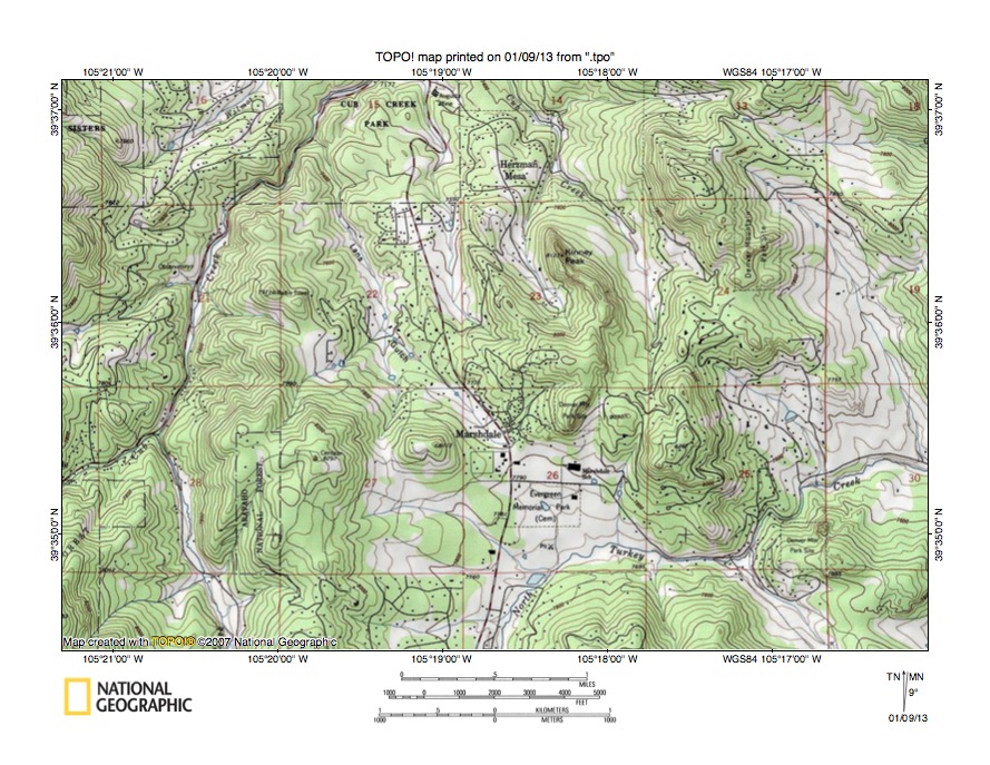
Figure 10: Detailed map of Cub Creek-North Turkey Creek drainage divide area. United States Geological Survey map digitally presented using National Geographic Society TOPO software.
Figure 10 provides a detailed topographic map of the Cub Creek-North Turkey Creek drainage divide area seen in less detail in figure 9. The map contour interval for figure 10 is 40 feet. Cub Creek flows in a northeast and north-northeast direction from the west edge of figure 10 (south half) to the north edge of figure 10 (west of center). North of figure 10 Cub Creek joins northeast and east oriented Bear Creek, which flows to the north oriented South Platte River. The north oriented Cub Creek tributary flowing from the south edge of figure 10 (west half) is Blue Creek. Lana Gulch originates at Marshdale and drains in a north-northwest direction to join Cub Creek in section 15. Little Cub Creek originates near the corner of sections 23, 24, 25, and 26 and flows in a north and northwest direction to the north center edge of figure 10 and joins Cub Creek north of figure 10 (just before Cub Creek joins Bear Creek). North Turkey Creek flows in a north, northeast, east, northeast, and east direction from the south center edge of figure 10 to the east edge of figure 10 (south half). East of figure 10 North Turkey Creek joins South Turkey Creek to form north and east-northeast oriented Turkey Creek, which then joins east oriented Bear Creek. Marshdale is located in a through valley linking the north-northwest oriented Lana Gulch valley with the north and east oriented North Turkey Creek valley. The through valley floor elevation is between 7800 and 7840 feet. Elevations on either side of the through valley exceed 8260 feet suggesting the through valley is at least 440 feet deep. A shallower north-to-south oriented through valley in the northeast quadrant of section 26 links the north and northwest oriented Little Cub Creek valley with the north and east oriented North Turkey Creek valley. Diverging and converging south oriented flood flow channels eroded these and other through valleys prior to headward erosion of the deep northeast and east oriented Bear Creek valley (north of figure 10). Floodwaters flowed in south directions on the present day north oriented Cub Creek, Lana Gulch, Little Cub Creek, and North Turkey Creek alignments to the southeast and south oriented Kennedy Gulch valley (south of figures 9 and 10), which then drained to south oriented flood flow channels on the present day north oriented South Platte River alignment. Headward erosion of the east-northeast oriented Turkey Creek valley (east of figure 10) beheaded and reversed flood flow channels east of figure 10, which enabled the east, northeast, and east oriented North Turkey Creek valley to then erode headward into the figure 10 area to capture the south oriented flood flow, with floodwaters on the north end of a beheaded flood flow route reversing flow direction to create the north oriented North Turkey Creek drainage route (south of figure 10). Headward erosion of the deep northeast and east oriented Bear Creek valley (north of figure 10) and its north-northeast oriented Cub Creek tributary valley next beheaded and reversed the south oriented flood flow channels to create the north oriented Little Cub Creek, Lana Gulch, and Cub Creek drainage routes.
Additional information and sources of maps studied
This essay has provided only a sample of the detailed topographic map evidence supporting the flood erosion interpretation. Many additional illustrations could be provided. Readers are encouraged to look at mosaics of detailed topographic maps to see the abundance of available data. Maps used in this study were created and published by the United States Geologic Survey and can be obtained directly from the United States Geological Survey and/or from dealers offering United States Geological Survey maps. Hard copy maps can also be observed at United States Geological Survey map depositories, which are located throughout the United States and elsewhere. Illustrations used here were created using National Geographic Society TOPO software and digital map data. TOPO software and map data can be obtained from the National Geographic Society and/or dealers offering National Geographic Society digital map data.

Leave a comment