
Abstract:
This essay uses topographic map evidence to interpret landform origins in the Middle Fork South Platte River-Arkansas River drainage divide area in Lake, Park, and Chaffee Counties, Colorado. The Middle Fork South Platte River originates on the south side of Hoosier Pass and flows in a south and south-southeast direction on the east side of the Mosquito Range to join the south-southeast, east, south, east, north and east oriented South Fork and to form the southeast and north-northeast oriented South Platte River, which then flows to the Platte, Missouri, and Mississippi Rivers A short distance to the west of Hoosier Pass the Arkansas River originates on the south side of Tennessee Pass and flows in a south and southeast direction on the west side of the Mosquito Range and eventually reaches the Mississippi River. North of Hoosier Pass are headwaters of the north and north-northwest oriented Blue River and north of Tennessee Pass are headwaters of the north, northwest, and west-northwest oriented Eagle River with the Blue and Eagle Rivers being tributaries to the southwest oriented Colorado River. Between Hoosier Pass and Tennessee Pass are additional passes linking the south oriented Arkansas River valley with north and northwest oriented Eagle and Blue River tributary valleys. Weston Pass at the south end of the Mosquito Range links headwaters of north-northwest, west, and southwest oriented Big Union Creek, which flows to the Arkansas River, with the south-southeast oriented South Fork South Platte River headwaters. High-level through valleys link north oriented South Fork South Platte River tributary valleys with the deep south-oriented Fourmile Creek valley, which parallels the deep Arkansas River valley before draining to the Arkansas River valley. These and other landforms as depicted on topographic maps are interpreted to have formed during immense melt water floods from the western margin of a thick North American ice sheet. Floodwaters flowed from western Canada to and across Colorado at a time when Colorado mountain ranges were just beginning to emerge. Colorado mountain ranges emerged as floodwaters flowed across them, as ice sheet related crustal warping raised mountain masses and the entire state of Colorado, and as deep valleys eroded headward into Colorado from both the east and the west to capture the massive south oriented flood flow. The Arkansas River valley and the Middle Fork South Platte River originated as diverging and converging south and southeast oriented flood flow channels on either side of the emerging Mosquito Range. As the state of Colorado and mountain masses were uplifted deep valleys eroded headward along those south and southeast oriented flood flow channels. The south oriented flood flow channels were beheaded by headward erosion of the much deeper southwest oriented Colorado River valley with floodwaters on the north and northwest ends of the beheaded flood flow channels reversing flow direction to flow to the deeper Colorado River valley and to create north and northwest oriented Colorado River tributary drainage routes. A similar reversal of flood flow on the Colorado Piedmont resulted in the capture of the southeast oriented South Platte River and its tributary drainage routes to create the present day southeast and north-northeast oriented South Platte River drainage route.
Preface
The following interpretation of detailed topographic map evidence is one of a series of essays describing similar evidence for all major drainage divides contained within the Missouri River drainage basin and for all major drainage divides with adjacent drainage basins. The research project is interpreting evidence in the context of a previously unexplored deep glacial erosion paradigm, which is fundamentally different from most commonly accepted North American glacial history interpretations. Project essays are listed on the sidebar category list under their appropriate Missouri River tributary drainage basin, Missouri River segment drainage basin (by state), and/or state in which the Missouri River drainage basin is located.
Introduction
The purpose of this essay is to use topographic map interpretation methods to explore the Middle Fork South Platte River-Arkansas River drainage divide area landform origins in Lake, Park, and Chaffee Counties, Colorado. Map interpretation methods can be used to unravel many geomorphic events leading up to formation of present-day drainage routes and development of other landform features. While each detailed topographic map feature provides detailed evidence to be explained, the solution must be consistent with explanations for adjacent area map evidence as well as solutions to big picture map evidence puzzles. I invite readers to improve upon my solutions and/or to propose alternate solutions that better explain evidence and are also consistent with adjacent map area and big-picture evidence. Readers may do so either by making comments here or by writing and publishing their own essays and then by leaving a link to those essays in a comment here.
This essay is also exploring a new geomorphology paradigm in which erosional landforms are interpreted as evidence left by immense glacial melt water floods. Implied in that interpretation is the immense floods were derived from a thick North American ice sheet that created a deep “hole” in the North American continent and also melted fast. The previously unexplored paradigm being tested in this and other Missouri River drainage basin landform origins research project essays is a thick North American ice sheet, comparable in thickness to the Antarctic ice sheet, occupied the North American region usually recognized to have been glaciated, and through its weight and erosive actions created a deep North American “hole”. The southwestern rim of that deep “hole” is today preserved in the high Rocky Mountains. The ice sheet through its weight and deep erosion (and perhaps deposition along major south-oriented melt water flow routes) caused significant crustal warping and tectonic change, through its action of melting fast produced immense floods that flowed across the continent, and through its action of melting fast systematically opened up space in the ice sheet created “hole” so headward erosion of newly developed north-oriented drainage systems captured immense south-oriented melt water floods and diverted immense melt water floods north into space the ice sheet had once occupied.
If this previously unexplored paradigm is correct the geographic region explored by this essay should contain evidence of immense floods that were captured by headward erosion of new valley systems so as to cause the floods to flow in a different direction. Ability of this previously unexplored paradigm to explain Middle Fork South Platte River-Arkansas River drainage divide area landform evidence in Lake, Park, and Chaffee Counties, Colorado will be regarded as evidence supporting the “thick ice sheet that melted fast” paradigm.
Middle Fork South Platte River-Arkansas River drainage divide area location map
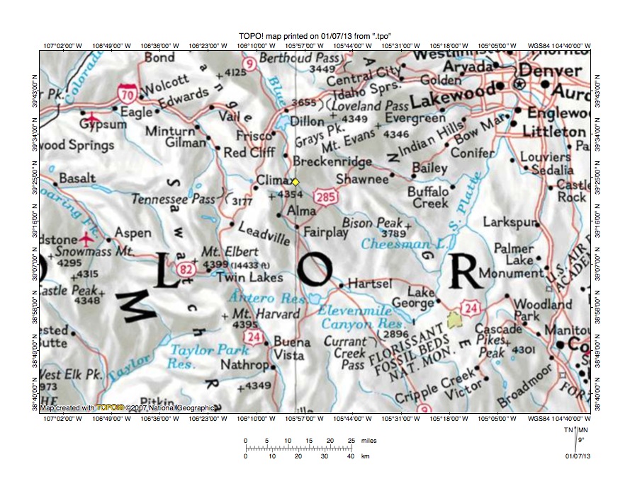
Figure 1: Middle Fork South Platte River-Arkansas River drainage divide area location map (select and click on maps to enlarge). National Geographic Society map digitally presented using National Geographic Society TOPO software.
Figure 1 provides a location map for the Middle Fork South Platte River-Arkansas River drainage divide area in Lake, Park, and Chaffee Counties, Colorado and illustrates a region in central Colorado. The Colorado River flows in a southwest direction across the northwest corner of figure 1. West of figure 1 the Colorado River eventually reaches the Pacific Ocean. The unlabeled Colorado River tributary flowing in a north, northwest, and west direction from near Tennessee Pass to Red Cliff, Gilman, Minturn, Edwards, Eagle, and Gypsum is the Eagle River. The East Fork Eagle River originates near Climax and flows in a west-northwest direction to join the Eagle River. The Blue River originates east of Climax and flows in a north direction to Breckenridge and Dillon before turning in a north-northwest direction to flow to the north edge of figure 1 and then to join the southwest oriented Colorado River. The Middle Fork South Platte River originates south of the Blue River headwaters and flows in a south and southeast direction to Hartsel where it is joined by South Fork South Platte River to form the southeast oriented South Platte River, which then flows to Elevenmile Canyon Reservoir. At the southeast end of Elevenmile Canyon Reservoir the South Platte River makes an abrupt turn to flow in a north-northeast direction to Denver and the north edge of figure 1. North of figure 1 the South Platte River flows in a north and northeast direction before making another abrupt turn to flow in a southeast direction before turning again in a northeast direction to flow into western Nebraska to the Nebraska Platte River, which then flows in an east direction to the south, east, and southeast oriented Missouri River, which then flows to the south oriented Mississippi River. The Arkansas River originates just south of Tennessee Pass and flows in a south-southeast and south direction to Buena Vista and the south center edge of figure 1. South of figure 1 the Arkansas River turns to flow in an east-northeast and then a southeast direction and eventually joins the Mississippi River. The Middle Fork South Platte River-Arkansas River drainage divide area investigated in this essay is located south and west of the Middle Fork South Platte River, east and north of the Arkansas River, and north of the South Fork South Platte River.
Colorado drainage routes developed during immense melt water floods from a thick North American ice sheet at a time when the Colorado mountain ranges were just beginning to emerge. The floodwaters flowed from western Canada to and across Colorado as ice sheet related crustal warping raised the state of Colorado and mountain masses within the state of Colorado and as deep valleys eroded headward into Colorado from the Pacific Ocean in the west and from the Gulf of Mexico in the east to capture the massive south oriented floods. Headward erosion of the south-southeast and southeast oriented Arkansas River valley first captured south oriented flood flow in the region seen in figure 1. The present day north-northeast oriented South Platte River drainage route and its southeast oriented headwaters and tributaries and the north and northwest oriented Colorado River tributaries seen in figure 1 are flowing on alignments of what at one time were south oriented flood flow channels flowing to the newly eroded south-southeast and southeast oriented Arkansas River valley. At that time the deep south and southwest oriented Colorado River valley north of the west half of figure 1 did not exist, nor did the southeast and northeast oriented South Platte River valley exist north of the northeast corner of figure 1. Headward erosion of the deep southwest oriented Colorado River valley captured south oriented flood flow channels and floodwaters on north and northwest ends of beheaded flood flow channels reversed flow direction to flow to the much deeper Colorado River valley and to create north, northwest, and west oriented Colorado River tributary drainage routes. At approximately the same time headward erosion of the deep southeast and northeast oriented South Platte River valley from western Nebraska captured south oriented flood flow channels on the Colorado Piedmont (north and east of Denver) and floodwaters on north ends of the beheaded flood flow channels reversed flow direction to flow to the deeper southeast and northeast oriented South Platte River valley and to create north oriented South Platte River tributary drainage routes and the north-northeast and north oriented South Platte River drainage route seen in figure 1. The flood flow captures and reversals were probably greatly aided by crustal warping that occurred as floodwaters flowed across the region,
Detailed location map for Middle Fork South Platte River-Arkansas River drainage divide area

Figure 2: Detailed location map Middle Fork South Platte River-Arkansas River drainage divide area. United States Geological Survey map digitally presented using National Geographic Society TOPO software.
Figure 2 provides a detailed location map for the Middle Fork South Platte River-Arkansas River drainage divide area in Lake, Park, and Chaffee Counties, Colorado. Green colored areas are National Forest lands, which in Colorado are usually located in mountain regions. County lines are shown and frequently in this region are located along major drainage divides and Lake and Park Counties are labeled. Chaffee County is located in the southwest corner of figure 2 (south of Lake County). Eagle County is north and west of Lake County and Summit County is located east of Eagle County (in north center area of figure 2). Tennessee Pass is located where the north-to-south oriented highway and railroad cross the Eagle-Lake County line. The Eagle River flows in a north and north-northwest direction from Tennessee Pass to the north edge of figure 2 (west half). North of figure 2 the Eagle River turns to flow in a northwest and west direction to join the southwest oriented Colorado River. The Arkansas River originates on the south side of Tennessee Pass and flows in a south-southeast direction to the south edge of figure 2 (west of center). South of figure 2 the Arkansas River turns to flow in an east-northeast and then in a a southeast direction and eventually reaches the south oriented Mississippi River. The East Fork Arkansas River flows in a south-southwest direction from near Climax (in northeast corner of Lake County) to join the south-southeast oriented Arkansas River. Fourmile Creek is a south oriented tributary joining the Arkansas River near Buena Vista. Hoosier Pass is located east of Climax on the Summit-Park County line. The Blue River originates on the north side of Hoosier Pass and flows in a north direction to the north edge of figure 2 (west of center). North of figure 2 the Blue River flows in a north and north-northwest direction to join the southwest oriented Colorado River as a barbed tributary. The Middle Fork South Platte River originates on the south side of Hoosier Pass and flows in a south and southeast direction to Alma and Fairplay before joining the South Fork South Platte River at Hartsel to form the southeast oriented South Platte River. The South Platte River flows in a southeast direction from Hartsel to Elevenmile Canyon Reservoir and then turns to flow in a north-northeast direction across the southeast corner of figure 2. East and north of figure 2 the South Platte River flows in a north-northeast and north direction before turning in a southeast and then northeast direction to flow into western Nebraska. The South Fork South Platte River flows in a southeast and south direction to Antero Reservoir and then in an east, north, and east direction to join the Middle Fork at Hartsel and to form the southeast oriented South Platte River. A second Fourmile Creek originates north of the South Fork South Platte River headwaters and flows in an east and south-southeast direction to join the South Fork South Platte River near Hartsel. Note how drainage routes in Eagle and Summit Counties are oriented in north directions while drainage routes in Lake, Chaffee, and Park County, with the exception of the north-northeast oriented South Platte River segment, are oriented in south and southeast directions.
Tenmile Creek-East Fork Arkansas River drainage divide area

Figure 3: Tenmile Creek-East Fork Arkansas River drainage divide area. United States Geological Survey map digitally presented using National Geographic Society TOPO software.
Figure 3 provides a topographic map of Tenmile Creek-East Fork Arkansas River drainage divide area. The map contour interval for figure 3 is 50 meters. The east-west continental divide is shown with a labeled dashed line extending from Tennessee Pass near the west center edge of figure 3 to Hoosier Pass (just south of the east center edge of figure 3). The Arkansas River originates on the south side of Tennessee Pass and flows in a south direction along and across the west edge of figure 3 to the southwest corner of figure 3 with water eventually reaching the Gulf of Mexico. Mount Arkansas is located in the south center area of figure 3. The north, northwest, southwest, south and southwest oriented drainage route originating east of Mount Arkansas and flowing to the south edge of figure 3 is the East Fork Arkansas River, which joins the Arkansas River south of figure 3. The Eagle River originates on the north side of Tennessee Pass and flows in a north direction to the northwest corner of figure 3. North and west of figure 3 the Eagle River flows in a northwest and west direction to join the southwest oriented Colorado River, which eventually reaches the Pacific Ocean. The northwest oriented stream flowing from near Robinson Lake to join the Eagle River at Eagle Park in the northwest corner of figure 3 is the East Fork Eagle River. The north oriented stream originating on the north side of Hoosier Pass is the Blue River, which flows to the east edge of figure 3 (north half). East and north of figure 3 the Blue River flows in a north, northwest, and west direction to join the southwest oriented Colorado River as a barbed tributary. The north-northeast oriented drainage route crossing the north center edge of figure 3 near the highway is Tenmile Creek, which north of figure 3 flows to the north-northwest oriented Blue River. The Middle Fork South Platte River flows in a south direction on the south side of Hoosier Pass to the south edge of figure 3 (near southeast corner). South of figure 3 the Middle Fork turns to flow in a south-southeast direction to join the southeast and north-northeast oriented South Platte River with water eventually reaching the Gulf of Mexico. Tennessee Pass is approximately 800 meters deep and links the north oriented Eagle River valley with the south oriented Arkansas Valley. Hoosier Pass is approximately 550 meters deep and links the north oriented Blue River valley with the south oriented Middle Fork South Platte River valley. Figure 3 shows three other significant passes linking these deep through valleys. A north-to-south oriented pass south of Robinson Lake links the northwest oriented East Fork Eagle River valley with the south and southwest oriented East Fork Arkansas River valley. Fremont Pass is located near the town of Climax and links the north oriented Tenmile Creek valley with the southwest, south, and southwest oriented East Fork Arkansas River valley. Robinson Lake is located in a west-to-east oriented through valley linking the northwest oriented East Fork Eagle River valley with the north-northeast oriented Tenmile Creek valley. The four north-to-south oriented passes were eroded by south oriented flood flow channels prior to headward erosion of the southwest oriented Colorado River valley north of figure 3. Headward erosion of the deep southwest oriented Colorado River valley beheaded the south oriented flood flow channels in sequence from west to east. Floodwaters on north ends of the beheaded flood flow channels reversed flow direction to flow in north and northwest directions to the much deeper Colorado River valley. Because flood flow channels were anastomosing (diverging and converging) newly reversed flood flow channels could capture yet to be beheaded south oriented flood flow channels further to the east. The newly reversed flood flow channel on the Eagle River alignment captured south oriented flood flow on the Tenmile Creek alignment and the captured flood flow made a U-turn in the Robinson Lake through valley to flow in a northwest direction on the East Fork Eagle River alignment. Headward erosion of the southwest oriented Colorado River valley subsequently beheaded and reversed flood flow on the Blue River-Tenmile Creek alignment to create the north oriented Tenmile Creek-Blue River drainage route (and the east-west continental divide). The flood flow reversals were probably greatly aided by crustal warping that was raising mountains in the region seen in figure 3.
Detailed map of East Fork Eagle River-East Fork Arkansas River drainage divide area
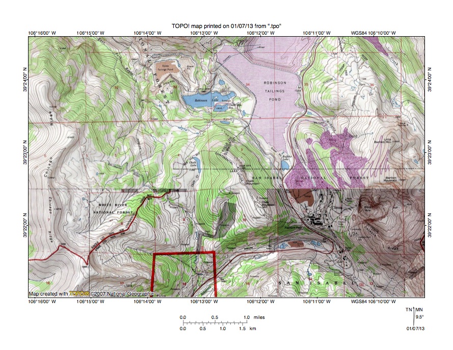
Figure 4: Detailed map of East Fork Eagle River-East Fork Arkansas River drainage divide area. United States Geological Survey map digitally presented using National Geographic Society TOPO software.
Figure 4 provides a detailed topographic map of the East Fork Eagle River-East Fork Arkansas River drainage divide area seen in less detail in figure 3. The map contour interval for figure 4 is 40 feet. The east-west continental divide follows the Eagle-Lake County line from the west edge of figure 4 (south half) to near the center of figure 4 and then follows the Summit-Lake County line to the east edge of figure 4 (near southeast corner). The East Fork Eagle River originates in the southwest quadrant of figure 4 and flows in a northeast, north, and north-northwest direction to the north edge of figure 4 (west half). North and west of figure 4 the East Fork flows to the north, northwest, and west oriented Eagle River, which flows to the southwest oriented Colorado River. Robinson Lake is located in the north center area of figure 4 and the Robinson Tailing Pond is located east and north of Robinson Lake. The unlabeled tailing pond north of the Robinson Tailing Pond is the Tenmile Trailing Pond, which is filling the north-northeast oriented Tenmile Creek valley. North of figure 4 Tenmile Creek flows in a north direction to join the north-northwest oriented Blue River, which then flows to the southwest oriented Colorado River as a barbed tributary. The northwest and southwest oriented drainage route south of the continental divide is the East Fork Arkansas River. South of figure 4 the East Fork flows in a south and southwest direction to join the south oriented Arkansas River, which eventually flows to the south oriented Mississippi River. Chalk Lake is located in section 4 south of Robinson Lake. Chalk Creek originates at Chalk Lake and flows in a south direction to join the East Fork Arkansas River. Chalk Lake is located in a north-to-south oriented through valley linking the north oriented East Fork Eagle River valley with the south oriented East Fork Arkansas River valley. The through valley floor elevation is between 11,320 and 11,360 feet. Chalk Mountain to the east rises to 12.017 feet and Chicago Ridge to the west rises to 12,700 feet suggesting the through valley is at least 657 feet deep. On the east side of Chalk Mountain Climax is located in a north-to-south oriented through valley (Fremont Pass) linking the north oriented Tenmile Creek valley with the south oriented East Fork Arkansas River valley. Fremont Pass has an elevation of between 11,280 and 11,320 feet. Bartlett Mountain to the east rises to 13,555 feet suggesting Fremont Pass is at least 697 feet deep. Robinson Lake is located in a west-to-east oriented through valley linking the north-northwest oriented East Fork Eagle River valley with the north-northeast oriented Tenmile Creek valley. The through valley has a floor elevation of between 11,040 and 11,080 feet (assuming the original drainage divide was west of Robinson Lake), which suggests the through valley is almost 1000 feet deep and also which suggests the west-to-east oriented through valley is 200 to 300 lower in elevation than the two north-to-south oriented through valleys it links. The north-to-south oriented through valleys were eroded by diverging and converging south oriented flood flow channels prior to headward erosion of the southwest oriented Colorado River valley. Headward erosion of the deep southwest oriented Colorado River valley beheaded and reversed flood flow on the western flood flow channel to create the north-northwest oriented East Fork Eagle River (and Eagle River) drainage route, which then captured south oriented flood flow still moving in the eastern flood flow channel. The captured flood flow made a U-turn in the Robinson Lake through valley to flow in a northwest direction to the newly eroded Colorado River valley. Continued headward erosion of the southwest oriented Colorado next beheaded and reversed flood flow in the eastern flood flow channel to create the north oriented Tenmile Creek (and Blue River) drainage route. The described flood flow captures and reversals were probably greatly aided by crustal warping that was occurring as floodwaters flowed across the region.
Arkansas River-Middle Fork South Platte River drainage divide area
Figure 5: Arkansas River-Middle Fork South Platte River drainage divide area. United States Geological Survey map digitally presented using National Geographic Society TOPO software.
Figure 5 illustrates the Arkansas River-Middle Fork South Platte River drainage divide area south of figure 3 and there is an overlap area with figure 3. The map contour interval for figure 5 is 50 meters. The Mosquito Range is the high mountain ridge extending from the north center edge of figure 5 to the south center edge of figure 5. The Middle Fork South Platte River flows in a south and south-southeast direction across the northeast corner of figure 5. Middle Fork South Platte River tributaries originating in the Mosquito Range include Buckskin Creek, Mosquito Creek, Pennsylvania Creek, and Sacramento Creek, all of which flow in southeast and east directions to reach the south-southeast oriented Middle Fork South Platte River (South Mosquito Creek flows in a northeast direction to reach Mosquito Creek). Fourmile Creek flows in an east-northeast and south-southeast direction to the southeast corner of figure 5 and south and east of figure 5 flows to the east oriented South Fork South Platte River, which then joins the Middle Fork South Platte River to form the southeast and north-northeast oriented South Platte River. The Arkansas River can just barely be seen flowing in a south-southeast across the southwest corner of figure 5. The East Fork Arkansas River flows in a southwest direction from the north edge of figure 5 (west of center) to the west edge of figure 5 (north half) and joins the south oriented Arkansas River west of figure 5. Birdseye Gulch originates east of Prospect Mountain and drains in a north and northwest direction to join the East Fork Arkansas River tributary near the north edge of figure 5. Evans Gulch originates near Mountain Lake and drains in a west direction to join the East Fork Arkansas River north of Leadville. A north-to-south oriented gap (pass or through valley) links the north and northwest oriented Birdseye Gulch valley with the east oriented Evan Gulch valley. The gap floor elevation is between 3650 and 3700 meters. Prospect Mountain rises to 3845 meters and the Mosquito Range rises to more than 4000 meters suggesting the gap is at least 145 meters deep. The gap was eroded by south oriented flood flow prior to headward erosion of the southwest oriented East Fork Arkansas River valley. Headward erosion of the southwest oriented East Fork Arkansas River valley beheaded and reversed the south oriented flood flow channel to create the north and northwest oriented Birdseye Gulch drainage route. Similar gaps can be seen on both sides of the Mosquito Range. These gaps provide evidence of south oriented flood flow channels prior to the erosion of the much deeper south oriented Eagle River-Arkansas River and Blue River-Middle Fork South Platte River flood flow channels. Erosion of the much deeper south oriented flood flow channels proceeded from south to north and as tributary valleys eroded headward from each of the deeper flood flow channels to capture south oriented flood flow still flowing along and adjacent to the emerging Mosquito Range mountain ridge.
Fourmile Creek-South Fork South Platte River drainage divide area

Figure 6: Fourmile Creek-South Fork South Platte River drainage divide area. United States Geological Survey map digitally presented using National Geographic Society TOPO software.
Figure 6 provides a detailed topographic map of the Fourmile Creek-South Fork South Platte River drainage divide area south and east of figure 5 and includes an overlap area with figure 5. The map contour interval for figure 6 is 50 meters. The Mosquito Range crest ridge is located along the west edge of figure 6. The narrow ridge labeled “Hill” near the northeast corner of figure 6 is Red Hill, which is a hogback ridge. The Middle Fork South Platte River flows in a south and south-southeast direction from the north edge of figure 6 to the east edge of figure 6 along the west side of Red Hill. The south-southeast oriented “Creek” on the east side of Red Hill is Trout Creek, which joins the Middle Fork South Platte River east of figure 6. The South Fork South Platte River flows in a south-southeast direction from Weston Pass to near the south edge of figure 6 and then turns in an east-northeast and east-southeast direction to flow to the south edge of figure 6 (east of center). South of figure 6 the South Fork South Platte River turns to flow in a south, east, north, and east direction to join the Middle Fork and to form the southeast oriented South Platte River. Fourmile Creek originates in the Mosquito Range near the northwest corner of figure 6 and flows in an east-northeast, southeast, east-northeast, southeast, south, and southeast direction to the east edge of figure 6 (between Middle Fork South Platte River and southeast corner). Weston Pass is located near the west center edge of figure 6. East and south of figure 6 Fourmile Creek joins the South Fork South Platte River just before the South Fork joins the Middle Fork. Sheen Creek and Twelvemile Creek are east and south-southeast oriented South Fork South Platte River tributaries originating south of the east-northeast oriented Fourmile Creek headwaters and joining the South Fork South Platte River near the south center edge of figure 6. A 150 to 200 meter deep gap west of Sheep Mountain links the east-northeast oriented Fourmile Creek valley with the south-southeast oriented Sheen Creek valley. The gap was probably by south-southeast flood flow prior to headward erosion of the deep east-northeast oriented Fourmile Creek valley. Some of the south and south-southeast oriented valley orientations in figure 6 are probably defined by underlying geologic structures, although the valleys are water-eroded valleys. The dominance of south-southeast oriented drainage routes in figure 6 supports the previous interpretation that region was deeply eroded by south and south-southeast oriented flood flow as the Mosquito Range emerged.
Arkansas River-South Fork South Platte River drainage divide area
Figure 7: Arkansas River-South Fork South Platte River drainage divide area. United States Geological Survey map digitally presented using National Geographic Society TOPO software.
Figure 7 illustrates the Arkansas River-South Fork South Platte River drainage divide area south and west of figure 6 and includes an overlap area with figure 6. The map contour interval for figure 7 is 50 meters. The south end of the Mosquito Range can be seen in the north center area of figure 7. The Arkansas River flows in a south-southeast direction from near the northwest corner of figure 7 to the south edge of figure 7 (west half). Weston Pass is located near the center of figure 7. Big Union Creek originates on the north side of Weston Pass and flows in a north-northwest, west, and southwest direction to join the south oriented Arkansas River. The South Fork South Platte River originates on the south side of Weston Pass and flows in a south-southeast and east-northeast direction to the east edge of figure 7 (south half). East of figure 7 the South Fork South Platte River flows in an east, south, east, north, and east direction to join the Middle Fork and to form the southeast and north-northeast oriented South Platte River. Fourmile Creek flows in a south-southeast direction across the northeast corner of figure 7 and joins the South Fork South Platte River east and south of figure 7. Weston Pass has an elevation of 3634 meters. South Peak to the west has an elevation greater than 3900 meters and the elevations in the Mosquito Range to the east are even greater suggesting Weston Pass is at least 250 meters deep. The Arkansas River crosses the 2800-meter contour line west of Weston Pass and is approximately 834 meters deeper than Weston Pass. Yet Weston Pass is a water-eroded valley and was eroded by a south-southeast oriented flood flow channel that diverged from a south-southeast oriented flood flow channel on the Arkansas River alignment. The diverging flood flow channel moved floodwaters to the south-southeast oriented South Fork South Platte River headwaters valley and was captured by headward erosion of the east-northeast oriented South Fork Platte River valley seen near the southeast corner of figure 7. At that time the South Platte River probably flowed in a southeast and direction to ultimately converge with the south-southeast oriented flood flow channel on the Arkansas River alignment. Since that time headward erosion of an 800-meter deep valley along the flood flow channel on the Arkansas River alignment beheaded and reversed the diverging flood flow channel to create the north-northwest and west oriented Big Union Creek drainage route.
Detailed map of Big Union Creek-South Fork South Platte River drainage divide area
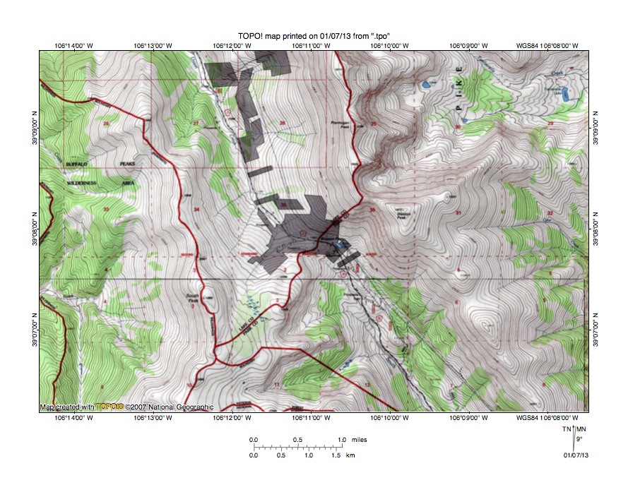
Figure 8: Detailed map of Big Union Creek-South Fork South Platte River drainage divide area. United States Geological Survey map digitally presented using National Geographic Society TOPO software.
Figure 8 provides a detailed topographic map of the Big Union Creek-South Fork South Platte River drainage divide area seen in less detail in figure 7. The map contour interval for figure 8 is 40 feet. Weston Pass is located in the southeast corner of section 35 (near center of figure 8). The north-northwest oriented stream on the north side of Weston Pass is Big Union Creek. North of figure 8 Big Union Creek turns to flow in a west and southwest direction to join the south-southeast oriented Arkansas River. The south-southeast oriented drainage route on the south side of Weston Pass is the South Fork South Platte River. South of figure 8 the South Fork South Platte River flows in an east-northeast, east, south, east, north, and east direction to join the Middle Fork and to form the southeast and north-northeast oriented South Platte River. Weston Pass has an elevation of 11,921 feet. South Peak to the west reaches an elevation of 12,892 feet and Weston Peak to the east reaches 13,572 feet suggesting Weston Pass is approximately 1000 feet deep. Weston Pass is a water-eroded landform and was eroded by a south-southeast oriented flood flow channel that diverged from a south oriented flood flow channel on the present day Arkansas River alignment and then converged with southeast oriented flood flow on the present day southeast oriented South Platte River alignment. At that time the floor of the Arkansas River valley (west of figure 8) was approximately equal in elevation to the floor of Weston Pass. Today the floor of the Arkansas River valley west of figure 8 is approximately 1700 feet lower than the floor of Weston Pass. Headward erosion of a much deeper valley along the Arkansas River alignment beheaded and reversed the diverging flood flow channel to the South Fork South Platte headwaters valley and created the north-northwest and west oriented Big Union Creek drainage route.
South Fork South Platte River-Arkansas River drainage divide area

Figure 9: South Fork South Platte River-Arkansas River drainage divide area. United States Geological Survey map digitally presented using National Geographic Society TOPO software.
Figure 9 illustrates the South Fork South Platte River-Arkansas River drainage divide area south and east of figure 7 and includes an overlap area with figure 7. The map contour interval for figure 9 is 50 meters. The Arkansas River flows in a south-southeast direction from near the northwest corner of figure 9 to the south edge of figure 9 (west half). Low Pass Gulch is a southwest oriented Arkansas River tributary in the northwest quadrant of figure 9. The South Fork South Platte River flows in a south-southeast, east-northeast, and east direction from the north center edge of figure 9 to the east edge of figure 9 (north half). East of figure 9 the South Fork South Platte River flows in a south, east, north, and east-southeast direction to join the south-southeast oriented Middle Fork and to form the southeast and north-northeast oriented South Platte River. Rich Creek flows in a north and east direction across the north center area of figure 9 to join the South Fork South Platte River at the elbow of capture where the South Fork turns from flowing in a south-southeast direction to flowing in an east-northeast direction. Rough and Tumbling Creek originates in a the south center area of figure 9 and flows in a north and northeast direction to join the South Fork South Platte River near the northeast corner of figure 9. South of the north oriented Rough and Tumbling Creek headwaters is the south oriented valley of Fourmile Creek (this is a different Fourmile Creek than the Fourmile Creek seen further to the north in figures 5 and 7). South of figure 9 Fourmile Creek flows to the south-southeast oriented Arkansas River. A north-to-south oriented through valley links the south oriented Fourmile Creek valley, the north oriented Rough and Tumbling Creek valley segment, the north oriented Rich Creek valley segment, and the southwest oriented Low Pass Gulch headwaters valley. The through valley segments are defined by two or more contour lines on a side suggesting the through valley is at least 50 meters deep. The through valley orientation may be related to an underlying geologic structure, but the through valley is also a water-eroded valley and provides evidence of a south-southeast oriented flood flow channel that flowed across the region prior to headward erosion of the deep south-southeast oriented Arkansas River valley and its southwest oriented Low Pass Gulch tributary valley. The through valley floor elevation south of the north oriented Rich Creek headwaters is between 3500 and 3550 meters. The Arkansas River valley floor elevation near Clear Creek Reservoir to the west is less than 2700 meters, which suggests the Arkansas River valley has been lowered by approximately 800 meters since the time south oriented floodwaters flowed in the through valley to the south oriented Fourmile Creek valley. Headward erosion of the South Fork South Platte River valley and its east oriented Rich Creek tributary valley beheaded and reversed flood flow in the through valley to create the north oriented Rich Creek headwaters drainage route and probably reversed southwest and south oriented flood flow on the present day north and northeast oriented Rough and Tumbling Creek alignment. Headward erosion of the much deeper Arkansas River valley and the South Fork South Platte River valley beheaded flood flow to the south oriented Fourmile Creek valley, which then ceased to erode headward leaving a 500-meter deep abandoned south oriented headcut as evidence.
Detailed map of Rough and Tumbling Creek-Fourmile Creek drainage divide area

Figure 10: Detailed map of Rough and Tumbling Creek-Fourmile Creek drainage divide area. United States Geological Survey map digitally presented using National Geographic Society TOPO software.
Figure 10 provides a detailed topographic map of the Rough and Tumbling Creek-Fourmile Creek drainage divide area seen in less detail in figure 9. The map contour interval for figure 10 is 40 feet. The steep west-facing slope along the west edge of figure 10 is the east wall of the deep south-southeast oriented Arkansas River valley. The south oriented stream originating near the center of figure 10 and flowing to the south center edge of figure 10 is Fourmile Creek. South of figure 10 Fourmile Creek flows in a south direction to eventually join the south-southeast oriented Arkansas River. The north-northeast oriented stream in section 18 and flowing to the north edge of figure 10 is Rough and Tumbling Creek. North of figure 10 Rough and Tumbling Creek flows in a north and northeast direction to join the South Fork South Platte River, which flows to the southeast and north-northeast South Platte River. A 300-foot deep or deeper north-to-south oriented through valley in the center of figure 10 links the north oriented Rough and Tumbling Creek valley with the south oriented Fourmile Creek valley. The through valley floor elevation is between 11,400 and 11,440 feet. An even deep through valley in section 24 links the north oriented Rough and Tumbling Creek headwaters valley with both the south oriented Fourmile Creek valley and a west oriented tributary valley draining to the south oriented Arkansas River valley. This deeper through valley has a floor elevation of between 11,320 and 11,360 feet. These through valleys were eroded by south oriented food flow moving to what were deep and parallel south oriented valleys eroding headward on the present day south oriented Fourmile Creek and Arkansas River alignments. Depths of the two valleys eroding headward can be determined by looking at the depth of Fourmile Creek valley. Fourmile Creek crosses the 10,400-foot contour line near the south center edge of figure 10 and crosses the 8400-foot contour line before entering the Arkansas River valley. This evidence suggests two parallel valleys approximately 3000 feet deep were eroding headward along the routes of two converging south oriented flood flow channels. Apparently headward erosion of the Arkansas River valley was proceeding slightly faster than headward erosion of the Fourmile Creek valley until headward erosion of the South Fork South Platte River valley beheaded and reversed flood flow to create the north and northeast oriented Rough and Tumbling Creek drainage route and to end flood flow to the south oriented Fourmile Creek valley.
Additional information and sources of maps studied
This essay has provided only a sample of the detailed topographic map evidence supporting the flood erosion interpretation. Many additional illustrations could be provided. Readers are encouraged to look at mosaics of detailed topographic maps to see the abundance of available data. Maps used in this study were created and published by the United States Geologic Survey and can be obtained directly from the United States Geological Survey and/or from dealers offering United States Geological Survey maps. Hard copy maps can also be observed at United States Geological Survey map depositories, which are located throughout the United States and elsewhere. Illustrations used here were created using National Geographic Society TOPO software and digital map data. TOPO software and map data can be obtained from the National Geographic Society and/or dealers offering National Geographic Society digital map data.

Leave a comment