
Abstract:
This essay uses topographic map evidence to interpret landform origins in the Blue River-South Platte River drainage divide area along the east-west continental divide. The Blue River originates on the north side of Hoosier Pass and flows in a north and north-northwest direction to join the southwest oriented Colorado River. Indiana Creek originates on the northwest side of Boreas Pass and flows in a northwest direction to join the Blue River. The Swan River originates on the north side of Georgia Pass and flows in a north, northwest, and west direction to join the Blue River. The Snake River originates on the north side of Webster Pass and flows in a north and west direction to join the Blue River. The Middle Fork South Platte River flows in a south and southeast direction from Hoosier Pass to the join the southeast and north-northeast oriented South Platte River. North Tarryall Creek flows in a south-southeast direction from Boreas Pass to join southeast and south-southeast oriented Tarryall Creek, which then joins the north-northeast South Platte River as a barbed tributary. Michigan Creek flows in a south-southeast direction from Georgia Pass to join southeast and south-southeast oriented Tarryall Creek. The North Fork South Platte River flows in a southeast, east, northeast and southeast direction from Webster Pass to join the north-northeast oriented South Platte River as a barbed tributary. Orientations of these and other valleys and the associated passes crossing the east-west continental divide can be seen on detailed topographic maps. The valleys and the passes linking opposing valley on opposite sides of the present day east-west continental divide are interpreted to have been eroded by diverging and converging south and southeast oriented flood flow channels at a time when Colorado mountain ranges were emerging. Floodwaters were derived from the western margin of a thick North American ice sheet and flowed from western Canada to and across Colorado to reach what at that time was a newly eroded southeast oriented Arkansas River valley. Ice sheet related crustal warping raised the Colorado mountain ranges as floodwaters flowed across them and as deep valleys eroded headward into the region. Headward erosion of the deep southwest oriented Colorado River valley beheaded and reversed south and southeast oriented flood flow channels to create the north and north-northwest oriented Blue River drainage route and its north, northwest, and west oriented tributary drainage routes. Headward erosion of the deep southeast and northeast oriented South Platte River valley into the Colorado Piedmont from western Nebraska beheaded and reversed south oriented flood flow channels on the Colorado Piedmont to create the north-northeast and north oriented South Platte River drainage route, which captured southeast and south-southeast oriented flood flow channels that had been moving floodwaters to the newly eroded southeast oriented Arkansas River valley.
Preface
The following interpretation of detailed topographic map evidence is one of a series of essays describing similar evidence for all major drainage divides contained within the Missouri River drainage basin and for all major drainage divides with adjacent drainage basins. The research project is interpreting evidence in the context of a previously unexplored deep glacial erosion paradigm, which is fundamentally different from most commonly accepted North American glacial history interpretations. Project essays are listed on the sidebar category list under their appropriate Missouri River tributary drainage basin, Missouri River segment drainage basin (by state), and/or state in which the Missouri River drainage basin is located.
Introduction
The purpose of this essay is to use topographic map interpretation methods to explore the Blue River-South Platte River drainage divide area landform origins along the east-west continental divide. Map interpretation methods can be used to unravel many geomorphic events leading up to formation of present-day drainage routes and development of other landform features. While each detailed topographic map feature provides detailed evidence to be explained, the solution must be consistent with explanations for adjacent area map evidence as well as solutions to big picture map evidence puzzles. I invite readers to improve upon my solutions and/or to propose alternate solutions that better explain evidence and are also consistent with adjacent map area and big-picture evidence. Readers may do so either by making comments here or by writing and publishing their own essays and then by leaving a link to those essays in a comment here.
This essay is also exploring a new geomorphology paradigm in which erosional landforms are interpreted as evidence left by immense glacial melt water floods. Implied in that interpretation is the immense floods were derived from a thick North American ice sheet that created a deep “hole” in the North American continent and also melted fast. The previously unexplored paradigm being tested in this and other Missouri River drainage basin landform origins research project essays is a thick North American ice sheet, comparable in thickness to the Antarctic ice sheet, occupied the North American region usually recognized to have been glaciated, and through its weight and erosive actions created a deep North American “hole”. The southwestern rim of that deep “hole” is today preserved in the high Rocky Mountains. The ice sheet through its weight and deep erosion (and perhaps deposition along major south-oriented melt water flow routes) caused significant crustal warping and tectonic change, through its action of melting fast produced immense floods that flowed across the continent, and through its action of melting fast systematically opened up space in the ice sheet created “hole” so headward erosion of newly developed north-oriented drainage systems captured immense south-oriented melt water floods and diverted immense melt water floods north into space the ice sheet had once occupied.
If this previously unexplored paradigm is correct the geographic region explored by this essay should contain evidence of immense floods that were captured by headward erosion of new valley systems so as to cause the floods to flow in a different direction. Ability of this previously unexplored paradigm to explain Blue River-South Platte River drainage divide area landform evidence along the east-west continental divide will be regarded as evidence supporting the “thick ice sheet that melted fast” paradigm.
Blue River-South Platte River drainage divide area location map

Figure 1: Blue River-South Platte River drainage divide area location map (select and click on maps to enlarge). National Geographic Society map digitally presented using National Geographic Society TOPO software.
Figure 1 provides a location map for the Blue River-South Platte River drainage divide area along the east-west continental divide and illustrates a region in central Colorado. Rocky Mountain National Park is shown and labeled. The Colorado River originates in the northwest quadrant of Rocky Mountain National Park and flows in a south direction to Lake Granby where it turns to flow in a west and southwest direction to the west edge of figure 1 (south of center) and then to eventually reach the Pacific Ocean. The Blue River is a north and north-northwest oriented Colorado River tributary located near the center of figure 1 and originates south of the town of Breckenridge. The lake on the Blue River near the town of Dillon is Dillon Reservoir. The Middle Fork South Platte River originates just south of the Blue River headwaters (south of Breckenridge) and flows in a southeast direction through the town of Alma to Hartsel where it its joined by the southeast and east oriented South Fork South Platte River to form the southeast oriented South Platte River, which flows to Elevenmile Canyon Reservoir near the south edge of figure 1 (east of center). The South Platte River makes an abrupt turn at Elevenmile Canyon Reservoir to flow in a north-northeast direction to Denver and then to near Greeley where the South Platte River makes another abrupt turn to flow in a southeast direction to the east edge of figure 1 (near northeast corner). East of figure 1 the South Platte River turns again to flow in a northeast direction to western Nebraska where it joins the North Platte River to form the Nebraska Platte River with water eventually reaching the Gulf of Mexico. The unlabeled southeast oriented South Platte River barbed tributary east of Alma and near Bison Peak is Tarryall Creek. The unlabeled southeast, east, southeast, northeast, and southeast oriented tributary flowing through the towns of Shawnee, Bailey, and Buffalo Creek is the North Fork South Platte River. The unlabeled south and south-southeast oriented stream originating near Tennessee Pass and flowing to the south edge of figure 1 is the Arkansas River. The Blue River-South Platte River drainage divide area along the east-west continental divide investigated in this essay is located east of the Blue River segment located south of Dillon Reservoir and includes the headwaters of the North and Middle Forks of the South Platte River.
Colorado drainage routes developed during immense melt water floods from the western margin of a thick North American ice sheet at a time when Colorado mountain ranges were just beginning to emerge. At that time massive melt water floods flowed from western Canada to and across Colorado. Colorado mountain ranges emerged as floodwaters flowed across them, as ice sheet related crustal warping raised the mountain masses and the entire state of Colorado, and as deep valleys eroded headward into Colorado from the Gulf of Mexico in the east and from the Pacific Ocean in the west. At first floodwaters flowed in south directions, but flood flow directions changed as Colorado and Colorado mountain ranges were uplifted and as deep valleys eroded headward into the region. South oriented floodwaters on the present day north oriented Blue River alignment and on the present day north oriented South Platte River alignment (on the Colorado Piedmont) were captured first by headward erosion of the southeast oriented Arkansas River valley. The southeast oriented South Platte River headwaters and Tarryall Creek valleys also eroded headward from the newly eroded southeast oriented Arkansas River valley. Headward erosion of the deep southwest oriented Colorado River valley then captured the south oriented flood flow channel on the Blue River alignment and floodwaters on the north end of the beheaded flood flow channel reversed flow direction to flow to the much deeper southwest oriented Colorado River valley and to create the north and north-northwest oriented Blue River drainage route. At approximately the same time headward erosion of the deep southeast and northeast oriented South Platte River valley captured south oriented flood flow channels on the Colorado Piedmont and floodwaters on north ends of the beheaded flood flow reversed flow direction to flow to the much deeper southeast and northeast oriented South Platte River valley and to create north oriented South Platte River tributary drainage routes and the north oriented South Platte River drainage route. The reversal of flood flow on the Colorado Piedmont also captured southeast oriented flood flow channels that had been flowing to the Arkansas River valley. These captured southeast oriented valleys include the present day North Fork, Middle Fork, and South Fork of the South Platte River, the southeast oriented South Platte River segment near Elevenmile Reservoir, and southeast oriented Tarryall Creek. These flood flow captures and reversals took place as crustal warping was raising the region and mountain ranges in the region and the crustal warping contributed significantly to the flood flow capture and reversal processes.
Detailed location map for Blue River-South Platte River drainage divide area

Figure 2: Detailed location map Blue River-South Platte River drainage divide area. United States Geological Survey map digitally presented using National Geographic Society TOPO software.
Figure 2 provides a detailed location map for the Blue River-South Platte River drainage divide area along the east-west continental divide. Green colored areas are National Forest lands, which in Colorado are usually located in mountain areas. County lines are shown and Summit, Park, and Lake Counties are labeled. Eagle County is west of Summit County and north of Lake County. Eagle and Summit Counties are located on the west side of the east-west continental divide while Park and Lake Counties are located on the east side of the continental divide. Dillon Reservoir is located near the north center edge of figure 2. The Blue River originates near Hoosier Pass at the southern tip of Summit County and flows in a north direction to Dillon Reservoir. North of figure 2 the Blue River flows in a north-northwest direction to join the southwest oriented Colorado River as a barbed tributary. The Middle Fork South Platte River originates near the south side of Hoosier Pass and flows in a south and south-southeast direction to Fairplay and then to join the South Fork near Hartsel (near south edge of figure 2) to form the southeast oriented South Platte River, which south of figure 2 turns to flow in a north-northeast direction. The Swan River originates near the continental divide in Summit County and flows in a north-northwest and west-northwest direction to join the Blue River between Breckenridge and Dillon Reservoir. Michigan Creek is a southeast oriented stream originating on the opposite side of the continental divide from the Swan River headwaters and flows to southeast oriented Tarryall Creek, which flows to the east edge of figure 2 (near southeast corner). East and south of figure 2 Tarryall Creek flows to the north-northeast oriented South Platte River as a barbed tributary. The Snake River in Summit County flows in a north and west direction to join the Blue River at Dillon Reservoir. The north oriented Snake River headwaters appear of figure 2 to be a north oriented tributary originating near Teller Mountain. South of the north oriented Snake River headwaters are headwaters of the southeast, east, southeast, and east oriented North Fork South Platte River, which flows to the east edge of figure 2 (north of center). East of figure 2 the North Fork joins the north oriented South Platte River as a barbed tributary. Drainage routes seen in Park County are almost all oriented in southeast directions while drainage routes in Summit County are oriented primarily in north and northwest directions. The south-southeast oriented drainage route originating in Lake County is the Arkansas River, which south of figure 2 turns to flow in a southeast direction to eventually join the south oriented Mississippi River.
Snake River-North Fork South Platte River drainage divide area
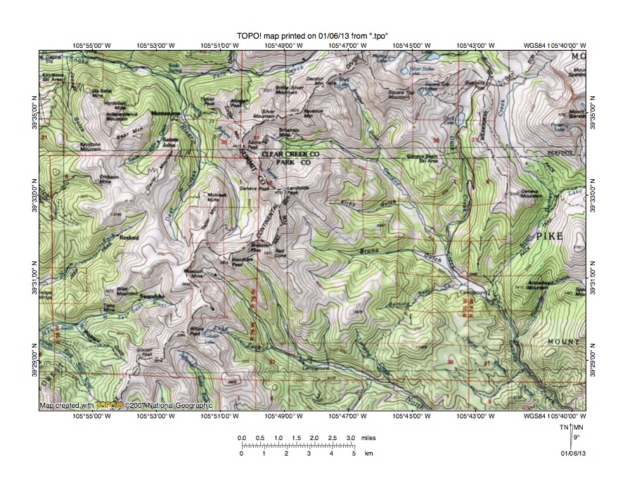
Figure 3: Snake River-North Fork South Platte River drainage divide area. United States Geological Survey map digitally presented using National Geographic Society TOPO software.
Figure 3 provides a topographic map of Snake River-North Fork South Platte River drainage divide area. The map contour interval for figure 3 is 50 meters. The Summit County eastern border follows the continental divide, which is shown with a labeled dashed line extending from the north edge of figure 3 (east of center) to the south edge of figure 3 (near southwest corner). Webster Pass crosses the continental divide near the center of figure 3. The Snake River originates north of Webster Pass and flows in a north and north-northeast direction to near the north edge of figure 3 where it turns in a west direction to flow to the northwest corner of figure 3. West of figure 3 the Snake River joins the north oriented Blue River at Dillon Reservoir with water eventually reaching the Pacific Ocean. The North Fork South Platte River originates on the south side of Webster Pass and flows in a southeast direction to the south edge of figure 3 (east half). South and east of figure 3 the North Fork joins the north oriented South Platte River with water eventually reaching the Gulf of Mexico. Webster Pass has an elevation of between 3650 and 3700 meters. Landslide Peak to the northeast rises to 4035 meters and Whaley Peak to the southwest rises to 3986 meters suggesting Webster Pass could be as much as 300 meters deep. Today Webster Pass is a gap in a high mountain ridge, yet that gap originated as a water-eroded valley at a time when the regional topography looked very different from it does now. At that time the deep Snake River valley to the north did not exist and the high mountain ridges were just beginning to emerge. Diverging and converging south and southeast oriented flood flow channels eroded valleys into those emerging mountain ridges and for a time were able to erode the valleys as fast as the ridges rose. The south and southeast oriented flood flow flowed from the present day north oriented Snake River headwaters valley to the southeast oriented North Fork South Platte River valley. Headward erosion of the deep southwest oriented Colorado River valley (north of figure 3) beheaded and reversed south oriented flood flow channels to create the north, west, and north-northwest oriented Snake River-Blue River drainage route. Guanella Pass is located near the north edge of figure 3 between Mount Bierstadt and Square Top Mountain (near northeast corner) and links the south oriented Duck Creek and Scott Gomer Creek valleys with the north oriented South Clear Creek valley (north of figure 3). North of figure 3 South Clear Creek flows to north and east oriented Clear Creek, which flows to the north oriented South Platte River. North of the Clear Creek elbow of capture is the north and northwest oriented Fraser River valley, which drains to the southwest oriented Colorado River valley. And north of the north oriented Fraser River valley is the south oriented Colorado River headwaters valley in Rocky Mountain National Park. Guanella Pass has an elevation of between 3450 and 3500 meters. Mount Bierstadt rises to 4282 meters and Square Top Mountain rise to more than 4200 meters suggesting Guanella Pass is more than 700 meters deep. Duck Creek and Scott Gomer Creek flow to southeast oriented Geneva Creek, which flows to the southeast corner of figure 3 and which joins the North Fork South Platte River south and east of figure 3. A south oriented flood flow channel that split into two diverging and converging flood flow channels at Guanella Pass eroded the deep gap. The south oriented flood flow channel was first beheaded and reversed by headward erosion of the east oriented Clear Creek valley (north of figure 3-see Colorado River-Clear Creek drainage divide area essay) to create the north oriented South Clear Creek drainage route.
Detailed map of Snake River-North Fork South Platte River drainage divide area

Figure 4: Detailed map of Snake River-North Fork South Platte River drainage divide area. United States Geological Survey map digitally presented using National Geographic Society TOPO software.
Figure 4 provides a detailed topographic map of the Snake River-North Fork South Platte River drainage divide area seen in less detail in figure 3. The map contour interval for figure 4 is 40 feet. The east-west continental divide is shown with a labeled red line extending from the north edge of figure 4 (east half) along the high mountain ridge to the south edge of figure 4 (west half). The unlabeled north oriented drainage route flowing to the north center edge of figure 4 is the headwaters of the Snake River. North of figure 4 the Snake River turns to flow in a west direction to join the north-northwest oriented Blue River, which then flows to the southwest oriented Colorado River. The north oriented stream near the northwest corner of figure 4 is Deer Creek, which north of figure 4 joins the north and west oriented Snake River. The south-southeast oriented drainage route flowing to the south center edge of figure 4 is the North Fork South Platte River. South of figure 4 the North Fork South Platte River flows primarily in a southeast direction, but has some east and northeast stretches before reaching the north oriented South Platte River as a barbed tributary. Handcart Peak is located near the center of figure 4 and Webster Pass is located east and north of Handcart Peak. Webster Pass has an elevation of 12.096 feet. An unnamed peak in section 7 to the northeast of Webster Pass rises to 13,214 feet and Whale Peak (on continental divide just south of figure 4) rises to 13,078 feet suggesting Webster Pass is approximately 1000 feet deep. Today Webster Pass also stands more than 1000 feet above the floors of the adjacent valleys, yet Webster Pass and other unnamed and shallower passes crossing the continental divide in figure 4 are water-eroded landforms. At a time when the high mountain ridges did not exists diverging and converging south and southeast oriented flood flow channels eroded valleys into the emerging continental divide ridge. The south and southeast oriented flood flow was beheaded and reversed by headward erosion of the deep southwest oriented Colorado River valley north of figure 4. Uplift of the mountain ridge probably continued after floodwaters ceased to flow across the region ended. After all flood flow had ended and after crustal warping had produced the high mountains seen today valley glaciers probably deepened and otherwise altered some of the flood-eroded valleys to create the landscape seen today.
South Fork Swan River-Michigan Creek drainage divide area
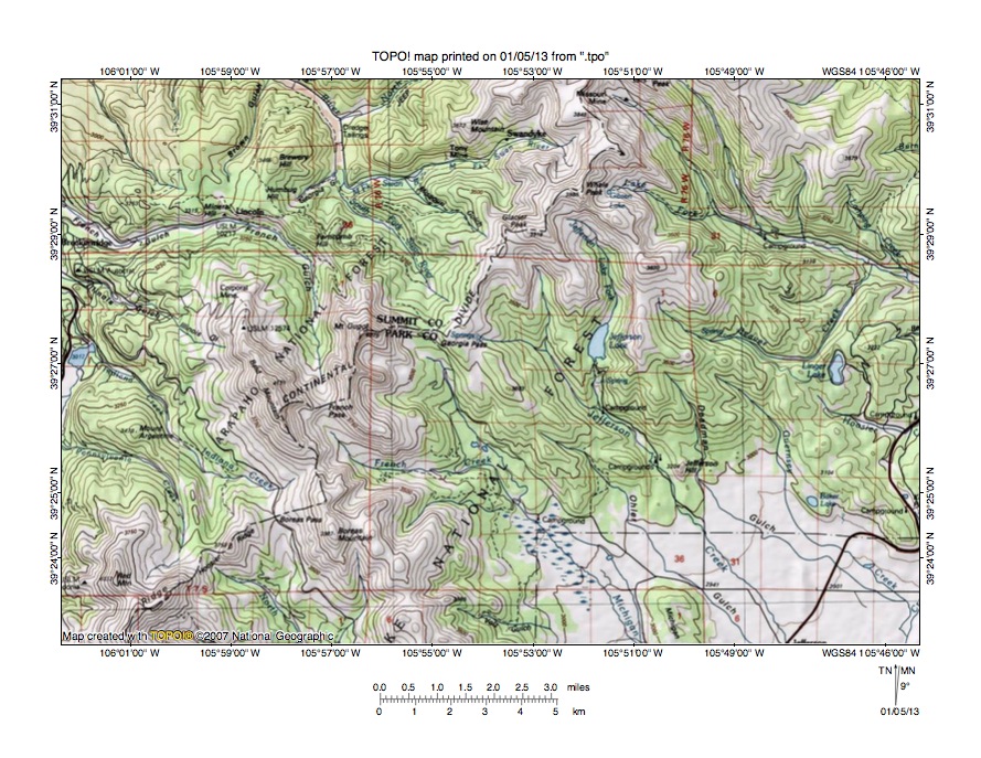
Figure 5: South Fork Swan River-Michigan Creek drainage divide area. United States Geological Survey map digitally presented using National Geographic Society TOPO software.
Figure 5 illustrates the South Fork Swan River-Michigan Creek drainage divide area south and west of figure 3 and there is an overlap area with figure 3. The map contour interval for figure 5 is 50 meters. The east-west continental divide is shown with a labeled dashed line extending from the north edge of figure 5 (east of center) along the crest of the high mountain ridge to the south edge of figure 5 (near southwest corner). Georgia Pass crosses a west-to-east oriented segment of the continental divide near the center of figure 5. The northwest oriented South Fork Swan River originates on the north side of Georgia Pass and then joins the west-southwest oriented Middle Fork Swan River to form the north and northwest oriented Swan River, which flows to the north edge of figure 5 (west half). North of figure 5 the Swan River turns to flow in a west direction to join the north and north-northwest oriented Blue River, which flows to the southwest oriented Colorado River. The south-southeast oriented stream originating on the south side of Georgia Pass is Michigan Creek, which flows to the south edge of figure 5 (east of center). South of figure 5 Michigan Creek joins Tarryall Creek, which then flows in a south-southeast direction to join the north oriented South Platte River as a barbed tributary. Georgia Pass has an elevation of between 3500 and 3550 meters. Whale Peak to the northeast reaches an elevation of 3986 meters and Bald Mountain to the southwest reaches an elevation of 4171 meters suggesting Georgia Pass could be more than 400 meters deep. Georgia Pass provides evidence of what was once a south-southeast oriented flood flow channel, which flowed from the present day north oriented Blue River alignment to the south-southeast Tarryall Creek alignment and then to a south oriented flood flow channel on the present day north oriented South Platte River alignment (with floodwaters probably flowing to what at that time was the newly eroded southeast oriented Arkansas River valley). Headward erosion of the deep southwest oriented Colorado River valley north of figure 5 beheaded and reversed the south-southeast oriented flood flow channel to create the north oriented Swan River and Blue River drainage route. The flood flow reversal was probably greatly aided by crustal warping that was raising the continental divide mountain ridge as floodwaters flowed across the region.
Detailed map of South Fork Swan River-Michigan Creek drainage divide area
Figure 6: Detailed map of South Fork Swan River-Michigan Creek drainage divide area. United States Geological Survey map digitally presented using National Geographic Society TOPO software.
Figure 6 provides a detailed topographic map of the South Fork Swan River-Michigan Creek drainage divide area seen in less detail in figure 5. The map contour interval for figure 6 is 40 feet. The east-west continental divide is shown with a labeled red line extending from the north edge of figure 6 (east half) to the south edge of figure 6 (near southwest corner). Georgia Pass crosses the continental divide in the southwest quadrant of figure 6. The South Fork Swan River originates on the north side of Georgia Pass and flows in a north and northwest direction to the northwest corner of figure 6. North and west of figure 6 the South Fork joins the Middle Fork to form the north, northwest, and west oriented Swan River, which flows to the north and north-northwest oriented Blue River, which flows to the southwest oriented Colorado River. Michigan Lake is a small lake on the south side of Georgia Pass. Michigan Creek flows in a south-southeast direction from Michigan Lake to the south edge of figure 6 (west half). South of figure 6 Michigan Creek joins south-southeast oriented Tarryall Creek, which then joins the north oriented South Platte River as a barbed tributary. Georgia Pass has an elevation of 11,585 feet (511 feet lower than Webster Pass). Mount Guyot near the southwest corner of figure 6 reaches an elevation of 13,270 feet. Glacier Peak in the northeast quadrant of figure 6 reaches an elevation of 12,853 feet and Whale Peak (just north of figure 6) reaches an elevation of 13,078 feet. Depending on which elevations are used Georgia Pass could be approximately 1000 feet deep or it could be almost 1600 feet deep. In either case Georgia Pass is a major water-eroded valley crossing the present day continental divide. When Georgia Pass was eroded the high mountain ridge did not exist nor did the deep valleys north of Georgia Pass exist. Floodwaters flowed in a southeast and south-southeast direction from the present day north oriented Swan River and Blue River alignment to the south-southeast oriented Michigan Creek and Tarryall Creek valley. The south-southeast oriented flood flow channel was beheaded and reversed by headward erosion of the deep southwest oriented Colorado River valley (north of figure 6). Floodwaters on the north-northwest end of the beheaded flood flow channel reversed flow direction to create the north oriented South Fork Swan River, Swan River, and Blue River drainage route. Uplift of the high mountain ridge as floodwaters were flowing across it probably contributed to the flood flow reversal and probably continued after floodwaters ceased to flow across the region. Valley glaciers may have subsequently formed in the uplifted valleys and may have deepened and otherwise altered the valleys.
Indiana Creek-North Tarryall Creek drainage divide area
Figure 7: Indiana Creek-North Tarryall Creek drainage divide area. United States Geological Survey map digitally presented using National Geographic Society TOPO software.
Figure 7 illustrates the Indiana Creek-North Tarryall Creek drainage divide area south and west of figure 5 and includes an overlap area with figure 5. The map contour interval for figure 7 is 50 meters. The east-west continental divide also serves as the Park-Summit County border and extends from the west edge of figure 7 (south half) to the north edge of figure 7 (east half). Hoosier Pass crosses the continental divide near the southwest corner of figure 7. Georgia Pass crosses the continental divide in the northeast quadrant of figure 7. Boreas Pass crosses the continental divide near the center of figure 7. The Blue River originates on the north side of Hoosier Pass and flows in a north direction to the north edge of figure 7 (west half). North of figure 7 the Blue River flows in a north and north-northwest direction to join the southwest oriented Colorado River. Indiana Creek is a northwest oriented Blue River tributary originating near Boreas Pass. The south-southeast oriented stream originating on the south side of Boreas Pass is North Tarryall Creek, which flows to southeast oriented Tarryall Creek. Tarryall Creek then flows to the south edge of figure 7 and south of figure 7 flows in a south-southeast direction to eventually join the north-northeast oriented South Platte River as a barbed tributary. Boreas Pass has an elevation of between 3500 and 3550 meters. Bald Mountain to the north rises to 4171 meters and elevations on Hoosier Ridge to the southwest rise to more than 4050 meters suggesting Boreas Pass may be as much as 500 meters deep. Boreas Pass is one of two deep gaps or notches in Hoosier Ridge with the second gap linking the north and west oriented Pennsylvania Creek valley with the southeast oriented North Tarryall Creek headwaters valley. The second gap is approximately 50 meters shallower than Boreas Pass. These two gaps or passes originated as valleys eroded by diverging and converging south and southeast oriented flood flow channels moving floodwaters from the present day north oriented Blue River alignment to the southeast and south-southeast oriented Tarryall Creek alignment and then probably to what at that time was the newly eroded southeast oriented Arkansas River valley. The two gaps or passes were eroded as floodwaters eroded deeper and deeper valleys into what was a rising mountain ridge. Headward erosion of the deep southwest oriented Colorado River valley north of figure 7 beheaded and reversed the south and southeast oriented flood flow to create the north and north-northwest oriented Blue River drainage route. The flood flow reversal was probably greatly aided by crustal warping that was raising the mountain ridge and the entire region.
Detailed map of Indiana Creek-North Tarryall Creek drainage divide area
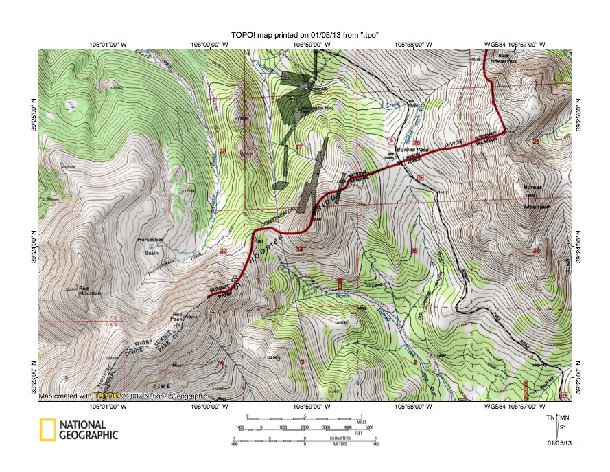
Figure 8: Detailed map of Indiana Creek-North Tarryall Creek drainage divide area. United States Geological Survey map digitally presented using National Geographic Society TOPO software.
Figure 8 provides a detailed topographic map of the Indiana Creek-North Tarryall Creek drainage divide area seen in less detail in figure 7. The map contour interval for figure 8 is 40 feet. The east-west continental divide is shown with a labeled line extending from the south edge of figure 8 (west half) to the north edge of figure 9 (east half). Boreas Pass is located in section 26 in the northeast quadrant of figure 8. Indiana Creek flows in a west direction across the north margin of section 26 and then turns to flow in a north-northwest direction to the north center edge of figure 8. North of figure 8 Indiana Creek flows in a northwest direction to join the north and north-northwest oriented Blue River, which flows to the southwest oriented Colorado River. The south oriented stream originating on the south side of Boreas Pass joins southeast and south-southeast oriented North Tarryall Creek, which flows to the south edge of figure 8 (east half). South of figure 8 North Tarryall Creek joins southeast and south-southeast oriented Tarryall Creek, which eventually joins the north-northeast oriented South Platte River as a barbed tributary. An unnamed pass in the northwest corner of section 34 links a north oriented Indiana Creek tributary valley and the north and northwest oriented Pennsylvania Creek valley with the southeast oriented North Tarryall Creek valley. North of figure 8 Pennsylvania Creek turns in a west direction to join the north oriented Blue River. Boreas Pass has an elevation of 11,481 feet. The unnamed pass has an elevation of between 11,680 and 11,720 feet. Bald Mountain, which is located on the continental divide just north of figure 8, reaches an elevation of 13,679 feet. Hoosier Ridge near the southwest corner of figure 8 reaches an elevation of 13,352 feet. These elevations suggest Boreas Pass is approximately 1900 feet deep and the unnamed pass is approximately 1600 feet deep. These two passes were eroded at a time when two diverging and converging flood flow channels crossed the emerging continental divide ridge. Floodwaters were flowing from the present day north oriented Blue River alignment to the south-southeast oriented Tarryall Creek alignment and then probably to what was at that time the newly eroded southeast oriented Arkansas River valley. The passes were eroded as floodwaters eroded deeper and deeper valleys into the emerging mountain ridge. Uplift of the mountain ridge and region combined with headward erosion of the much deeper southwest oriented Colorado River valley to the north of figure 8 resulted in a flood flow reversal that created the north oriented Blue River drainage routes and its north, northwest, and west oriented Indiana and Pennsylvania Creek drainage routes.
Blue River-Middle Fork South Platte River drainage divide area
Figure 9: Blue River-Middle Fork South Platte River drainage divide area. United States Geological Survey map digitally presented using National Geographic Society TOPO software.
Figure 9 illustrates the Blue River-Middle Fork South Platte River drainage divide area west and slightly south of figure 7 and includes an overlap area with figure 7. The map contour interval for figure 9 is 50 meters. The east-west continental divide is shown with a labeled dashed line extending from the east edge of figure 9 (north half) to the south edge of figure 9 (west of center). Hoosier Pass crosses the continental divide in the east center area of figure 9. The Blue River originates on the north side of Hoosier Pass and flows in a north direction to the north edge of figure 9 (east half). North of figure 9 the Blue River flows in a north and north-northwest direction to join the southwest oriented Colorado River. The south oriented stream south of Hoosier Pass is the Middle Fork South Platte River, which flows in a south direction to the south edge of figure 9 (east half). South of the figure 9 the Middle Fork flows in a southeast direction to join the South Fork and to form the southeast oriented South Platte River, which makes an abrupt turn at Elevenmile Canyon Reservoir to flow in a north-northeast direction. Hoosier Pass has an elevation of 3517 meters. Hoosier Ridge to the northeast and on the continental divide rises to more than 4050 meters and mountains west of Hoosier Pass rise to even higher elevations suggesting Hoosier Pass is more than 500 meters deep. Hoosier Pass was eroded by south oriented floodwaters flowing from the present day north oriented Blue River alignment to the south and southeast oriented Middle Fork South Platte River valley and which were probably flowing to what at that time was the newly eroded southeast oriented Arkansas River valley. Floodwaters were flowing across an emerging mountain region and eroded a deeper and deeper valley into the emerging mountain mass until headward erosion of the much deeper southwest oriented Colorado River valley (north of figure 9) beheaded and reversed the south oriented flood flow to create the north oriented Blue River drainage route. Uplift of the mountain mass continued after flood flow across Hoosier Pass ended. After the mountains had been fully uplifted valley glaciers filled some of the flood eroded valleys and deepened and otherwise altered those valleys. The southwest, south, and southwest stream flowing to the southwest corner of figure 9 is the East Fork Arkansas River. South and west of the figure 9 the East Fork joins the south-southeast and southeast oriented Arkansas River. North oriented streams north of the East Fork Arkansas River headwaters (draining north in the valley filled with tailings ponds) flow to north oriented Tenmile Creek, which is a Blue River tributary. South oriented flood flow on the present day north oriented Blue River alignment diverged north of figure 9 into two south oriented flood flow channels with one flood flow channel leading to the Middle Fork South Platte River valley and the other flood flow channel leading to the East Fork Arkansas River valley.
Detailed map of Blue River-Middle Fork South Platte River drainage divide area

Figure 10: Detailed map of Blue River-Middle Fork South Platte River drainage divide area. United States Geological Survey map digitally presented using National Geographic Society TOPO software.
Figure 10 provides a detailed topographic map of the Blue River-Middle Fork South Platte River drainage divide area seen in less detail in figure 9. The map contour interval for figure 10 is 40 feet. The east-west continental divide is shown with a labeled line extending from near the northeast corner of figure 10 to the west edge of figure 10 (north of center). A north-to-south oriented highway extends from the north edge of figure 10 (slightly west of center) to the south center edge of figure 10 and crosses the continental divide at Hoosier Pass. The north oriented drainage route flowing to the north center edge of figure 10 is the headwaters of the Blue River, which north of figure 10 flows in a north and north-northwest direction to join the southwest oriented Colorado River. The south oriented drainage route flowing to the south edge of figure 10 (south of Hoosier Pass) is the Middle Fork South Platte River. Hoosier Pass has an elevation of 11,539 feet. Hoosier Ridge near the northeast corner of figure 10 rises to 13,352 feet and mountains along the continental divide to the west of Hoosier Pass (and west of figure 10) rise even higher suggesting Hoosier Pass may be as much as 1800 feet deep. Hoosier Pass was eroded by south oriented floodwaters flowing from the present day north oriented Blue River alignment to the present day south and southeast oriented Middle Fork South Platte River valley. Floodwaters were flowing across a rising mountain mass and eroded the Hoosier Pass valley deeper and deeper until the south oriented flood flow channel was beheaded and reversed by headward erosion of the much deeper southwest oriented Colorado River valley to create the north oriented Blue River drainage route. Uplift of the mountain mass continued after flood flow across Hoosier Pass ended. The Blue River valley floor at the north edge of figure 10 has an elevation of approximately 10,400 feet and is more than 900 feet lower than Hoosier Pass. The Middle Fork South Platte River valley floor just south of figure 10 has an elevation of approximately 10,600 feet and is more than 700 feet lower than Hoosier Pass. These elevations suggest there may have been 700 to 900 feet of uplift of the Hoosier Pass ridge after flood flow across Hoosier Pass ceased, although it is more probable the entire mountain mass was being uplifted. In either case, valley glaciers probably formed in the valleys after the mountains and region had been fully uplifted and the glaciers deepened the Blue River and Middle Fork South Platte River valleys, with the Hoosier Pass ridge left between the two opposing glacially deepened valleys.
Additional information and sources of maps studied
This essay has provided only a sample of the detailed topographic map evidence supporting the flood erosion interpretation. Many additional illustrations could be provided. Readers are encouraged to look at mosaics of detailed topographic maps to see the abundance of available data. Maps used in this study were created and published by the United States Geologic Survey and can be obtained directly from the United States Geological Survey and/or from dealers offering United States Geological Survey maps. Hard copy maps can also be observed at United States Geological Survey map depositories, which are located throughout the United States and elsewhere. Illustrations used here were created using National Geographic Society TOPO software and digital map data. TOPO software and map data can be obtained from the National Geographic Society and/or dealers offering National Geographic Society digital map data.

Leave a comment