
Abstract:
This essay uses topographic map evidence to interpret landform origins in the Colorado River-Clear Creek drainage divide area along the east-west continental divide. Berthoud Pass and Vasquez Pass link north oriented valleys draining to the southwest oriented Colorado River with the east oriented Clear Creek valley, which drains to the north oriented South Platte River. Loveland Pass and unnamed passes link the east oriented Clear Creek headwaters valley with the north-northwest oriented Blue River valley, which drains to the southwest oriented Colorado River. Guanella Pass links the north oriented South Clear Creek valley with the southeast oriented North Fork South Platte River. Each of these passes originated as a water-eroded valley at a time when Colorado mountain ranges were just beginning to emerge. The passes were eroded by immense south oriented melt water floods from the western margin of a thick North American ice sheet and floodwaters flowed from western Canada to and across Colorado. Colorado mountain ranges emerged as floodwaters flowed across them, as ice sheet related crustal warping raised the mountain masses and the entire state of Colorado, and as deep valleys eroded headward into Colorado from the Gulf of Mexico in the east and from the Pacific Ocean in the west. Headward erosion of the deep east oriented Clear Creek valley from south oriented flood flow channels on the present day north oriented South Platte River alignment captured south oriented flood flow in the emerging Colorado mountains. Floodwaters on the north end of a beheaded flood flow channel on the present day north oriented South Clear Creek alignment reversed flow direction to flow to the much deeper east oriented Clear Creek valley and to create the present day north oriented South Clear Creek drainage route. Headward erosion of the deep southwest oriented Colorado River valley next beheaded and reversed south and southeast oriented flood flow channels to the newly eroded Clear Creek valley and created north and northwest oriented Colorado River tributary drainage routes as floodwaters reversed flow direction to flow to the much deeper Colorado River valley. Headward erosion of the deep southeast and northeast oriented South Platte River valley from western Nebraska next beheaded and reversed south oriented flood flow channels on the Colorado Piedmont to create the present day north oriented South Platte River drainage route and its north oriented tributary drainage routes. These flood flow captures and reversals took place as crustal warping was raising high mountain ridges and the entire state of Colorado. After flood flow across Colorado had ended and after Colorado mountain ranges had been uplifted valley glaciers filled some of the flood-eroded valleys and deepened and otherwise altered those valleys.
Preface
The following interpretation of detailed topographic map evidence is one of a series of essays describing similar evidence for all major drainage divides contained within the Missouri River drainage basin and for all major drainage divides with adjacent drainage basins. The research project is interpreting evidence in the context of a previously unexplored deep glacial erosion paradigm, which is fundamentally different from most commonly accepted North American glacial history interpretations. Project essays are listed on the sidebar category list under their appropriate Missouri River tributary drainage basin, Missouri River segment drainage basin (by state), and/or state in which the Missouri River drainage basin is located.
Introduction
The purpose of this essay is to use topographic map interpretation methods to explore the Colorado River-Clear Creek drainage divide area landform origins along the east-west continental divide. Map interpretation methods can be used to unravel many geomorphic events leading up to formation of present-day drainage routes and development of other landform features. While each detailed topographic map feature provides detailed evidence to be explained, the solution must be consistent with explanations for adjacent area map evidence as well as solutions to big picture map evidence puzzles. I invite readers to improve upon my solutions and/or to propose alternate solutions that better explain evidence and are also consistent with adjacent map area and big-picture evidence. Readers may do so either by making comments here or by writing and publishing their own essays and then by leaving a link to those essays in a comment here.
This essay is also exploring a new geomorphology paradigm in which erosional landforms are interpreted as evidence left by immense glacial melt water floods. Implied in that interpretation is the immense floods were derived from a thick North American ice sheet that created a deep “hole” in the North American continent and also melted fast. The previously unexplored paradigm being tested in this and other Missouri River drainage basin landform origins research project essays is a thick North American ice sheet, comparable in thickness to the Antarctic ice sheet, occupied the North American region usually recognized to have been glaciated, and through its weight and erosive actions created a deep North American “hole”. The southwestern rim of that deep “hole” is today preserved in the high Rocky Mountains. The ice sheet through its weight and deep erosion (and perhaps deposition along major south-oriented melt water flow routes) caused significant crustal warping and tectonic change, through its action of melting fast produced immense floods that flowed across the continent, and through its action of melting fast systematically opened up space in the ice sheet created “hole” so headward erosion of newly developed north-oriented drainage systems captured immense south-oriented melt water floods and diverted immense melt water floods north into space the ice sheet had once occupied.
If this previously unexplored paradigm is correct the geographic region explored by this essay should contain evidence of immense floods that were captured by headward erosion of new valley systems so as to cause the floods to flow in a different direction. Ability of this previously unexplored paradigm to explain Colorado River-Clear Creek drainage divide area landform evidence along the east-west continental divide will be regarded as evidence supporting the “thick ice sheet that melted fast” paradigm.
Colorado River-Clear Creek drainage divide area location map
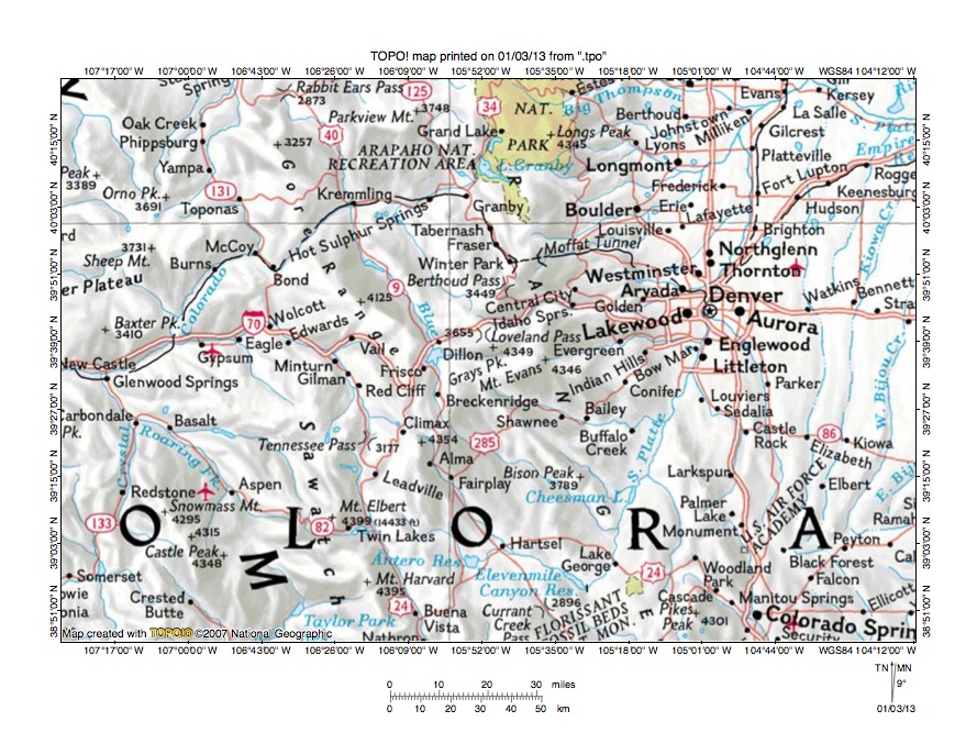
Figure 1: Colorado River-Clear Creek drainage divide area location map (select and click on maps to enlarge). National Geographic Society map digitally presented using National Geographic Society TOPO software.
Figure 1 provides a location map for the Colorado River-Clear Creek drainage divide area along the east-west continental divide and illustrates a region in central Colorado. The green colored area straddling the north edge of figure 1 is Rocky Mountain National Park. The Colorado River originates near the north edge of figure 1 and flows in a south direction along the west side of Rocky Mountain National Park to Lake Granby and then flows in a west-southwest, and southwest direction to the west center edge of figure 1. West of figure 1 the Colorado River eventually reaches the Pacific Ocean. The Blue River is a north and north-northwest oriented tributary originating south of Breckenridge and joining the Colorado River near Kremmling. Loveland Pass is located near the center of figure 1 and Berthoud Pass is north of Loveland Pass. The Fraser River (not shown on figure 1) originates near Berthoud Pass and flows in a north and northwest direction through the towns of Winter Park, Fraser, and Tabernash to join the Colorado River near Granby. The unlabeled north-northwest oriented Colorado River tributary between the Blue River and the Fraser River is Williams Fork. The Middle Fork South Platte River originates south of the Blue River headwaters and flows in a south-southeast direction from Alma to Hartsel where it is joined by the South Fork South Platte River to form the South Platte River. The South Platte River then flows in a southeast direction from Hartsel to Elevenmile Canyon Reservoir where the South Platte River makes an abrupt turn to flow in a north-northeast direction to Denver. The South Platte River flows in a north-northeast direction to the north edge of figure 1 and then makes another abrupt turn to flow in a southeast direction to the east edge of figure 1 (near northeast corner). East of figure 1 the South Platte River turns again to flow in a northeast direction to flow into western Nebraska and to join the Nebraska Platte River with water eventually reaching the Gulf of Mexico. Clear Creek is shown on figure 1, but is not labeled and is difficult to see. Clear Creek originates just north of Loveland Pass and flows in an east, north, and east direction to the towns of Idaho Springs and Golden before joining the South Platte River just north of Denver. The essay focuses on the continental divide section east of the Blue River, south of the Fraser River, and west of Idaho Springs and near the Clear Creek headwaters. The Fraser River-Boulder Creek essay illustrates and describes the continental area north of Berthoud Pass.
Drainage routes in Colorado developed during immense melt water floods from the western margin of a thick North American ice sheet. Floodwaters flowed from western Canada to and across Colorado at a time when Colorado mountain ranges were just beginning to emerge. Colorado mountain ranges emerged as floodwaters flowed across them, as ice sheet related crustal warping raised the mountain ranges and the entire state of Colorado, and as deep valleys eroded headward into Colorado from the Pacific Ocean in the west and the Gulf of Mexico in the east. Initially floodwaters flowed in south directions, but flood flow directions changed as mountain areas were uplifted and as headward erosion deep valleys beheaded and reversed flood flow channels. The north oriented South Platte River and north oriented South Platte River tributary drainage routes (near east edge of figure 1) originated as south oriented flood flow channels, which eroded headward from the southeast oriented Arkansas River valley. The Arkansas River originates south of Tennessee Pass (in southwest quadrant of figure 1) and flows in a south-southeast direction to Buena Vista and the south edge of figure 1. South of figure 1 the Arkansas River flows in a southeast direction to eventually join the south oriented Mississippi River. Southeast oriented South Platte River tributaries and headwaters seen in figure 1 provide evidence of their original south orientation. Headward erosion of the deep southwest oriented Colorado River valley captured the south oriented flood flow channels and beheaded the south and southeast oriented flood flow routes to the actively eroding southeast oriented South Platte River headwaters and tributary valleys. Floodwaters on north and northwest ends of the beheaded flood flow channels reversed flow direction to flow to the much deeper southwest oriented Colorado River valley and to create north and northwest oriented Colorado River tributary drainage routes (e.g. Blue River, Williams Fork, and Fraser River). Headward erosion of the deep southeast and northeast oriented South Platte River valley from western Nebraska beheaded south oriented flood flow channels on the Colorado Piedmont. Floodwaters on north ends of the beheaded flood flow channels reversed flow direction to flow to the deeper southeast and northeast oriented South Platte River valley and to create the north oriented South Platte River and tributary drainage routes. These flood flow captures and reversals were greatly aided by crustal warping that occurred as floodwaters were flowing across the region.
Detailed location map for Colorado River-Clear Creek drainage divide area
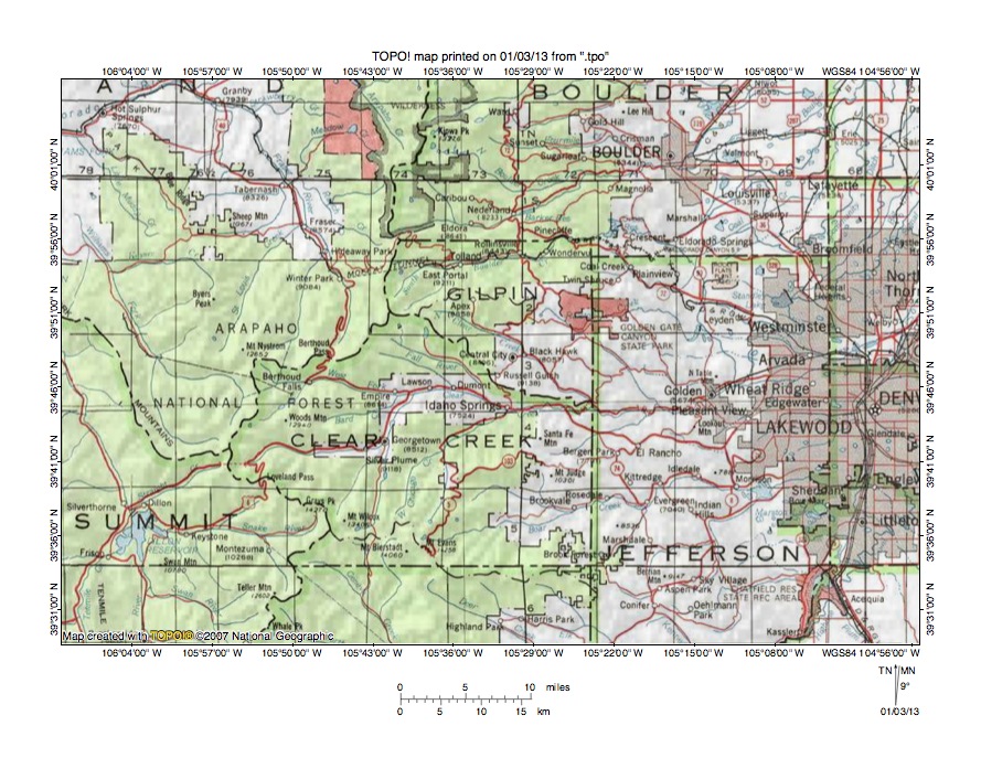
Figure 2: Detailed location map Colorado River-Clear Creek drainage divide area. United States Geological Survey map digitally presented using National Geographic Society TOPO software.
Figure 2 provides a detailed location map for the Colorado River-Clear Creek drainage divide area along the east-west continental divide. Green colored areas are National Forest lands, which in Colorado are usually located in mountain areas. County lines are shown and some county names are shown. The east-west continental divide serves as the western boundary for Boulder, Gilpin, and Clear Creek Counties and the eastern boundary for Summit County. West of the continental divide drainage flows to the Colorado River and east of the continental divide drainage flows to the South Platte River. The Colorado River flows in a west-southwest direction across the northwest corner of figure 2. The Fraser River originates near Berthoud Pass (on continental divide on northwest side border of Clear Creek County) and flows in a north and northwest direction to the towns of Winter Park, Fraser, and Tabernash before joining the Colorado River near Granby. Williams Fork originates south and west of Berthoud Pass and flows in a north-northwest direction towards the west edge of figure 2. While figure 2 shows Williams Fork as ending Williams Fork does continue in a north-northwest direction to join the Colorado River. The Blue River flows in a north direction from the south edge of figure 2 to Dillon Reservoir (near southwest corner of figure 2) and then in a north-northwest direction to the west center edge of figure 2. West of figure 2 the Blue River flows to the southwest oriented Colorado River. The Fraser River, Williams Fork, and the Blue River all join the southwest oriented Colorado River as barbed tributaries. The South Platte River flows in a north-northeast direction from the south edge of figure 2 through the Chatfield Reservoir State Recreation Area to the east center edge of figure 2. East of figure 2 the South Platte River flows in a north-northeast, southeast, and northeast direction to western Nebraska. Clear Creek originates north of Loveland Pass (on the Summit-Clear Creek County line) and flows in an east, north, east, and southeast direction to Idaho Springs and then in an east direction to Golden before turning in an east-northeast direction to join the South Platte River near the east center edge of figure 2. The West Fork Clear Creek flows from west of Berthoud Falls (near Berthoud Pass) in an east direction to join Clear Creek east of Empire. South Clear Creek originates near Mount Wilcox and flows in a north direction to join Clear Creek near Georgetown (south of Empire). South and south-southeast oriented streams south of the South Clear Creek headwaters and south of Mount Wilcox are tributaries to the southeast oriented North Fork South Platte River, which with some jogs to the east and northeast eventually joins the north oriented South Platte River.
Fraser River-West Fork Clear Creek drainage divide area

Figure 3: Fraser River-West Fork Clear Creek drainage divide area. United States Geological Survey map digitally presented using National Geographic Society TOPO software.
Figure 3 provides a topographic map of Fraser River-West Fork Clear Creek drainage divide area. The map contour interval for figure 3 is 50 meters. The east-west continental divide is shown with a dashed line extending from Mount Eva (near the north edge of figure 3-west of center) to Mount Flora, Colorado Mines Peak, Berthoud Pass, and Stanley Mountain near the west edge of figure (north half). Clear Creek flows in an east direction from near the southwest corner of figure 3 to Georgetown where it is joined by north oriented South Clear Creek. Clear Creek then flows in a north and northeast direction to be joined by east oriented West Fork Clear Creek before flowing in an east and east-southeast direction to the east edge of figure 3 (slightly south of center). East of figure 3 Clear Creek flows in an east direction to join the north oriented South Platte River. West Fork Clear Creek flows in an east direction from the west edge of figure 3 (slightly north of center) to the town of Empire and then to join northeast and east oriented Clear Creek. Bard Creek is an east-northeast and north-northeast oriented tributary joining West Fork Clear Creek near Empire. Empire Pass is south of Empire and is a 200-meter deep or deeper north-to-south oriented through valley linking the north oriented Bard Creek valley with the north oriented Clear Creek valley. The north oriented drainage route originating on the north side of Berthoud Pass and flowing to the north edge of figure 3 (west half) is the headwaters of the Fraser River. North of figure 3 the Fraser River flows in a north and northwest direction to join the southwest oriented Colorado River. The north oriented Fraser River alignment is also located on approximately the same alignment as the south oriented Colorado River headwaters valley north of where the Fraser River turns to flow in a northwest direction. Prior to headward erosion of the deep southwest oriented Colorado River valley (north of figure 3) floodwaters flowed in a south direction on the present day Fraser River alignment to and across Berthoud Pass to reach the east oriented West Fork Clear Creek valley. At that time Berthoud Pass did not present a major barrier to south oriented flow as it does today. At least for a time floodwaters continued to flow in a south direction on the present day north oriented South Clear Creek and Clear Creek alignment with the south oriented floodwaters flowing in a south direction across Empire Pass. Headward erosion of the deep southwest oriented Colorado River valley beheaded and reversed the south oriented flood flow on the present day north oriented Fraser River alignment to create the north oriented Fraser River drainage route and ended south oriented flood flow to the Clear Creek drainage basin.
Detailed map of Fraser River-West Fork Clear Creek drainage divide area

Figure 4: Detailed map of Fraser River-West Fork Clear Creek drainage divide area. United States Geological Survey map digitally presented using National Geographic Society TOPO software.
Figure 4 provides a detailed topographic map of the Fraser River-West Fork Clear Creek drainage divide area seen in less detail in figure 3. The map contour interval for figure 4 is 40 feet. The east west continental divide serves as the Grand-Clear Creek County line and extends from the east center edge of figure 4 to Colorado Mines Peak, and Berthoud Pass, and then to the west edge of figure 4 (south half). The Fraser River originates on the north side of Berthoud Pass and flows in a north-northeast direction to the north edge of figure 4 (east half). North of figure 4 the Fraser River flows in a north and northwest direction to join the southwest oriented Colorado River with water eventually reaching the Pacific Ocean. Hoop Creek originates on the south side of Berthoud Pass and flows in a south-southwest direction to join east oriented West Fork Clear Creek south of figure 4. East of figure 4 West Fork Clear Creek joins east oriented Clear Creek, which then flows to the north oriented South Platte River with water eventually reaching the Gulf of Mexico. Berthoud Pass has an elevation of 11,315 feet, which is approximately 1700 feet higher than floor of the West Fork Clear Creek valley to the south of figure 4. North of figure 4 the Fraser River elevation decreases approximately 1000 feet between Berthoud Pass and the north edge of figure 4. Colorado Mines Peak reaches and elevation of 12,493 feet and the unnamed peak where the continental divide crosses the west edge of figure 4 has an elevation of 12,505 feet. These elevations suggest Berthoud Pass is almost 1200 feet deep. Based on present day topography it is difficult to imagine how Berthoud Pass could be a water-eroded valley and there is evidence of cirques on the east sides of the mountain ridges suggesting valley glaciers flowed from those cirques into the valleys on either side of Berthoud Pass. The valley glaciers probably deepened the valleys on either side of Berthoud Pass, but the glaciers probably formed in and altered pre-existing valleys. If so, Berthoud Pass is a water-eroded valley and was eroded by large volumes of water flowing one way or the other across the present day continental divide. Based on valley orientations north and south of figure 4 the most likely direction of flow was from the north to the south. The south oriented flow had to occur prior to headward erosion of the southwest oriented Colorado River valley, which captured the south oriented flood flow and beheaded and reversed the flood flow route on the Fraser River alignment. Uplift of the mountain ridge seen in figure 4 probably contributed significantly to the Fraser River reversal of flow and probably continued after all flood flow across Berthoud Pass had ended. Glaciation occurred after flood flow had ended and after the region had been uplifted to form the high mountain ridges seen today.
West Fork Clear Creek-Clear Creek drainage divide area

Figure 5: West Fork Clear Creek-Clear Creek drainage divide area. United States Geological Survey map digitally presented using National Geographic Society TOPO software.
Figure 5 illustrates the West Fork Clear Creek-Clear Creek drainage divide area west of figure 3 and there is an overlap area with figure 3. The map contour interval for figure 5 is 50 meters. The east-west continental divide is shown with a labeled dashed line extending from near the southwest corner of figure 5 to near the northeast corner of figure 5. Clear Creek flows in a northeast, east-southeast, and east direction from the south edge of figure 5 (west of center) to the east edge of figure 5 (near southeast corner). East of figure 5 Clear Creek flows in a north and east direction to join the north oriented South Platte River with water eventually reaching the Gulf of Mexico. Herman Gulch is an east and southeast oriented tributary joining Clear Creek north of the south center edge of figure 5. Berthoud Pass is located near the northeast corner of figure 5. The north oriented stream originating on the north side of Berthoud Pass is the Fraser River, which north of figure 5 flows in a north and northwest direction to join the southwest oriented Colorado River as a barbed tributary. The east oriented stream south of Berthoud Pass is West Fork Clear Creek, which flows to the east edge of figure 5 (north of center) and east of figure 5 joins east oriented Clear Creek. Woods Creek is a northeast oriented tributary originating north of the Herman Gulch headwaters and joining West Fork Clear Creek south of Stanley Mountain. Vasquez Pass is located west of Stanley Mountain. The north oriented stream originating north of Vasquez Pass is Vasquez Creek, which north of figure 5 flows to the north and northwest oriented Fraser River. Williams Fork is a west oriented stream flowing to the west edge of figure 5 (north half). West of figure 5 Williams Fork turns to flow in a north-northwest direction to join the southwest oriented Colorado River as a barbed tributary. The South Fork Williams Fork can be seen north of the Williams Fork Mountains near the southwest corner of figure 5. Today the high mountain ridges, especially the continental divide ridge, form massive barriers between deep valleys on either side. However valley orientations and the presence of passes, notches, and or gaps crossing those high mountain ridges provide evidence of what were probably diverging and converging south oriented flood flow channels that existed prior to headward erosion of the deep valleys seen today. At the time floodwaters flowed across the region seen in figure 5 those high mountain ridges did not exist, nor did the deep valleys surrounding those ridges exist. The landscape seen in figure 5 was formed as floodwaters flowed across the region while crustal warping raised the region and headward erosion of the deep southwest oriented Colorado River valley to the north of figure 5 beheaded and reversed the south oriented flood flow channels. North oriented drainage routes seen in figure 5 were probably created by reversals of flood flow on north ends of beheaded flood flow channels. Uplift probably continued after floodwaters creased to flow across the region and once high mountains had been formed alpine glaciers formed at some of the higher valleys. The glaciers formed in flood-eroded valleys and may have deepened and otherwise altered some of those valleys, but the glaciers did not erode new valleys or erode the major mountain passes.
Detailed map of Woods Creek-Herman Gulch drainage divide area

Figure 6: Detailed map of Woods Creek-Herman Gulch drainage divide area. United States Geological Survey map digitally presented using National Geographic Society TOPO software.
Figure 6 provides a detailed topographic map of the Woods Creek-Herman Gulch drainage divide area seen in less detail in figure 5. The map contour interval for figure 6 is 40 feet. The east-west continental divide is shown with a labeled dashed line in the northwest quadrant of figure 6. Herman Gulch originates near the west edge of figure 6 (south half) and drains in an east and southeast direction to the south edge of figure 6 (east half). South of figure 6 Herman Gulch drains to east-southeast and east oriented Clear Creek, which east of figure 5 turns to flow in a north direction at the point where it is joined by north oriented South Clear Creek. After flowing in a north and northeast direction Clear Creek is joined by east oriented West Fork Clear Fork and then flows in an east direction. Woods Creek flows in a northeast direction from near the center of figure 6 to the north edge of figure 6 (east half). North and east of figure 6 Woods Creek flows to east oriented West Fork Clear Creek. As seen in figure 3 both Clear Creek and West Fork Clear Creek flow to what is today a north oriented valley, but which as seen in figure 9 is linked by a through valley or pass the south oriented valleys draining to the southeast oriented North Fork South Platte River. A north-to-south oriented gap or through valley near the center of figure 6 links the northeast oriented Woods Creek valley with the east and southeast oriented Herman Gulch valley. The gap elevation is between 11,920 and 11,960 feet. Pettingell Peak to the west rises to 13,553 feet and Woods Mountain to the northeast rises to 12,940 feet suggesting the gap is approximately 1000 feet deep. What are probably two small cirques can be seen at the head of Herman Gulch and another cirque can be seen on the northwest side of the continental divide. These cirques provide evidence alpine glaciers did form in the region, although evidence for deep glacial erosion is not present. The gap was probably eroded by south oriented flood flow moving to the east and southeast oriented Herman Gulch valley prior to headward erosion of the deep northeast oriented Woods Creek valley, which captured the south oriented flood flow. At that time the Clear Creek and West Fork Clear Creek valleys were eroding headward from a south oriented flood flow channel on the present day north oriented South Clear Creek alignment. If correctly interpreted floodwaters were flowing in south oriented flood flow channels, which today have floors at an elevation of almost 12,000 feet. Uplift was probably occurring as floodwaters flowed across the region and the region has experienced significant uplift since floodwaters ceased to flow across the area, although headward erosion of the deep southwest oriented Colorado River valley north of figure 6 was the specific event responsible for ending the south oriented flood flow into the region.
Clear Creek-Blue River drainage divide area
Figure 7: Clear Creek-Blue River drainage divide area. United States Geological Survey map digitally presented using National Geographic Society TOPO software.
Figure 7 illustrates the Clear Creek-Blue River drainage divide area south and west of figure 5 and includes an overlap area with figure 5. The map contour interval for figure 7 is 50 meters. The east-west continental divide is shown with a labeled dashed line extending from the north edge of figure 7 (east half) to the east edge of figure 7 (south of center). Loveland Pass crosses the continental divide near the east center edge of figure 7. Dillon Reservoir is the lake straddling the south edge of figure 7. The Blue River flows in a north direction to Dillon Reservoir (south of figure 7) and then flows in a north-northwest direction from Dillon Reservoir to the west edge of figure 7 (near northwest corner). West and north of figure 7 the Blue River flows to the southwest oriented Colorado River as a barbed tributary. The Snake River flows in a north and then in a west direction from the south edge of figure 7 (near southeast corner) to Dillon Reservoir. The North Fork Snake River originates south of Loveland Pass and flows in a southwest direction to join the west oriented Snake River. Clear Creek originates north of Loveland Pass and flows in a northeast and east direction to the east edge of figure 7 (north half). East of figure 7 Clear Creek flows in an east, north, and east direction to join the South Platte River with water eventually reaching the Gulf of Mexico. East and southeast oriented Herman Gulch can be seen in the northeast corner of figure 7. Loveland Pass has an elevation of 3659 meters. Mountains east of the pass rise to more than 4000 meters and Hager Mountain to the northwest of Loveland Pass rises to 4023 meters. These elevations suggest Loveland Pass could be as much as 350 meters deep. Loveland Pass originated as a water-eroded valley and was eroded by south oriented flood flow moving to the southwest oriented North Fork Snake River valley. Floodwaters flowed to a south oriented flood flow channel on the present day north oriented Blue River alignment (south of figure 7 the north oriented Blue River valley is linked by Hoosier Pass with the south oriented headwaters of the Middle Fork South Platte River). Headward erosion of the deep southwest oriented Colorado River valley beheaded and reversed the south oriented flood flow channel on the Blue River alignment to create the north and north-northwest oriented Blue River drainage route. Headward erosion of the east oriented Clear Creek valley (from a south oriented flood flow channel on the present day north oriented South Clear Creek alignment) beheaded the south oriented flood flow route across Loveland Pass. These flood flow captures and reversals took place as crustal warping was raising the mountain ridges seen in figure 7 (and the entire state of Colorado). Crustal warping continued after flood flow ended and once the region had been uplifted to produce high mountains glaciers probably filled some of the valleys. If so the glaciers filled flood-eroded valleys and did not erode new valleys.
Detailed map of Clear Creek-North Fork Snake River drainage divide area
Figure 8: Detailed map of Clear Creek-North Fork Snake River drainage divide area. United States Geological Survey map digitally presented using National Geographic Society TOPO software.
Figure 8 provides a detailed topographic map of the Clear Creek-North Fork Snake River drainage divide area seen in less detail in figure 7. The map contour interval for figure 8 is 40 feet. The east-west continental divide is shown with a labeled dashed line extending from the west edge of figure 8 (north half) to the east edge of figure 8 (near southeast corner). Loveland Pass is located near the center of figure 8. The North Fork Snake River originates on the south side of Loveland Pass and flows in a south and southwest direction to the south center edge of figure 8. South of figure 8 the North Fork flows in a southwest direction to join the west oriented Snake River, which joins the north-northwest oriented Blue River at Dillon Reservoir with water flowing to the Colorado River and Pacific Ocean. Clear Creek originates in the northwest quadrant of figure 8 and flows in an east-northeast direction to the north edge of figure 8 (west half). North of figure 8 Clear Creek turns to flow in an east, north, and east direction to reach the South Platte River with water eventually reaching the Gulf of Mexico. Loveland Pass has an elevation of 11,990 feet. Mountains east of Loveland Pass rise to more than 13,000 feet while mountains west of Loveland Pass (and seen in figure 8) rise to more than 12,700 feet suggesting Loveland Pass is at least 700 feet deep. If elevations not seen in figure 8 are used Loveland Pass could be much deeper. Loveland Pass is a significant notch cut into the continental divide. Other north-to-south oriented notches or passes crossing the continental divide can be seen west of Loveland Pass. Some of these other notches or passes are also several hundred feet deep. These notches or passes were originally eroded by diverging and converging south oriented flood flow channels flowing on an erosion surface now preserved, if it is preserved at all, by crests of the high mountain ridges seen in figure 8. At the time floodwaters flowed across the region the mountain ridges did not stand high above surrounding regions as they do today. Since that time deep valleys have eroded headward into the region to capture the south oriented flood flow and the mountains have been uplifted. Also since that time valley glaciers have probably deepened and otherwise altered some of the valleys.
South Clear Creek-Duck Creek drainage divide area
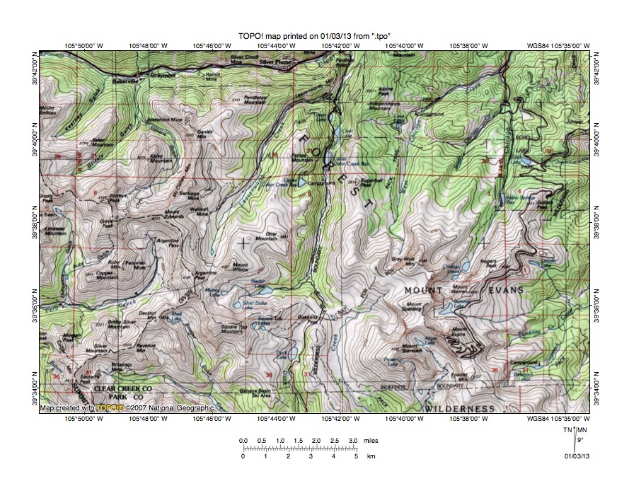
Figure 9: South Clear Creek-Duck Creek drainage divide area. United States Geological Survey map digitally presented using National Geographic Society TOPO software.
Figure 9 illustrates the South Clear Creek-Duck Creek drainage divide area south and east of figure 5 and there is an overlap area with figure 5. Figure 9 is also east of figure 7 and includes a small overlap area with figure 7. The map contour interval for figure 9 is 50 meters. The east-west continental divide is shown with a labeled dashed line extending from the west edge of figure 9 (north half) to the south edge of figure 9 (near southwest corner). Clear Creek flows in an east direction to near the north center edge of figure 9 where it is joined by north oriented South Clear Creek and turns to flow in a north direction (see figure 3). North of figure 9 Clear Creek flows in a north and east direction to join the north oriented South Platte River. South Clear Creek originates on the north side of Guanella Pass and flows in a north direction to join east and north oriented Clear Creek near the north center edge of figure 9. Duck Lake is located on the south side of Guanella Pass and Duck Creek flows in a south direction from Duck Lake to the south center edge of figure 9. South of figure 9 Duck Creek flows to southeast oriented Geneva Creek, which then flows to the southeast oriented North Fork South Platte River. The North Fork South Platte River then flows in a southeast, east, northeast, and southeast direction to join the north-northeast oriented South Platte River. The south oriented stream just east of Duck Creek is Scott Gomer Creek, which also flows to southeast oriented Geneva Creek. Guanella Pass has an elevation of between 3450 and 3500 meters. Mount Bierstadt to the east rises to 4281 meters and Square Top Mountain to the west rises to more than 4200 meters suggesting Guanella Pass could be as much as 700 meters deep. Guanella Pass is an easier pass to interpret than Loveland Pass and was eroded by diverging (and converging) south oriented flood flow channels moving floodwaters from the present north oriented South Clear Creek alignment to the southeast oriented North Fork South Platte River valley. At that time the North Fork South Platte River valley was eroding headward from south oriented flood flow channels on the present day north oriented South Platte River alignment. Headward erosion of the east oriented Clear Creek valley seen in figure 3 beheaded and reversed the south oriented flood flow on the South Clear Creek alignment to create the north oriented South Clear Creek and Clear Creek drainage route north of Guanella Pass. The east oriented Clear Creek valley probably eroded headward from south oriented flood flow channels on the present day north oriented South Platte River alignment. As flood flow captures and reversals were occurring in the mountains west of the Colorado Piedmont headward erosion of the southeast and northeast oriented South Platte River valley from western Nebraska beheaded and reversed the south oriented flood flow channels on the Colorado Piedmont to create the present day north oriented South Platte River and tributary drainage routes.
Detailed map of South Clear Creek-Duck Creek drainage divide area

Figure 10: Detailed map of South Clear Creek-Duck Creek drainage divide area. United States Geological Survey map digitally presented using National Geographic Society TOPO software.
Figure 10 provides a detailed topographic map of the South Clear Creek-Duck Creek drainage divide area seen in less detail in figure 9. The map contour interval for figure 10 is 40 feet. South Clear Creek flows in an east direction from Naylor Lake before turning to flow in a north direction to the north center edge of figure 10. North of figure 10 South Clear Creek flows in a north direction to join north and east oriented Clear Creek, which flows to the north oriented South Platte River. Guanella Pass is located near the center of figure 10. Duck Creek flows in a south direction from Guanella Pass to Duck Lake and then to the south edge of figure 10 (west of center). South of figure 10 Duck Creek flows in a south direction to join southeast oriented Geneva Creek, which then flows to the southeast oriented North Fork South Platte River. The North Fork South Platte River flows primarily in a southeast direction, but also makes some east and northeast jogs, to reach the north-northeast oriented South Platte River. Scott Gomer Creek flows in a southwest direction from the east edge of figure 10 (north half) to the Guanella Pass area and then flows in a south direction to the south center edge of figure 10. South of figure 10 Scott Gomer Creek flows to southeast oriented Geneva Creek, which flows to the North Fork South Platte River. Guanella Pass has an elevation of 11,669 feet. Mount Bierstadt near the southeast corner of figure 10 has an elevation of 14,060 feet. Square Top Mountain, which is just west of figure 10, has an elevation of 13,794 feet. These elevations suggest Guanella Pass may be more than 2000 feet deep. Guanella Pass is a water-eroded valley and today water draining from both sides of Guanella Pass ends up in the north oriented South Platte River. Guanella Pass was eroded by two diverging south oriented flood flow channels with one flood flow channel following the present day Duck Creek alignment and the other flood flow channel following the Scott Gomer Creek alignment. Floodwaters moved in a south direction on the present day north oriented South Clear Creek and Clear Creek alignments to reach the Guanella Pass location. South of figure 10 floodwaters on the two diverging flood flow channels converged again on the southeast oriented North Fork South Platte River alignment and probably flowed to a south oriented flood flow channel on the present day north oriented South Platte River alignment. Headward erosion of the east oriented Clear Creek valley (north of figure 10) beheaded and reversed the south oriented flood flow channel to create the north oriented South Clear Creek drainage route. Crustal warping that raised the mountain ridge Guanella Pass crosses probably contributed significantly to the flood flow reversal. After floodwaters ceased to flow across the region and after the mountains had been uplifted the flood-eroded valleys were glaciated with the valley glaciers deepening and otherwise altering at least some of the valleys.
Additional information and sources of maps studied
This essay has provided only a sample of the detailed topographic map evidence supporting the flood erosion interpretation. Many additional illustrations could be provided. Readers are encouraged to look at mosaics of detailed topographic maps to see the abundance of available data. Maps used in this study were created and published by the United States Geologic Survey and can be obtained directly from the United States Geological Survey and/or from dealers offering United States Geological Survey maps. Hard copy maps can also be observed at United States Geological Survey map depositories, which are located throughout the United States and elsewhere. Illustrations used here were created using National Geographic Society TOPO software and digital map data. TOPO software and map data can be obtained from the National Geographic Society and/or dealers offering National Geographic Society digital map data.

Leave a comment