
Abstract:
This essay uses topographic map evidence to interpret landform origins in the Clear Creek-Bear Creek drainage divide area in the Colorado Front Range. Clear Creek is a north and east oriented stream originating in the Colorado Front Range and joining the north, southeast, and northeast oriented South Platte River on the Colorado Piedmont slightly north of Denver. Bear Creek originates east of the north oriented Clear Creek headwaters and flows in an east-northeast and east direction to join the South Platte River slightly south of Denver. Through valleys or mountain passes link the Clear Creek and Bear Creek valleys and with the valley of an east and northeast oriented Clear Creek tributary. The through valleys are found in high mountain areas where the streams originate and also where the streams emerge from the Front Range to flow onto Colorado Piedmont before reaching the north oriented South Platte River. Valley orientations and the through valleys are interpreted in the context of massive melt water floods from the western margin of a thick North American ice sheet. Floodwaters flowed from western Canada to and across Colorado at a time when the Colorado Front Range was just beginning to emerge. East oriented valleys eroded headward in sequence from south to north from south oriented flood flow channels on the Colorado Piedmont to capture south oriented flood flow moving across the emerging Front Range. Headward erosion of the Bear Creek valley captured south and southeast oriented flood flow prior to headward erosion of the east oriented Clear Creek valley. Headward erosion of the Clear Creek valley beheaded and reversed flood flow channels to the newly eroded Bear Creek valley and then beheaded and reversed south oriented flood flow channels west of the Bear Creek valley head to create north oriented Clear Creek headwaters drainage routes. Headward erosion of the deep southwest oriented Colorado River valley north of the Clear Creek headwaters beheaded and reversed south oriented flood flow channels to the Clear Creek headwaters area. At about the same time headward erosion of the deep southeast and northeast oriented South Platte River valley from western Nebraska beheaded south oriented flood flow channels on the Colorado Piedmont. Floodwaters on north ends of beheaded flood flow channels reversed flow direction to create north oriented South Platte River and tributary drainage routes. Ice sheet related crustal warping raised the Front Range and Colorado as floodwaters flowed across the region and probably contributed significantly to flood flow reversals. After flood flow across the region had ended and after the Front Range had become a high mountain range mountains in the Clear Creek and Bear Creek headwaters area were glaciated and valley glaciers deepened and otherwise altered some of the flood eroded valleys.
Preface
The following interpretation of detailed topographic map evidence is one of a series of essays describing similar evidence for all major drainage divides contained within the Missouri River drainage basin and for all major drainage divides with adjacent drainage basins. The research project is interpreting evidence in the context of a previously unexplored deep glacial erosion paradigm, which is fundamentally different from most commonly accepted North American glacial history interpretations. Project essays are listed on the sidebar category list under their appropriate Missouri River tributary drainage basin, Missouri River segment drainage basin (by state), and/or state in which the Missouri River drainage basin is located.
Introduction
The purpose of this essay is to use topographic map interpretation methods to explore the Clear Creek-Bear Creek drainage divide area landform origins in the Colorado Front Range. Map interpretation methods can be used to unravel many geomorphic events leading up to formation of present-day drainage routes and development of other landform features. While each detailed topographic map feature provides detailed evidence to be explained, the solution must be consistent with explanations for adjacent area map evidence as well as solutions to big picture map evidence puzzles. I invite readers to improve upon my solutions and/or to propose alternate solutions that better explain evidence and are also consistent with adjacent map area and big-picture evidence. Readers may do so either by making comments here or by writing and publishing their own essays and then by leaving a link to those essays in a comment here.
This essay is also exploring a new geomorphology paradigm in which erosional landforms are interpreted as evidence left by immense glacial melt water floods. Implied in that interpretation is the immense floods were derived from a thick North American ice sheet that created a deep “hole” in the North American continent and also melted fast. The previously unexplored paradigm being tested in this and other Missouri River drainage basin landform origins research project essays is a thick North American ice sheet, comparable in thickness to the Antarctic ice sheet, occupied the North American region usually recognized to have been glaciated, and through its weight and erosive actions created a deep North American “hole”. The southwestern rim of that deep “hole” is today preserved in the high Rocky Mountains. The ice sheet through its weight and deep erosion (and perhaps deposition along major south-oriented melt water flow routes) caused significant crustal warping and tectonic change, through its action of melting fast produced immense floods that flowed across the continent, and through its action of melting fast systematically opened up space in the ice sheet created “hole” so headward erosion of newly developed north-oriented drainage systems captured immense south-oriented melt water floods and diverted immense melt water floods north into space the ice sheet had once occupied.
If this previously unexplored paradigm is correct the geographic region explored by this essay should contain evidence of immense floods that were captured by headward erosion of new valley systems so as to cause the floods to flow in a different direction. Ability of this previously unexplored paradigm to explain Clear Creek-Bear Creek drainage divide area landform evidence in the Colorado Front Range will be regarded as evidence supporting the “thick ice sheet that melted fast” paradigm.
Clear Creek-Bear Creek drainage divide area location map
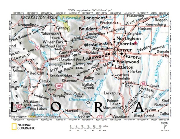
Figure 1: Clear Creek-Bear Creek drainage divide area location map (select and click on maps to enlarge). National Geographic Society map digitally presented using National Geographic Society TOPO software.
Figure 1 provides a location map for the Clear Creek-Bear Creek drainage divide area in the Colorado Front Range and illustrates a region in central Colorado. The South Platte River flows in a north-northeast and north direction from the south center edge of figure 1 to the north edge of figure 1 (east half). North of figure 1 the South Platte River turns to flow in a southeast and then northeast direction to join the North Platte River in western Nebraska and to form the Nebraska Platte River with water eventually reaching the Gulf of Mexico. The Colorado Front Range is located west of the north-northeast and north oriented South Platte River, which is located on the Colorado Piedmont. South Platte River headwaters originate in the Front Range and flow in a southeast direction near the towns of Alma, Fairplay, and Hartsel before reaching the south edge of figure 1 and then turning to flow in a north-northeast direction. North oriented streams near the east edge of figure 1 are tributaries to the southeast oriented South Platte River segment north of figure 1. The green colored area straddling the north edge of figure 1 is the south end of Rocky Mountain National Park. The Colorado River flows in a south direction to Lake Granby at the southwest corner of Rocky Mountain National Park, where it turns to flow in a west-southwest and southwest direction to the west edge of figure 1 (north half) with water eventually reaching the Pacific Ocean. Clear Creek and Bear Creek are shown in figure 1, but are not labeled. Clear Creek is difficult to see and flows in an east direction through Idaho Springs and Golden to join the South Platte River just north of Denver. Bear Creek is easier to see and originates near Mount Evans before flowing in an east-northeast direction to Evergreen and then in an east direction to join the South Platte River near Englewood. The Clear Creek-Bear Creek drainage divide area investigated in this essay is located south of Clear Creek and north of Bear Creek and extends from the Bear Creek headwaters to the South Platte River.
Colorado drainage routes developed during immense melt water floods from the western margin of a thick North American ice sheet. Floodwaters flowed from western Canada to and across Colorado at a time when Colorado mountain ranges were beginning to emerge. The mountain ranges emerged as floodwaters flowed across them, as ice sheet related crustal warping raised the mountain masses and the entire state of Colorado, and as deep valleys eroded headward into Colorado from the Gulf of Mexico and from the Pacific Ocean to capture the massive south oriented melt water flood flow. Present day north oriented South Platte River and tributary drainage routes on the Colorado Piedmont originated as south oriented flood flow channels east of the emerging Front Range. East oriented valleys, such as the Bear Creek and Clear Creek valleys eroded headward from those south oriented flood flow channels in sequence from south to north to capture south and southeast oriented flood flow in the Front Range region. The south oriented flood flow channels on the Colorado Piedmont were captured by headward erosion of the southeast oriented Arkansas River south of figure 1 (south oriented Arkansas River headwaters can be seen near the southwest corner of figure 1). Subsequently headward erosion of the deep southeast and northeast oriented South Platte River valley from western Nebraska (north of figure 1) beheaded the south oriented flood flow channels on the Colorado Piedmont. Floodwaters on north ends of the beheaded flood flow channels reversed flow direction to flow in a north direction to the deeper southeast and northeast oriented South Platte River valley and to create the north oriented South Platte River drainage route and tributary drainage routes seen today. The reversed flood flow captured southeast oriented flood flow still moving across the emerging Front Range. Headward erosion of the deep southwest oriented Colorado River valley then beheaded the south and southeast oriented flood flow channels to the south and southeast oriented Arkansas River and South Platte River headwaters. Floodwaters on north and northwest ends of beheaded flood flow channels reversed flow direction to create north-northwest and northwest oriented Colorado River tributaries. These flood flow captures and reversals took place as ice sheet related crustal warping was raising the entire region and large mountain masses within the region.
Detailed location map for Clear Creek-Bear Creek drainage divide area

Figure 2: Detailed location map of Clear Creek-Bear Creek drainage divide area. United States Geological Survey map digitally presented using National Geographic Society TOPO software.
Figure 2 provides a detailed location map for the Clear Creek-Bear Creek drainage divide area in the Colorado Front Range. Green colored areas are National Forest lands, which in Colorado are usually located in mountain regions. The Denver metropolitan area is located in the east half of figure 2 and the Colorado Front Range is located west of the metropolitan area. The South Platte River flows in a north-northeast direction from the south edge of figure 2 (east half) to the northeast corner of figure 2. South of figure 2 the South Platte River flows in a southeast and then north-northeast direction through Platte Canyon to reach the town of South Platte near the south edge of figure 2. North of figure 2 the South Platte River flows in a north-northeast and north direction before turning in a southeast and northeast direction to flow to western Nebraska. Berthoud Pass is located near the northwest corner of figure 2. The West Fork Clear Creek flows in an east direction from the west edge of figure 2 (just south of Berthoud Pass) to the town of Empire and then to join north and east oriented Clear Creek. South Clear Creek originates near Mount Wilcox (near west edge of figure 2-south of center) and flows in a north direction to Georgetown where it joins east oriented Clear Creek, which turns to flow in a north direction to be joined by its east oriented West Fork before turning to flow in an east direction to flow to Idaho Springs and then to Golden before flowing to join the South Platte River near the northeast corner of figure 2. East of the north oriented Clear Creek headwaters is north-northeast oriented West Chicago Creek, which joins north and northeast oriented Chicago Creek, which then joins east oriented Clear Creek near Idaho Springs. North oriented Chicago Creek headwaters originate just north of Mount Evans. Beaver Brook is the unlabeled east-northeast oriented Clear Creek tributary joining Clear Creek west of Golden. Bear Creek originates just east of Mount Evans and flows in an east-northeast direction to Brookvale, Rosedale, and Evergreen before flowing into the Denver metropolitan area where it joins the South Platte River near Englewood. Corral Creek is the unlabeled south and southeast oriented tributary joining Bear Creek near Brookvale and Vance Creek is the unlabeled east-northeast and east-southeast oriented tributary joining Corral Creek west of Brookvale.
Clear Creek-Vance Creek drainage divide area

Figure 3: Clear Creek-Vance Creek drainage divide area. United States Geological Survey map digitally presented using National Geographic Society TOPO software.
Figure 3 provides a topographic map of Clear Creek-Vance Creek drainage divide area. The map contour interval for figure 3 is 50 meters. South Clear Creek flows in a north direction from the south edge of figure 3 (near southwest corner) to Georgetown where it joins east oriented Clear Creek, which turns to flow in a north direction before gradually turning to flow in an east and east-southeast direction to Idaho Springs before flowing in an east direction to the east edge of figure 3. East of figure 3 Clear Creek flows in an east direction to join the north oriented South Platte River. West Fork Clear Creek flows in an east direction from the west edge of figure 3 (near northwest corner) through Empire to join east oriented Clear Creek. Empire Pass is located south of Empire and links the east-oriented West Fork valley with the north-oriented Clear Creek headwaters valley. Empire Pass is defined by five contour lines on the northeast side suggesting the pass is at least 200 meters deep. Empire Pass was eroded by south oriented flood flow moving to a south oriented flood flow channel on the present day north oriented South Clear Creek headwaters alignment. The south oriented flood flow channel was beheaded and reversed by headward erosion of the east oriented Clear Creek and West Fork Clear Creek valley. Goliath Peak is located just north of the south center edge of figure 3 and Idaho Springs Reservoir is west of Goliath Peak. Chicago Creek flows in a north and northeast direction from Idaho Springs Reservoir to join east oriented Clear Creek at Idaho Springs. Vance Creek originates east of Goliath Peak and flows in a northeast and east-southeast direction to join south and southeast oriented Corral Creek near the southeast corner of figure 3. South and east of figure 3 Corral Creek joins east oriented Bear Creek, which then flows to the north-oriented South Platte River. Corral Creek originates on the south side of Squaw Pass. North of Squaw Pass are headwaters of northwest oriented Little Bear Creek, which flows to Soda Creek, which then flows to Clear Creek, although the north side of Squaw Pass is drained by an east-northeast tributary to east-northeast oriented Beaver Brook (east of figure 3), which flows to Clear Creek. Squaw Pass was eroded by southeast and south oriented flood flow prior to headward erosion of the east-northeast oriented Beaver Brook and tributary valley, which captured the south oriented flood flow. Headward erosion of the east oriented Clear Creek valley then beheaded and reversed the southeast and south oriented flood flow channel to create the northwest oriented Little Bear Creek drainage route. North of Goliath Peak a west-to-east oriented through valley links the north oriented Chicago Creek valley with an east oriented Vance Creek tributary valley. The through valley floor elevation is between 3250 and 3300 meters. Elevations on Goliath Peak reach 3721 meters and the Clear Creek-Vance Creek drainage divide to the east rises to more than 3500 meters suggesting the through is at least 200 meters deep. The through valley was eroded by south and east oriented flood flow moving on the present day north oriented Chicago Creek alignment to the east oriented Vance Creek and Bear Creek valleys prior to headward erosion of the deep east oriented Clear Creek valley and its northeast oriented Chicago Creek tributary valley. Headward erosion of the northeast oriented Chicago Creek valley segment beheaded and reversed the south oriented flood flow channel to create the north and northeast oriented Chicago Creek drainage route seen today.
Detailed map of Chicago Creek-Vance Creek drainage divide area
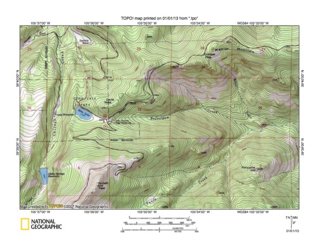
Figure 4: Detailed map of Chicago Creek-Vance Creek drainage divide area. United States Geological Survey map digitally presented using National Geographic Society TOPO software.
Figure 4 provides a detailed topographic map of the Chicago Creek-Vance Creek drainage divide area seen in less detail in figure 5. The map contour interval for figure 4 is 40 feet. South Chicago Creek can be seen flowing in a northeast direction across the northwest corner of figure 4 and joins Chicago Creek north of figure 4. Chicago Creek flows in a north direction from near the southwest corner of figure 4 to the north edge of figure 4 (near northwest corner). North of figure 4 Chicago Creek turns in a northeast direction to join east oriented Clear Creek. Vance Creek flows in a northeast and east direction from the south center edge of figure 4 to the east center edge of figure 4. East of figure 4 Vance Creek joins Corral Creek, which then flows to east oriented Bear Creek. Beaverdam Creek is an east oriented tributary flowing from section 32 to join Vance Creek in section 34. Echo Lake in section 31 is located in a west-to-east oriented through valley linking the north oriented Chicago Creek valley with the east oriented Beaverdam and Vance Creek valleys. The through valley floor elevation is 10,650 feet. Goliath Peak to the south rises to 12,216 feet and Warrior Mountain to the northeast rises to 11,273 feet suggesting the through valley is approximately 620 feet deep. The through valley is a water-eroded valley and was eroded by south and east oriented flood flow moving from the present day north oriented Chicago Creek alignment to the east oriented Beaverdam Creek-Vance Creek alignment. The south oriented flood flow on the Chicago Creek alignment was beheaded and reversed by headward erosion of the east oriented Clear Creek valley and its northeast oriented Chicago Creek tributary valley (north of figure 4). The Chicago Creek flood flow reversal was probably greatly aided by crustal warping that was raising the Chicago Creek headwaters area. Echo Lake is in a closed depression bounded on the west by a linear ridge that probably is a lateral moraine. If so, the glaciation responsible for the lateral moraine occurred after all flood flow in the region had ended and after crustal warping had uplifted the region and mountains to create the high mountains seen today. The lateral moraine valley would have been formed by a glacier extending northward in the Chicago Creek valley from the higher Chicago Creek headwaters area to the south of figure 4 (to at least the Echo Lake location). A valley glacier in the Chicago Creek valley probably would have deepened the Chicago Creek valley, but would not have eroded new valleys such as the west-to-east oriented through valley.
Clear Creek-Corral Creek drainage divide area

Figure 5: Clear Creek-Corral Creek drainage divide area. United States Geological Survey map digitally presented using National Geographic Society TOPO software.
Figure 5 illustrates the Clear Creek-Corral Creek drainage divide area east of figure 3 and there is an overlap area with figure 3. The map contour interval for figure 5 is 50 meters. Clear Creek flows in an east-southeast direction to Idaho Springs from the northwest corner of figure 5 and then in an east direction to the east edge of figure 5 (near northeast corner). East of figure 5 Clear Creek flows to the north oriented South Platte River. Squaw Mountain is south of Idaho Springs and Squaw Pass is located east of Squaw Mountain. The northwest oriented stream north of Squaw Mountain is Little Bear Creek, which flows to north-northeast oriented Soda Creek, which joins Clear Creek at Idaho Springs. The east and east-northeast oriented stream originating east of Little Bear Creek and flowing to join Clear Creek near the northeast corner of figure 5 is Beaver Brook. Beaver Brook headwaters are located north of Squaw Pass. Bear Creek flows in a northeast and east-northeast direction from the south edge of figure 5 (west of center) and then makes a southeast jog to Evergreen Lake before turning in a northeast direction to flow to the east edge of figure 5 (south of center). East of figure 5 Bear Creek flows in an east direction to join the north oriented South Platte River. Corral Creek is a south and southeast oriented tributary flowing from near Squaw Pass to join Bear Creek near Brookvale. Vance Creek flows in a northeast and southeast direction from the west edge of figure 5 (near southwest corner) to join southeast oriented Corral Creek. East of Squaw Pass is Mount Judge. The southeast oriented Bear Creek tributary east of Mount Judge is Witter Gulch. A northwest-to-southeast oriented through valley or pass located east of Mount Judge links a northwest oriented valley draining to east-northeast oriented Beaver Brook with the southeast oriented Witter Gulch valley. Squaw Pass has an elevation of between 2950 and 3000 meters. Mount Judge to east rises to 3140 meters suggesting Squaw Pass is at least 140 meters deep. The Beaver Brook-Witter Gulch through valley or pass has a floor elevation of between 2750 and 2800 meters. Snyder Mountain to the east rises to at least 3000 meters suggesting the through valley or pass is approximately 200 meters deep. Squaw Pass and the Beaver Brook-Witter Gulch through valley (or pass) provide evidence of what were probably diverging and converging south or southeast oriented flood flow channels flowing to the actively eroding Bear Creek valley at a time when the Beaver Brook and Clear Creek valleys to the north did not exist. The southeast oriented flood flow moved on the alignment of present day northwest oriented Little Bear Creek. Headward erosion of the east-northeast oriented Beaver Brook valley captured the southeast and south oriented flood flow and beheaded flood flow channels to the southeast oriented Witter Gulch and to the south and southeast oriented Corral Creek valleys. A 300-meter deep through valley links the northwest oriented Little Bear Creek headwaters valley with the southeast oriented Beaver Brook headwaters valley. The through valley was eroded by southeast oriented flood flow captured by headward erosion of the east-northeast oriented Beaver Brook valley. Headward erosion of the east oriented Clear Creek valley and its north-northeast oriented Soda Creek tributary valley subsequently beheaded and reversed the southeast oriented flood flow channel to Beaver Brook to create the northwest oriented Little Bear Creek drainage route.
Detailed map of Beaver Brook-Corral Creek drainage divide area

Figure 6: Detailed map of Beaver Brook-Corral Creek drainage divide area. United States Geological Survey map digitally presented using National Geographic Society TOPO software.
Figure 6 provides a detailed topographic map of the Beaver Brook-Corral Creek drainage divide area seen in less detail in figure 5. The map contour interval for figure 6 is 40 feet. Beaver Brook flows in a southeast direction in section 17 and then turns to flow in an east and east-northeast direction to the northeast corner of figure 6. North and east of figure 6 Beaver Brook flows to east oriented Clear Creek. Deadman Gulch is the north-northeast and east-northeast oriented Beaver Brook tributary in section 20. The north-northeast oriented stream flowing across the northwest corner of figure 6 is the headwaters of northwest oriented Little Bear Creek, which flows to north-northeast oriented Soda Creek, which in turn flows to east oriented Clear Creek. Squaw Pass is located in the southwest corner of section 20 and has an elevation of 9798 feet and links the north-northeast and east-northeast oriented Deadman Gulch valley with the south oriented Corral Creek valley. South of figure 6 Corral Creek turns in a southeast direction to join east oriented Bear Creek. Squaw Mountain to the west rises 11,486 feet and Mount Judge to the east rises to 10,301 feet suggesting Squaw Pass is approximately 500 feet deep. A northwest-to-southeast oriented through valley or pass is located near the east edge of section 28 and links a northwest and north oriented Beaver Brook tributary valley with the southeast oriented Witter Gulch valley. South of figure 6 Witter Gulch drains to east oriented Bear Creek. The through valley or pass elevation is 9185 feet. Snyder Mountain to the east rises to 9876 feet suggesting the through valley or pass is almost 700 feet deep. Further east between Snyder Mountain and Mount Pence another through valley or pass links the northwest and north oriented Lewis Gulch valley with a south oriented Witter Gulch tributary valley. This third through valley or pass has an elevation of between 9520 and 9560 feet. Mount Pence reaches an elevation of 9800 feet suggesting this third through valley or pass is at least 240 feet deep. While difficult to imagine based on present day topography these three through valleys or passes were eroded by diverging and converging flood flow channels at a time when the Beaver Brook valley did not exist. Floodwaters were probably flowing to what at that time was the actively eroding east-oriented Bear Creek valley. Headward erosion of the deep east and east-northeast oriented Beaver Brook valley captured the southeast and south oriented flood flow and eroded the 1100-foot deep through valley in the northwest corner of figure 6 linking the northwest oriented Little Bear Creek valley with the southeast, east, and east-northeast oriented Beaver Brook valley. Headward erosion of the east oriented Clear Creek valley and its north-northeast oriented Soda Creek valley (north and west of figure 6) beheaded and reversed the southeast oriented flood flow channel (to the Beaver Brook valley) to create the northwest oriented Little Bear Creek drainage route.
Detailed map of Clear Creek-Beaver Brook drainage divide area
Figure 7: Detailed map of Clear Creek-Beaver Brook drainage divide area. United States Geological Survey map digitally presented using National Geographic Society TOPO software.
Figure 7 provides a detailed topographic map of the Clear Creek-Beaver Brook drainage divide area seen in less detail in figure 5 (east of Saddle Back Mountain) and is located north and east of figure 6. The map contour interval for figure 7 is 40 feet. Clear Creek meanders in an east direction from near the northwest corner of figure 7 to the east edge of figure 7 (north half). Beaver Brook flows in a northeast and east direction from the south center edge of figure 7 (near Golden City Reservoir) to the east edge of figure 7 (south half). East of figure 7 Beaver Brook flows in an east-northeast direction to join east oriented Clear Creek. Saddleback Mountain is located in section 10 (southwest quadrant of figure 7). Beaver Brook Canyon drains in a south-southeast direction on the west side of Saddleback Mountain to east oriented North Beaver Brook, which flows on the south side of Saddleback Mountain and which then joins northeast and east oriented Beaver Brook. A northwest-to-southeast oriented through valley in the south half of section 2 links a northwest oriented Clear Creek tributary valley with a southeast oriented Beaver Brook tributary valley. The through valley is used by the highway to cross the Clear Creek-Beaver Brook drainage divide. The through valley floor elevation at the drainage divide is between 7920 and 7960 feet. Elevations in section 2 to the north and east of the through valley rise to 8695 feet and Saddleback Mountain to the southwest rises to 9568 feet suggesting the through valley is almost 750 feet deep. The through valley is a water eroded valley and was eroded by a southeast oriented flood flow channel, which was beheaded and reversed by headward erosion of the deeper east oriented Clear Creek valley to create the northwest oriented (and barbed) Clear Creek tributary drainage route. This drainage history implies diverging and converging flood flow channels crossed the region because the only way the east oriented Clear Creek valley could capture the southeast oriented flood flow channel would be if floodwaters were flowing on both alignments simultaneously.
Beaver Brook-Bear Creek drainage divide area
Figure 8: Beaver Brook-Bear Creek drainage divide area. United States Geological Survey map digitally presented using National Geographic Society TOPO software.
Figure 8 illustrates the Beaver Brook-Bear Creek drainage divide area east of figure 5 and includes an overlap area with figure 5. The map contour interval for figure 8 is 50 meters. The east flank of the Colorado Front Range can be seen near the east edge of figure 8. East of the Front Range is the Colorado Piedmont. Clear Creek flows in an east and northeast direction from the west edge of figure 8 (near northwest corner) to the north edge of figure 8 (near northeast corner). North and east of figure 8 Clear Creek flows to the north oriented South Platte River. Beaver Brook flows in an east and northeast direction from the west center edge of figure 8 to join east oriented Clear Creek in the north center area of figure 8. Bear Creek flows in an east-northeast direction from the southwest corner of figure 8 before turning in a southeast direction to Evergreen Lake (near south edge of figure 8). Bear Creek flows in a northeast, east-southeast, and east direction from Evergreen Lake to the east edge of figure 8 (south half). In the center of figure 8 multiple southeast and south-southeast oriented tributaries flow to the northeast oriented Bear Creek segment. These tributaries include Troublesome Creek, Kerr Gulch, Swede Gulch, and Cold Spring Gulch. Headwaters of these southeast and south-southeast oriented Bear Creek tributaries are linked by shallow northwest-to-southeast oriented through valleys with the northeast oriented Beaver Brook valley and its northeast oriented Soda Creek tributary valley. The through valleys are defined by only one or two contour lines on a side suggesting they are may be less than 50 meters deep. However these northwest-to-southeast oriented through valleys suggests diverging and converging southeast oriented flood flow channels crossed the region prior to headward erosion of the northeast oriented Beaver Brook valley and its northeast oriented Soda Creek tributary valley. Headward erosion of the Beaver Brook valley and its tributary Soda Creek valley then captured the southeast oriented flood flow, which was subsequently captured by headward erosion of the deeper east oriented Clear Creek valley.
Lakewood Gulch-Bear Creek drainage divide area

Figure 9: Lakewood Gulch-Bear Creek drainage divide area. United States Geological Survey map digitally presented using National Geographic Society TOPO software.
Figure 9 illustrates the Lakewood Gulch-Bear Creek drainage divide area east and slightly north of figure 8 and there is an overlap area with figure 8. The map contour interval for figure 9 is 50 meters. The Colorado Front Range eastern flank is near the west edge of figure 9 and the Colorado Piedmont is east of the Front Range. The South Platte River flows in a north and northeast direction from the south edge of figure 9 (near southeast corner) to the northeast corner of figure 9. North of figure 9 the South Platte River flows in a north-northeast, and north direction before turning in a southeast and then northeast direction to flow into western Nebraska. Clear Creek flows in an east-northeast direction from the west edge of figure 9 through Golden to the north edge of figure 9 (east of center). North of figure 9 Clear Creek joins the South Platte River. Bear Creek flows in an east direction from the west edge of figure 9 (near southwest corner) to join the north oriented South Platte River near the south edge of figure 9. A north-to-south oriented hogback ridge in the southwest quadrant of figure 9 is labeled “Hogback” and is located along the Front Range eastern flank. Bear Creek has eroded a 200-meter deep or deeper water gap through that hogback ridge and a north-to-south oriented through valley is located west of the hogback ridge. The through valley orientation is determined by the geologic structure, but the through valley is a water-eroded valley and was eroded by south oriented flood flow. East of the north end of the hogback ridge is Green Mountain and a north-to-south oriented through valley is located between the hogback ridge and Green Mountain. These north-to-south oriented through valleys were eroded by diverging and converging south oriented flood flow channels as deeper east oriented valleys eroded headward across the emerging hogback ridge and into the emerging Front Range. The east oriented valleys eroded headward from south oriented flood flow channels on the present day north oriented South Platte River alignment to capture south oriented floodwaters further to the west. Headward erosion of the east oriented Bear Creek valley began at a time when valleys the hogback ridge had not yet been eroded. Headward erosion of the southeast and northeast oriented South Platte River valley (north of figure 9) beheaded the south oriented flood flow channels on the Colorado Piedmont. Floodwaters on north ends of the beheaded flood flow channels reversed flow direction to create the north oriented South Platte River drainage route.
Detailed map of Lena Gulch-Rooney Gulch drainage divide area
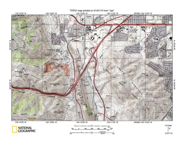
Figure 10: Detailed map of Lena Gulch-Rooney Gulch drainage divide area. United States Geological Survey map digitally presented using National Geographic Society TOPO software.
Figure 10 provides a detailed topographic map of the Lena Gulch-Rooney Gulch drainage divide area seen in less detail in figure 9. The map contour interval for figure 10 is 40 feet. The Front Range eastern flank is located in the west half of figure 10. Green Mountain is located in the east half of figure 10 and Dinosaur Mountain is the north-to-south oriented hogback ridge between Green Mountain and the Front Range. Mount Vernon Creek flows in an east direction from the west edge of figure 10 (south half) through Mount Vernon Canyon to Dinosaur Mountain and then turns in a south direction to flow to the south edge of figure 10 (west of center). South of figure 10 Mount Vernon Creek joins east oriented Bear Creek, which then flows through a water gap across the Dinosaur Mountain hogback ridge to reach the South Platte River. Rooney Gulch is the south oriented drainage route immediately east of Dinosaur Mountain and west of Green Mountain. Rooney Gulch drains to the south center edge of figure 10. South of figure 10 Rooney Gulch drains to Bear Creek. Lena Gulch originates on the west side of Dinosaur Mountain just north of the highway interchange (and north of the south oriented Mount Vernon Creek segment) and drains in a north direction to the hogback ridge north end where it turns in an east-northeast direction to the north edge of figure 10 (east half). North of figure 10 Lena Gulch drains to Clear Creek. A north-to-south oriented through valley on the east side of Dinosaur Mountain links the Lena Gulch valley with the south oriented Rooney Gulch valley while a north-to-south oriented through valley on the west side of Dinosaur Mountain links the north oriented Lena Gulch headwaters valley with the south oriented Mount Vernon Creek valley. The eastern through valley has a floor elevation of approximately 6200 feet while the western through valley floor elevation is approximately 6400 feet. The word approximately is used because both through valleys have been altered by highway construction. Elevations on Green Mountain rise to 6855 feet, elevations on Dinosaur Mountain rise to more than 6800 feet, and elevations in the Front Range rise much higher. These elevations suggest the eastern through valley could be as much as 655 feet deep while the western through valley could be as much as 455 feet deep. These two north-to-south oriented through valleys are water-eroded valleys and were eroded by diverging and converging south oriented flood flow channels as Green Mountain, Dinosaur Mountain, and the Colorado Front Range emerged. Emergence of Green Mountain and Dinosaur Mountain can probably be explained in the context of deep erosion by the south oriented flood flow channels. Emergence of the Front Range probably was related to crustal warping and mountain range uplifts, which were occurring as floodwaters flowed across the region. Uplift of the Front Range probably was responsible for the folding that created the Dinosaur Mountain hogback ridge.
Additional information and sources of maps studied
This essay has provided only a sample of the detailed topographic map evidence supporting the flood erosion interpretation. Many additional illustrations could be provided. Readers are encouraged to look at mosaics of detailed topographic maps to see the abundance of available data. Maps used in this study were created and published by the United States Geologic Survey and can be obtained directly from the United States Geological Survey and/or from dealers offering United States Geological Survey maps. Hard copy maps can also be observed at United States Geological Survey map depositories, which are located throughout the United States and elsewhere. Illustrations used here were created using National Geographic Society TOPO software and digital map data. TOPO software and map data can be obtained from the National Geographic Society and/or dealers offering National Geographic Society digital map data.

Leave a comment