
Abstract:
This essay uses topographic map evidence to interpret landform origins in the Laramie River–Cache la Poudre River drainage divide area in the Colorado Mummy Range and Laramie Mountains. Northeast and north oriented Cache la Poudre River headwaters are linked by deep mountain passes or through valleys with south and southwest oriented Colorado River headwaters, west oriented Michigan River headwaters, and north oriented Laramie River headwaters. Today these through valleys or mountain passes are used to divert water from the Michigan, Laramie, and Colorado River headwaters areas in irrigation ditches and a tunnel to the north, east, and southeast oriented Cache la Poudre River valley. The mountain passes or through valleys were initially eroded by south oriented flood flow moving from the western margin of a thick North American ice sheet (probably in western Canada) to the south and southwest oriented Colorado River valley at a time when Colorado and Wyoming mountain ranges were beginning to emerge. Floodwaters flowed in anastomosing complexes of diverging and converging flood flow channels, which are still visible today. South oriented floodwaters eroded deeper and deeper flood flow channels into the emerging mountain masses, which accounts for the deep mountain passes seen today. Headward erosion of the deeper east and southeast oriented Cache la Poudre River valley beheaded south oriented flood flow channels east of a south oriented flood flow channel on the present day north oriented Laramie River alignment. Floodwaters on north ends of the beheaded flood flow channels reversed flow direction to flow to the much deeper east and southeast oriented Cache la Poudre River valley and to create the present day north, northeast, and east oriented Cache la Poudre River drainage route. Reversed flood flow in the Cache la Poudre River valley captured floodwaters still moving in a south direction on the Laramie River alignment and the captured floodwaters flowed in an east direction across the present day Laramie River-Cache la Poudre River drainage divide. Flood flow on the Laramie River alignment was next beheaded and reversed to flow to the much deeper North Platte River valley in eastern Wyoming. Reversed flood flow on the Laramie River alignment captured southeast and east oriented flood flow moving on the present day west and northwest oriented Michigan River alignment and some of the captured floodwaters also flowed to the newly formed north, east, and southeast oriented Cache la Poudre River drainage route. Subsequently headward erosion of the deep southeast oriented North Platte River valley around the northwest end of the Laramie Mountain (in central Wyoming) beheaded and reversed flood flow routes to the Michigan River alignment and floodwaters on the Michigan River alignment were reversed to create the present day west and northwest oriented Michigan River drainage route.
Preface
The following interpretation of detailed topographic map evidence is one of a series of essays describing similar evidence for all major drainage divides contained within the Missouri River drainage basin and for all major drainage divides with adjacent drainage basins. The research project is interpreting evidence in the context of a previously unexplored deep glacial erosion paradigm, which is fundamentally different from most commonly accepted North American glacial history interpretations. Project essays are listed on the sidebar category list under their appropriate Missouri River tributary drainage basin, Missouri River segment drainage basin (by state), and/or state in which the Missouri River drainage basin is located.
Introduction
The purpose of this essay is to use topographic map interpretation methods to explore the Laramie River- Cache la Poudre River drainage divide area landform origins in the Colorado Mummy Range and Laramie Mountains. Map interpretation methods can be used to unravel many geomorphic events leading up to formation of present-day drainage routes and development of other landform features. While each detailed topographic map feature provides detailed evidence to be explained, the solution must be consistent with explanations for adjacent area map evidence as well as solutions to big picture map evidence puzzles. I invite readers to improve upon my solutions and/or to propose alternate solutions that better explain evidence and are also consistent with adjacent map area and big-picture evidence. Readers may do so either by making comments here or by writing and publishing their own essays and then by leaving a link to those essays in a comment here.
This essay is also exploring a new geomorphology paradigm in which erosional landforms are interpreted as evidence left by immense glacial melt water floods. Implied in that interpretation is the immense floods were derived from a thick North American ice sheet that created a deep “hole” in the North American continent and also melted fast. The previously unexplored paradigm being tested in this and other Missouri River drainage basin landform origins research project essays is a thick North American ice sheet, comparable in thickness to the Antarctic ice sheet, occupied the North American region usually recognized to have been glaciated, and through its weight and erosive actions created a deep North American “hole”. The southwestern rim of that deep “hole” is today preserved in the high Rocky Mountains. The ice sheet through its weight and deep erosion (and perhaps deposition along major south-oriented melt water flow routes) caused significant crustal warping and tectonic change, through its action of melting fast produced immense floods that flowed across the continent, and through its action of melting fast systematically opened up space in the ice sheet created “hole” so headward erosion of newly developed north-oriented drainage systems captured immense south-oriented melt water floods and diverted immense melt water floods north into space the ice sheet had once occupied.
If this previously unexplored paradigm is correct the geographic region explored by this essay should contain evidence of immense floods that were captured by headward erosion of new valley systems so as to cause the floods to flow in a different direction. Ability of this previously unexplored paradigm to explain Laramie River-Cache la Poudre River drainage divide area landform evidence in the Colorado Mummy Range and Laramie Mountains will be regarded as evidence supporting the “thick ice sheet that melted fast” paradigm.
Laramie River- Cache la Poudre River drainage divide area location map
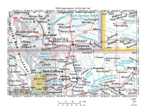
Figure 1: Laramie River-Cache la Poudre River drainage divide area location map (select and click on maps to enlarge). National Geographic Society map digitally presented using National Geographic Society TOPO software.
Figure 1 provides a location map for the Laramie River-Cache la Poudre River drainage divide area in the Colorado Mummy Range and Laramie Mountains and illustrates a region in northern Colorado in the south half with the southeast corner of Wyoming to the north and western Nebraska in the northeast corner. Rocky Mountain National Park is located in the southwest quadrant of figure 1. The Medicine Bow Mountains extend in a north-northwest direction from near the Rocky Mountain National Park northwest corner to the west edge of figure 1 (near northwest corner). The Laramie Mountains (not labeled in figure 1) are located just east of Laramie, Wyoming and extend in a south direction from the north edge of figure 1 to region near Rocky Mountain National Park where the Laramie Mountains merge with the Colorado Mummy Range and Front Range (not labeled in figure 1). The region between the Medicine Bow Mountains and Laramie Mountains in Wyoming is the Laramie Basin (also not labeled). The North Platte River (not labeled in figure 1) flows in a north-northwest direction on the west side of the Medicine Bow Mountains to the west edge of figure 1 (north of center) and west and north of figure 1 flows in a north, northeast, and east direction around the northwest end of the Laramie Mountains and then in a southeast direction to cross the northeast corner of figure 1. The Laramie River originates near Clarks Peak at the south end of the Medicine Bow Mountains and flows in a north-northwest direction on the east side of the Medicine Bow Mountains into Wyoming and then turns to flow in a northeast and north direction to the north edge of figure 1 (west half). North of figure 1 the Laramie River turns to flow in an east and northeast direction across the Laramie Mountains and then to join the southeast oriented North Platte River. The South Platte River flows in a north and northeast direction from the south center edge of figure 1 to near Greeley, Colorado and then turns to flow in a southeast, northeast, and southeast direction to Fort Morgan, Colorado. From Fort Morgan the South Platte River flows in a northeast direction to the east edge of figure 1 (south half) and east of figure 1 flows in a northeast and east direction to join the North Platte River in western Nebraska and to form the Nebraska Platte River with water eventually reaching the Gulf of Mexico. The Cache la Poudre River originates in northern Rocky Mountain National Park and flows in a north direction before turning in an east, southeast, and east direction to join the South Platte River near Greeley. The Colorado River (not shown or labeled in figure 1) originates in Rocky Mountain National Park just south of the Cache la Poudre River headwaters and flows in a south direction on the west side of Rocky Mountain National Park and south of figure 1 turns in a southwest direction with water eventually reaching the Pacific Ocean. The Laramie River-Cache la Poudre River drainage divide area in the Colorado Laramie Mountains is located just north of Rocky Mountain National Park and is east of the south end of the Medicine Bow Mountains.
While based on present day topography it is difficult to imagine the North Platte and South Platte River drainage routes and their tributary drainage routes, including the Laramie and Cache la Poudre River drainage routes, developed during immense melt water floods from the western margin of a thick North American ice sheet. Floodwaters flowed from western Canada to and across Wyoming and Colorado at a time when present day Wyoming and Colorado mountain ranges were beginning to emerge. Mountain ranges emerged as ice sheet related crustal warping raised mountain masses and as floodwaters deeply eroded surrounding regions. At first floodwaters flowed in south directions, but later flood flow directions changed and even reversed as crustal warping raised mountain ranges and plateau areas and as deep valleys eroded headward to capture the immense melt water floods. The present day north oriented South Platte River drainage route south of Greeley originated as a south oriented flood flow channel and the east and southeast oriented Cache la Poudre River valley eroded headward from that flood flow channel to capture south oriented floodwaters in the emerging mountains to the west. The north oriented Cache la Poudre River headwaters route was created by a reversal of flood flow on the north end of a south oriented flood flow channel beheaded by headward erosion of the deeper east oriented Cache la Poudre River valley. Headward erosion of the deeper South Platte River valley from western Nebraska beheaded the south oriented flood flow channel near Greeley. Floodwaters on the north end of the beheaded flood flow channel reversed flow direction to flow to the much deeper South Platte River valley (see Cache la Poudre River-Big Thompson River drainage divide area essay for additional details). The present day north oriented Laramie River drainage route originated as south oriented flood flow channels. Those south oriented flood flow channels were beheaded and reversed by headward erosion of the deep east and northeast oriented Laramie River valley, which eroded headward across the emerging Laramie Mountains (north of figure 1) from the actively eroding North Platte River valley. Floodwaters on north ends of the beheaded flood flow channels reversed flow directions to create the north oriented Laramie River drainage route. Headward erosion of the deep southeast oriented North Platte River valley around the northwest end of the Laramie Mountains beheaded and reversed south oriented flood flow channels west of the Laramie and Medicine Bow Mountains to create the north oriented North Platte River drainage route west of those mountains. These massive flood flow reversals were aided by ice sheet related crustal warping that was raising the regional mountain ranges and the entire region.Details of these flood flow captures and reversals are illustrated and described in the more than 50 Missouri River drainage basin landform origins research project essays related to the North and South Platte Rivers and their tributaries including the Laramie and Cache la Poudre Rivers.
Detailed location map for Laramie River-Cache la Poudre River drainage divide area

Figure 2: Detailed location map Laramie River-Cache la Poudre River drainage divide area. United States Geological Survey map digitally presented using National Geographic Society TOPO software.
Figure 2 provides a detailed location map for the Laramie River-Cache la Poudre River drainage divide area in the Colorado Mummy Range and Laramie Mountains. The red-brown colored area straddling the south center edge of figure 2 is Rocky Mountain National Park. The east-west continental divide extends in a north-northeast direction along the crest of the Never Summer Mountains (on west side of Rocky Mountain National Park) to the northwest corner of Rocky Mountain National Park and then turns in a south-southeast direction to the south center edge of figure 2. The Mummy Range straddles the Rocky Mountain National Park northern boundary and the Laramie Mountains are north of the Mummy Range. All regions in figure 2 north of the continental divide line drain to the Gulf of Mexico while the region enclosed by that continental divide line is drained by south oriented headwaters of the Colorado River with water eventually reaching the Pacific Ocean. Cache la Poudre River headwaters originate on the continental divide and flow in a northeast, north, northwest, north, and northeast direction to near the center of figure 2 where the Cache la Poudre River turns to flow in an east and southeast direction to the east edge of figure 2 (near Fort Collins). East of figure 2 the Cache la Poudre River flows in a southeast and east direction to join the southeast, northeast, southeast, and northeast oriented South Platte River. Chambers Lake is located near the south-southeast end of the Medicine Bow Mountains and north of the northwest corner of Rocky Mountain National Park. The Laramie River originates at Chambers Lake and flows in a north and northwest direction between the Laramie Mountains and the Medicine Bow Mountains to the north edge of figure 2 (west of center). North of figure 2 the Laramie River flows in a northeast and north direction in the Laramie Basin and then in an east and northeast direction across the Wyoming Laramie Mountains to reach the southeast oriented North Platte River. Cameron Pass is a labeled pass at the south-southeast end of the Medicine Bow Mountains and just north of the northwest corner of Rocky Mountain National Park. The west and northwest oriented drainage route just south of Cameron Pass is the Michigan River, which flows to the north oriented North Platte River near the northwest corner of figure 2. North of figure 2 the North Platte River flows in a north and northeast direction into central Wyoming and then around the northwest end of the Laramie Mountains before turning in a southeast direction on the east side of the Wyoming Laramie Mountains. The Laramie River-Cache la Poudre River drainage divide area investigated in this essay is actually the drainage divide between the Laramie River, Cache la Poudre River, Michigan River, and Colorado River with each river today flowing in very different directions, although water in the Laramie, Cache la Poudre, and Michigan Rivers eventually converges in the Nebraska Platte River while Colorado River water ends up in the Pacific Ocean.
Cache la Poudre River-Colorado River drainage divide area
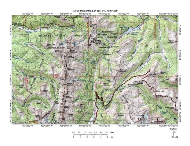
Figure 3: Cache la Poudre-Colorado River drainage divide area. United States Geological Survey map digitally presented using National Geographic Society TOPO software.
Figure 3 provides a topographic map of Cache la Poudre-Colorado River drainage divide area. The map contour interval for figure 3 is 50 meters. The east-west continental divide extends in a northeast, north, and northeast direction along the crest of the Never Summer Mountains from the south edge of figure 3 (west half) to north center area of figure 2 and then turns in a southeast direction to La Poudre Pass before turning in a south direction to Milner Pass and then in a south-southeast direction to the south edge of figure 3. The Colorado River originates near La Poudre Pass and flows in a south-southwest and south direction to the south center edge of figure 3. South of figure 3 the Colorado River turns in a southwest direction to eventually reach the Pacific Ocean. The Cache la Poudre River originates near Milner Pass and flows in a northeast and north direction to the north edge of figure 3 (near northeast corner). North of figure 3 the Cache la Poudre River flows in a northwest, north, and northeast direction before turning to flow in an east, southeast, and east direction to join the South Platte River with water eventually reaching the Gulf of Mexico. Milner Pass is a through valley linking the Cache la Poudre River valley with the Colorado River valley and has an elevation of 3279 meters. Specimen Mountain to the north rises to 3807 meters and the continental divide (south of figure 3) rises to more than 3900 meters suggesting Milner Pass is more than 520 meters deep. Milner Pass is a water-eroded valley and was eroded by south oriented flood flow in the present day north oriented Cache la Poudre River valley moving to the actively eroding Colorado River valley. La Poudre Pass to the north links the south-southwest oriented Colorado River headwaters valley with northeast oriented La Poudre Pass Creek, which flows to the north oriented Cache la Poudre River and has a floor elevation of between 3100 and 3150 meters. Lulu Mountain to the west has an elevation of 3727 meters suggesting La Poudre Pass is approximately 600 meters deep. La Poudre Pass was also eroded by south oriented flood flow moving from the present day north oriented Cache la Poudre River valley to the actively eroding south oriented Colorado River valley. The northeast oriented La Poudre Pass Creek valley originated as a diverging flood flow channel from a south and southeast oriented flood flow channel on the present day northeast and north oriented Cache la Poudre River headwaters valley. The two diverging flood flow channels converged again in the Colorado River valley near the south center edge of figure 3. The Michigan River originates at Snow Lake (west of Lulu Mountain, which is west of La Poudre Pass) and flows in an east-northeast, north, and west direction to the west edge of figure 3 (near northwest corner). West and north of figure 3 the Michigan River flows in a west and northwest direction to join the north oriented North Platte River, which flows into central Wyoming and then around the north end of the Laramie Mountains before turning in a southeast direction with water eventually reaching the Gulf of Mexico. An unnamed pass between Lulu Mountain and Iron Mountain links the west oriented Michigan River valley with the southeast oriented Neola Creek valley, which drains to northeast oriented La Poudre Pass Creek near La Poudre Pass. The unnamed pass has an elevation of between 3400 and 3450 meters. Elevations on Iron Mountain reach 3738 meters suggesting the unnamed pass is approximately 280 meters deep. The unnamed pass is also a water-eroded valley and was probably eroded by east oriented flood flow flowing from the present day north oriented North Platte River alignment to the actively eroding Colorado River valley and later after flood flow in the Cache la Poudre River valley had been beheaded and reversed probably flowing to reversed flood flow in the La Pass Creek and Cache la Poudre River valleys.
Detailed map of La Poudre Pass Creek-Colorado River drainage divide area
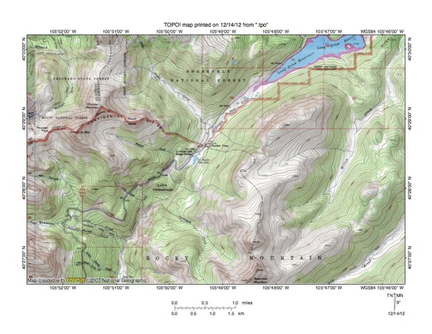
Figure 4: Detailed map of La Poudre Pass Creek-Colorado River drainage divide area. United States Geological Survey map digitally presented using National Geographic Society TOPO software.
Figure 4 provides a detailed topographic map of the La Poudre Pass Creek-Colorado River drainage divide area seen in less detail in figure 5. The map contour interval for figure 4 is 40 feet. La Poudre Pass is near the center of figure 4 and has an elevation of 10,186 feet. The east-west continental divide extends in an east direction from the west edge of figure 4 (north of center) to La Poudre Pass and then in an east and south direction to the south edge of figure 4 (at Specimen Mountain). The Cache la Poudre River flows in a northeast direction across the southeast corner of figure 4. East of figure 4 the Cache la Poudre River turns to flow in a north, northwest, north, and northeast direction and then in an east, southeast, and east direction to join the South Platte River with water eventually reaching the Gulf of Mexico. The Colorado River originates at La Poudre Pass Lake (on south side of La Poudre Pass) and flows in a south-southwest and south direction to the south edge of figure 4 (west half). South and west of figure 4 the Colorado River flows in a southwest direction to eventually reach the Pacific Ocean. La Poudre Pass Creek originates on the northeast side of La Poudre Pass and flows to Long Draw Reservoir and then to the north oriented Cache la Poudre River. Neola Creek is the southeast oriented La Poudre Pass Creek tributary flowing towards La Poudre Pass. Lulu Mountain to the west of La Poudre Pass has an elevation of 12,228 feet and Specimen Mountain near the south edge of figure 4 rises to 12,489 feet suggesting La Poudre Pass is approximately 2000 feet deep. La Poudre Pass was eroded by south oriented flood flow moving from the present day north oriented Cache la Poudre River and La Poudre Pass Creek valley to the south oriented Colorado River valley. Headward erosion of the east oriented Cache la Poudre River valley (north and east of figure 4) beheaded south oriented flood flow channels and floodwaters on the north ends of the beheaded flood flow channels (there were diverging and converging flood flow channels involved) reversed flow direction to create the north oriented Cache la Poudre River and La Poudre Pass Creek drainage routes. The flood flow reversal was aided by ice sheet related crustal warping that was raising mountains in the region. The Grand Ditch irrigation canal on the west side of the Colorado River valley moves water from Colorado River tributary valleys to the Cache la Poudre drainage basin. Long Draw Reservoir stores this Colorado River water until such time as the water is needed downstream in the Cache la Poudre River valley.
Joe Wright Creek-Michigan River drainage divide area

Figure 5: Joe Wright Creek-Michigan River drainage divide area. United States Geological Survey map digitally presented using National Geographic Society TOPO software.
Figure 5 illustrates the Joe Wright Creek-Michigan River drainage divide area north and west of figure 3 and there is an overlap area with figure 3. The map contour interval for figure 5 is 50 meters. The Cache la Poudre River flows in a north, northwest, and north direction from the southeast corner of figure 5 to the north edge of figure 5 (east half). North of figure 5 the Cache la Poudre River flows in a northeast, east, southeast, and east direction to join the South Platte River. La Poudre Pass is near the south edge of figure 5 (east of center). La Poudre Pass Creek flows in a northeast direction from La Poudre Pass to Long Draw Reservoir and then to join the north oriented Cache la Poudre River. Snow Lake is north of the south center edge of figure 5. The Michigan River originates at Snow Lake and flows in an east-northeast, north, west, and northwest direction to the west edge of figure 5. West and north of figure 5 the Michigan River flows in a northwest direction to join the north oriented North Platte River, which flows around the northwest end of the Laramie Mountains and then in a southeast direction to join the South Platte River in western Nebraska. North of Snow Lake and north of the west oriented Michigan River is Cameron Pass, which links a south oriented Michigan River tributary valley with the north-northeast oriented Joe Wright Creek valley. Joe Wright Creek flows to Chambers Lake, which straddles the north edge of figure 5 (east of center). North of figure 5 the Laramie River originates at Chambers Lake and flows in a north direction, but Joe Wright Creek also continues in a northeast direction to join the north oriented Cache la Poudre River. The Medicine Bow Mountains are the north-northwest oriented mountains west of Joe Wright Creek. Cameron Pass has an elevation of between 3100 and 3150 meters. Diamond Peaks to the west rise to 3612 meters while Iron Mountain to the east rises to 3738 meters suggesting Cameron Pass is approximately 460 meters deep. Cameron Pass is a water-eroded valley and was initially eroded by south oriented flood flow from the present day north oriented Laramie River and Cache la Poudre alignments, which initially moved to the south oriented Colorado River valley. However, after headward erosion of the east oriented Cache la Poudre River valley (north and east of figure 5) beheaded and reversed flood flow to create the north oriented Cache la Poudre River headwaters drainage routes and flood flow on the Laramie River alignment had been beheaded and reversed there was a reversal of flood flow in the Cameron Pass through valley. Floodwaters west of the Medicine Bow Mountains were still flowing in a south direction and southeast and east oriented floodwaters on the Michigan River alignment then flowed in a north direction through Cameron Pass to the newly created north oriented Cache la Poudre and Laramie River drainage routes. Subsequently flood flow west of the Medicine Bow Mountains was beheaded and reversed to create the west and northwest oriented Michigan River drainage route. Since that time crustal warping has probably raised elevations and valley glaciers probably have deepened some of the valleys to produce the landforms seen today.
Detailed map of Joe Wright Creek-Michigan River drainage divide area
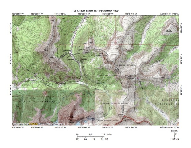
Figure 6: Detailed map of Joe Wright Creek-Michigan River drainage divide area. United States Geological Survey map digitally presented using National Geographic Society TOPO software.
Figure 6 provides a detailed topographic map of the Joe Wright Creek-Michigan River drainage divide area seen in less detail in figure 5. The map contour interval for figure 6 is 40 feet. La Poudre Pass Creek flows in a northeast direction across the southeast corner of figure 6 and is joined at the southeast corner of figure 6 by southeast oriented Neola Creek. West of figure 6 La Poudre Pass Creek flows to the north oriented Cache la Poudre River, which eventually joins the South Platte River with water ultimately reaching the Gulf of Mexico. La Poudre Pass and the Colorado River headwaters are located just south of the southeast corner of figure 6. South and west of figure 6 the Colorado River eventually flows to the Pacific Ocean. The Michigan Lakes are located near the south edge of figure 6 (slightly west of center). The Michigan River flows in an east-northeast direction from the Michigan Lakes before turning in a north and then west direction to flow to the west edge of figure 6 (south half). West of figure 6 the Michigan River turns to flow in a northwest direction to join the north oriented North Platte River, which after flowing around the northwest end of the Laramie Mountains joins the South Platte River in western Nebraska. Cameron Pass is located north and west of the center of figure 6 in a deep north to south oriented valley linking the west oriented Michigan River valley with the north edge of figure 6 (slightly west of center). North of Cameron Pass the valley is drained by north oriented Joe Wright Creek, which north of figure 6 flows to Chambers Lake and then in a northeast direction to join the north oriented Cache la Poudre River. However, Chambers Lake is also drained by the north oriented Laramie River so the Joe Wright Creek valley actually leads to both the Laramie River and the Cache la Poudre River valleys. Cameron Pass has an elevation of 10,279 feet. Diamond Peaks to the west rise to 11,852 feet and Iron Mountain to the east rises to 12,285 feet suggesting Cameron Pass is approximately 1600 feet deep. Valley glaciers have probably deepened and altered some of the valleys in figure 6, however the glaciers did not erode new valleys, which means the Cameron Pass through valley is a water-eroded valley. The Cameron Pass through valley was probably initiated as a south oriented flood flow channel moving floodwaters from the present day north oriented Laramie River and Cache la Poudre River alignments to the south oriented Colorado River valley. South oriented floodwaters on the present day north oriented North Platte River alignment (west of the Laramie and Medicine Bow Mountains) also moved in a southeast and east direction on the Michigan River alignment. South oriented flood flow on the present day north oriented Joe Wright Creek alignment was beheaded and reversed prior to the reversal of flood flow on the Michigan River alignment. As a result southeast and east floodwaters on the Michigan River alignment were captured by the reversed flow on the Joe Wright Creek alignment and flowed to the newly formed north oriented Laramie River and Cache la Poudre River drainage routes. Subsequently floodwaters on the Michigan River alignment were beheaded and reversed to create the west and northwest oriented Michigan River drainage route. Valley glaciers probably have deepened the Michigan River valley and ice sheet related crustal warping has probably uplifted the region since that time. Note the irrigation canal, which moves water from the Michigan River drainage basin across Cameron Pass to the Joe Wright Creek drainage basin and north of figure 6 to the Cache la Poudre River.
Laramie River-Joe Wright Creek drainage divide area
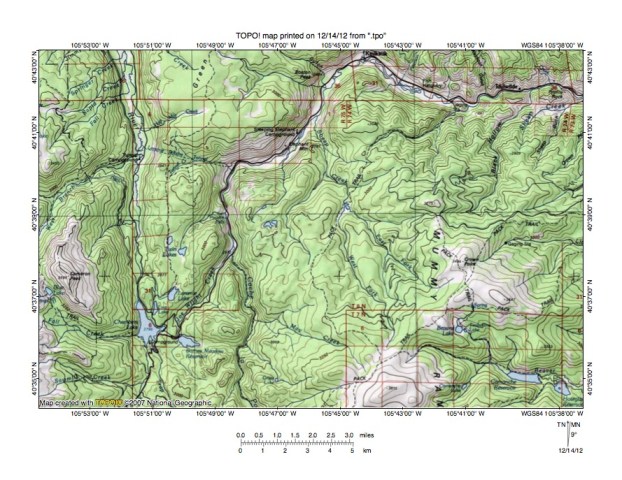
Figure 7: Laramie River-Joe Wright Creek drainage divide area. United States Geological Survey map digitally presented using National Geographic Society TOPO software.
Figure 7 illustrates the Laramie River-Joe Wright Creek drainage divide area north and east of figure 5 and includes an overlap area with figure 5. The map contour interval for figure 7 is 50 meters. Chambers Lake is located in the southwest quadrant of figure 7. The Laramie River flows in a north direction from Chambers Lake to the north edge of figure 7 (west half). North of figure 7 the Laramie River flows in a north, northeast, and north direction to and across the Wyoming Laramie Basin and then in an east and northeast direction across the Laramie Mountains before flowing to the southeast oriented North Platte River. The Cache la Poudre River flows in a north and northeast direction from the south edge of figure 7 (west of figure 7) to Kinikinik near the north edge of figure 7 and then in an east-southeast and east direction to the east edge of figure 7 (near northeast corner). East of figure 7 the Cache la Poudre River flows in an east, southeast, and east direction to join the southeast, northeast, southeast, and northeast oriented South Platte River, which eventually joins the North Platte River in western Nebraska. Mountains south of the Cache la Poudre River in the east half of figure 7 are the Mummy Range with the Laramie Mountains being located north of the Mummy Range. Joe Wright Creek flows in a north-northeast direction from the south edge of figure 7 to Chambers Lake and then in a northeast direction to the north and northeast oriented Cache la Poudre River. Chambers Lake is unusual in that it has outlets draining to two different rivers. As previously discussed the north oriented Laramie River and the north oriented Cache la Poudre River valleys originated as south oriented flood flow channels and the northeast oriented Joe Wright Creek valley segment originated as a southwest oriented flood flow channel diverging from the flood flow channel on the Cache la Poudre River alignment and then converging with the flood flow channel on the Laramie River alignment. Another diverging and converging flood flow channel probably used the through valley where Twin Lakes are now located. Headward erosion of the deep east oriented Cache la Poudre River valley beheaded flood flow on the present day north oriented Cache la Poudre River alignment, which caused a reversal of flood flow to create the north oriented Cache la Poudre River drainage route. A similar reversal of flood flow subsequently took place in the Laramie River valley. These reversals in flood flow on the east side of the Medicine Bow Mountains captured floodwaters still moving in a south direction on the west side of the Medicine Bow Mountains. The captured floodwaters moved in a southeast and east direction on the present day west and northwest oriented Michigan River alignment and then in a north and northeast direction in the Cameron Pass valley to the Joe Wright Creek alignment and then to the newly reversed Laramie River and Cache la Poudre River drainage routes. Crustal warping that was raising mountains as floodwaters flowed across the region contributed to the flood flow reversals and to the erosion of deep valleys. Eventually headward erosion of the southeast oriented North Platte River around the northwest end of the Laramie Mountains in central Wyoming beheaded and reversed flood flow routes west of the Laramie and Medicine Bow Mountains and created the north oriented North Platte River and west and northwest oriented Michigan River drainage routes and ended flood flow in the region seen in figure 7.
Detailed map of Laramie River-Joe Wright Creek drainage divide area
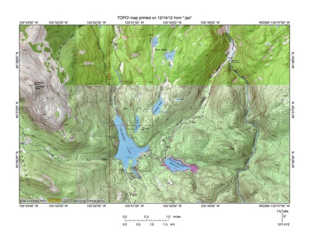
Figure 8: Detailed map of Laramie River-Joe Wright Creek drainage divide area. United States Geological Survey map digitally presented using National Geographic Society TOPO software.
Figure 8 provides a detailed topographic map of the Laramie River-Joe Wright Creek drainage divide area seen in less detail in figure 7. The map contour interval for figure 8 is 40 feet. Chambers Lake is south and west of the center of figure 8. The Laramie River flows in a north direction from Chambers Lake to the north edge of figure 8 (west of center). North of figure 8 the Laramie River flows in a north, northeast, and north direction into and across the Wyoming Laramie Basin before turning in an east and northeast direction to flow across the Laramie Mountains and to join the southeast oriented North Platte River. The Cache la Poudre River flows in a north direction from the south edge of figure 8 (east half) to the north edge of figure 8 (east half). North of figure 8 the Cache la Poudre River flows in a northeast, east, southeast, and east direction to join the southeast, northeast, southeast, and northeast oriented South Platte River, which eventually joins the southeast oriented North Platte River in western Nebraska. Joe Wright Creek is the westernmost of the two north oriented streams flowing from the south edge of figure 8 to Chambers Lake and then flows in an east-southeast direction to near Barnes Meadow Reservoir before turning in a northeast direction to join the north oriented Cache la Poudre River near the Big South Campground in the northeast quadrant of figure 8. The Skyline Ditch on the west side of the Laramie River valley moves water from the West Fork Laramie River (north of figure 8) to Chambers Lake where the water is diverted to the Joe Wright Creek valley and then to the Cache la Poudre River. The northeast oriented Joe Wright Creek valley originated as southwest oriented flood flow channel diverging from a south oriented flood flow channel on the present day north oriented Cache la Poudre River alignment and converging with a south oriented flood flow channel on the present day north oriented Laramie River alignment to flow in a south direction in the Cameron Pass valley to and across the Michigan River headwaters area and then to the south oriented Colorado River valley. Reversals of flood flow, which were not simultaneous, created the north oriented Cache la Poudre River and Laramie River drainage routes and captured southeast and east oriented flood flow moving on the present day west and northwest oriented Michigan River alignment. The captured flood flow moved in a north direction in the Cameron Pass valley to the Chambers Lake area where the north oriented flood flow channel split into two diverging flood flow channels, with one flood flow channel continuing in a north direction on the Laramie River alignment while the other flood flow channel proceeded in a northeast direction to converge with reversed drainage in the newly reversed and north oriented Cache la Poudre River valley.
Laramie River-Cache la Poudre River drainage divide area
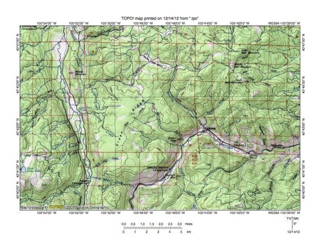
Figure 9: Laramie River-Cache la Poudre River drainage divide area. United States Geological Survey map digitally presented using National Geographic Society TOPO software.
Figure 9 illustrates the Laramie River-Cache la Poudre River drainage divide area north and slightly west of figure 7 and there is an overlap area with figure 7. The map contour interval for figure 9 is 50 meters. The Laramie River flows in a north direction from the south edge of figure 9 (west half) to the north edge of figure 9 (west half). North of figure 9 the Laramie River flows in a north, northeast, and north direction into and across the Wyoming Laramie Basin before turning in an east and northeast direction to flow across the Laramie Mountains to the southeast oriented North Platte River. The Cache la Poudre River flows in a north and northeast direction from the south edge of figure 9 (west of center) to Kinikinik and then in a southeast and east direction to the east edge of figure 9 (south of center). East of figure 9 the Cache la Poudre River flows in an east, southeast, and east direction to join the southeast, northeast, southeast, and northeast oriented South Platte River, which eventually joins the southeast North Platte River in western Nebraska. Roaring Creek is a south and southeast oriented stream joining the Cache la Poudre River at Kinikinik and the East Fork is a southwest oriented stream also joining the Cache la Poudre River at Kinikinik and could be considered a barbed tributary. Williams Gulch is one of two southeast oriented tributaries joining the northeast oriented Cache la Poudre segment. These barbed tributaries are relics of south oriented flood flow routes that once crossed the region prior to the reversals of flood flow that created the present day north oriented drainage routes. Nunn Creek originates in the Nunn Creek Basin (in north center area of figure 9) and flows in a southwest, west, and north direction to join the Laramie River near the north edge of figure 9. The north oriented Nunn Creek segment drains the north end of a 150-200 meter deep north-to-south oriented through valley on the east side of Middle Mountain. The through valley was probably eroded as a diverging and converging flood flow channel at a time when floodwaters flowed in the Laramie River valley. As previously described the Laramie River valley was initiated by south oriented flood flow, but was later reversed. The Laramie-Poudre Tunnel crosses the Laramie River-Cache la Poudre River drainage divide near the south edge of figure 9. The Laramie River valley floor elevation is higher than the Cache la Poudre River valley floor elevation and water flows through the tunnel from the Laramie River to the Cache la Poudre River. The tunnel is located under a west to east oriented through valley linking the Laramie River valley with the Cache la Poudre River valley. As previously mentioned south oriented flood flow on the present day north oriented Cache la Poudre River alignment was beheaded and reversed before south oriented flood flow on the Laramie River alignment was beheaded and reversed. The Tunnel Creek through valley was used by south oriented flood on the Laramie River alignment that was captured by the newly reversed Cache la Poudre River drainage route. After the reversal of flood flow on the Laramie River alignment the east oriented flood flow channel was beheaded as the newly formed north oriented Laramie River valley eroded a deeper valley, but the east oriented through valley exists and is now being used to divert water from the Laramie River to the Cache la Poudre River .
Detailed map of Laramie River-Tunnel Creek drainage divide area
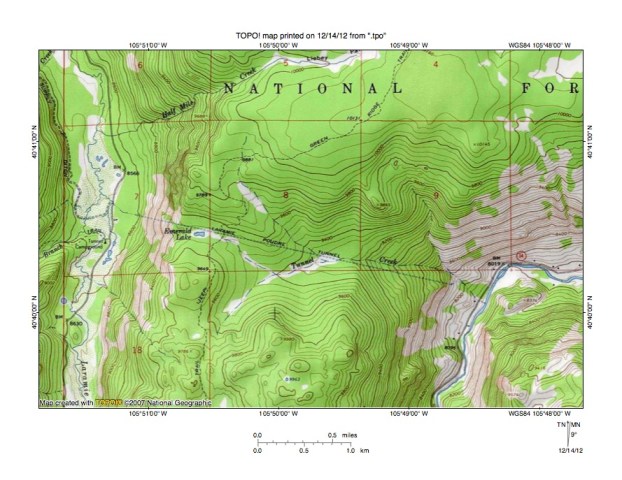
Figure 10: Detailed map of Laramie River-Tunnel Creek drainage divide area. United States Geological Survey map digitally presented using National Geographic Society TOPO software.
Figure 10 provides a detailed topographic map of the Laramie River-Tunnel Creek drainage divide area seen is less detail in figure 9. The map contour interval for figure 10 is 40 feet. The Laramie River flows in a north direction from near the southwest corner of figure 10 to near the northwest corner of figure 10. North of figure 10 the Laramie River flows into Wyoming and eventually reaches the southeast oriented North Platte River. The Cache la Poudre River flows in a north-northeast and east direction from the south edge of figure 10 (east half) to the east edge of figure 10 (south of center). East of figure 10 the Cache la Poudre River flows in a northeast, southeast, east, southeast, and east direction to join the South Platte River, which joins the North Platte River in western Nebraska. The Laramie-Poudre Tunnel is shown extending from section 7 across the south margin of section 8 and the southwest corner of section 9 to end in Cache la Poudre River valley. The Laramie River valley floor elevation at the west end of the Laramie-Poudre Tunnel is between 8560 and 8600 feet. The Cache la Poudre River valley floor elevation east of the east end of the Laramie-Poudre Tunnel is between 8000 and 8040 feet or more than 500 feet lower than the Laramie River valley elevation. The Laramie-Poudre Tunnel crosses the Laramie River-Cache la Poudre River drainage divide beneath a west to east oriented through valley that once moved south oriented floodwaters moving in the present day north oriented Laramie River valley to what was at that time the newly reversed Cache la Poudre River valley. South oriented flood flow in the Cache la Poudre River valley was beheaded and reversed by headward erosion of the much deeper east and southeast oriented Cache la Poudre River valley (north and east of figure 10). The deeper Cache la Poudre River valley then captured south oriented flood flow from the adjacent south oriented flood flow channel on the present day north oriented Laramie River alignment. The captured floodwaters moved in an east direction along the alignment now used by the Laramie-Poudre Tunnel. The through valley floor elevation at Emerald Lake is between 9520 and 9560 feet. Elevations south of the through valley rise to more than 10,040 feet and elevations to the north of the through valley rise to 10,131 feet suggesting the through valley is approximately 500 feet deep. While the adjacent Laramie River and Cache la Poudre River valleys are much deeper the through valley is a significant landform and provides evidence of a former flood flow route, which is being used again to divert water from the Laramie River valley to the Cache la Poudre River valley.
Additional information and sources of maps studied
This essay has provided only a sample of the detailed topographic map evidence supporting the flood erosion interpretation. Many additional illustrations could be provided. Readers are encouraged to look at mosaics of detailed topographic maps to see the abundance of available data. Maps used in this study were created and published by the United States Geologic Survey and can be obtained directly from the United States Geological Survey and/or from dealers offering United States Geological Survey maps. Hard copy maps can also be observed at United States Geological Survey map depositories, which are located throughout the United States and elsewhere. Illustrations used here were created using National Geographic Society TOPO software and digital map data. TOPO software and map data can be obtained from the National Geographic Society and/or dealers offering National Geographic Society digital map data.

Leave a comment