
Abstract:
This essay uses topographic map evidence to interpret landform origins in the North Platte River-Lodgepole Creek drainage divide area in Morrill and Cheyenne Counties, Nebraska. Morrill and Cheyenne Counties are located in the Nebraska Panhandle with Morrill County north of Cheyenne County and the northeast corner of Colorado located south of Cheyenne County. The North Platte River flows in a southeast direction across Morrill County and the South Platte River flows in a northeast direction in the northeast corner Colorado just south of Cheyenne County. The North and South Platte Rivers join in Nebraska and east of Morrill and Cheyenne Counties to form the Platte River, which then flows across Nebraska to join the Missouri River. Lodgepole Creek flows in an east, east-southeast, and east direction across Cheyenne County and east of Cheyenne County turns to flow in a southeast direction to join the northeast oriented South Platte River. Lodgepole Creek tributaries from the north are oriented in southeast, east, and southeast directions. North Platte River tributaries include southeast, north-northeast, and north oriented Rush Creek and east and north oriented Pumpkin Creek. Lawrence Fork is a northeast oriented Pumpkin Creek tributary and is located in a deep valley, which has beheaded southeast oriented Rush Creek and Lodgepole Creek tributary headwaters. Drainage routes in Morrill and Cheyenne Counties are interpreted in the context of immense south and southeast oriented floods, which once flowed across the region. Floodwaters were derived from the western margin of a thick North American ice sheet and flowed from western Canada to and across western Nebraska. Headward erosion of the northeast oriented South Platte River valley captured south and southeast oriented flood flow, which had been moving to what was then the newly eroded Republican River valley and diverted the floodwaters to the newly eroded Platte River valley. Headward erosion of the east and southeast oriented Lodgepole Creek valley from the newly eroded South Platte River next captured southeast oriented flood flow, which had been moving to the newly eroded South Platte River valley. The north-northeast and north oriented Rush Creek valley was next created by reversals of flood flow triggered by headward erosion of the southeast oriented North Platte River valley (from the newly eroded Platte River valley) and captured southeast oriented flood flow in northern Cheyenne County to create the southeast, north-northeast, and north oriented Rush Creek drainage route. Headward erosion of the deep southeast oriented North Platte River valley and its tributary east oriented Pumpkin Creek valley next beheaded flood flow routes to the newly formed Rush Creek drainage route with captured floodwaters creating north oriented North Platte River and Pumpkin Creek tributary drainage routes. Headward erosion of the deep northeast oriented Lawrence Fork valley next beheaded southeast oriented flood flow routes to the newly formed Rush Creek drainage route and also to actively developing southeast oriented Lodgepole Creek tributary drainage routes. Floodwaters on northwest ends of beheaded flood flow routes reversed flow direction to flow into the deeper Lawrence Fork valley and to create northwest and north-northwest oriented Lawrence Fork tributary drainage routes.
Preface
The following interpretation of detailed topographic map evidence is one of a series of essays describing similar evidence for all major drainage divides contained within the Missouri River drainage basin and for all major drainage divides with adjacent drainage basins. The research project is interpreting evidence in the context of a previously unexplored deep glacial erosion paradigm, which is fundamentally different from most commonly accepted North American glacial history interpretations. Project essays are listed on the sidebar category list under their appropriate Missouri River tributary drainage basin, Missouri River segment drainage basin (by state), and/or state in which the Missouri River drainage basin is located.
Introduction
The purpose of this essay is to use topographic map interpretation methods to explore the North Platte River-Lodgepole Creek drainage divide area landform origins in Morrill and Cheyenne Counties, Nebraska. Map interpretation methods can be used to unravel many geomorphic events leading up to formation of present-day drainage routes and development of other landform features. While each detailed topographic map feature provides detailed evidence to be explained, the solution must be consistent with explanations for adjacent area map evidence as well as solutions to big picture map evidence puzzles. I invite readers to improve upon my solutions and/or to propose alternate solutions that better explain evidence and are also consistent with adjacent map area and big-picture evidence. Readers may do so either by making comments here or by writing and publishing their own essays and then by leaving a link to those essays in a comment here.
This essay is also exploring a new geomorphology paradigm in which erosional landforms are interpreted as evidence left by immense glacial melt water floods. Implied in that interpretation is the immense floods were derived from a thick North American ice sheet that created a deep “hole” in the North American continent and also melted fast. The previously unexplored paradigm being tested in this and other Missouri River drainage basin landform origins research project essays is a thick North American ice sheet, comparable in thickness to the Antarctic ice sheet, occupied the North American region usually recognized to have been glaciated, and through its weight and erosive actions created a deep North American “hole”. The southwestern rim of that deep “hole” is today preserved in the high Rocky Mountains. The ice sheet through its weight and deep erosion (and perhaps deposition along major south-oriented melt water flow routes) caused significant crustal warping and tectonic change, through its action of melting fast produced immense floods that flowed across the continent, and through its action of melting fast systematically opened up space in the ice sheet created “hole” so headward erosion of newly developed north-oriented drainage systems captured immense south-oriented melt water floods and diverted immense melt water floods north into space the ice sheet had once occupied.
If this previously unexplored paradigm is correct the geographic region explored by this essay should contain evidence of immense floods that were captured by headward erosion of new valley systems so as to cause the floods to flow in a different direction. Ability of this previously unexplored paradigm to explain North Platte River-Lodgepole Creek drainage divide area landform evidence in Morrill and Cheyenne Counties, Nebraska will be regarded as evidence supporting the “thick ice sheet that melted fast” paradigm.
North Platte River-Lodgepole Creek drainage divide area location map
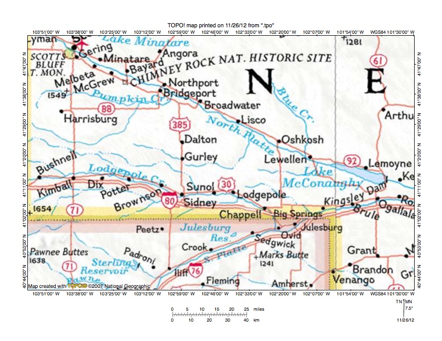
Figure 1: North Platte River-Lodgepole Creek drainage divide area location map (select and click on maps to enlarge). National Geographic Society map digitally presented using National Geographic Society TOPO software.
Figure 1 provides a location map for the North Platte River-Lodgepole Creek drainage divide area in Morrill and Cheyenne Counties, Nebraska and illustrates a region in western Nebraska and with a region in northeast Colorado south and west of Nebraska. The north to south oriented Wyoming-Nebraska border is north of Colorado along the west edge of figure 1. The North Platte River flows in a southeast direction from near the northwest corner of figure 1 to the east edge of figure 1 (south of center). The South Platte River flows in a northeast and east direction from the south edge of figure 1 (west half) to the east edge of figure 1 and east of figure 1 joins the North Platte River to form the Nebraska Platte River, which then flows to the Missouri River. Lodgepole Creek flows in an east, east-southeast, east, and southeast direction to join the northeast oriented South Platte River near Ovid, Colorado. Lodgepole Creek tributaries from the north are primarily oriented in east-southeast directions. North Platte River tributaries from the south include east oriented Pumpkin Creek. The unnamed east-southeast and northeast oriented Pumpkin Creek tributary is Rocky Hollow in the west and Lawrence Fork nearer to Pumpkin Creek. The unnamed east-southeast and north-northeast oriented North Platte River tributary flowing near Gurley, Nebraska is Rush Creek, which is an important stream in this essay. The North Platte River-Lodgepole Creek drainage divide area in Morrill and Cheyenne Counties investigated in this essay is located south of the North Platte River, north of Lodgepole Creek, east of northeast oriented Lawrence Fork, and west of the north-northeast oriented Rush Creek drainage route segment.
The North and South Platte River and tributary drainage routes in Nebraska, Wyoming, and Colorado developed during immense melt water floods from the western margin of a thick North American ice sheet. Floodwaters flowed from western Canada to and across Nebraska, Wyoming, and Colorado at a time when Wyoming and Colorado mountain ranges were beginning to emerge. Mountain ranges emerged as floodwaters flowed across them and deeply eroded surrounding regions and as ice sheet related crustal warping raised the mountain masses. Ice sheet related crustal warping also raised large regions in Wyoming and Colorado as melt water floods flowed across them and north and west of figure 1 (in Montana, Wyoming, and Colorado) played a significant role in massive flood flow reversals that affected headwaters of the South and North Platte Rivers. However, development of the North and South Platte River drainage routes and tributary drainage routes in western Nebraska was simple and was not affected by large-scale flood flow reversals. The northeast and east oriented South Platte River valley eroded headward from the Platte River valley east of figure 1 across south and southeast oriented flood flow, which had been flowing to what were at that time were the newly eroded Republican River valley and tributary valleys (south and east of figure 1-see South Platte River-Frenchman Creek drainage divide area essay). Southeast and south oriented flood flow into the newly eroded South Platte River valley eroded southeast oriented tributary valleys and the east, east-southeast, and east oriented Lodgepole Creek valley then eroded headward across the southeast oriented flood flow from one of those southeast oriented tributary valleys to capture southeast and south oriented flood flow moving to the newly eroded South Platte River valley. Floodwaters moved in anastomosing channel complexes and east-southeast oriented tributary valleys were eroded by flood flow channels captured by headward erosion of the east oriented Lodgepole Creek valley. The North Platte River valley eroded headward across south and southeast oriented flood flow, although slightly behind the South Platte River valley and Lodgepole Creek valley headward erosion and it beheaded flood flow routes to the newly eroded South Platte River and Lodgepole Creek valleys. Floodwaters on north and northwest ends of beheaded flood flow routes reversed flow direction to flow into the deep North Platte River valley and to create north oriented North Platte River tributary drainage routes. Some of these newly formed north oriented North Platte River tributary drainage captured south and southeast oriented flood flow still moving west of the actively eroding North Platte River valley head. For example, a southeast oriented valley eroded headward from the newly formed north-northeast Rush Creek drainage route segment to capture southeast oriented flood flow west of the actively eroding North Platte River valley head and as a result created the southeast and north-northeast oriented Rush Creek drainage route seen in figure 1. Headward erosion of the deep southeast oriented North Platte River valley and tributary valleys then beheaded all flood flow routes to the newly eroded Rush Creek valley.
Detailed location map for North Platte River-Lodgepole Creek drainage divide area
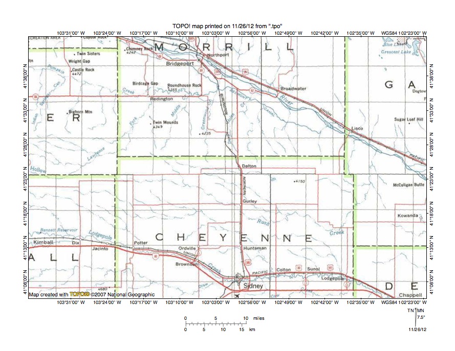
Figure 2: Detailed location map North Platte River-Lodgepole Creek drainage divide area. United States Geological Survey map digitally presented using National Geographic Society TOPO software.
Figure 2 provides a detailed location map for the North Platte River-Lodgepole Creek drainage divide area in Morrill and Cheyenne Counties, Nebraska. County boundaries are shown and Morrill and Cheyenne Counties are labeled. The North Platte River flows in a southeast direction from the north edge of figure 2 (near west edge of Morrill County) to the east edge of figure 2 (slightly south of center). Pumpkin Creek is an east-southeast and east oriented tributary flowing from the west edge of figure 2 (near northwest corner) to join the North Platte River in Morrill County. Rocky Hollow drains in an east-southeast and northeast direction from the west center edge of figure 2 to northeast oriented Lawrence Fork, which flows to Pumpkin Creek in western Morrill County. Other Pumpkin Creek tributaries include north-northeast oriented Middle Creek and north oriented Greenwood Creek. Deep Holes Creek is a north and north-northeast oriented North Platte River tributary east of Greenwood Creek. Rush Creek originates in the northwest corner region of Cheyenne County and flows in a southeast direction and near the Cheyenne County east border turns to flow in a north-northeast and north direction to join the southeast oriented North Platte River as a barbed tributary. Rush Creek tributaries are from the north and west and are primarily oriented in southeast directions. Lodgepole Creek flows in an east, east-southeast, east, and east-southeast direction from the west edge of figure 2 (south half) to the south edge of figure 2 (near southeast corner) and south of figure 2 joins the northeast oriented South Platte River. Lodgepole Creek tributaries from the north are oriented in east and southeast directions. Headward erosion of the east oriented Lodgepole Creek valley and its east oriented tributary valleys captured south and southeast oriented flood flow moving to the newly eroded South Platte River valley. Next headward erosion of the North Platte River valley beheaded flood flow routes to the newly eroded South Platte River valley. Floodwaters on north ends of beheaded flood flow routes reversed flow direction to create the north-northeast and north oriented Rush Creek drainage routes. A southeast oriented valley then eroded headward from that newly formed north-northeast and north oriented Rush Creek drainage to capture floodwaters west of the actively eroding North Platte River valley head. Headward erosion of the North Platte River valley then beheaded and reversed flood flow routes to the newly eroded southeast oriented Rush Creek valley and in sequence created the north oriented Deep Holes Creek and Greenwood Creek drainage routes. The east oriented Pumpkin Creek valley then eroded headward to capture floodwaters west of the actively eroding North Platte River valley head and the northeast oriented Lawrence Fork valley eroded headward to capture southeast oriented flood flow west of the actively eroding Pumpkin Creek valley head and beheaded flood flow routes to the newly eroded Rush Creek valley and to newly eroded east and southeast oriented Lodgepole Creek tributary valleys.
Cedar Creek-Rush Creek drainage divide area
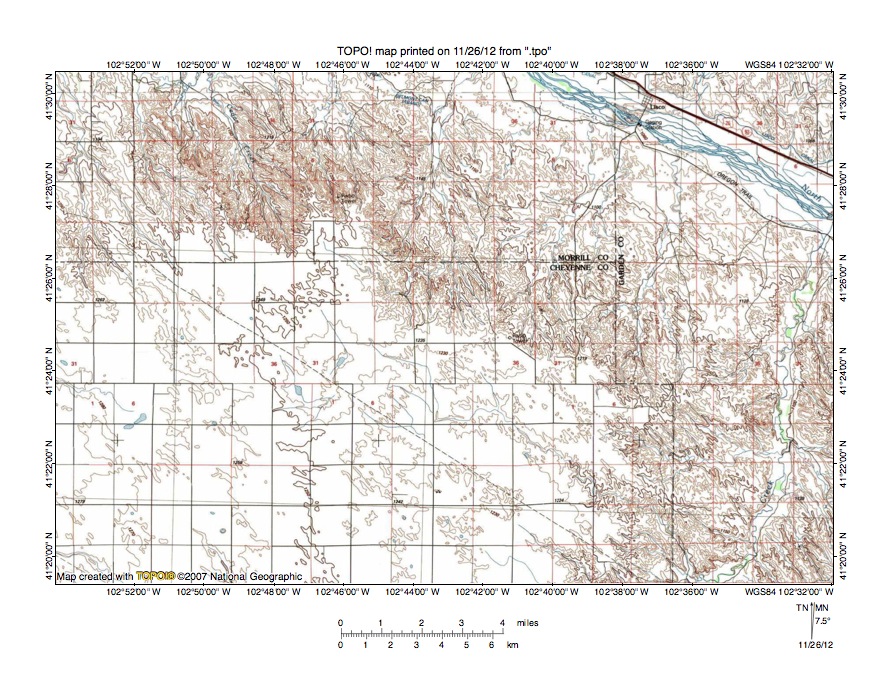
Figure 3: Cedar Creek-Rush Creek drainage divide area. United States Geological Survey map digitally presented using National Geographic Society TOPO software.
Figure 3 provides a reduced size topographic map of Cedar Creek-Rush Creek drainage divide area. The map contour interval for figure 3 is 10 meters. The North Platte River flows in a southeast direction across the northeast corner of figure 3. The North Platte River valley floor elevation is slightly higher than 1000 meters. Rush Creek flows in a northeast and north direction from the south edge of figure 3 (near southeast corner) to join the southeast oriented North Platte River as a barbed tributary near the east edge of figure 3. Rush Creek tributaries from west are oriented in southeast and south-southeast directions and join Rush Creek as barbed tributaries. Cedar Creek is a labeled north-northwest and north-northeast oriented stream flowing to the north edge of figure 3 (west half) and north of figure 3 flows in a north direction to join the southeast oriented North Platte River as a barbed tributary. Other northwest and north-northwest streams in the northwest quadrant of figure 3 flow to Cedar Creek or to an unnamed north oriented stream west of Cedar Creek. A southeast oriented Rush Creek tributary flows across the upland surface between the Cedar Creek headwaters and the north oriented Rush Creek valley. The upland surface elevation near the Cedar Creek headwaters is slightly higher than 1250 meters or almost 250 meters higher than the nearby North Platte River valley floor. The barbed tributaries and the southeast oriented Rush Creek tributary suggest the 250-meter deep North Platte River valley eroded headward along and/or across southeast oriented flood flow moving on the upland surface and that the north oriented Rush Creek valley eroded headward from the actively eroding North Platte River valley head to capture southeast oriented flood flow moving across the upland surface. Headward erosion of the North Platte River valley head then reached a point where the north oriented Cedar Creek valley could erode headward to capture southeast oriented flood flow moving to the newly eroded north oriented Rush Creek valley. Floodwaters on northwest ends of the beheaded flood flow route reversed flow direction to create the north-northwest oriented Cedar Creek headwaters valley and tributary valleys, which suggests the volumes of floodwaters involved were immense.
Rush Creek-Rush Creek drainage divide area
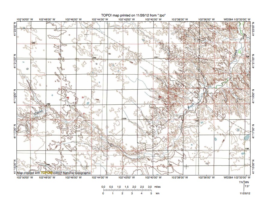
Figure 4: Rush Creek-Rush Creek drainage divide area. United States Geological Survey map digitally presented using National Geographic Society TOPO software.
Figure 4 provides a topographic map of the Rush Creek-Rush Creek drainage divide area south of figure 3 and includes an overlap area with figure 3. The map contour interval for figure 4 is 10 meters. Rush Creek flows in an east, southeast, northeast, southeast, northeast, and north direction from the west edge of figure 4 (south half) to the northeast corner of figure 4. As seen in figure 3 north of figure 4 Rush Creek flows to the southeast oriented North Platte River. Rush Creek tributaries from the west are all oriented in southeast directions and join Rush Creek as barbed tributaries suggesting headward erosion of the northeast and north oriented Rush Creek valley captured southeast oriented flood flow. Floodwaters were probably flowing across the upland surface as sheet flow, although closer to the deep Rush Creek valley the flood flow may have been concentrated into shallow flood flow channels. Prior to headward erosion of the deep north-northeast and north oriented Rush Creek valley floodwaters in the south half of figure 4 flowed in southeast directions to the newly eroded Lodgepole Creek valley (see figure 7). East and north of the northeast quadrant of figure 4 floodwaters were flowing to east and north oriented Ash Hollow, which drains to the southeast oriented North Platte River valley (see North Platte River-South Platte River drainage divide area in Deuel, Garden, and Keith Counties, Nebraska essay). Note how the Rush Creek jogs to the northeast in the southwest quadrant of figure 4 coincide with southeast oriented tributaries flowing into Rush Creek. The deep Rush Creek valley eroded headward along a southeast oriented flood flow channel and then as flood flow to that flood flow channel was beheaded by headward erosion of the North Platte River valley (or tributary valleys) Rush Creek valley headward erosion would be in a northeast direction to capture flood flow from an adjacent and yet to be beheaded southeast oriented flood flow channel (and the process was repeated at least twice).
Greenwood Creek-Rush Creek drainage divide area
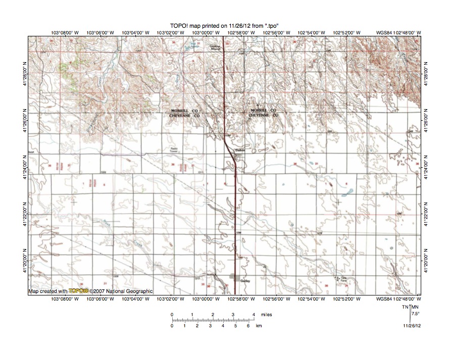
Figure 5: Greenwood Creek-Rush Creek drainage divide area. United States Geological Survey map digitally presented using National Geographic Society TOPO software.
Figure 5 illustrates a reduced size topographic map of the Greenwood Creek-Rush Creek drainage divide area west of figure 3 and there is an overlap area with figure 3. The map contour interval for figure 5 is 10 meters. The north-facing escarpment is the south wall of the east oriented Pumpkin Creek valley, which joins the southeast oriented North Platte River valley north of figure 5. Cedar Creek is the north-northwest oriented stream flowing across the northeast corner of figure 5. Cedar Creek flows in a north-northeast and north direction north of figure 5 to join the southeast oriented North Platte River. Dalton is the small town located near the center of figure 5 on the south rim of the deep Pumpkin Creek-North Platte River valley. Deep Holes Creek is the north and north-northeast oriented stream originating west of Dalton and flowing to the north center edge of figure 5. North of figure 5 Deep Holes Creek flows in a north direction to join the southeast oriented North Platte River. Greenwood Creek flows in a north-northeast and north direction west of Deep Holes Creek to the north edge of figure 5 (west half) and north of figure 5 is joins by east oriented Pumpkin Creek to flow in a north direction to the southeast oriented North Platte River. Gurley is the small town near the south center edge of figure 5. Rush Creek flows in a southeast direction across the southwest quadrant of figure 5 to the south center edge of figure 5. South and east of figure 5 Rush Creek turns to flow in a northeast and north direction to join the southeast oriented North Platte River. Other southeast oriented streams flowing to the south edge of figure 5 are Rush Creek tributaries. The east-southeast oriented stream flowing near the rim of the north-facing escarpment appears to end and not to be linked to an external drainage route. However, that east-southeast oriented drainage route probably originated as an east-southeast oriented flood flow channel to the actively eroding north-northeast and north oriented Rush Creek valley. Figure 5 illustrates how headward erosion of the deep southeast oriented North Platte River valley and its deep east oriented Pumpkin Creek valley systematically beheaded (from east to west) the southeast oriented flood flow channels that were captured by the actively eroding Rush Creek valley seen in figure 4.
Middle Creek-Greenwood Creek drainage divide area
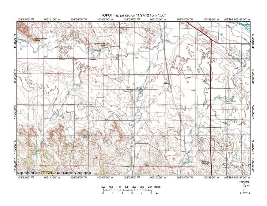
Figure 6: Middle Creek-Greenwood Creek drainage divide area. United States Geological Survey map digitally presented using National Geographic Society TOPO software.
Figure 6 provides a topographic map of the Middle Creek-Greenwood Creek drainage divide area north and west of figure 5 and includes an overlap area with figure 5. The map contour interval for figure 6 is 10 meters. The southeast oriented North Platte River is just barely seen flowing across the northeast corner of figure 6. Pumpkin Creek flows in and east and north direction from the west edge of figure 6 (near northwest corner) to the north edge of figure 6 (east of center) and joins the southeast oriented North Platte River north of figure 6. Greenwood Creek flows in a north and north-northeast direction from the south center edge of figure 6 to join Pumpkin Creek at the point where Pumpkin Creek turns to flow in a north direction. Middle Creek flows in a north-northeast direction from the south edge of figure 6 to join east oriented Pumpkin Creek south of Courthouse Rock. Deep Holes Creek flows in a north-northeast direction from the south edge of figure 6 (east half) to the east edge of figure 6 (north half) and joins the North Platte River east of figure 6. Roundhouse Rock near the northwest corner of figure 6 is located at the southeast end of the Wildcat Hills, which is a high ridge with the ridge top widening to the northwest. The Wildcat Hills are located between the southeast oriented North Platte River valley and the east oriented Pumpkin Creek valley. The east oriented Pumpkin Creek valley is linked by through valleys with the east oriented Goshen Hole escarpment-surrounded basin (see Chugwater Creek-Horse Creek drainage divide area in Goshen Hole region and Horse Creek-Pumpkin Creek drainage divide area east of Goshen Hole essays). Elevations on the upland south of the Pumpkin Creek valley are greater than 1350 meters and the high point near the northwest corner of figure 6 is 1332 meters. Elevations in the Pumpkin Creek valley south of Roundhouse Rock are between 1160 and 1170 meters suggesting the Pumpkin Creek valley is approximately 170 meters deep. Elevations in the North Platte River valley north of Roundhouse Rock are between 1120 and 1130 meters or only about 30 to 40 meters deeper than the Pumpkin Creek valley. The east oriented Pumpkin Creek valley was eroded headward by large volumes of east oriented flood flow, which eroded the deep east oriented Pumpkin Creek valley and Goshen Hole basin headward until it was beheaded by headward erosion of the north oriented Chugwater Creek valley with floodwaters then being diverted in a north and northeast direction to the southeast oriented North Platte River valley. The north oriented Deep Holes Creek, Greenwood Creek, and Middle Creek drainage routes were created as north oriented valleys eroding headward from the actively eroding east oriented Pumpkin Creek valley captured southeast oriented flood flow from west of the actively eroding Pumpkin Creek valley head. Figure 6a is a detailed topographic map of the Greenwood Creek headwaters area seen in less detail in figure 5 to illustrate southeast oriented tributaries flowing to north-oriented Greenwood Creek, which document capture of southeast oriented flood flow.
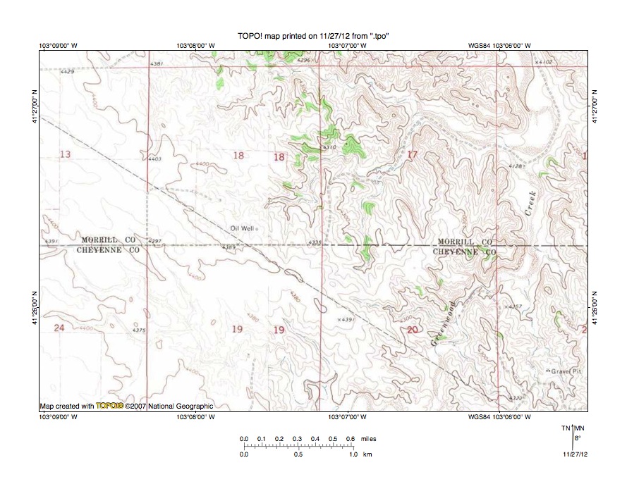
Figure 6a: Detailed map of Greenwood Creek headwaters area.
Rush Creek-Lodgepole Creek drainage divide area
Figure 7: Rush Creek-Lodgepole Creek drainage divide area. United States Geological Survey map digitally presented using National Geographic Society TOPO software.
Figure 7 illustrates the Rush Creek-Lodgepole Creek drainage divide area south of figure 4 and includes an overlap area with figure 4. The map contour interval for figure 7 is 10 meters. Lodgepole Creek flows in an east direction from the west edge of figure 7 (near southwest corner to the town of Lodgepole and then in a southeast direction to the south edge of figure 7. South of figure 7 Lodgepole Creek flows in a southeast direction to join the northeast oriented South Platte River. A southeast oriented tributary joins Lodgepole Creek near the town of Lodgepole and flows on an alignment similar to the alignment of Lodgepole Creek south and east of the town of Lodgepole. Rush Creek flows in a southeast and northeast direction from the north edge of figure 7 (west of center) to the north edge of figure 7 (east of center). North of figure 7 Rush Creek flows in a north-northeast and north direction to join the southeast oriented North Platte River. The southeast oriented Rush Creek alignment is similar to the alignments of the southeast oriented Lodgepole Creek tributary and the alignment of Lodgepole Creek south and east of the town of Lodgepole. This similarity in alignments suggests prior to headward erosion of the northeast and north oriented Rush Creek valley floodwaters flowed in a southeast direction to the southeast oriented Lodgepole Creek valley and tributary valley, which were eroding headward from the newly eroded South Platte River valley. Headward erosion of the deeper north-northeast and north oriented Rush Creek valley from the actively eroded North Platte River valley head then captured the southeast oriented flood flow and diverted floodwaters in a north direction to the newly eroded southeast oriented North Platte River valley.
Detailed map of Rush Creek-Lodgepole Creek drainage divide area
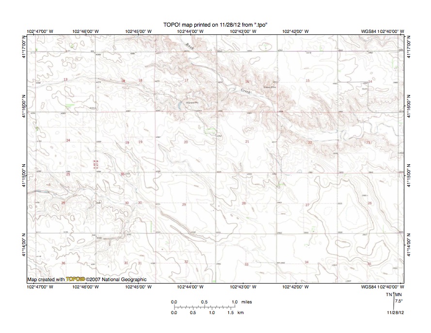
Figure 8: Detailed map of Rush Creek-Lodgepole Creek drainage divide area. United States Geological Survey map digitally presented using National Geographic Society TOPO software.
Figure 8 provides a detailed topographic map of the Rush Creek-Lodgepole Creek drainage divide seen in less detail in figure 7. The map contour interval for figure 8 is 10 feet. Rush Creek flows in a southeast and east direction from the north edge of figure 8 (west of center) to the east edge of figure 8 (north of center) and east of figure 8 turns to flow in a north-northeast and north direction to join the southeast oriented North Platte River. An east oriented tributary flows from the west edge of figure 8 (north half) across sections 13, 18, and 17 and joins Rush Creek in section 16. Southeast oriented headwaters of a southeast oriented Lodgepole Creek tributary originate in sections 24, 19, and 20 immediately south of the east oriented Rush Creek tributary and then converge to form the southeast oriented Lodgepole Creek tributary, which flows to the south edge of figure 8 (east half). South of figure 8 the tributary flows to southeast oriented Lodgepole Creek, which then flows to the northeast oriented South Platte River. Headward erosion of the east oriented Rush Creek tributary valley beheaded south oriented flood flow routes to the southeast oriented Lodgepole Creek tributary valley. A shallow northwest to southeast oriented through valley in the southwest quadrant of section 13 links the east oriented Rush Creek tributary with the westernmost of the southeast oriented Lodgepole Creek headwaters streams and is defined by two contour lines on a side. Further east in the northwest quadrant of section 21 another shallow through valley links the Rush Creek valley with the southeast oriented Lodgepole Creek tributary valley and is defined by three contour lines on a side. Continuing in an east direction a third through valley in section 22 is also defined by three contour lines on a side. Relief in the region is low and these through valleys are subtle and shallow, but do provide evidence floodwaters once crossed the present day Rush Creek-Lodgepole Creek drainage divide. Headward erosion of the 50-foot deep Rush Creek valley captured the southeast oriented flood flow and diverted floodwaters in a north direction to the North Platte River valley.
Lawrence Fork-Lodgepole Creek drainage divide area
Figure 9: Lawrence Fork-Lodgepole Creek drainage divide area. United States Geological Survey map digitally presented using National Geographic Society TOPO software.
Figure 9 illustrates a reduced size topographic map of the Lawrence Fork-Lodgepole Creek drainage divide area west and slightly south of figure 7 and there is an overlap area with figure 7. The map contour interval for figure 9 is 10 meters. The grid near the southeast corner of figure 9 is formed by roads located in a former military supply depot. Lawrence Fork flows in a northeast direction across the northwest corner of figure 9 and is located in a 100-meter deep valley. Lawrence Fork tributaries from the southeast are oriented in northwest directions. North of figure 9 Lawrence Fork flows to east and north oriented Pumpkin Creek, which then flows to the southeast oriented North Platte River. The deep north oriented valley originating just south of the county line in the northeast quadrant of figure 9 is the north oriented Greenwood Creek valley seen earlier in figure 5. Rush Creek originates in the northwest quadrant of figure 9 and flows in a southeast direction across the center of figure 9 to the east edge of figure 9 (south half). East of figure 9 Rush Creek turns to flow in a north-northeast and north direction to join the southeast oriented North Platte River. Southeast oriented streams flowing across the southwest quadrant of figure 9 are tributaries to east and southeast oriented Lodgepole Creek, which flows to the northeast oriented South Platte River. Headward erosion of the deep northeast oriented Lawrence Fork valley beheaded multiple southeast oriented flood flow routes to the newly eroded east and southeast oriented Lodgepole Creek valley and to the newly formed southeast, north-northeast, and north oriented Rush Creek valley. Floodwaters on northwest ends of beheaded flood flow routes reversed flow direction to create northwest oriented Lawrence Fork tributary drainage routes.
Detailed map of Lawrence Fork-Rush Creek drainage divide area
Figure 10: Detailed map of Lawrence Fork-Rush Creek drainage divide area. United States Geological Survey map digitally presented using National Geographic Society TOPO software.
Figure 10 provides a detailed topographic map of the Lawrence Fork-Rush Creek drainage divide area seen in less detail in figure 9. The map contour interval for figure 10 is 20 feet. Northwest and north-northwest oriented streams flowing to the north edge of figure 10 are tributaries to northeast oriented Lawrence Fork, which flows to east and north oriented Pumpkin Creek, which in turn flows to the southeast oriented North Platte River. The east-northeast and east-southeast stream flowing to the southeast corner of figure 10 flows from the southeast corner of figure 10 in a southeast direction to join southeast, north-northeast, and north oriented Rush Creek, which then flows to the southeast oriented North Platte River. Shallow through valleys link the north-northwest oriented Lawrence Fork tributary valleys with the east-southeast oriented Rush Creek tributary valley. One of the deeper through valleys is in section 33 and has a floor elevation of between 4560 and 4580 feet. Elevations east of the through valley rise to more than 4600 feet while elevations to the west of the through valley rise to more than 4660 feet (and even higher west of figure 10). These elevations suggest the section 33 through valley is at least 20 feet deep. Even shallower through valleys are seen east and west of section 33 and are defined by only a single 20-foot contour line on each side. While subtle these through valleys are evidence of southeast and south-southeast oriented flood flow channels that crossed the region prior to headward erosion of the deep northeast oriented Lawrence Fork valley. Elevations in the Lawrence Fork valley are approximately 300 feet lower than the Lawrence Fork-Lodgepole Creek drainage divide area seen in figure 10. Headward erosion of the deep northeast oriented Lawrence Fork valley from the deep east oriented Pumpkin Creek valley (which eroded headward from the southeast oriented North Platte River valley) beheaded southeast oriented flood flow to what was at that time the newly eroded east and southeast oriented Lodgepole Creek valley, which had eroded headward from the newly eroded northeast oriented South Platte River valley, and also to the newly formed southeast, north-northeast, and north oriented Rush Creek valley, which eroded headward from southeast oriented North Platte River valley.
Additional information and sources of maps studied
This essay has provided only a sample of the detailed topographic map evidence supporting the flood erosion interpretation. Many additional illustrations could be provided. Readers are encouraged to look at mosaics of detailed topographic maps to see the abundance of available data. Maps used in this study were created and published by the United States Geologic Survey and can be obtained directly from the United States Geological Survey and/or from dealers offering United States Geological Survey maps. Hard copy maps can also be observed at United States Geological Survey map depositories, which are located throughout the United States and elsewhere. Illustrations used here were created using National Geographic Society TOPO software and digital map data. TOPO software and map data can be obtained from the National Geographic Society and/or dealers offering National Geographic Society digital map data.

Leave a comment