
Abstract:
Topographic map interpretation methods are used to determine landform origins in the Smith River-Missouri River drainage divide area in Meagher and Broadwater Counties, Montana, which is also located in the Big Belt Mountains. The Missouri River flows in a north-northwest direction along the Big Belt Mountains west side and then turns to flow in a northeast direction along the Big Belt Mountains north end. The Smith River originates east of the Big Belt Mountains and flows in a north-northwest direction along the Big Belt Mountains east side to join the northeast-oriented Missouri River. East and northeast-oriented Smith River tributary valleys are linked by through valleys across present day drainage divide with southwest-oriented and barbed Missouri River tributary valleys. The through valleys are interpreted to have been eroded by diverging and converging south-oriented flood flow channels moving flood waters to what was once a major south-oriented flood flow channel on the present day north-oriented Missouri River alignment. At that time the Big Belt Mountains did not stand high as they do today and flood waters could freely flow across them. Flood waters are interpreted to have been derived from a rapidly melting thick North American ice sheet and were flowing across Montana from the ice sheet’s western margin in western Alberta. Big Belt Mountains uplift is interpreted to have occurred as flood waters flowed across them and was probably related to ice sheet caused crustal warping and possibly to crustal unloading as flood waters deeply eroded the rising mountain mass. Headward erosion of the deep Missouri River valley from space in the deep “hole” the decaying ice sheet had occupied beheaded the south-oriented flood flow channels and flood waters on north ends of the beheaded flood flow channels reversed flow direction to erode the north-northwest oriented Smith River and Missouri River valley segments.
Preface
Introduction
- The purpose of this essay is to use topographic map interpretation methods to explore the Smith River-Missouri River drainage divide area landform origins in Meagher and Broadwater Counties, Montana, USA. Map interpretation methods can be used to unravel many geomorphic events leading up to formation of present-day drainage routes and development of other landform features. While each detailed topographic map feature provides detailed evidence to be explained, the solution must be consistent with explanations for adjacent area map evidence as well as solutions to big picture map evidence puzzles. I invite readers to improve upon my solutions and/or to propose alternate solutions that better explain evidence and are also consistent with adjacent map area and big picture evidence. Readers may do so either by making comments here or by writing and publishing their own essays and to leave a comment here with a link to those essays.
- This essay is also exploring a new geomorphology paradigm in which erosional landforms are interpreted as evidence left by immense glacial melt water floods. Implied in that interpretation is the immense floods were derived from a thick North American ice sheet that created a deep “hole” in the North American continent and also melted fast. The previously unexplored paradigm being tested in this and other essays in the Missouri River drainage basin landform origins research project is a thick North American ice sheet, comparable in thickness to the Antarctic ice sheet, occupied the North American region usually recognized to have been glaciated, and through its weight and erosive actions created a deep North American “hole”. The southwestern rim of that deep “hole” is today preserved in the high Rocky Mountains. The ice sheet through its weight and deep erosion (and perhaps deposition along major south-oriented melt water flow routes) caused significant crustal warping and tectonic change, through its action of melting fast produced immense floods that flowed across the continent, and through its action of melting fast systematically opened up space in the ice sheet created “hole” so headward erosion of newly developed north-oriented drainage systems captured immense south-oriented melt water floods and diverted immense melt water floods north into space the ice sheet had once occupied.
- If this previously unexplored paradigm is correct the geographic region explored by this essay should contain evidence of immense floods that were captured by headward erosion of new valley systems so as to cause the floods to flow in a different direction. Ability of this previously unexplored paradigm to explain Smith River-Missouri River drainage divide area landform evidence in Meagher and Broadwater Counties, Montana will be regarded as evidence supporting the “thick ice sheet that melted fast” paradigm (see essay listed at header). This essay is included in the Missouri River drainage basin landform origins research project essay collection.
Smith River-Missouri River drainage divide area location map

- Figure 1 shows a large region in central Montana and provides a location map for the Smith River-Missouri River drainage divide area in Meagher and Broadwater Counties, The east-west continental divide extends in a south-southeast direction from the figure 1 north edge (near northwest corner) along and/or near the (Lewis) and Clark Range crest and then west of Helena before turning to extend in a west direction between Butte and the Big Hole River to the figure 1 west edge (south of center). Figure 1 regions east and south of the continental divide drain to the Missouri River with water eventually reaching the Gulf of Mexico. The Big Belt Mountains are a major mountain range just west of the figure 1 center. The Missouri River originates at Three Forks (south and west of the Big Belt Mountains) where the north-oriented Gallatin River, the north-oriented Madison River, and the northeast and east-oriented Jefferson River meet to form the north-oriented Missouri River. From Three Forks the Missouri River flows in a north and north-northwest direction along the Big Belt Mountains southwest margin and then at the Big Belt Mountains north end turns to flow in a northeast direction to Great Falls and the figure 1 north center edge. The north-northwest oriented Missouri River segment is flooded by reservoirs forming Canyon Ferry Lake, Hauser Lake, and Holter Lake, among others. The Smith River originates east of the Big Belt Mountains and south of White Sulphur Springs and flows in a north-northwest direction along the Big Belt Mountains east margin to join the Missouri River near the town of Ulm (near Great Falls). South of the north-northwest oriented Smith River headwaters (and south of the town of Ringling) is an unlabeled south-southeast oriented river flowing between the Big Belt Mountains and the Crazy Mountains. That unlabeled river is the Shields River and it joins the east-oriented Yellowstone River near Livingston. The Yellowstone River flows in a north-northeast direction from the figure 1 south edge (just east of center) to Livingston and then turns to flow in more of an east direction to the figure 1 east edge (south half) and east of figure 1 turns to flow in a northeast direction to eventually join the Missouri River. The Smith River has several unlabeled tributaries. The unlabeled east-oriented Smith River tributary just north of the words “Hauser Lake” is Rock Creek. The north-oriented tributary south of Rock Creek with east-oriented headwaters is Big Camas Creek. The Smith River-Missouri River drainage divide area of interest in this essay is generally located between the Rock Creek and Big Camas Creek drainage basins and the north-northwest oriented Missouri River to the west and southwest. Other essays describing Smith River drainage divide areas can be found in this Smith River drainage basin landform origins blog.
- Drainage routes in the entire figure 1 map area, and in a much larger region, evolved during immense south and southeast-oriented floods. The massive south and southeast-oriented floods were derived from a rapidly melting thick North American ice sheet located in a deep “hole.” The deep “hole’s” western rim was located in western Alberta and eastern British Columbia and immense ice-marginal melt water floods flowed in south and southeast directions from that western rim into and across Montana and then further south with significant volumes of water flowing along routes roughly corresponding with the present day east-west continental divide to eventually reach the Gulf of Mexico. At that time the Rocky Mountains did not exist and flood waters could freely flow across what are now high mountain ranges. Crustal warping, probably related to the thick ice sheet’s tremendous weight, gradually raised the Rocky Mountains (from south to north) as the immense floods flowed across them. Corresponding with the Rocky Mountain uplift deep valleys eroded headward from the Gulf of Mexico in the east and the Pacific Ocean in the west to capture the massive south and southeast-oriented melt water flood flow and to carve the present day east-west continental divide (from south to north). In time Rocky Mountain uplift combined with ice sheet melting created a situation where the south and southeast-oriented ice-marginal melt water floods were flowing on bedrock surfaces higher in elevation than the nearby ice sheet surface, especially higher in elevation than the floors of giant south-oriented ice-walled canyons being carved into the ice sheet surface by huge south-oriented supra-glacial melt water rivers. This new situation caused deep northeast and east-oriented valleys to erode headward from space being opened up in the deep “hole” the melting ice sheet had previously occupied.
- Of particular importance to this essay was a giant southeast and south oriented ice-walled canyon located in present day Saskatchewan, North Dakota, and South Dakota. In time this ice-walled canyon also become a bedrock-floored canyon and detached the ice sheet’s southwest margin. Today the northeast and east-facing Missouri Escarpment in Saskatchewan, North Dakota, and South Dakota is what remains of that giant canyon’s southwest and west wall. What makes that giant ice-walled canyon important to figure 1 is large northeast and east-oriented valleys eroded headward from it to capture the immense south and southeast-oriented flood flow in nearby Montana and northern Wyoming. First the deep northeast oriented Yellowstone River valley and its tributary valleys eroded headward from that giant ice-walled canyon to capture the immense south and southeast-oriented flood flow. The actively eroding northeast- and east-oriented Yellowstone River valley head was much deeper than the south and southeast-oriented flood flow channels it captured. Flood waters on north and northwest ends of the beheaded flood flow channels reversed flow direction to erode north and northwest-oriented tributary valleys. This process was also repeated with each Yellowstone River tributary valley, with the tributary valleys being eroded in sequence from the southeast to the northwest. Next headward erosion of the deep Missouri River valley, from the same giant ice-walled canyon, captured the south- and southeast-oriented flood flow moving to the newly eroded Yellowstone River valley. Again flood waters on north and northwest ends of beheaded flood flow channels reversed flow direction to erode north and northwest-oriented tributary valleys. And again this process was repeated for each Missouri River tributary valley with the tributary valleys being eroded in sequence.
- The north-northwest oriented Smith River valley was eroded by a reversal of flood flow on the north-northwest end of a beheaded south-southeast oriented flood flow channel. The south-southeast oriented flood water was moving to what was then the actively eroding Yellowstone River valley near present day Livingston. The flood flow reversal was probably greatly aided by uplift of the Big Belt Mountains and other regional mountain ranges which was occurring as the massive south-oriented melt water floods flowed across the region. The north-northwest oriented Missouri River valley segment west of the Big Belt Mountains was also eroded by a reversal of south-southeast oriented flood flow. That south-southeast oriented flood flow was probably flowing to diverging south-oriented flood flow channels in the Three Forks region, with the diverging flood flow channels probably moving flood waters to what was then the actively eroding Snake River valley west of Yellowstone National Park (south of the figure 1 map area). Today the Snake River eventually joins the Columbia River with water eventually reaching the Pacific Ocean. In other words prior to the reversal of flood flow in the north-northwest oriented Missouri River valley segment (west of the Big Belt Mountains) the east-west continental divide was not located where it is today. In fact the east-west continental divide was constantly changing position as headward erosion of deep valleys, combined with mountain uplift, was beheading and reversing flood flow channels and diverting the immense floods in different directions.
Detailed location map for Smith River-Missouri River drainage divide area

- Focusing now on the Smith River-Missouri River drainage divide area in Meagher and Broadwater Counties figure 2 provides a detailed location map. County boundaries are shown and Meagher and Broadwater Counties are labeled. Lewis and Clark County is the unlabeled county in the figure 2 northwest corner. Green shaded areas are National Forest lands, which are generally located in mountainous regions. The Missouri River flows in a north-northwest direction in Broadwater County and Canyon Ferry Lake is the large reservoir flooding the Missouri River valley downstream from Townsend. Note how most Missouri River tributaries from the east are oriented in southwest directions and enter the north-northwest oriented Missouri River as barbed tributaries. From the northwest to the southeast the named southwest-oriented Missouri River tributaries include Beaver Creek, Soup Creek, Trout Creek, Magpie Creek, Avalanche Creek, White Creek, and Confederate Gulch. Fewer tributaries enter the Missouri River from the west and some are oriented in northeast directions, although there are southeast-oriented tributaries as well. The south-oriented barbed tributaries are evidence the Missouri River valley was originally eroded as a south-oriented flow route. As described in the figure 1 discussion north of figure 2 the Missouri River turns to flow in a northeast direction. Headward erosion of the deep northeast-oriented Missouri River valley beheaded and reversed a major south-southeast oriented flood flow channel to erode the north-northwest oriented Missouri River valley seen in figure 2. White Sulphur Springs is a town in Meagher County near the figure 2 east center area. A short distance west of White Sulphur Springs the southwest-oriented North Fork Smith River joins the north-northwest oriented South Fork Smith River to form the north-northwest and north oriented Smith River which flows to the figure 2 north center edge. The east-oriented Smith River tributary near the figure 2 north edge and joining the Smith River just north of the figure 2 map area is Rock Creek. The labeled east-oriented Smith River tributary south of Rock Creek (and just south of the small National Forest region) is Beaver Creek. The labeled north-oriented Smith River tributary with east-oriented headwaters originating near Boulder Mountain is Big Camas Creek. Sixteenmile Creek originates near Reservation Mountain (near figure 2 southeast corner) and flows in a southwest direction through Ringling to the figure 2 south edge (east half) and joins the Missouri River south of the figure 2 map area. South of Ringling and southwest-oriented Sixteenmile Creek (and not seen in figure 2) are headwaters of a south-southeast oriented tributary (Potter Creek) flowing to the south-southeast oriented Shields River, which flows to the Yellowstone River near Livingston.
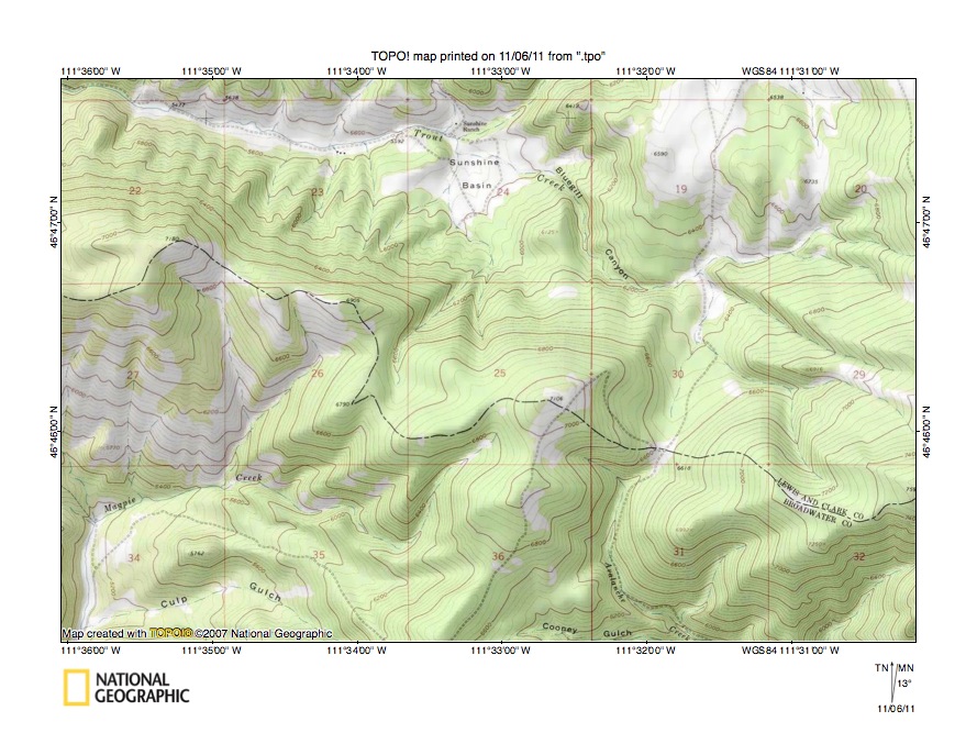
Rock Creek-Trout Creek drainage divide area

- Figure 3 illustrates the northwest end of the study region and shows the Rock Creek-Trout Creek drainage divide area. Rock Creek originates in the Jim Ball Basin and flows in a southwest direction before making a U-turn to flow in an east-northeast and east-southeast direction to the figure 3 east edge (north half) and eventually joining the north-oriented Smith River. Trout Creek originates in the Lewis and Clark County southeast “corner” in the figure 3 southeast quadrant and flows in a west-northwest direction through Bluegill Canyon and the Sunshine Basin before making an abrupt turn to flow in a south-southwest direction through Trout Creek Canyon and then in a west and southwest direction to the figure 3 southwest corner. South and west of figure 3 Trout Creek flows to the north-northwest oriented Missouri River. Note how the east-oriented Rock Creek valley and the southwest-oriented Trout Creek valley are linked by multiple through valleys crossing the present day drainage divide. Indian Flats on the northwest of Grouse Ridge would be one such through valley while another through valley can be seen along the Grouse Ridge southeast margin. Still another through valley is located just west of Snedaker Divide. The figure 3 contour interval is 50 meters and the Trout Creek valley west of the Sunshine Basin is deeper than the Rock Creek valley to the north. The drainage divide between the two valleys stands several hundred meters high, although it is crossed by several low areas or through valleys, which were eroded as south-oriented flood flow channels moving flood waters to what was then the actively eroding Trout Creek valley prior to headward erosion of the east-oriented Rock Creek valley. Flood waters came from north of the figure 3 map area and flood flow channels there are documented in the Hound Creek-Smith River drainage divide area landform origins Cascade and Meagher County, Montana essay. Headward erosion of the deep east-oriented Rock Creek valley into and across the figure 3 map area captured the south-oriented flood flow and beheaded the flood flow channels supplying flood water to the Trout Creek valley. Reversals of flood flow caused by the reversal of flood flow in what had been a south-oriented flood flow channel on the Smith River alignment next beheaded and reversed flood flow channels north of the figure 3 map area and ended flood flow to the newly eroded Rock Creek valley.
Detailed map of Rock Creek-Trout Creek drainage divide area

- Figure 4 provides a detailed topographic map of the Rock Creek-Trout Creek drainage divide area near Grouse Ridge seen in less detail in figure 3 above. Trout Creek flows in a northwest direction from the figure 4 south edge through section 16 to be joined by southeast-oriented Indian Creek and then turns abruptly to flow in a south direction (in Trout Creek Canyon) to the figure 4 south center edge. Rock Creek flows in an east-southeast direction from the figure 4 north center edge to section 34 and then turns to flow in an east-northeast direction to the figure 4 east edge (near figure 4 northeast corner). Note in the boundary area between sections 4 and 9 a through valley linking a north-oriented Rock Creek tributary valley with a south oriented Trout Creek tributary valley (draining to Trout Creek directly north of Trout Creek Canyon). The figure 4 map contour interval is 40 feet and the through valley floor elevation at the drainage divide is between 6400 and 6440 feet. Elevations on Grouse Ridge rise to more than 6960 feet while the high point in south half of section 10 to the east has an elevation of 7018 feet. In other words the through valley is at least 500 feet deep. The through valley is a water eroded valley and was eroded by south- or southwest-oriented flood flow moving to the actively eroding south-oriented Trout Creek valley. At that time the south-oriented Trout Creek valley was probably eroding headward from a south-oriented flood flow channel on the alignment of the present day north-oriented Missouri River. The northwest-oriented Trout Creek valley segment was eroded by a reversal of southeast-oriented flood flow moving to the Sunshine Basin and Bluegill Canyon and then to the south-oriented Avalanche Creek valley (seen in figure 6 below). Headward erosion of the deep south-oriented Trout Creek Canyon beheaded the southeast-oriented flood flow channel to the actively eroding Avalanche Creek valley and flood waters on the northwest end of the beheaded flood flow channel reversed flow direction to erode the northwest-oriented Trout Creek valley segment. The southeast-oriented Indian Creek valley is linked west of Grouse Ridge (and the figure 4 map area) with a northwest-oriented Cottontail Gulch valley which drains to southwest-oriented Boulder Creek with Boulder Creek being another barbed Missouri River tributary. Headward erosion of the deep southwest-oriented Boulder Creek valley beheaded the southeast-oriented flood flow channel to the actively eroding southeast-oriented Indian Creek valley and flood waters on the northwest end of the beheaded flood flow channel reversed flow direction to erode the northwest-oriented Cottontail Gulch valley. At the time these deep valleys were eroding headward across diverging and converging south-oriented flood flow channels the Big Belt Mountains were probably rising, which aided in the erosion of deep valleys and in the flood flow reversals that took place. Volumes of flood water flowing across the figure 4 map at that time were immense and only ended after flood flow reversals north of figure 4.
Rock Creek-Beaver Creek drainage divide area

- Figure 5 illustrates the Rock Creek-Beaver Creek drainage divide area east of the figure 3 map area and includes overlap areas with figure 3. Rock Creek originates in the Jim Ball Basin (near figure 5 northwest corner) and flows in a southwest, east-northeast, east-southeast, and east-northeast direction to the figure 5 north edge (near the figure 5 northeast corner). East of figure 5 Rock Creek joins the north oriented Smith River. Buffalo Creek is a north-oriented tributary joining Rock Creek at the small town on Lingshire (in figure 5 northeast quadrant). The mountains east of Buffalo Creek are known as the Dry Range. The north- and east-oriented stream flowing from the figure 5 south edge (east half) to the figure 5 east edge (near southeast corner) is Beaver Creek and the east-southeast oriented stream just north of Beaver Creek is Dry Beaver Creek and joins Beaver Creek near the figure 5 east edge. East of the figure 5 map area Beaver Creek joins the north-oriented Smith River. Note a well-defined northwest-southeast oriented through valley between the Dry Range and the Big Belt Mountains (the mountain area in the figure 5 west half) linking the north-oriented Buffalo Creek valley with the east-southeast oriented Beaver Creek valley. The figure 5 map contour interval is 50 meters and the through valley floor elevation is between 1650 and 1700 meters. The high point seen in the Dry Range has an elevation of 1995 meters and Avalanche Butte to west (where the three counties meet) exceeds 2250 meters in elevation. The through valley may be a structural feature, but it is also a water eroded feature and was eroded by southeast-oriented flood flow moving probably to a south-oriented flood flow channel on the present day north-oriented Smith River alignment. Trout Creek originates near where the three counties meet and flows in a northwest direction through Bluegill Canyon to the Sunshine Basin and then to the figure 5 west edge (north of center). South of Bluegill Canyon are south-oriented headwaters of Avalanche Creek which flows in a south and southeast direction to the figure 5 south center edge and then south of the figure 5 map area flows in a south-southwest direction to join the north-northwest oriented Missouri River as a barbed tributary. Note the north-south oriented through valley linking the Trout Creek valley in Bluegill Canyon with the south-oriented Avalanche Creek headwaters valley. The through valley floor elevation at the drainage divide is between 2000 and 2050 meters. Elevations on Avalanche Butte to the east rise to more than 2250 meters and elevations on the ridge immediately to the west rise to more than 2150 meters while elevations greater than 2250 meters can be found west of south-southwest oriented Trout Creek Canyon seen in figure 3. This through valley was also eroded as a south-oriented flood flow channel and was beheaded when headward erosion of the deep south-southwest oriented Trout Creek Canyon (in figure 3) beheaded and reversed the southeast-oriented flood flow channel supplying flood water to it. Figure 6 below provides a detailed topographic map to better illustrate the Trout Creek-Avalanche Creek drainage divide area.
Detailed map of Trout Creek-Avalanche Creek drainage divide area
- Figure 6 provides a detailed topographic map of the Trout Creek-Avalanche Creek drainage divide area seen in less detail in figure 5 above. The Sunshine Basin is located in section 24 just south of the figure 6 north center edge. Trout Creek flows in a northwest direction through Bluegill Canyon to the Sunshine Basin and then in a west-northwest direction to the figure 6 northwest corner. Note the north-oriented Trout Creek tributary in section 30 (south of the Bluegill Canyon east end) which is linked by a well-defined north-south oriented through valley with Avalanche Creek which flows in a south and southeast direction in section 31 to the figure 6 south edge. The figure 6 map contour interval is 40 feet and the through valley floor elevation at the drainage divide is between 6600 and 6640 feet. The elevation on the ridge to the east at the figure 6 east edge is 7597 feet while the high point in the section 25 southeast corner is 7106 (west of figure 6 and west of south-southwest oriented Trout Creek Canyon elevations greater than 7700 feet can be found. Using the section 25 high point as defining elevation the through valley is approximately 500 feet deep and using the high points west of figure 6 as defining elevations the through valley may be just a channel eroded into the floor of a much broader south-oriented flood flow channel and may record as much as 1000 feet of flood erosion in the region. The through valley was eroded at a time when southeast-oriented flood flow moving on the present day northwest-oriented Trout Creek valley alignment probably converged with south- and south-southwest oriented flood flow from north of figure 6 to form a south-oriented flood flow channel to what was then the actively eroding Avalanche Creek valley. The deep Avalanche Creek valley had eroded headward from what was then a south-oriented flood flow channel on the present day north-oriented Missouri River alignment. Headward erosion of the deeper south-southwest oriented Trout Creek Canyon valley west of the figure 6 map beheaded and reversed the southeast-oriented flood flow so as to erode the northwest-oriented Trout Creek valley which then captured the southwest and south-oriented flood flow from the north. Soon thereafter headward erosion of the east-oriented Rock Creek valley north of the figure 6 map area captured the southwest and south-oriented flood flow and ended flood flow to the figure 6 map area.
Benton Gulch-Confederate Gulch drainage divide area
- Figure 7 illustrates the Benton Gulch-Confederate Gulch drainage divide area south and east of the figure 5 map area (there is no overlap). The Meagher County-Broadwater County boundary is shown and labeled and is defined by the Smith River-Missouri River drainage divide (with the Smith River drainage basin being in Meagher County). The edge of the north-northwest oriented Missouri River valley can be seen in the figure 7 southwest corner. Avalanche Creek flows in a south-southwest direction across the figure 7 northwest corner. Whites City is a small town located west of the figure 7 center. The south-southwest and southwest oriented stream flowing to the figure 7 west edge (south half) is White Gulch. Diamond City is another small town located in the east half of the figure 7 southwest quadrant. The southwest-oriented stream flowing through Diamond City is Confederate Gulch. South-oriented Greenhorn Gulch and Montana Gulch join Confederate Gulch near Diamond City. Boulder Creek is a northwest and west-oriented tributary flowing from the figure 7 south edge (east of center) to join Confederate Gulch a short distance downstream from Diamond City. Cement Gulch is a south-southeast oriented tributary in the figure 7 center region and joins Confederate Gulch upstream from Diamond City. North-oriented Benton Gulch headwaters are directly north of the south-oriented Cement Gulch headwaters and Benton Gulch drains in a north, northeast, and east-northeast direction to the figure 7 northeast corner and east and north of the figure 7 map area joins the north-oriented Smith River. Horse Gulch is a south-southeast oriented tributary just east of the figure 7 north center edge area and is linked by a north-south oriented through valley (north of the figure 7 map area) with the large northwest-southeast oriented through valley located between the Dry Range and the Big Belt Mountains and which was seen in figure 5. Note how today the north-oriented Benton Gulch headwaters valley is linked by a through valley with the south-oriented Cement Gulch valley. The figure 7 map contour interval is 50 meters and the through valley floor elevation at the drainage divide is between 1850 and 1900 meters. Elevations greater than 2050 meters can be found on ridges on either side of the through valley meaning the through valley is at least 150 meters deep. The through valley was eroded by south-oriented flood water which was moving on a flood flow channel between the Dry Range and the Big Belt Mountains and which was eroding the southwest-oriented Confederate Gulch and south-oriented Cement Gulch valleys headward from a south-oriented flood flow channel on the present day north-oriented Missouri River alignment. Headward erosion of the deep east-northeast oriented Benton Gulch valley from what may have been a south-oriented flood flow channel on the Smith River alignment captured the south-oriented flood flow channel and beheaded the south-oriented flood flow channel to the Cement Gulch valley. Flood waters on the north end of the beheaded flood flow reversed flow direction to erode the north-northeast oriented Benton Gulch valley segment while the south-southeast oriented Horse Gulch valley eroded headward from the east-northeast oriented Benton Gulch valley.
Detailed map of Benton Gulch-Cement Gulch drainage divide area

- Figure 8 provides a detailed map of the Benton Gulch-Cement Gulch drainage divide area seen in less detail in figure 7 above. White Gulch is the south-southwest oriented valley draining across the figure 8 northwest corner. Benton Gulch originates in section 8 northwest corner (near figure 8 center) and drains in a north and north-northeast direction to the figure 8 north center edge. Cement Gulch originates in the east half of section 8 and drains in a northwest direction almost to the Benton Gulch headwaters in the section 8 northwest corner before turning to drain in a south direction to the figure 8 south center edge. Note how both Benton Gulch and Cement Gulch have west-oriented headwaters in the section 8 northwest corner. Also note how the two opposing streams are linked by a well-defined and deep through valley in the section 8 northwest corner. The figure 8 map contour interval is 40 feet and the through valley floor elevation at the drainage divide is shown as a spot elevation as 6134 feet. The ridge to the east rises to 6835 feet in the section 9 southwest corner and the ridge to the west rises to 6842 near the east center edge of section 12. In other words the through valley is 700 feet deep. The through valley was eroded by south-oriented flood flow moving from between the Dry Range and Big Belt Mountains in the through valley seen in figure 5 to a south-oriented flood flow channel on the present day north-oriented Missouri River alignment. The northwest-oriented Cement Gulch headwaters valley was eroded by a reversal of southeast-oriented flood flow, which was flowing across the region prior to headward erosion of the deep south-oriented Cement Gulch valley. Headward erosion of the deep east-northeast oriented Benton Gulch valley seen in figure 7 beheaded the south-oriented flood flow to the actively eroding Cement Gulch valley. Flood waters on the north end of the beheaded flood flow channel reversed flow direction to erode the north-oriented Benton Gulch headwaters valley and to create the Benton Gulch-Cement Gulch drainage divide (and also the Smith River-Missouri River drainage divide). Note in the figure 8 northwest quadrant near the boundary between sections 1 and 6 a west to east oriented through valley linking south-southwest oriented White Gulch with the north-northeast oriented Benton Gulch valley. The through valley was probably eroded by south-oriented flood flow still flowing in the White Gulch drainage basin which was to the newly beheaded and reversed Benton Gulch valley and represents one of several flood flow channels that supplied the volumes of water required to erode the deep north-northeast oriented Benton Gulch valley.
Boulder Creek-Camas Creek drainage divide area

- Figure 9 illustrates the Boulder Creek-Big Camas Creek drainage divide area south and east of figure 7 and includes overlap areas with figure 7. Diamond City is the small town near the figure 9 northwest corner and Confederate Gulch drains in a southwest and south-southwest direction across the figure 9 northwest corner. Boulder Creek originates at Boulder Lake just north of Boulder Mountain (west of figure 9 center) and flows in a northwest and west direction to join south-southwest oriented Confederate Gulch near the figure 9 northwest corner. Big Camas Creek originates on the east side of Boulder Baldy and flows in an east direction to east of the forested region (or mountain front) and then turns to flow in a north direction as Camas Creek to the figure 9 north edge (east half). North of figure 9 Camas Creek flows in a north direction to join the north-northwest oriented Smith River. Middle Fork Big Camas Creek originates south of Boulder Baldy and east of Boulder Mountain and flows in a southeast, east, and northeast direction to join east-oriented Big Camas Creek. Note how the northwest-oriented Boulder Creek headwaters valley and the southeast-oriented Middle Fork headwaters valley are linked by a northwest-southeast oriented through valley between Boulder Mountain and Boulder Baldy. Boulder Mountain and Boulder Baldy are the highest points in figure 9 and the through valley is evidence of a southeast-oriented flood flow channel that was eroded into an erosion surface equivalent in elevation, if not higher, to the top of Boulder Mountain (and/or Boulder Baldy). The figure 9 map contour interval is 50 meters and the Boulder Baldy elevation is 2726 meters while Boulder Mountain rises to more than 2650 meters. The through valley floor elevation at the drainage divide is between 2500 and 2550 meters meaning the through valley is at least 100 meters deep. The southeast-oriented flood flow was probably moving to a deep south-southeast oriented flood flow channel on the present day Smith River-Shields River alignment. That deep south-southeast oriented flood flow channel probably eroded headward from what was then the newly eroded Yellowstone River valley. At that time the deep Missouri River valley seen along the west edge of the figure 9 map area (especially near the southwest corner) did not exist and the region to the west was as high or higher than the erosion surface defined by the top of Boulder Mountain (and/or Boulder Baldy). As previously mentioned the Missouri River valley was probably initiated as a south-oriented flood flow channel and headward erosion of deep south-southwest oriented tributary valleys (such as the Confederate Gulch valley) beheaded and reversed the southeast-oriented flood flow to the Middle Fork valley so as to erode the northwest-oriented Boulder Creek valley segment. Subsequently, when Missouri River valley headward erosion (north of study region) beheaded and reversed flood flow on the Smith River alignment, a south-oriented flood flow channel on the present day north-oriented Camas Creek alignment was also reversed to erode the north-oriented Camas Creek valley and to capture east-oriented Big Camas Creek. The erosion of regions surrounding Boulder Baldy and Boulder Mountain, the Missouri River valley, and the Smith River valley involved multiple steps including probably uplift of mountains and what was in fact a multi-step process has been greatly simplified in this discussion.
Detailed map of Boulder Creek-Middle Fork Big Camas Creek drainage divide area

- Figure 10 provides a detailed topographic map of the Boulder Creek-Middle Fork Big Camas Creek drainage divide area seen in less detail in figure 9 above. The figure 10 map contour interval is 40 feet. Boulder Mountain is located in the section 16 northeast corner and reaches an elevation of 8810 feet. Boulder Baldy is located in the section 10 northeast quadrant and has an elevation of 8942 feet. Boulder Creek originates in what might be a north-facing cirque just north of Boulder Mountain and flows in a north and north-northwest direction to the figure 10 northwest corner. Big Camas Creek originates in section 11 and flows in a southeast and east-southeast direction to the figure 10 east edge (south half). The Middle Fork Big Camas Creek originates in the section 14 northwest corner and flows in a southeast and east-northeast direction to join Big Camas Creek. A northwest-southeast oriented through valley or mountain pass in section 10 links the north-northwest oriented Boulder Creek valley with the southeast oriented Middle Fork Big Camas Creek headwaters valley. The through valley floor elevation at the drainage divide is between 8320 and 8360 feet. Using the Boulder Mountain elevation the through valley is almost 500 feet deep. While today the through valley appears as a pass between two high mountain peaks the through valley is in fact a water eroded feature and provides evidence of a former flood flow channel route. At the time the through valley was eroded Boulder Mountain and Boulder Baldy were not high isolated mountain peaks as they are today. Instead the entire figure 10 map area and all regions to the north and west were at an elevation equivalent to the present day Boulder Mountain (and possibly the Boulder Baldy) elevation. Flood waters could freely flow from the northwest to the figure 10 map area and erode the deep southeast- and east-oriented Big Camas Creek headwaters and tributary valleys into the figure 10 map area. Headward erosion of deep south-oriented flood flow channels then began to erode regions west of the figure 10 and beheaded and reversed flood flow on the Boulder Creek alignment to erode the north-northwest oriented Boulder Creek valley. Subsequently the south-oriented flood flow channels both east and west of the figure 10 map area were beheaded and reversed by headward erosion of the much deeper northeast-oriented Missouri River valley north of figure 10.
- If Boulder Creek originates in a north-facing cirques the question might be asked when and how did the alpine glacier form? The immense southeast-oriented melt water floods from the rapidly melting thick North American ice sheet were responsible for eroding the present day deep valleys while delayed crustal warping caused by the thick ice sheet’s tremendous weight was responsible for uplifting present day mountain ranges and downwarping present day basins there were no alpine glaciers at the time the massive south and southeast-oriented floods flowed across the figure 10 map area. In fact, at that time regional climates were such the thick ice sheet to the north and east was melting rapidly and the climate was not conducive to the formation of alpine glaciers (and at that time there probably were no high mountains in the region). Further, probably at that time flood waters were still flowing freely across the high mountains seen today, which means the mountain ranges were just beginning to be uplifted and had not yet reached their present day elevations. So what happened to change the situation and to create alpine glaciers in the figure 10 map area? Remember the giant south-oriented ice-walled canyons being carved into the decaying thick ice sheet surface. For most of the ice sheet’s melt down history huge south-oriented melt water rivers flowed in these giant south-oriented ice-walled canyons and supplied massive floods that eroded the Mississippi and Missouri River (and probably Ohio River) valley systems headward in the region east of Montana with the immense water volumes flowing to the Gulf of Mexico. Once in the Gulf of Mexico the huge melt water floods pushed warm Gulf of Mexico water into the Atlantic Ocean where ocean currents carried the warm water into the North Atlantic to warm the Northern Hemisphere and to accelerate the ice sheet melting.
- However, very late in the ice sheet’s melt down history deep north-oriented ice-walled canyons captured the south-oriented meltwater rivers which had been flowing in the south-oriented ice-walled canyons. These deep north-oriented ice-walled canyons provided much shorter routes to sea level (which was lower at that time) and in time captured almost all of the decaying ice sheet’s melt water flood flow. This diversion of the decaying ice sheet’s melt water flood flow from the Gulf of Mexico to the North Atlantic and even to the Arctic Ocean completely changed Atlantic Ocean ocean currents so cold water was moving south and cooling the Northern Hemisphere. The result was a significant cooling of the North American climate and the north-oriented melt water floods began to freeze in what were then north-oriented ice-walled canyons. The frozen flood waters were located between thick ice sheet remnants and the combination of the frozen melt water and thick ice sheet remnants created a thin ice sheet located on the former thick ice sheet floor. At the same time the colder North American climate created conditions ideal for alpine glacier formation on what were then newly uplifted and deeply eroded mountain ranges formed during the thick ice sheet’s rapid melt down. In time the thin ice sheet gradually melted, although without the immense melt water floods that occurred during the thick ice sheet’s rapid melt down. Also, the North American climate stabilized to conditions probably similar to those that exist today, which resulted in the melting of at least some of the alpine glaciers.

Leave a comment