A5Gwynedd Valley Water Gap
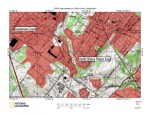
Figure 7: Wissahickon Creek valley showing the North Wales and Gwynedd Valley water gaps. Downstream from the North Wales water gap Wissahickon Creek flows in an east direction before turning in a south direction to flow through the Gwynedd Valley water gap. Southwest oriented Trewellyn Creek and Willow Run flow on either side of the eroded ridge, which is approximately 350 feet high or about 100 feet higher than the Wissahickon Creek valley floor. Headwaters of southwest oriented Stony Creek can be seen on the northwest side of the ridge west of the Wissahickon Creek valley. Stony Creek flows to Skippack Creek, which then flows to Perkiomen Creek, which flows to the Schuylkill River. The gap linking the Stony Creek headwaters with the Wissahickon Creek valley has an elevation of approximately 300 feet and is about 50 feet lower in elevation than the ridge crest. United States Geological Survey map presented using National Geographic TOPO software.