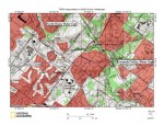
A4NorthWalesWaterGap
Figure 6: Wissahickon Creek water gap near North Wales is located near center of map. Wissahickon Creek flows in a south-southwest and south-southeast direction from the map north center edge to the water gap and south of the water gap turns to flow in an east direction to near the map southeast corner. Southwest oriented Zacharias Creek headwaters are located in the map northwest corner, with Zacharis Creek flowing to south and southwest oriented Skippack Creek, which flows to Perkiomen Creek, which in turn flows to the Schuylkill River. Note ridge extending from the map southwest corner to the map northeast corner through which Wissahickon Creek has eroded its North Wales water gap. Unnamed southwest oriented tributaries join Wissahickon Creek south of the water gap. United States Geological Survey map presented using National Geographic TOPO software.